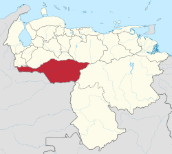
Apure
{{{official_name}}} {{{native_name}}} | |
|---|---|
| Motto(s): none | |
 Location athin Venezuela | |
| Kintra | Venezuela |
| Created | 1901 |
| Caipital | San Fernando de Apure |
| Govrenment | |
| • Govrenor | Ranón Carrizales (2011–2012) |
| Area | |
| • Total | 76500 km2 (29,500 sq mi) |
| Area rank | 3rd |
| 8.35% of Venezuela | |
| Population (2007 est.) | |
| • Total | 473,900 |
| • Rank | 19th |
| 1.63% o Venezuela | |
| Time zone | UTC-04:00 |
| ISO 3166 code | VE-C |
| Emblematic tree | Merecure licania (Licania pyrifolia) |
| Website | www |
Apure State (Spaingie: Estado Apure, IPA: [esˈtaðo aˈpuɾe]) is ane o the 23 states (estados) intae which Venezuela is dividit. Its territory formit pairt o the provinces o Mérida, Maracaibo, an Barinas, in accordance wi successive territorial ordinations pronooncit bi the colonial authorities. In 1824 the Depairtment o Apure wis creatit, unner jurisdiction o Barinas, which laid the foondations for the current entity. In 1856 it separatit frae Barinas an for the first time Apure appeared as an independent province, which in 1864 acquired the status o state. In 1881, housomeivver, a new territorial diveesion combined Apure an Guayana tae form a single state namit Bolívar. In 1899 it reestablished its autonomy an feenally, bi means o the Constitution o 1909, gained its current borders.
Municipalities an municipal seats
[eedit | eedit soorce]- Achaguas (Achaguas)
- Biruaca (Biruaca)
- Muñoz (Bruzual)
- Páez (Guasdualito)
- Pedro Camejo (San Juan de Payara)
- Rómulo Gallegos (Elorza)
- San Fernando (San Fernando de Apure)
See an aw
[eedit | eedit soorce]| Wikimedia Commons haes media relatit tae Apure. |

