Gibara
Gibara | |
|---|---|
 The toun o Gibara | |
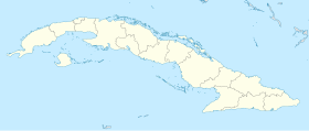
Location o Gibara in Cuba | |
| Coordinates: 21°06′26″N 76°08′12″W / 21.10722°N 76.13667°W | |
| Kintra | |
| Province | Holguín |
| Established | 1817[1] |
| Area | |
| • Total | 630 km2 (240 sq mi) |
| Elevation | 45 m (148 ft) |
| Population (2004)[3] | |
| • Total | 72,810 |
| • Density | 115.6/km2 (299/sq mi) |
| Time zone | UTC-5 (EST) |
| Area code(s) | +53-24 |
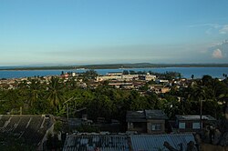
Gibara is a municipality o the Province o Holguín in the Republic o Cuba. The main ceety wis foondit on January 16, 1817. It is kent as "The White Toun" an aw, Spaingie: La Villa Blanca. Gibara haes a bonnie an breezy landscape, an possesses excellent airchitectural designs an a well-plannit layoot o its streets, hooses an pairks. Even so, Gibara's biggest asset, accordin tae visitors, are its fowk, which are describit as cooperative, friendly, affectionate, an proud o their veelage an o its history. It is said Admiral Christopher Columbus haed remarkit o Gibara's environs that “it is the maist bonnie laund that human eyes saw.”
"The White Villa" in Gibara, although sma, is said tae possess a peculiar chairm, exhibitin an airchitectural patrimony reflectin amaist twa centuries o history, as well as its fowk's cultural ruits.
Currently, some controversy exists aboot whether it wis the Bay o Gibara or the Bay of Bariay that Admiral Christopher Columbus' ships reached durin his first voyage tae Cuba.
Gibara wis declared a Naitional Monument in 2002; additionally, syne 2003, the Internaitional Festival o Poor Cinema, whaur films are presentit in a nummer different categories, haes been held in this sma coastal ceety.

Demografics
[eedit | eedit soorce]In 2004, the municipality o Gibara haed a population o 72,810.[3] Wi a total aurie o 630 km2 (240 sq mi),[2] it haes a population densitie o 115.6/km2 (299/sq mi).
The municipality is dividit intae the barrios o Arroyo Blanco, Blanquizal, Bocas, Candelaria, Cantimplora, Cupeycillos, Palmita, Rabón.[1]
See an aw
[eedit | eedit soorce]References
[eedit | eedit soorce]- ↑ a b Guije.com. "Gibara". Retrieved 5 October 2007. (in Spaingie)
- ↑ a b Statoids. "Municipios of Cuba". Retrieved 5 October 2007.
- ↑ a b Atenas.cu (2004). "2004 Population trends, by Province and Municipality" (in Spanish). Archived frae the original on 27 September 2007. Retrieved 5 October 2007.CS1 maint: unrecognised leid (link)

