Lichfield
Appearance
Lichfield
| |
|---|---|
 Frae tap left: Lichfield Cathedral; Samuel Johnson Birthplace Museum; Quonians Lane; Garrick Theatre; Cityscape. | |
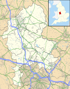
Location within Staffordshire | |
| Area | 14.02 km2 (5.41 sq mi) [1] |
| Population | 32,219 [2] |
| • Density | 2,298/km2 (5,950/sq mi) |
| OS grid reference | SK115097 |
| • Lunnon | 110 mile (180 km) NNW |
| Ceevil pairish |
|
| Destrict | |
| Shire coonty | |
| Region | |
| Kintra | Ingland |
| Sovereign state | Unitit Kinrick |
| Post toun | LICHFIELD |
| Postcode destrict | WS13, WS14 |
| Diallin code | 01543 |
| Police | Staffordshire |
| Fire | Staffordshire |
| Ambulance | Wast Midlands |
| EU Pairlament | Wast Midlands |
| UK Pairlament | |
| Wabsteid | www.lichfield.gov.uk |
Lichfield /ˈlɪtʃfiːld/ is a cathedral ceety an ceevil pairish[3] in Staffordshire, Ingland. ane o aicht ceevil pairishes wi ceety status in Ingland, Lichfield is situatit roughly 16 mi (26 km) north o Birmingham. At the time o the 2011 Census the population wis estimatit at 32,219 an the wider Lichfield District at 100,700.[4]
References
[eedit | eedit soorce]- ↑ "Lichfield City Council - Statistics". Archived frae the original on 24 Julie 2011.
- ↑ "Lichfield Parish Population Density, 2011". Neighbourhood Statistics. Office for National Statistics. 30 Januar 2013. Archived frae the original on 22 Apryle 2017. Retrieved 30 Januar 2013.
- ↑ "Names and codes for Administrative Geography". Office for National Statistics. 31 December 2008. Archived frae the original on 3 Apryle 2010. Retrieved 15 September 2009. Unknown parameter
|deadurl=ignored (help) - ↑ "Office for National Statistics - Census 2011". 20 Julie 2012.
Freemit airtins
[eedit | eedit soorce]| Wikimedia Commons haes media relatit tae Lichfield. |

