Sinaloa
Sinaloa Estado Libre y Soberano de Sinaloa | |
|---|---|
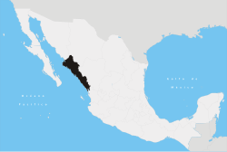
 State of Sinaloa within Mexico | |
| Coordinates: 25°0′10″N 107°30′10″W / 25.00278°N 107.50278°W | |
| Kintra | Mexico |
| Caipital | Culiacán Rosales |
| Lairgest Ceety | Culiacán Rosales |
| Municipalities | 18 |
| Admission | October 14, 1830[1] |
| Order | 20t |
| Govrenment | |
| • Govrenor | Mario López Valdez |
| • Senators[2] | Francisco Labastida Margarita Villaescusa (I) María Serrano |
| • Deputies[3] | |
| Area | |
| • Total | 57377 km2 (22,153 sq mi) |
| Ranked 18t | |
| Highest elevation | 2520 m (8,270 ft) |
| Population (2010)[6] | |
| • Total | 2,767,761 |
| • Rank | 15t |
| • Density | 48/km2 (120/sq mi) |
| • Density rank | 18t |
| Demonym(s) | Sinaloense |
| Time zone | UTC−7 (MST) |
| • Summer (DST) | UTC−6 (MDT) |
| Postal code | 80-82 |
| Aurie code | |
| ISO 3166 code | MX-SIN |
| HDI | |
| GDP | US$ 13,749,376.25 th[a] |
| Website | Official Website |
| ^ a. The state's GDP wis $175,992,016 thoosan o pesos in 2008,[6] amount correspondin tae $13,749,376.25 thoosan o dollars, being a dollar worth 12.80 pesos (value o 3 Juin 2010).[7] | |
Sinaloa (Spaingie pronunciation: [sinaˈloa]) offeecially Estado Libre y Soberano de Sinaloa (Scots: Free an Sovereign State o Sinaloa) is ane o the 31 states which, wi the Federal Destrict, comprise the 32 Federal Entities o Mexico. It is dividit in 18 municipalities an its caipital ceety is Culiacán Rosales.
It is locatit in Northwastren Mexico. It is bordered bi the states o Sonora tae the north, Chihuahua an Durango tae the east (separatit frae them bi the Sierra Madre Occidental) an Nayarit tae the sooth. Tae the wast, Sinaloa haes a significant share o coastline on the Gulf o Californie.
The state covers an aurie o 57,377 square kilometer (22,153 sq mi), an includes the Islands o Palmito Verde, Palmito de la Virgen, Altamura, Santa María, Saliaca, Macapule an San Ignacio.
In addition tae the caipital ceety, the state's important ceeties include Mazatlán an Los Mochis.
See an aw
[eedit | eedit soorce]Notes
[eedit | eedit soorce]- ↑ "Ley. Reglas para la división del Estado de Sonora y Sinaloa" (in Spanish). Archived frae the original on 17 October 2019. Retrieved 25 Januar 2012.CS1 maint: unrecognised leid (link)
- ↑ "Senadores por Sinaloa LXI Legislatura". Senado de la Republica. Retrieved 6 Apryle 2011.
- ↑ "Listado de Diputados por Grupo Parlamentario del Estado de Sinaloa". Camara de Diputados. Archived frae the original on 16 Mairch 2012. Retrieved 6 Apryle 2011.
- ↑ "Resumen". Cuentame INEGI. Archived frae the original on 14 Mey 2013. Retrieved 6 Apryle 2011.
- ↑ "Relieve". Cuentame INEGI. Archived frae the original on 14 October 2010. Retrieved 6 Apryle 2011.
- ↑ a b "Mexico en Cifras". INEGI. Retrieved 6 Apryle 2011.
- ↑ "Reporte: Jueves 3 de Junio del 2010. Cierre del peso mexicano". www.pesomexicano.com.mx. Archived frae the original on 8 Juin 2010. Retrieved 10 August 2010.
References
[eedit | eedit soorce]- C. Michael Hogan. 2009. Elephant Tree: Bursera microphylla, GlobalTwitcher.com, ed. N. Stromberg
- Asociacion de Gestores del Patrimonio Historico y Cultural de Mazatlán. 2009. The Mesoamerican Ballgame-Ulama
Freemit airtins
[eedit | eedit soorce]- (in Spaingie) Sinaloa state govrenment Archived 2011-02-28 at the Wayback Machine
- The History of Indigenous Sinaloa Archived 2012-02-10 at the Wayback Machine
- PBS Frontline: The place Mexico's drug kingpins call home


