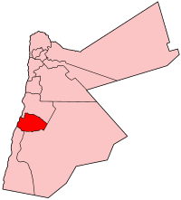
Tafilah Govrenorate
The "Scots" that wis uised in this airticle wis written bi a body that haesna a guid grip on the leid. Please mak this airticle mair better gin ye can. (Dizember 2020) |


Tafilah (Arabic: الطفيلة) is ane o the govrenorates o Jordan, locatit aboot 180 km sooth-wast o Amman, Jordan's caipital.
Tafilah Govrenorate is bordered bi Karak Govrenorate tae the north, Ma'an Govrenorate tae the east an sooth, Aqaba Govrenorate tae the sooth, an bi Israel tae the wast. The aurie o this province constitutes 2.5% o the aurie o the Hashemite Kinrick o Jordan. It is dividit intae three depairtments. The population as o 2005 is aboot 82,000 (i.e. 1.6% o Jordan's population in 2005) livin in 32 touns an veelages athort the govrenorate (makin it the least populatit govrenorate o Jordan).

History
[eedit | eedit soorce]
Tafilah Govrenorate haes been inhabitit bi the Edomites syne the 11t century B.C. The entire land covered bi Tafilah Govrenorate wis the stranghauld o the Edomites wi the toun o Busaira as the caipital o Edom. The valley kent as Wadi Al-Hasa formed the bundary atween Edom an the neighborin kinrick o Moab in present-day Karak Govrenorate. Currently Wadi Al-Hasa forms the bundary atween Tafilah an Kerak Govrenorates, an itsel belangs admeenistratively tae Karak Govrenorate.
Amaist aw touns in Tafilah Govrenorate date back tae the Edomite period, the caipital ceity o Tafilah held the Edomite name o Tophel.
Edom aften allied wi Moab an Ammon, an later wi the Nabateans till thair faw tae the Roman Empire.
Demographics
[eedit | eedit soorce]The population o Tafilah Govrenorate is estimatit tae be aboot 81,000 for the year 2008. The Jordan Naitional Census o the year 2004 shows that Tafilah Govrenorate haed a population o 75,267 in 2004 livin in the ceity o Tafilah an 31 ither touns an veelages, o whom 73,767 wur Jordanian ceetizens (98%). The male tae female ratio wis 51 tae 49.[1]
Admeenistrative diveesions
[eedit | eedit soorce]
Airticle 11 o the Admeenistrative Diveesions Seestem o the Jordanian Meenistry o Interior divides Tafilah Govrenorate intae three depairtments as follaes [2] :
| Depairtment | Arabic Name | Regions | Population (2004) [1] | Admeenistrative Center | |
|---|---|---|---|---|---|
| 1 | Caipital Depairtment (Al-Qasaba) | لواء قصبة الطفيلة | includes the ceity o Tafilah an 19 ither touns an veelages | 46,892 | Tafilah |
| 2 | Bisaira Depairtment | لواء بصيرا | includes 9 touns an veelages | 19,343 | Busaira |
| 3 | Al-Hasa Depairtment | لواء الحسا | includes three touns an veelages | 9,032 | Al-Hasa |
Economy
[eedit | eedit soorce]The govrenorate depends mainly on agricultur an tourists frae ither pairts o the kintra visitin the naitural reserves an het watter springs in it. The tot aurie o fruit an olive farms in the govrenorate in 2008 wis 42.210 km2 o which mair nor 31 km2 wur o olive farms. Toun o Rashadiya haes the heichest elevation in the province at 1500m abuin sea level an receives an annual rain faw o 240 mm.
Touristic an Archeological Sites
[eedit | eedit soorce]Some o the historic an naitural sites in Tafila Govrenorate are:
- Busaira, kent as Bozra an aw, wis the caipital o the kinrick o Edom
- Sela: anither Edomite ceity at the far soothren edge o Tafilah Govrenorate
- Tophel: The present-day ceity o Tafilah is biggit on the ruins o this edomite toun.
- The auncient copper mines at Wadi Faynan.
- The Dana naitural reserve
- The Afra het watter springs
- The Bubeita het watter springs
References
[eedit | eedit soorce]- ↑ a b "2004 census" (PDF). Archived frae the original (PDF) on 22 Julie 2011. Retrieved 3 Februar 2011.
- ↑ "Meenistry o Interior Admeenistrative Diveesions (Arabic)". Archived frae the original on 10 Mairch 2011. Retrieved 3 Februar 2011.
Coordinates: 30°50′09″N 35°36′44″E / 30.83583°N 35.61222°E
| This Middle East-relatit airticle is a stub. Ye can help Wikipaedia bi expandin it. |
