Ararat Province
Appearance
Ararat
Արարատ | |
|---|---|
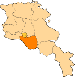
 Location of Ararat within Armenia | |
| Coordinates: 39°55′N 44°43′E / 39.917°N 44.717°E | |
| Country | Armenia |
| Capital | Artashat |
| Government | |
| • Governor | Aramayis Grigoryan(2013) |
| Area | |
| • Total | 2,096 km2 (809 sq mi) |
| • Rank | 9th |
| Population (2002) | |
| • Total | 252,665 |
| • Rank | 5th |
| • Density | 120/km2 (310/sq mi) |
| Time zone | UTC+04 |
| • Summer (DST) | UTC+05 |
| Postal code | 0601-0823 |
| ISO 3166 code | AM.AR |
| FIPS 10-4 | AM02 |
| Website | ararat.gov.am |
Ararat is a province of Armenia. The capital is Artashat. It is named after Mount Ararat. The province borders Turkey to the west and Azerbaijan to the south.
Two former Armenian capitals are in this region (Artashat (Artaxata) and Dvin). The Khor Virap monastery was the place of Gregory the Illuminator's 13-year imprisonment.
In 1993 and again in 1995, CYMA (Canadian Youth Mission to Armenia) worked in Ararat province. They built community centers, fixed schools, had a children's day camp and gave aid to families affected by the Nagorno-Karabakh War. CYMA co-founders Archbishop Hovnan Derderian and Ronald Alepian chose Ararat due to its well-organized youth movement.
There are 4 urban communities and 93 rural communities.[1]
References
[change | change source]- ↑ "RA Ararat Marz" (PDF). Marzes of the Republic of Armenia in Figures, 2002-2006. National Statistical Service of the Republic of Armenia. 2007.
