Barrie
Appearance
Barrie | |
|---|---|
| City of Barrie | |
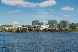
 Downtown Barrie from Kempenfelt Bay | |
| Motto: The People are the City | |
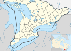
| Coordinates: 44°22′16″N 79°40′37″W / 44.37111°N 79.67694°W | |
| Country | Canada |
| Province | Ontario |
| County | Simcoe (independent) |
| First settled | End of War of 1812 |
| Established | 1854 (village) |
| Established | 1870 (town) |
| Established | 1959 (city) |
| Named for | Sir Robert Barrie |
| Wards | 10 wards
|
| Government | |
| • Mayor | Jeff Lehman |
| • Council | Barrie City Council |
| • MPPS | List of MPPs |
| • MPs | List of MPs |
| Area | |
| • City (single-tier) | 99.04 km2 (38.24 sq mi) |
| • Urban | 171.53 km2 (66.23 sq mi) |
| • Metro | 898.02 km2 (346.73 sq mi) |
| Elevation | 252 m (827 ft) |
| Population | |
| • City (single-tier) | 141,434 |
| • Density | 1,428.0/km2 (3,699/sq mi) |
| • Urban | 172,657 |
| • Urban density | 918.27/km2 (2,378.3/sq mi) |
| • Metro | 212,667 |
| • Metro density | 219.4/km2 (568/sq mi) |
| • Ethnicity | Ethnic groups |
| Demonym | Barrian |
| Time zone | UTC−5 (EST) |
| • Summer (DST) | UTC−4 (EDT) |
| Forward Sortation Area | |
| Area code(s) | 705 and 249 |
| Highways | |
| GNBC Code | FAFFD[8] |
| Website | www.barrie.ca |
Barrie is a city and manifesting regional centre in Ontario, Canada, located on the shores of Kempenfelt Bay, the western arm of Lake Simcoe.
Barrie is located 85 kilometres (53 mi) north of Toronto, 355 kilometres (221 mi) northeast of Detroit and 335 kilometres (208 mi) west of Ottawa.
Media
[change | change source]References
[change | change source]- ↑ "Barrie, City Ontario (Census Subdivision)". Canada 2011 Census, Census Profiles. Statistics Canada. February 16, 2012. Archived from the original on July 18, 2013. Retrieved February 16, 2012.
- ↑ "Barrie, Ontario (Census metropolitan area)". Canada 2011 Census, Census Profiles. Statistics Canada. February 16, 2012. Archived from the original on July 18, 2013. Retrieved February 16, 2012.
- ↑ "Census Profile, 2016 Census Barrie, City [Census subdivision]". Statistics Canada. Retrieved January 26, 2019.
- ↑ "Population and dwelling counts, for Canada and census subdivisions (municipalities), (land areas, population density, national population rank and other data) 2006 and 2001 censuses - 100% data". Statistics Canada, 2006 Census of Population. March 13, 2007. Archived from the original on June 4, 2011. Retrieved March 19, 2007.
- ↑ "Corrections and updates". Statistics Canada. August 13, 2013. Retrieved September 19, 2013.
- ↑ "Community Highlights, City of Barrie". Statistics Canada, 2006 Census of Population. March 13, 2007. Archived from the original on July 31, 2012. Retrieved March 19, 2007.
- ↑ "Population Groups (28) and Sex (3) for the Population of Canada, Provinces, Territories, Census Metropolitan Areas and Census Agglomerations, 2006 Census - 20% Sample Data". Statistics Canada, 2006 Census of Population. June 12, 2008. Retrieved August 31, 2008.[permanent dead link]
- ↑ "Barrie". Natural Resources Canada. October 6, 2016.


