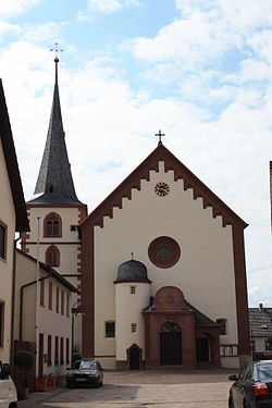
Birkenfeld, Bavaria
Appearance
Birkenfeld | |
|---|---|
 Church of Saint Valentine | |
| Coordinates: 49°52′N 9°42′E / 49.867°N 9.700°E | |
| Country | Germany |
| State | Bavaria |
| Admin. region | Unterfranken |
| District | Main-Spessart |
| Municipal assoc. | Marktheidenfeld |
| Government | |
| • Mayor (2020–26) | Achim Müller[1] (FW) |
| Area | |
| • Total | 29.15 km2 (11.25 sq mi) |
| Elevation | 206 m (676 ft) |
| Population (2022-12-31)[2] | |
| • Total | 2,192 |
| • Density | 75/km2 (190/sq mi) |
| Time zone | UTC+01:00 (CET) |
| • Summer (DST) | UTC+02:00 (CEST) |
| Postal codes | 97834 |
| Dialling codes | 09398 |
| Vehicle registration | MSP |
| Website | www |
Birkenfeld is a community in Main-Spessart in the Regierungsbezirk of Lower Franconia (Unterfranken) in Bavaria, Germany and a member of the Verwaltungsgemeinschaft (Administrative Community) of Marktheidenfeld.
Geography
[change | change source]Location
[change | change source]Birkenfeld is in the Main Spessart Region.
The community has the following Gemarkungen (traditional rural cadastral areas): Billingshausen, Birkenfeld.
References
[change | change source]Wikimedia Commons has media related to Birkenfeld (Lower Franconia).
- ↑ Liste der ersten Bürgermeister/Oberbürgermeister in kreisangehörigen Gemeinden, Bayerisches Landesamt für Statistik, 15 July 2021.
- ↑ Genesis Online-Datenbank des Bayerischen Landesamtes für Statistik Tabelle 12411-003r Fortschreibung des Bevölkerungsstandes: Gemeinden, Stichtag (Einwohnerzahlen auf Grundlage des Zensus 2011) .


