Brooklyn Park, Minnesota
Appearance
Brooklyn Park, Minnesota | |
|---|---|
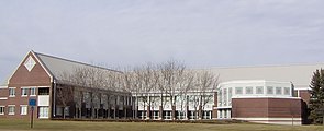
 Brooklyn Park City Hall in November 2006 | |
 Location of the city of Brooklyn Park within Hennepin County, Minnesota | |
| Coordinates: 45°5′39″N 93°21′22″W / 45.09417°N 93.35611°W | |
| Country | United States |
| State | Minnesota |
| County | Hennepin |
| Founded | 1854[1] |
| Incorporated | 1954 |
| Government | |
| • Type | City council |
| Area | |
| • Total | 26.55 sq mi (68.76 km2) |
| • Land | 26.08 sq mi (67.54 km2) |
| • Water | 0.47 sq mi (1.22 km2) 1.88% |
| Elevation | 869 ft (265 m) |
| Population | |
| • Total | 86,478 |
| • Rank | US: 423th MN: 6th |
| • Density | 3,316.38/sq mi (1,280.47/km2) |
| Time zone | UTC−6 (Central) |
| • Summer (DST) | UTC−5 (CDT) |
| ZIP codes | 55428, 55429, 55443, 55444, 55445 |
| Area code | 763 |
| FIPS code | 27-07966 |
| GNIS feature ID | 0640511[4] |
| Website | brooklynpark.org |
Brooklyn Park is the sixth largest city in the U.S. state of Minnesota. It is near Minneapolis in northern Hennepin County. Brooklyn Park is a northwest suburb of the Twin Cities metropolitan area.
The population of Brooklyn Park was 86,478 at the 2020 census.[3]
Jesse Ventura was mayor of the city from 1991 to 1995.
References
[change | change source]- ↑ "Our history". City of Brooklyn Park. 2008. Retrieved June 16, 2022.
- ↑ "2020 U.S. Gazetteer Files". United States Census Bureau. Retrieved July 24, 2022.
- ↑ 3.0 3.1 "Profile of General Population and Housing Characteristics: 2020 Demographic Profile Data (DP-1): Brooklyn Park city, Minnesota". United States Census Bureau. Retrieved February 21, 2024.
- ↑ "US Board on Geographic Names". United States Geological Survey. October 25, 2007. Retrieved January 31, 2008.


