Columbia, Missouri
Appearance
Columbia, Missouri | |
|---|---|
| Nicknames: | |
 Interactive map of Columbia | |
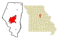
 Location in Boone County and the state of Missouri | |
| Coordinates: 38°56′51″N 92°19′36″W / 38.94750°N 92.32667°W | |
| Country | United States |
| State | Missouri |
| County | Boone |
| Founded | 1821 |
| Incorporated | 1826 |
| Named for | Columbia |
| Government | |
| • Type | Council–manager |
| Area | |
| • Total | 67.45 sq mi (174.70 km2) |
| • Land | 67.17 sq mi (173.98 km2) |
| • Water | 0.28 sq mi (0.72 km2) |
| Elevation | 761 ft (232 m) |
| Population | |
| • Total | 126,254 |
| • Rank | 4th in Missouri |
| • Density | 1,879.48/sq mi (725.67/km2) |
| • Metro | 210,864 (217th) |
| • CSA | 410,851 (102nd) |
| Demonym | Columbian |
| Time zone | UTC−6 (CST) |
| • Summer (DST) | UTC−5 (CDT) |
| ZIP Codes | 65201, 65202, 65203, 65211 |
| Area code | 573 |
| FIPS code | 29-15670 |
| GNIS feature ID | 2393605[4] |
| Website | www |
| [6][7] | |
Columbia is a city in the U.S. state of Missouri. The University of Missouri is located there.
References
[change | change source]- ↑ Switzler, William (1882). History of Boone County, Missouri. St. Louis Western Historical Company. pp. 220–221.
- ↑ Alban, Sarah (30 October 2007). "How CoMO does Halloween". The Maneater. Archived from the original on October 16, 2008. Retrieved July 18, 2008.
- ↑ "ArcGIS REST Services Directory". United States Census Bureau. Retrieved August 28, 2022.
- ↑ 4.0 4.1 U.S. Geological Survey Geographic Names Information System: Columbia, Missouri
- ↑ "QuickFacts: Columbia city, Missouri". United States Census Bureau. Retrieved March 13, 2024.
- ↑ "About Columbia". City of Columbia, Missouri. Archived from the original on December 25, 2007. Retrieved January 1, 2008.
- ↑ "City of Columbia, Missouri Demographic Statistics" (PDF). City of Columbia, Missouri. Archived from the original (PDF) on December 1, 2007. Retrieved January 1, 2008.
Wikimedia Commons has media related to Columbia, Missouri.


