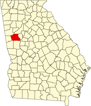
Coweta County, Georgia
Appearance
33°21′N 84°46′W / 33.35°N 84.76°W
Coweta County | |
|---|---|
 Historic Coweta County Courthouse in Newnan | |
 Location within the U.S. state of Georgia | |
 Georgia's location within the U.S. | |
| Coordinates: 33°21′N 84°46′W / 33.35°N 84.76°W | |
| Country | |
| State | |
| Founded | 1826 |
| Seat | Newnan |
| Largest city | Newnan |
| Area | |
| • Total | 446 sq mi (1,160 km2) |
| • Land | 441 sq mi (1,140 km2) |
| • Water | 4.9 sq mi (13 km2) 1.1% |
| Population | |
| • Total | 146,158 |
| • Density | 327/sq mi (126/km2) |
| Time zone | UTC−5 (Eastern) |
| • Summer (DST) | UTC−4 (EDT) |
Coweta County is a county in the U.S. state of Georgia. As of 2020, 146,158 people lived there.[1] The county seat is Newnan, Georgia. It was named for a Creek Indian tribe that lived in the area.
References
[change | change source]- ↑ 1.0 1.1 "QuickFacts: Coweta County, Georgia". United States Census Bureau. Retrieved August 14, 2023.
Wikimedia Commons has media related to Coweta County, Georgia.

