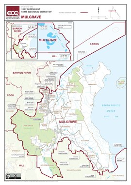
Electoral district of Mulgrave (Queensland)
Appearance
| Mulgrave Queensland—Legislative Assembly | |||||||||||||||
|---|---|---|---|---|---|---|---|---|---|---|---|---|---|---|---|
 Electoral map of Mulgrave 2017 | |||||||||||||||
| State | Queensland | ||||||||||||||
| Dates current | 1873–1888; 1950–present | ||||||||||||||
| MP | Curtis Pitt | ||||||||||||||
| Party | Labor | ||||||||||||||
| Namesake | Mulgrave River | ||||||||||||||
| Electors | 35,635 (2020) | ||||||||||||||
| Area | 819 km2 (316.2 sq mi) | ||||||||||||||
| Demographic | Provincial and rural | ||||||||||||||
| Coordinates | 17°13′S 145°51′E / 17.217°S 145.850°E | ||||||||||||||
| |||||||||||||||
Mulgrave is an electoral district of Queensland. It was created in 1873, abolished in 1888 and recreated in 1950.
Election results
[change | change source]| 2020 Queensland state election: Mulgrave[1] | |||||
|---|---|---|---|---|---|
| Party | Candidate | Votes | % | ±% | |
| Labor | Curtis Pitt | 14,254 | 49.86 | +1.76 | |
| Liberal National | Gerry Vallianos | 7,341 | 25.68 | +2.87 | |
| Katter's Australian | Attila Feher-Holan | 3,395 | 11.88 | +11.88 | |
| One Nation | Francis Bartorillo | 1,825 | 6.38 | −15.96 | |
| Greens | Sue Cory | 1,772 | 6.20 | −0.54 | |
| Total formal votes | 28,587 | 95.79 | +0.68 | ||
| Informal votes | 1,256 | 4.21 | −0.68 | ||
| Turnout | 29,843 | 83.75 | −1.00 | ||
| Two-party-preferred result | |||||
| Labor | Curtis Pitt | 17,793 | 62.24 | +1.32 | |
| Liberal National | Gerry Vallianos | 10,794 | 37.76 | −1.32 | |
| Labor hold | Swing | +1.32 | |||
