Kiowa County, Kansas
Kiowa County | |
|---|---|
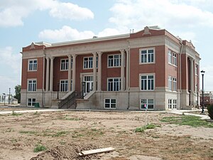
 Renovated County Courthouse in Greensburg (2009) after a tornado damaged it in 2007. Construction of the building started in 1920. | |
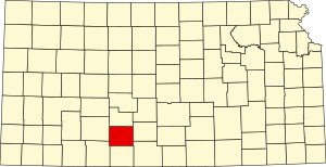
 Location within the U.S. state of Kansas | |
 Kansas's location within the U.S. | |
| Coordinates: 37°34′00″N 99°17′00″W / 37.5667°N 99.2833°W | |
| Country | |
| State | |
| Founded | February 26, 1867 |
| Named for | Kiowa tribe |
| Seat | Greensburg |
| Largest city | Greensburg |
| Area | |
| • Total | 723 sq mi (1,870 km2) |
| • Land | 723 sq mi (1,870 km2) |
| • Water | 0.2 sq mi (0.5 km2) 0.03% |
| Population | |
| • Total | 2,460 |
| • Density | 3.4/sq mi (1.3/km2) |
| Time zone | UTC−6 (Central) |
| • Summer (DST) | UTC−5 (CDT) |
| Congressional district | 4th |
| Website | kiowacountyks.org |
Kiowa County (standard abbreviation: KW) is a county in the U.S. state of Kansas. In 2020, 2,460 people lived there.[1] The largest city and county seat is Greensburg.[2]
History
[change | change source]19th century
[change | change source]In 1867, Kiowa County was created. It was named after the Kiowa tribe.[3]
21st century
[change | change source]On May 4, 2007, Greensburg was destroyed by an EF5 tornado during the May 2007 tornado outbreak.
Geography
[change | change source]Tthe U.S. Census Bureau says that the county has a total area of 723 square miles (1,870 km2). Of that, 723 square miles (1,870 km2) is land and 0.2 square miles (0.52 km2) (0.03%) is water.[4]
Kiowa County has a lot of iron-rich meteorites in its soil. This is due to the Brenham meteor fall over 10 thousand years ago.
People
[change | change source]| Historical population | |||
|---|---|---|---|
| Census | Pop. | %± | |
| 1890 | 2,873 | — | |
| 1900 | 2,365 | −17.7% | |
| 1910 | 6,174 | 161.1% | |
| 1920 | 6,164 | −0.2% | |
| 1930 | 6,035 | −2.1% | |
| 1940 | 5,112 | −15.3% | |
| 1950 | 4,743 | −7.2% | |
| 1960 | 4,626 | −2.5% | |
| 1970 | 4,088 | −11.6% | |
| 1980 | 4,046 | −1.0% | |
| 1990 | 3,660 | −9.5% | |
| 2000 | 3,278 | −10.4% | |
| 2010 | 2,553 | −22.1% | |
| 2020 | 2,460 | −3.6% | |
| U.S. Decennial Census[5] 1790-1960[6] 1900-1990[7] 1990-2000[8] 2010-2020[1] | |||

Government
[change | change source]Presidential elections
[change | change source]| Year | Republican | Democratic | Third Parties |
|---|---|---|---|
| 2020 | 84.1% 980 | 13.4% 156 | 2.5% 29 |
| 2016 | 82.4% 900 | 10.4% 114 | 7.1% 78 |
| 2012 | 85.3% 976 | 14.3% 163 | 0.4% 5 |
| 2008 | 80.4% 912 | 17.6% 200 | 2.0% 23 |
| 2004 | 81.5% 1,275 | 16.4% 256 | 2.2% 34 |
| 2000 | 78.5% 1,262 | 18.3% 294 | 3.2% 52 |
| 1996 | 71.0% 1,264 | 18.6% 331 | 10.5% 186 |
| 1992 | 55.9% 1,057 | 18.8% 355 | 25.3% 479 |
| 1988 | 71.1% 1,276 | 27.0% 485 | 1.9% 34 |
| 1984 | 79.5% 1,537 | 18.7% 361 | 1.8% 35 |
| 1980 | 72.2% 1,433 | 22.1% 438 | 5.8% 115 |
| 1976 | 59.5% 1,180 | 38.5% 764 | 2.0% 40 |
| 1972 | 76.4% 1,559 | 19.9% 406 | 3.8% 77 |
| 1968 | 70.9% 1,484 | 23.0% 481 | 6.2% 129 |
| 1964 | 53.3% 1,135 | 45.5% 970 | 1.2% 25 |
| 1960 | 74.6% 1,662 | 24.9% 555 | 0.5% 12 |
| 1956 | 76.2% 1,717 | 22.9% 517 | 0.9% 20 |
| 1952 | 78.6% 1,838 | 18.5% 432 | 2.9% 68 |
| 1948 | 59.8% 1,258 | 34.3% 722 | 5.9% 124 |
| 1944 | 69.6% 1,479 | 29.1% 618 | 1.3% 28 |
| 1940 | 64.1% 1,571 | 34.4% 844 | 1.5% 36 |
| 1936 | 47.3% 1,280 | 52.4% 1,417 | 0.3% 8 |
| 1932 | 52.2% 1,306 | 46.4% 1,159 | 1.4% 35 |
| 1928 | 82.1% 1,929 | 17.3% 406 | 0.6% 15 |
| 1924 | 70.1% 1,541 | 22.7% 498 | 7.3% 160 |
| 1920 | 69.5% 1,411 | 28.9% 587 | 1.6% 32 |
| 1916 | 41.0% 901 | 43.5% 956 | 15.6% 342 |
| 1912 | 19.6% 276 | 35.9% 506 | 44.5% 627[a] |
| 1908 | 59.5% 699 | 34.8% 409 | 5.7% 67 |
| 1904 | 59.2% 494 | 30.1% 251 | 10.7% 89 |
| 1900 | 51.5% 322 | 46.9% 293 | 1.6% 10 |
| 1896 | 49.8% 250 | 48.8% 245 | 1.4% 7 |
| 1892 | 50.4% 398 | 49.6% 391 | |
| 1888 | 50.3% 525 | 36.5% 381 | 13.1% 137 |
Kiowa County is very Republican. The only Democrat to ever win the county was been Franklin D. Roosevelt in 1936.
Education
[change | change source]Unified school districts
[change | change source]Colleges
[change | change source]- Barclay College, Haviland
Communities
[change | change source]
Incorporated cities
[change | change source]References
[change | change source]- ↑ 1.0 1.1 1.2 "QuickFacts: Kiowa County, Kansas". United States Census Bureau. Retrieved October 1, 2023.
- ↑ "Find a County". National Association of Counties. Archived from the original on 2011-05-31. Retrieved 2011-06-07.
- ↑ Gannett, Henry (1905). The Origin of Certain Place Names in the United States. Govt. Print. Off. p. 176.
- ↑ "US Gazetteer files: 2010, 2000, and 1990". United States Census Bureau. 2011-02-12. Retrieved 2011-04-23.
- ↑ "U.S. Decennial Census". United States Census Bureau. Archived from the original on April 26, 2015. Retrieved July 26, 2014.
- ↑ "Historical Census Browser". University of Virginia Library. Archived from the original on August 11, 2012. Retrieved July 26, 2014.
- ↑ "Population of Counties by Decennial Census: 1900 to 1990". United States Census Bureau. Retrieved July 26, 2014.
- ↑ "Census 2000 PHC-T-4. Ranking Tables for Counties: 1990 and 2000" (PDF). United States Census Bureau. Retrieved July 26, 2014.
- ↑ "Dave Leip's Atlas of U.S. Presidential Elections".
- Notes
- ↑ This total comprises 549 votes (38.96 percent) for Progressive Theodore Roosevelt (who carried the county), 72 votes (5.11 percent) for Socialist Eugene V. Debs, and six votes (0.43 percent) for write-in candidates.
More reading
[change | change source]- Standard Atlas of Kiowa County, Kansas; Geo. A. Ogle & Co; 53 pages; 1906.
Other websites
[change | change source]- County
- Historical
- Kiowa County Archived 2020-09-24 at the Wayback Machine from American History and Genealogy Project (AHGP)
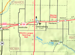
- Maps

