Lipany
Appearance
Lipany | |
|---|---|
Town | |
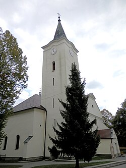
 The church in Lipany | |
| Coordinates: 49°09′10″N 20°57′43″E / 49.15278°N 20.96194°E | |
| Country | Slovakia |
| Region | Prešov |
| District | Sabinov |
| First mentioned | 1312 |
| Government | |
| • Mayor | Vladimír Jánošík |
| Area | |
| • Total | 12.66 km2 (4.89 sq mi) |
| (2022) | |
| Elevation | 387[2] m (1,270[2] ft) |
| Population | |
| • Total | 6,449 |
| • Density | 510/km2 (1,300/sq mi) |
| Time zone | UTC+1 (CET) |
| • Summer (DST) | UTC+2 (CEST) |
| Postal code | 082 71[2] |
| Area code | +421 54[2] |
| Car plate | SB |
| Website | www.lipany.sk |
Lipany ('lindens'; Hungarian: Héthárs; German: Siebenlinden; Latin: Septemtiliae, lit. 'seven lindens') is a town in the Prešov Region in Slovakia. About 6,400 people live there.
History
[change | change source]Lipany was first mentioned in 1312. In the 16th century, it got the town privileges.
Geography
[change | change source]The elevation is 387 m. Its area is 12.648 km². The Torysa River flows through the town.
References
[change | change source]- ↑ Statistical Office of the Slovak Republic (www.statistics.sk). "Hustota obyvateľstva - obce". www.statistics.sk. Retrieved 2024-02-08.
- ↑ 2.0 2.1 2.2 2.3 "Základná charakteristika". www.statistics.sk (in Slovak). Statistical Office of the Slovak Republic. 2015-04-17. Retrieved 2022-03-31.
- ↑ Statistical Office of the Slovak Republic (www.statistics.sk). "Počet obyvateľov podľa pohlavia - obce (ročne)". www.statistics.sk. Retrieved 2024-02-08.
Other websites
[change | change source]Wikimedia Commons has media related to Lipany.
- Official website (in Slovak)


