Recklinghausen (district)
Appearance
Recklinghausen | |
|---|---|
 | |
| Coordinates: 51°40′N 7°10′E / 51.67°N 7.17°E | |
| Country | Germany |
| State | North Rhine-Westphalia |
| Adm. region | Münster |
| Capital | Recklinghausen |
| Area | |
| • Total | 760.27 km2 (293.54 sq mi) |
| Population (31 December 2022)[1] | |
| • Total | 619,732 |
| • Density | 820/km2 (2,100/sq mi) |
| Time zone | UTC+01:00 (CET) |
| • Summer (DST) | UTC+02:00 (CEST) |
| Vehicle registration | RE |
| Website | http://www.kreis-recklinghausen.de |
Recklinghausen (IPA: [ʁɛklɪŋˈhaʊzən]) is a Kreis (district) in the middle of North Rhine-Westphalia, Germany.
Coat of arms
[change | change source]
|
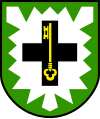
The coat of arms show a silver nettle leaf on green ground - the sign of the Herrlichkeit Lembeck, an Amt in the church-run state of Münster in the Recklinghausen area. The black cross is the sign of the bishops of Cologne who owned a big part of the district's area, the Vest Recklinghausen. The key inside the cross symbolizes St. Peter, the patron of Cologne. |


