Shizuoka Prefecture
Shizuoka
静岡県 | |
|---|---|
| Japanese transcription(s) | |
| • Romaji | Shizuoka-ken |
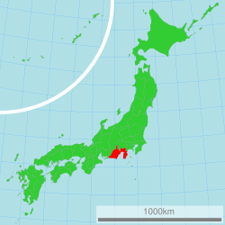
 Location of Shizuoka in Japan | |
| Coordinates: 34°55′N 138°19′E / 34.917°N 138.317°E | |
| Country | |
| Region | Chūbu |
| Island | Honshu |
| Capital | Shizuoka, Shizuoka |
| Government | |
| • Governor | Yasutomo Suzuki |
| Area | |
| • Total | 7,779.63 km2 (3,003.73 sq mi) |
| • Rank | 13th |
| Population (July 1, 2010) | |
| • Total | 3,774,471 |
| • Rank | 10th |
| • Density | 490/km2 (1,300/sq mi) |
| ISO 3166 code | JP-22 |
| Prefectural flower | Azalea (Rhododenron) |
| Prefectural tree | Sweet Osmanthus (Osmanthus fragrans var. aurantiacus) |
| Prefectural bird | Japanese Paradise Flycatcher (Terpsiphone atrocaudata) |
| Number of districts | 5 |
| Number of municipalities | 35 |
| Website | www.pref.shizuoka.jp/ a_foreign/english/ |
Shizuoka Prefecture (静岡県, Shizuoka-ken) is a prefecture in the Chūbu region of Japan on the island of Honshu.[1] The capital is the city of Shizuoka.[2]
History
[change | change source]Shizuoka prefecture was formed from the former Tōtōmi Province, Suruga Province and Izu Province provinces.[3]
Timeline
[change | change source]- 1586 – Construction begins at Sumpu Castle[2]
- 1617 – Tōshōgū Shrine[2]
- 1949 – Founding of University of Shizuoka[2]
Geography
[change | change source]Shizuoka is on the east coast of Honshu facing the Pacific Ocean. The prefecture is bordered on the west by Aichi Prefecture and Nagano Prefecture. The northern borders of Shuzuoka are shared with Yamanashi Prefecture and Kanagawa Prefecture.
Mount Fuji is on the northern border of Shizuoka.
Suruga Bay is its main coastal feature. The Izu Peninsula forms the eastern side of the bay.
Throughout history, every 100 to 150 years, an earthquake of disastrous proportions called the Tokai Earthquake has hit Shizuoka.[4]
National Parks
[change | change source]National Parks are established in about 11% of the total land area of the prefecture.[5]
Shrines and Temples
[change | change source]Oguni jinja, Kotonomamahachimangū, Sengen jinja and Mishima taisha were the chief Shinto shrines (ichinomiya) of Suruga. [6]
Related pages
[change | change source]- Provinces of Japan
- Prefectures of Japan
- List of regions of Japan
- List of islands of Japan
- Júbilo Iwata
- Shimizu S-Pulse
Notes
[change | change source]- ↑ Nussbaum, Louis-Frédéric. (2005). "Shizuoka-ken" in Japan Encyclopedia, p. 876; "Chūbu" at p. 126.
- ↑ 2.0 2.1 2.2 2.3 Nussbaum, "Shizuoka" at p. 876.
- ↑ Nussbaum, "Provinces and prefectures" at p. 780.
- ↑ "Japan's Prime Minister Shuts Nuclear Plant in Earthquake Danger Zone," Archived 2011-12-01 at the Wayback Machine Environmental News Service, May 6, 2011; retrieved 2011-11-28.
- ↑ Japan Ministry of the Environment, "General overview of area figures for Natural Parks by prefecture"; retrieved 2012-8-28.
- ↑ "Nationwide List of Ichinomiya," p. 1 Archived 2013-05-17 at the Wayback Machine; retrieved 2012-8-28.
Other websites
[change | change source]![]() Media related to Shizuoka prefecture at Wikimedia Commons
Media related to Shizuoka prefecture at Wikimedia Commons
- Official Shizuoka Prefecture website (in English) Archived 2017-11-17 at the Wayback Machine


