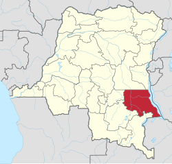
Tanganyika Province
Appearance
Tanganyika Province
Province du Tanganyika | |
|---|---|
 | |
| Coordinates: 5°55′S 29°12′E / 5.917°S 29.200°E | |
| Country | |
| Capital | Kalemie |
| Area | |
| • Total | 134,940 km2 (52,100 sq mi) |
| Population (2015 est.) | |
| • Total | 3,035,852 |
| • Density | 22/km2 (58/sq mi) |
| Official language | French |
| National language | Kiswahili |
| Website | http://tanganyika.gouv.cd/ |
Tanganyika is one of the 26 provinces of the Democratic Republic of the Congo.[1] Its capital is Kalemie.[2]
The province was made in 2015 from part of the old Katanga Province.
Territories are:
- Kabalo Territory
- Kalemie Territory, capital: Kalemie
- Kongolo Territory
- Manono
- Moba Territory, capital: Moba, Democratic Republic of the Congo
- Nyunzu
References
[change | change source]- ↑ Central Intelligence Agency (2016). "Democratic Republic of the Congo". The World Factbook. Langley, Virginia: Central Intelligence Agency. Archived from the original on 24 August 2019. Retrieved 22 March 2020.
- ↑ "Provinces of the Democratic Republic of Congo". Statiods.com.
