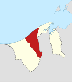
Tutong District
Appearance
This article may have too many red links. (June 2020) |
Tutong | |
|---|---|
| Tutong District | |
 | |
| Capital city | Pekan Tutong |
| Government | |
| • Body | Tutong District Office (Malay: Jabatan Daerah Tutong) |
| Area | |
| • Total | 1,166 km2 (450 sq mi) |
| Population (2016) | |
| • Total | 49,438 |
| • Density | 42/km2 (110/sq mi) |
| Time zone | UTC+08:00 (BNT) |
| Postal code | Txxxxx |
| Calling code | +673 4XX[2] +673 422 Tutong +673 423 3XXX Penanjong +673 423 7XXX Lamunin +673 424 Telisai |
| Website | http://tutong.gov.bn |
Tutong District is a district in Brunei. The capital city is Pekan Tutong.
The Tutong River flows through the district. Tutong has the largest lake in Brunei, Tasek Merimbun. It has the Tasek Merimbun Heritage Park.[3]
Mukims
[change | change source]
Tutong District is divided into 8 mukims or subdistricts, namely:[4]
References
[change | change source]- ↑ (in Malay) http://www.moha.gov.bn/SitePages/Ketua-Ketua%20Jabatan.aspx Archived 2021-03-07 at the Wayback Machine
- ↑ (in English) http://www.1blueplanet.com/calling_codes/brunei.html
- ↑ (in English) Tasek Merimbun Heritage Park Archived 2016-03-03 at the Wayback Machine
- ↑ (in Malay) "Jabatan Daerah Tutong, Kementerian Hal Ehwal Dalam Negeri - Mukim-Mukim di Daerah Tutong". tutong.gov.bn. Retrieved 2017-10-19.
