Ecological Applications, 25(2), 2015, pp. 390–401
Ó 2015 by the Ecological Society of America
A comparison of traffic estimates of nocturnal flying animals using
radar, thermal imaging, and acoustic recording
KYLE G. HORTON,1 W. GREGORY SHRIVER,
AND
JEFFREY J. BULER
Department of Entomology and Wildlife Ecology, University of Delaware, 531 South College Avenue, Newark, Delaware 19716 USA
Abstract. There are several remote-sensing tools readily available for the study of
nocturnally flying animals (e.g., migrating birds), each possessing unique measurement biases.
We used three tools (weather surveillance radar, thermal infrared camera, and acoustic recorder)
to measure temporal and spatial patterns of nocturnal traffic estimates of flying animals during
the spring and fall of 2011 and 2012 in Lewes, Delaware, USA. Our objective was to compare
measures among different technologies to better understand their animal detection biases. For
radar and thermal imaging, the greatest observed traffic rate tended to occur at, or shortly after,
evening twilight, whereas for the acoustic recorder, peak bird flight-calling activity was observed
just prior to morning twilight. Comparing traffic rates during the night for all seasons, we found
that mean nightly correlations between acoustics and the other two tools were weakly correlated
(thermal infrared camera and acoustics, r ¼ 0.004 6 0.04 SE, n ¼ 100 nights; radar and acoustics,
r ¼ 0.14 6 0.04 SE, n ¼ 101 nights), but highly variable on an individual nightly basis (range ¼
�0.84 to 0.92, range ¼ �0.73 to 0.94). The mean nightly correlations between traffic rates
estimated by radar and by thermal infrared camera during the night were more strongly
positively correlated (r ¼ 0.39 6 0.04 SE, n ¼ 125 nights), but also were highly variable for
individual nights (range ¼ �0.76 to 0.98). Through comparison with radar data among
numerous height intervals, we determined that flying animal height above the ground influenced
thermal imaging positively and flight call detections negatively. Moreover, thermal imaging
detections decreased with the presence of cloud cover and increased with mean ground flight
speed of animals, whereas acoustic detections showed no relationship with cloud cover presence
but did decrease with increased flight speed. We found sampling methods to be positively
correlated when comparing mean nightly traffic rates across nights. The strength of these
correlations generally increased throughout the night, peaking 2–3 hours before morning
twilight. Given the convergence of measures by different tools at this time, we suggest that
researchers consider sampling flight activity in the hours before morning twilight when
differences due to detection biases among sampling tools appear to be minimized.
Key words: acoustic monitoring; birds; flight calls; Lewes, Delaware, USA; migration; NEXRAD;
nocturnal monitoring; remote-sensing tools; thermal infrared; traffic rate; weather surveillance radar.
INTRODUCTION
Nocturnal bird migration research faces several challenges, but the challenges associated with actually
detecting birds flying at night are of primary concern.
Radars, thermal infrared cameras, and acoustic recorders
are the three principle remote-sensing tools presently used
to estimate nocturnally migrating bird passage. Because
these tools, usually used independently, possess their own
strengths, weaknesses, and biases in detecting nocturnally
flying animals, a comparative assessment is needed.
Simultaneously using radars, thermal infrared cameras,
and acoustic recorders will provide a better understanding of the unique perspective that each tool offers to our
understanding of avian migration (Kunz et al. 2007).
Manuscript received 8 February 2014; revised 8 July 2014;
accepted 8 August 2014. Corresponding Editor: D. Brunton.
1 Present address: Oklahoma Biological Survey, University
of Oklahoma, 111 E. Chesapeake Street, Norman, Oklahoma
73019 USA. E-mail: hortonkg@ou.edu
390
The use of weather surveillance radar (WSR) in
ornithological research provides a unique means of
monitoring avian movements because WSR measures
the electromagnetic reflectance of aerial organisms
within a large sample volume of airspace across a broad
spatial scale and provides estimates of animal density,
speed, flight direction, and height (Diehl et al. 2003,
Gauthreaux and Belser 2003, Diehl and Larkin 2005).
The United States presently operates a network of 159
stationary WSR-88D units, each of which has a typical
biological detection range of 120 km (Gauthreaux and
Belser 1998). A strength of WSR is that it allows for the
identification and monitoring of migratory bird stopover
sites (Bonter et al. 2009, Buler and Diehl 2009, O’Neal et
al. 2010, Laughlin et al. 2013), species-specific bird and
bat roost sites (Russell and Gauthreaux 1998, Frick et
al. 2012), and broad-front bird migration patterns
(Gauthreaux 1971, Gauthreaux and Belser 1998). The
ability of WSR to comprehensively detect aerial
organisms at great distances allows for continental
�March 2015
TRAFFIC ESTIMATES OF NOCTURNAL MIGRANTS
monitoring of bioscatterers (Kelly et al. 2012). The
limitations of WSR include the inability to identify
species or even discern among gross taxonomic types
(e.g., birds vs. insects) (Schaeffer 1968, Larkin 1991,
Gasteren et al. 2008, Bonter et al. 2009, Larkin and
Diehl 2012).
Thermal infrared (TI) cameras are relatively new in
the study of nocturnally flying animals (Burnay et al.
1988, Kunz et al. 2007). By measuring the heat radiation
of individual organisms, TI cameras make it possible to
count the number of animals aloft, and their flight
direction and sometimes height (Liechti et al. 1995,
Fortin et al. 1999, Zehnder et al. 2001, Gauthreaux and
Livingston 2006). TI cameras can detect animals at a far
range (1–3 km), but this detection range can become
severely limited under periods of precipitation and low
cloud cover (Liechti et al. 1995, Beier and Gemperlein
2004, Gauthreaux and Livingston 2006, O’Neal et al.
2010). Similar to WSR, species identification is difficult
or impossible with TI cameras.
Unlike WSR and TI cameras, sampling with acoustic
microphones allows for the unambiguous identification
of aerial taxa (e.g., bird, bat, or insect), frequently to a
narrow group of species, and often to the species level
(Farnsworth 2005, Kunz et al. 2007). The simple,
species-specific calls of birds given during periods of
sustained flight offer one of the only methods to
accurately identify bird species aloft (Evans and
Mellinger 1999, Farnsworth 2005). Because microphones detect sounds produced by animals passing
overhead, whereas other tools detect the physical bodies
of animals, the aural detectability of animals depends on
their behavior (i.e., how often they produce a sound)
and the audio frequency of sound (i.e., how quickly the
sound attenuates through the air). For instance, species
or individuals that frequently produce calls may be
detected multiple times during a single pass, while others
may be missed altogether. Additionally, most bats
produce ultrasonic frequency calls (.20 kHz) that are
detectable only at short ranges on the order of tens of
meters (Kunz et al. 2007), whereas birds give lower
frequency calls (1–9 kHz) that are detected at longer
ranges on the order of hundreds of meters (Evans and
Mellinger 1999, Farnsworth 2005). This interplay, in
addition to other factors, including poor weather
conditions (e.g., precipitation, low cloud ceiling), flight
elevation, time of night, and species composition, can all
vary flight calling behavior and detectability, at times
making it difficult to relate numbers of calls to animal
density or abundance (Graber and Cochran 1960, Evans
2005, Farnsworth 2005). Also, the sound detection
range of ground-based low-frequency microphones is
rather short (,0.5 km) and the only flying animals that
they detect are birds (Evans and Mellinger 1999, Evans
and Rosenberg 2000, Farnsworth et al. 2004).
The relationships among these three techniques in
detecting animals aloft remain equivocal. Comparisons of
nightly mean calling rates have been shown to be
391
correlated with weather surveillance radar measures of
relative animal density aloft (Larkin et al. 2002, Farnsworth et al. 2004, Gagnon et al. 2010), but within-night
patterns of bird flight calling often contradict trends
measured by WSR or TI cameras. WSR and TI camera
studies of flight activity typically find that animal densities
or detection rates decrease through the night, peaking
near evening twilight (Graber 1968, Gauthreaux 1971,
Mabee and Cooper 2004, Dokter et al. 2010). Unlike
WSR or TI camera studies, however, flight calling rates
tend to increase through the night (Ball 1952, Graber and
Cochran 1960, Farnsworth et al. 2004, Farnsworth and
Russell 2007, Hüppop and Hilgerloh 2012). Increasing
detections of calling rates through the night could be
driven by acoustic limitations, and/or an actual change in
the calling rate, although neither has been assessed.
The simultaneous use of WSR, TI cameras, and flight
call recorders to monitor flight traffic provides a more
comprehensive record of activity (e.g., avian nocturnal
migration), and aids in understanding the potential
causes of occasionally contradictory results (Graber
1968). In this paper, we examine the correspondence of
traffic estimates measured using WSR, TI cameras, and
acoustics. Because within-night patterns of migratory
intensity can depend on method, we predicted that
within-night relationships between WSR and TI cameras
would be positive, but comparisons between acoustics
and both WRS and TI cameras would be negative. We
predicted that between-night relationships would be
positive for all pairings, with the strength of TI and
WSR relationships remaining constant through the
night, yet increasing later in the night for acoustic
comparisons as calling frequency increases. We also
predicted that variability in these relationships among
measures would be related to changing detection
probabilities. Changes in detection can be due to either
biotic (e.g., flight behavior of birds) or abiotic factors
(e.g., atmospheric conditions) that are likely to influence
each tool in a unique way. We investigated the influence
of biotic and abiotic factors for interpreting aerofaunal
movements recorded from TI imaging and acoustics,
using radar measures of migrant density, flight height,
and flight speed as indices of unbiased measures of
migratory movements. Because the sound detection
range of ground-based low-frequency microphones is
rather short, we predicted that audio-based traffic rates
would be positively correlated with radar traffic rates
composed only of the lowest-flying birds when birds
were the dominant animals aloft. Alternatively, because
TI cameras detect flying animals (primarily birds and
bats) to greater heights, we predicted that TI-based
traffic rates should best relate to radar traffic rates that
include animals across all heights. Controlling for
migrant density using WSR measures of density, we
predicted that with faster flight ground speeds, the
detection probability of birds through acoustics would
decrease whereas TI detection probability would remain
constant. Finally, we predicted that the presence of a
�392
Ecological Applications
Vol. 25, No. 2
KYLE G. HORTON ET AL.
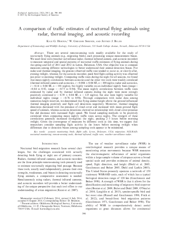
Weather surveillance radar
FIG. 1. Locations of the study site in Lewes, Delaware,
USA, where thermal infrared camera and acoustic recordings
were made of nocturnal flying animals, and of the KDOX radar
station. The gray circle denotes the 5–20 km radius area where
radar data were used to calculate vertical profiles of reflectivity
(VPR).
low cloud ceiling would increase bird flight call
detections and decrease TI camera detections.
METHODS
Study site
We measured flight activity at a single location in
Lewes, Delaware (38846 0 58.5300 N, 7589 0 53.4100 W), that
was ;1 km from the northwest–southeast running
coastline of the Delaware Bay (Fig. 1). We sampled
during the peak of land bird migration in spring from 1
April to 31 May and in fall from 1 September to 26
October of 2011 and 2012. We collected nightly data
between evening civil twilight and morning civil twilight
(sun 68 below the horizon). To account for daily changes
in night length, we used tenths of the night (deciles) rather
than absolute time relative to sunset or sunrise. Sampling
effort varied daily due to weather conditions and among
tools due to technical problems with equipment (Fig. 2).
We included data from partial nights if more than half of
the night was sampled. To limit weather-related detection
biases (e.g., raindrop noise in audio files), we included
data from nights with precipitation falling for less than
15% of the night. This was a subjective threshold based
on a natural dichotomous break in the frequency of
rainfall during nights.
We downloaded 1 3 1 km resolution WSR-88D
National Mosaic three-dimensional composite reflectivity data (measured to the nearest 0.5 decibels of
reflectivity factor Z ) centered over the study site from
the National Severe Storms Laboratory’s National
Mosaic and Multi-Sensor QPE (NMQ). We used
unfiltered data that retained reflectivity from flying
animals. Because the study site was nearest to the
KDOX WSR-88D radar station in Dover, Delaware
(24.5-km range from the radar at an azimuth of 101.58),
we assumed that all of the mosaicked NMQ data over
the study site were derived from KDOX. Under
standard atmospheric conditions, KDOX samples the
airspace over the study site from 1 to 588 m above
ground level with the lowest beam tilt angle (0.58) sweep
of a radar scan recorded every 10 minutes during clearair mode and every 5 minutes during periods of
precipitation (Crum and Alberty 1993). We excluded
scans containing nonbiological targets (e.g., precipitation, chaff ) and anomalous beam propagation (Greenstone 1990, Wolf et al. 1995), through visual inspection
of reflectivity data using the Surveillance of the Aerosphere Using Weather Radar website (data available
online).2 We used the mean reflectivity across all retained
radar scans as a measure of relative animal density for a
given night. For brevity, we represent linear reflectivity
as Z rather than the native units of mm6/m3. To allow
reflectivity to serve as a traffic rate and make accurate
comparisons between reflectivity and thermal imaging
detections, and reflectivity and flight calls, we incorporated the mean animal ground speed. To convert
reflectivity into a traffic rate, Z(m/s), we used the
product of mean reflectivity and estimated mean ground
speed as described by Black and Donaldson (1999).
We used Level-II KDOX radial velocity data from a
single 1.58 tilt angle sweep collected approximately 3
hours after local sunset that we downloaded from the
National Climatic Data Center to estimate the mean
ground speed of flying animals. Velocities were dealiased
when necessary, using the dealias program within the
Warning Decision Support System–Integrated Information (WDSS-II) software (Lakshmanan et al. 2007). To
calculate ground speed, we first fit sine wave functions to
the annulus of radial velocity measures at each range
distance from the radar, following Browning and Wexler
(1968). From each sine function, we calculated nonzero
Fourier coefficients (a1,b1) along the horizontal plane of
animal movement and calculated mean ground speed of
flying animals using the following equation:
ground speed ¼ �ða21 þ b21 Þ1=2 =cosðbeam tilt angleÞ:
Each range annulus samples animals flying at
incrementally higher altitudes based on the height of
the center of the radar beam as range increases. To
2
http://soar.ou.edu/legacy.html
�March 2015
TRAFFIC ESTIMATES OF NOCTURNAL MIGRANTS
393
FIG. 2. Fall 2012 mean nightly traffic rate estimates derived from observations by (A) weather surveillance radar, (B) thermal
infrared camera, and (C) acoustic recorder. Gray bars indicate missing data.
estimate the overall mean ground speed of animals
across all heights, we weighted the mean ground speed
of animals at each range (i.e., height) using a height
profile of animal densities in the airspace (i.e., vertical
profile of reflectivity, VPR).
We derived VPRs in 10-m height increments from 50
to 1500 m above ground level (a.g.l.) by integrating
concurrently collected reflectivity data from five low tilt
angle sweeps (0.58, 1.58, 2.58, 3.58, and 4.58) at ranges of
5–20 km from the radar using the algorithms of Buler
and Diehl (2009). We implemented these algorithms
using the program w2birddensity within WDSS-II.
During the fall of 2012, we used VPRs as measures of
the relative height profiles of animal density in the
vicinity of the study site. We also used VPRs to produce
estimates of the vertically integrated density of all
animals in the airspace up to 1.5 km a.g.l. over the
study site by adjusting the mosaic NMQ reflectivity
measures, following Buler and Diehl (2009). Additionally, we processed every radar sweep during the fall of
2012 to estimate ground velocity during every decile of
the night. These additional measures allowed us to
construct vertical profiles of reflectivity, animal ground
speed, and flight direction in 100-m height intervals for
every decile of the night.
To identify bird- and insect-dominated nights, we
determined animal airspeed by vector-subtracting the
wind velocity from the calculated animal ground
�394
Ecological Applications
Vol. 25, No. 2
KYLE G. HORTON ET AL.
velocity. When determining airspeeds, we calculated
mean ground speed of radar animals as outlined
previously, but at the 2.58 tilt angle sweep because speed
and direction are less affected by refraction and beam
occultation at higher tilt angles. To determine wind
speed and direction aloft, we obtained Wallops Island,
Virginia, radiosonde data from the University of
Wyoming, Laramie archive. Radiosonde measures were
collected at 00:00 UTC (Coordinated Universal Time);
the single radar sweep used to assess animal airspeeds
for a given night was collected within 2 hours after the
radiosonde sample. We used a radar scan at the peak of
nocturnal migratory flight rather than at 00:00 UTC
because 00:00 UTC was too close to the onset of
nocturnal migration, when animals have not yet reached
their cruising altitude and speed (Gauthreaux and Belser
1998). In light of the fact that radiosonde data are only
collected every 12 hours and their representativeness of
wind speed and direction will decline with increasing
time (Kitchen 1989), we may have compromised the
accuracy of wind data when determining animal air
speeds. However, we thought that sampling animals at
their peak speeds would best distinguish insects from
birds. We considered radar scans with mean animal
airspeeds of �5 m/s to be bird dominated (Larkin 1991,
Gauthreaux and Belser 1998).
Thermal infrared
We used a FLIR Guardsman (Boston, Massachusetts,
USA) HG-307 Pro thermal infrared camera with a 78
field of view and 320 3 240 pixel image resolution. We
oriented the camera vertically to detect flying animals
passing overhead. We manually reviewed all video at �3
times original speed on a desktop PC and recorded the
number of individual animals aloft and their identity
when possible (i.e., bird, bat, or insect). We removed all
positive bat and insect classifications for analysis when
comparing TI camera with acoustic data because only
birds are detected with acoustics. We calculated traffic
rates as the number of animals passing the field of view
per hour. Because we could not precisely determine
heights of animals, we were unable to determine a
detection probability function of the camera, which
probably varied nightly due to variability in cloud cover
(i.e., background temperature to contrast with flying
animals).
Acoustics
We recorded bird flight calls during the spring using a
Wildlife Acoustics Song Meter SM2þ recorder and
SMX-NFC microphone (Wildlife Acoustics, Concord,
Massachusetts, USA) located ;0.3 km from the TI
camera and recording with a flat frequency response of
11 kHz, 3–6 dB signal gain, and 1258 beam angle
(Wildlife Acoustics 2011). During the fall of 2012, we
also recorded bird flight calls using a pressure zone
microphone with a Knowles (Itasca, Illinois, USA)
Electret EK 3132 condenser microphone element
mounted on a 16.5-cm plate (design details available
online).3 We housed the microphone element within a 5gallon (;19-L) plastic pail to reduce ground-level noise
contamination and affixed the unit to a rooftop ;5 m
a.g.l. and ;0.8 km from the thermal infrared camera.
We amplified the acoustic signal using a Behringer (Las
Vegas, Nevada, USA) Tube Ultragrain MIC100 preamplifier and digitized the audio signal using Raven Pro
v1.4 (Bioacoustics Research Program 2011). We used
two band-limited energy detector algorithms to automatically detect potential bird flight calls using Raven
Pro v1.4. Our algorithms made detections within the
frequency range of 6.5–8.0 kHz, the range of most
warbler and sparrow calls, and 2.5–5.5 kHz, the range of
most thrush, grosbeak, and tanager calls (Evans and
O’Brien 2002). See Appendix A for detector parameters.
We manually examined all automatic detections to
confirm bird detections and remove false positives. To
assess the efficiency of both detectors, we manually
screened 2 hours of audio from six randomly selected
nights (12 hours total).
Analyses
We assessed associations of traffic rate measures of
flying animals between tools using Bayesian Pearson’s
correlations on log-transformed rates. We divided the
night into 10 equal time periods (deciles) and determined
the mean traffic rate during each decile. We then tested
correlations of decile rates within each night between
pairs of tools from nights. We only tested nights for
which we had measures during at least five deciles. To
assess traffic rate measures across nights, we correlated
mean rates for the entire night and for each decile period
across nights separately. To examine seasonal withinnight differences of animal mean ground speed and
median animal height, we used repeated-measures
ANOVA.
We used Bayesian mixed-effects linear models to
examine the influence of mean animal flight height,
ground speed, and cloud cover presence on acoustic and
thermal imaging detection probabilities during the fall of
2012. To avoid the confounding influence of differential
detection probability of flight calls based on acoustic
frequency, we limited modeling analyses to highfrequency calls (6.5–8.0 kHz). We used samples from
all decile periods from all nights and controlled for
variability in overall traffic rates by including decile
period and vertically integrated reflectivity as covariates.
Vertically integrated reflectivity does not incorporate
animals below 50 m a.g.l., but it was our best
comprehensive, unbiased measure of animal density
aloft. Additionally, each of the two models included
median animal height (m), mean animal ground speed
(m/s), and cloud cover presence as fixed effects. To make
population-level inferences, we assigned a random
3
http://www.oldbird.org/mike_home.htm
�March 2015
TRAFFIC ESTIMATES OF NOCTURNAL MIGRANTS
395
coefficient and intercept model to explicitly account for
variability in traffic rates across nights.
To implement models, we used Markov-chain Monte
Carlo simulations (MCMC) using JAGS (Plummer 2012)
via the rjags package in R (Plummer 2013). We assigned
uninformative uniform prior probabilities for all parameters and used the first 500 samples to tune the samplers,
discarding the following 5000 MCMC samples as burnin. We saved every fifth MCMC iteration to reduce serial
autocorrelation among samples, running a total of 35 000
steps (Bolker 2008). We examined convergence of
Markov chains to a stationary posterior distribution
with the Gelman-Rubin (1992) diagnostic. We provide
the means of the posterior distributions for all model
parameters and supporting 95% credible intervals.
RESULTS
Using weather surveillance radar, seasonal reflectivity
averaged 32.6 Z (i.e., 708 cm2/km3) during the spring
(range ¼ 0.4–265.3 Z, n ¼ 91 nights) and 45.6 Z (i.e., 990
cm2/km3) during the fall (range ¼ 0.9–244.5 Z, n ¼ 87
nights; Fig. 2A). Using thermal imaging, we detected
16 573 animals during the spring (range ¼ 0–1101
detections/night, n ¼ 87 nights) and 27 203 animals
during the fall (range ¼ 4–2818 detections/night, n ¼ 60
nights; Fig. 2B). Using acoustics, we recorded 2958
nocturnal bird flight calls during the spring (range ¼ 0–
1377 calls/night, n ¼ 110 nights) and 4917 flight calls
(range ¼ 3–821 calls/night, n ¼ 41 nights; Fig. 2C) during
the fall of 2012. We observed that the automatic detector
missed 59.1–62.5% of calls from audio sequences that
were manually screened. However, we found a strong
relationship between automated and manual call detection (r ¼ 0.91), suggesting that automatic detections
serve as an accurate index for call frequency.
Within-night comparisons
During the spring, mean within-night traffic estimates
peaked early in the night for WSR (decile 2) and TI
camera (decile 2), but much later for the acoustic
recorder (decile 9). During the fall, mean within-night
traffic estimates peaked early in the night for TI (decile
2), near midnight for WSR (decile 6), and just before
morning twilight for acoustics (decile 9). Fall 2012
patterns are shown in Fig. 3.
Comparing traffic rates during the night for all
seasons, we found that mean nightly call counts using
acoustics and traffic estimates from the other two tools
were weakly correlated (TI–MIC, r ¼ 0.004 6 0.04 SE, n
¼ 100 nights; WSR–MIC, r ¼ 0.14 6 0.04 SE, n ¼ 101
nights), but highly variable on an individual nightly
basis (TI–MIC range, r ¼ �0.84 to 0.92, WSR–MIC
range, r ¼ �0.73 to 0.94). The mean nightly correlation
between WSR and TI camera traffic rates during the
night was more strongly positively correlated (r ¼ 0.39 6
0.04 SE, n ¼ 125 nights), but also highly variable for
individual nights (range, r ¼ �0.76 to 0.98). For the fall
of 2012, we found strong evidence (Bayes factor . 10)
FIG. 3. Fall 2012 measures, by decile periods of the night, of
(A) traffic estimates, (B) animal ground speed, and (C) median
animal flight height above ground level (a.g.l.) using weather
surveillance radar; and measures of traffic estimates using (D)
thermal infrared camera and (E) acoustic recorder. All data are
presented as mean 6 SE.
for differences among decile measures of mean ground
speed of animals (repeated-measures ANOVA, Bayes
factor ¼ 1096.6; Fig. 3B) but scarce evidence (1 � Bayes
factor , 3) for differences among decile measures of
median animal heights (repeated-measures ANOVA,
Bayes factor ¼ 2.2; Fig. 3C) as determined from WSR
data (Jeffreys 1961).
Between-night comparisons
All pairwise correlations among tools of nightly mean
traffic rates across nights were significantly positive,
both during the spring (Table 1) and fall (Table 2).
Comparing bird- vs. insect-dominated nights, we found
correlation coefficients of bird-dominated nights to be
�396
Ecological Applications
Vol. 25, No. 2
KYLE G. HORTON ET AL.
TABLE 1. Bayesian Pearson’s correlation coefficients (r) of pairwise correlation tests among migration monitoring tools of traffic
rates across nights during the spring of 2011 and 2012 in Lewes, Delaware, USA.
WSR–TI
Period of night
r
Full night
Decile 1
Decile 2
Decile 3
Decile 4
Decile 5
Decile 6
Decile 7
Decile 8
Decile 9
Decile 10
0.46
0.32
0.47
0.52
0.43
0.47
0.32
0.27
0.37
0.47
0.51
CI
0.246
0.079
0.259
0.318
0.211
0.256
0.077
0.025
0.126
0.252
0.290
to
to
to
to
to
to
to
to
to
to
to
0.638
0.536
0.648
0.686
0.620
0.651
0.532
0.493
0.576
0.648
0.691
WSR–MIC
CI
n
r
68
65
67
68
68
66
66
63
63
64
57
0.66
0.02
0.19
0.30
0.37
0.51
0.56
0.56
0.52
0.61
0.47
0.506
�0.207
�0.028
0.089
0.152
0.334
0.384
0.375
0.340
0.445
0.263
to 0.769
to 0.236
to 0.396
to 0.486
to 0.561
to 0.665
to 0.707
to 0.703
to 0.676
to 0.741
to 0.648
MIC–TI
n
r
81
79
80
82
82
80
80
74
75
75
74
0.34
�0.05
�0.01
0.02
0.21
0.19
0.28
0.08
0.17
0.25
0.15
CI
0.126
�0.267
�0.237
�0.225
�0.026
�0.037
0.046
�0.155
�0.061
0.018
�0.150
to 0.526
to 0.163
to 0.221
to 0.264
to 0.420
to 0.407
to 0.500
to 0.324
to 0.397
to 0.460
to 0.360
n
82
83
83
83
83
83
82
82
82
81
74
Notes: Tests were performed using nightly means, and means for each decile period of the night of log-transformed traffic
estimates. Credible intervals (CI) not overlapping zero are highlighted in bold. Abbreviations are: WSR, weather surveillance radar;
TI, thermal infrared camera; MIC, acoustic recorder.
greater for five of six pairwise comparisons (Table 3).
Additionally, all bird-dominated models showed positive, nonzero correlation coefficients, whereas insectdominated comparisons showed two of six models with
nonzero correlation coefficients. Examining nightly
comparisons at the decile level, we observed increased
correlation strength throughout the night for most
comparisons. Investigating fall 2012 relationships
through time and space, we observed the three strongest
relationships between acoustics and weather surveillance
radar during decile 8 between the ranges of 50–300 m
(Fig. 4A). For comparisons between thermal imaging
and weather surveillance radar, we observed the three
strongest relationships during decile 7 between the
ranges of 301–600 m (Fig. 4B).
distribution negative), and at lower median flight heights
(93.4% of posterior distribution negative), but was
insensitive to the presence of cloud cover (44.7% of
posterior distribution positive). Thermal camera detection rates decreased later in the night (99.9% of posterior
distribution negative), increased with slower animal
ground speeds (99.9% of posterior distribution negative), increased with median animal height (91.8% of
posterior distribution positive), and decreased with
cloud cover presence (95.5% of posterior distribution
negative). Date as a random intercept and reflectivity as
a random slope were important in both models because
a high degree of variability from night to night was
observed.
Modeling results
Our comparisons of nightly measures of animal traffic
rates among remote-sensing tools revealed positive
relationships in general. Specifically, our positive correlation across nights between nocturnal flight calls and
radar measures of animal traffic rates are consistent with
results of others (Larkin et al. 2002, Farnsworth et al.
Radar reflectivity rate was an important predictor of
both bird calling rate and TI camera detections (Table
4). Relative bird calling rate increased throughout the
night (99.9% of posterior distribution positive), with
slower animal ground speeds (99.9% of posterior
DISCUSSION
TABLE 2. Bayesian Pearson’s correlation coefficients (r) of pairwise correlation tests among migration monitoring tools of traffic
rates across nights during the fall of 2011 and 2012.
WSR–TI
Period of night
r
Full night
Decile 1
Decile 2
Decile 3
Decile 4
Decile 5
Decile 6
Decile 7
Decile 8
Decile 9
Decile 10
0.39
0.21
0.22
0.36
0.35
0.41
0.43
0.43
0.44
0.47
0.41
CI
0.128
�0.069
�0.057
0.083
0.080
0.153
0.186
0.169
0.171
0.204
0.120
to 0.606
to 0.475
to 0.478
to 0.590
to 0.586
to 0.621
to 0.643
to 0.640
to 0.662
to 0.685
to 0.656
WSR–MIC
n
r
53
50
51
51
49
52
53
51
47
44
39
0.72
0.29
0.47
0.55
0.41
0.47
0.60
0.63
0.75
0.62
0.47
CI
0.520
0.294
0.174
0.286
0.098
0.161
0.334
0.383
0.570
0.369
0.160
to
to
to
to
to
to
to
to
to
to
to
0.854
0.567
0.697
0.751
0.666
0.711
0.794
0.804
0.872
0.805
0.717
MIC–TI
n
r
40
38
37
37
34
34
35
37
37
36
35
0.40
�0.15
0.24
0.30
0.48
0.37
0.39
0.42
0.46
0.55
0.14
CI
0.074
�0.477
�0.117
�0.052
0.168
0.032
0.049
0.091
0.135
0.258
�0.292
to 0.665
to 0.201
to 0.555
to 0.587
to 0.719
to 0.657
to 0.661
to 0.684
to 0.704
to 0.775
to 0.532
n
34
34
34
34
34
34
34
34
34
33
25
Notes: Tests were performed using nightly means, and means for each decile period of the night of log-transformed traffic
estimates. Credible intervals not overlapping zero are highlighted in bold. Abbreviations are: WSR, weather surveillance radar; TI,
thermal infrared camera; MIC, acoustic recorder. Acoustic data were not collected during the fall of 2011.
Only fall of 2012 was included.
�March 2015
TRAFFIC ESTIMATES OF NOCTURNAL MIGRANTS
397
TABLE 3. Bayesian Pearson’s correlation coefficients (r) of pairwise correlation tests among
migration monitoring tools, with corresponding 95% credible intervals.
Bird dominated
Insect dominated
Method, by season
r
95% CI
n
Spring
WSR–TI
WSR–MIC
MIC–TI
0.465
0.551
0.360
0.227 to 0.666
0.349 to 0.712
0.118 to 0.572
53
59
62
Fall
WSR–TI
WSR–MIC
MIC–TI
0.709
0.632
0.593
0.425 to 0.889
0.317 to 0.844
0.207 to 0.841
22
23
19
95% CI
n
0.406
0.613
0.202
�0.117 to 0.774
0.252 to 0.846
�0.263 to 0.601
15
22
20
�0.074
0.428
�0.136
�0.444 to 0.306
�0.032 to 0.766
�0.612 to 0.408
30
17
15
r
Notes: Nights with mean airspeeds of ,5 m/s were considered insect dominated and nights with
�5 m/s bird dominated. Coefficients with credible intervals not overlapping zero are highlighted in
bold.
2004). Additionally, we present the first comparisons of
flying animal traffic rates between thermal imaging and
bird acoustics, and between thermal imaging and
weather surveillance radar, finding similar, although
slightly weaker, correlations. However, variability in the
strength of the relationships among methods highlights
similarities and differences in detection ranges and taxa
sampled among tools.
The density of taxa sampled can vary, both among
nights and by the tools used in traffic estimation. Radar
readily measures small flying insects and vertebrates to
great heights (Dokter et al. 2010, Drake and Reynolds
2012, Rennie 2013), whereas TI cameras are limited in
detecting small insects very close to the camera (;30 m)
and perform much better in vertebrate detection at
greater distances (Zehnder et al. 2001, Gauthreaux and
Livingston 2006). The strength of the relationship
between WSR and TI was stronger for the subset of
bird-dominated nights in comparison to insect-dominated nights. Of the three tools used, radar had the
greatest detection range, able to horizontally detect
small animals at great distances (;80–120 km) and well
above the ground level (;4 km). Because the detection
range of the radar surpasses that of the other techniques
(acoustics ;0.2–0.5 km and TI ;0.8–1.2 km a.g.l.)
(Evans and Mellinger 1999, Evans and Rosenberg 2000,
Farnsworth et al. 2004, Gauthreaux and Livingston
2006, O’Neal et al. 2010), WSR can be used to assess
detection limits of other techniques to the extent that
they sample the same taxa. We found the strongest
correlations between measures of acoustics and weather
surveillance radar at lower flight heights than between
thermal imaging and weather surveillance radar.
FIG. 4. Bayesian Pearson’s correlation coefficients (r) from pairwise comparisons of mean traffic rate estimates across nights by
100-m height interval and decile period of the night for (A) acoustic recorder and weather surveillance radar, and (B) thermal
infrared camera and weather surveillance radar. Data are from complete sampling nights during the fall of 2012.
�398
Ecological Applications
Vol. 25, No. 2
KYLE G. HORTON ET AL.
TABLE 4. Posterior mean values (with 95% credible intervals) for coefficients (b̂) of fixed effects
and variance (r̂) of random effects to explain variability in acoustic recorder and thermal camera
detections measured for decile periods of the night.
Bird flight call rate
(n ¼ 346)
Variable
Mean
95% CI
Thermal animal detection
rate (n ¼ 316)
Mean
95% CI
Fixed effects (coefficient b̂)
Intercept
8.323
0.853 to 16.005
42.191
17.421
Reflectivity (Z(m/s))
0.013
0.007 to 0.020
0.077
0.002
Decile period of night (1–10)
1.311
0.865 to 1.760
�2.835 �4.538
Median animal height (m)
�0.020 �0.047 to 0.006
0.078 �0.031
Mean animal ground speed (m/s)
�0.820 �1.388 to �0.294 �2.160 �3.795
Cloud cover (0, absent; 1, present) �0.351 �4.777 to 3.813
�12.310 �26.462
Random effects (variance r̂)
Intercept
Reflectivity (Z(m/s))
Residuals
5.885
0.011
10.811
1.951 to 9.595
0.007 to 0.017
9.917 to 11.804
6.688
0.193
38.238
to 67.158
to 0.155
to �1.145
to 0.189
to �0.565
to 1.875
0.290 to 18.027
0.127 to 0.276
35.061 to 41.776
Note: Fixed and random effects with credible intervals not overlapping zero are highlighted in
bold.
Understanding how measures of flying animal traffic
rates throughout the night vary among remote-sensing
tools illuminates the biases in the tools used to monitor
nocturnal flight activity. Exploring within-night patterns, we observed peak reflectivity and detections with
thermal imaging early in the night, declining toward
morning twilight, but flight calling steadily increasing
through the night, peaking just before morning twilight.
Similarly, Lowery and Newman (1955) using moonwatching, Graber (1968) using X-band radar, and
Farnsworth et al. (2004) using weather surveillance
radar generally observed peak flight activity before
midnight and peak calling after midnight. However, we
found that activity patterns were highly variable within
nights (Fig. 5; Appendix B). We found that within-night
migrant activity across all methods at times peaked early
in the night (e.g., 19 September 2012) and at other times
late in the night (e.g., 16 October 2012). Additionally,
because cloud cover can dramatically influence thermal
imaging, and acoustic detections are tied to bird
behavior, it is not surprising to observe such a high
degree of variability. For these reasons, it may be most
appropriate to assess within-night patterns for individual nights, and not generalize about overall within-night
patterns of migratory activity pooled across nights.
Because most flying animals were below 500 m a.g.l.,
across-night variability in detection probabilities of
birds by the acoustic recorder was rather subtle,
although we did observe fewer with increasing flight
height. However, a stark difference in traffic rates
among tools, suggesting poor detection by the microphone, was exemplified during the evening of 21
October. The radar observed moderate traffic rates of
animals in a bimodal vertical distribution, with most
animals either below 300 m a.g.l. or higher than 1000 m
a.g.l.. Air speeds were slower near ground level (6.9 m/s)
and faster at ;1200 m a.g.l. (14.4 m/s). Concurrently, we
recorded almost no bird flight calls, yet had a
considerably large number of TI camera detections.
On this night, TI camera-based animal heights were
categorized as high (96.2% of animals), medium (3.2%),
and low (0.6%). It is our interpretation that on the night
of 21 October 2012, invertebrates dominated at the low
heights (50–300 m) and birds dominated at the high
heights (.1000 m) and were largely undetected by the
microphone.
Examining the influence of ground speed on detection
probability, we observed decreased acoustic and TI
detection probabilities with increased speed. The observation of decreased acoustic detections with increased
ground speed is consistent with the explanation by Black
(1997), who described an interaction between the speed
of birds, their calling rate, and the detection range of the
microphone on the detection probability of birds. Black
showed that under particular conditions (calls generated
no more than once per pass), the probability of detecting
an individual’s call decreases with increasing ground
speed. However with increasing flight speeds, greater
numbers of individuals should be expected to pass
overhead, thus negating the influence of decreased call
detection probability. A further examination by tracking
individual birds will refine these results, because we
currently rely on the data measured by WSR to describe
collective flight patterns of all migrant (insects, birds,
and bats) at coarse resolution and not the flight behavior
of individuals detected by way of acoustics and thermal
imaging. Additionally, we note that many migrants do
not appear to give flight calls or do so infrequently (i.e.,
vireos, flycatchers, mimids) (Farnsworth 2005, La 2012),
and without knowing the amount of non-calling
animals, estimates of flight height and speed from
WSR may not be representative of detections made
using acoustic techniques. Also, because the detection of
calls is heavily dependent on the rate at which calls are
produced by birds and their ground flight speed, further
examination at the species level may yield the degree to
�March 2015
TRAFFIC ESTIMATES OF NOCTURNAL MIGRANTS
399
FIG. 5. Select animal flight traffic rate estimates on four dates, by decile periods of the night, derived from observations by
weather surveillance radar (mean linear reflectivity Z by height above ground level in 100-m intervals), thermal infrared camera
(detections per hour), and acoustic recorder (calls per hour) during the fall of 2012. Note that scales vary among nights.
which nocturnal flight call rates may be insensitive to
flight speeds and act as a density measure vs. a simple
measure of animal flow. Meanwhile, we were surprised
to find that ground speed had any influence on TI
detections, because animals should be captured by the
camera regardless of their ground speed. Thus, the
relatively lower detection rate at faster ground speeds
probably reflected detection probability by human
screeners of fast-flying animals through the field of view
of the camera.
Deteriorating weather conditions (e.g., precipitation,
low cloud ceiling) can increase the rate of flight calling
by birds (Graber and Cochran 1960, Evans 2005,
Farnsworth 2005). However, quantifying the influence
of precipitation on calling behavior is made difficult
because recordings are contaminated by the noise of
rain. Furthermore, similar conditions that may increase
calling rates tend to preclude the use of weather
surveillance radar (precipitation) and thermal imaging
(low cloud cover). In our effort to quantify the influence
of cloud cover, we found that 95.6% of the posterior
distribution values estimated a decline in thermal
imaging detection probability with the presence of cloud
cover, whereas only 55.9% indicated a decline in flight
calling rate. Yet, although our fall 2012 data did not
suggest an influence of the presence of cloud cover on
calling rate, on the single night of 21 May 2012 (not
included in our modeling analysis), we recorded 1377
flight calls, which represented 46.5% of all detections for
the entire spring season. Furthermore, we did not detect
any flying animals with thermal imaging, and WSR
recorded a relatively low mean reflectivity of 34.2 Z for
the night. On this night, we recorded the second lowest
mean cloud ceiling of the study (ceiling height 88.3 6
9.96 m a.g.l., mean 6 SE) and believe this to be the
primary driver of these anomalous data. Similarly, on 9
October 2012, the presence of a low cloud ceiling (mean
ceiling height 97.6 6 9.96 m a.g.l.) impaired thermal
imaging detections, and was associated with high flightcalling rates. It is these types of events that make
comparative assessments among tools difficult because
each method can be differentially influenced by atmospheric conditions. Researchers must be mindful of these
differences.
By testing correlations across nights among tools by
decile period of the night, we observed increasing
correlation strength between all tools from evening
twilight to morning twilight. This lends evidence to
suggest that as the night progressed at our site,
differences in detection of birds among tools were
minimized. For radar and TI, contamination from
insects appeared to decline throughout the night,
because WSR measures of the mean ground speeds of
animals increased throughout the night, consistent with
a scenario of an increasing ratio of fast-flying birds
relative to slow-flying insects. WSR measures of the
median heights of flying animals reached a maximum
peak approximately three hours after the onset of
nocturnal flights and then declined throughout the
night. This decrease in flight heights of birds toward
morning probably increased detection probability for
the microphone such that bird flight-calling rates closer
�400
Ecological Applications
Vol. 25, No. 2
KYLE G. HORTON ET AL.
to morning twilight were more representative of the
abundance of animals aloft. Additionally, the contraction in the range of flying heights of birds near the
morning would produce more consistent detection
probabilities among nights for the microphone. Because
TI measures vary independently of traffic rate, based on
the flight height of animals (i.e., increasing sample area
with height produces more animal detections with
height, regardless of traffic rate), the contraction of
flying heights toward morning produces more consistent
flight heights. Thus, variability in TI measures would
more accurately represent variability in relative traffic
rates.
The relationships among measures of the activity of
nocturnal flying animals by different remote-sensing
tools can be incredibly complex. In our study, we have
been able to demonstrate correlations among three
standard methods used in assessing migrating bird
passage. The correspondence of traffic rate measures at
times conflicted within the night, but was more
consistent and positive among all tools across nights.
Our examinations of animal density and bird calling
frequency relative to flight heights provide evidence that
birds change their calling rates during the night, which
complicates and undermines the use of flight-call
detection rates as a reliable measure of within-night
bird traffic rates. Yet, with existing gaps in our
understanding of the flight-calling behavior of birds,
interpreting and explaining temporal trends in calling
rates remains difficult. The generalizability of our results
to areas that differ with respect to migrant composition,
stopover habitat quality, proximity to breeding and
wintering grounds, prominent topographic features, and
ecological barriers is uncertain. It is reasonable to expect
that these factors may influence the regional and local
flux of migrants and their flight behavior and modify the
relationships among migration monitoring tools. We
encourage additional work to compare tools at sites with
different characteristics to examine the robustness of
these interrelationships. Despite this, the use of bird
flight calls to monitor differences in bird passage rates
among nights is promising because the measures
generally and positively relate to traffic estimates derived
from other tools. Given the convergence of measures by
different tools approximately 2–3 hours before morning
twilight, we suggest that researchers consider sampling
flight activity at this time when differences due to
detection biases among tools appear to be minimized.
ACKNOWLEDGMENTS
We thank the Delaware Department of Natural Resources
and Environmental Control, First State Marine Wind, LLC,
and the University of Delaware for financial support. We thank
Dan Greene, John Herbert, Sacha Mkheidze, William Oakley,
Tim Schreckengost, Kenny Smith, Amber Wingert, Molly
Watson, Lauren Cruz, and Rebecca Lyon for assistance in
collecting field data and/or analyzing the thousands of hours of
thermal video data. We thank Jaclyn Smolinsky for her efforts
in radar processing and Amy Tegeler for invaluable advice in
acoustic analysis. We also thank Bruce Campbell, Doris
Donahue, and Joe Scudlark for assistance with access to the
field site and housing.
LITERATURE CITED
Ball, S. C. 1952. Fall bird migration on the Gaspé Peninsula.
Peabody Museum of Natural History Bulletin 7, Yale
University, New Haven, Connecticut, USA.
Beier, K., and H. Gemperlein. 2004. Simulation of infrared
detection range at fog conditions for Enhanced Vision
Systems in civil aviation. Aerospace Science and Technology
8:63–71.
Bioacoustics Research Program. 2011. Raven Pro: Interactive
sound analysis software. Version 1.4. Cornell Lab of
Ornithology, Ithaca, New York, USA.
Black, J. E. 1997. The relation between the number of calls of a
nocturnally migrating bird species heard and the actual
number of individuals of that species passing overhead. PR1997-3. Physics Department, Brock University, St. Catharines, Ontario, Canada.
Black, J. E., and N. R. Donaldson. 1999. Comments on
‘‘Display of Bird Movements on the WSR-88D: patterns and
quantification.’’ Weather and Forecasting 14:1039–1040.
Bolker, B. M. 2008. Ecological models and data in R. Princeton
University Press, Princeton, New Jersey, USA.
Bonter, D. N., S. A. Gauthreaux, and T. M. Donovan. 2009.
Characteristics of important stopover locations for migrating
birds: remote sensing with radar in the Great Lakes Basin.
Conservation Biology 23:440–448.
Browning, K. A., and R. Wexler. 1968. The determination of
kinematic properties of a wind field using Doppler radar.
Journal of Applied Meteorology 7:105–113.
Buler, J. J., and R. H. Diehl. 2009. Quantifying bird density
during migratory stopover using weather surveillance radar.
IEEE Transactions on Geoscience and Remote Sensing
47:2741–2751.
Burnay, S. G., T. L. Williams, and C. H. Jones. 1988.
Applications of thermal imaging. Taylor and Francis, Bristol,
UK.
Crum, T. D., and R. L. Alberty. 1993. The WSR-88D and the
WSR-88D operational support facility. Bulletin of the
American Meteorological Society 74:1669–1687.
Diehl, R. H., and R. P. Larkin. 2005. Introduction to the WSR88D (NEXRAD) for ornithological research. Pages 876–888
in C. J. Ralph and T. D. Rich, editors. Bird conservation
implementation and integration in the Americas: Proceedings
of the Third International Partners in Flight Conference.
USDA Forest Service, General Technical Report PSW-GTR191, Pacific Southwest Research Station, Albany, California,
USA.
Diehl, R. H., R. P. Larkin, and J. E. Black. 2003. Radar
observations of bird migration over the Great Lakes. Auk
120:278–290.
Dokter, A. M., F. Liechti, H. Stark, L. Delobbe, P. Tabary, and
I. Holleman. 2010. Bird migration flight altitudes studied by a
network of operational weather radars. Journal of the Royal
Society Interface 8:30–43.
Drake, V. A., and D. R. Reynolds. 2012. Radar entomology:
observing insect flight and migration. CABI, Wallingford,
UK.
Evans, W. R. 2005. Monitoring avian night flight calls—the
new century ahead. Passenger Pigeon 67:15–24.
Evans, W. R., and D. K. Mellinger. 1999. Monitoring grassland
birds in nocturnal migration. Studies in Avian Biology
19:219–229.
Evans, W. R., and M. O’Brien. 2002. Flight-calls of migratory
birds: eastern North American landbirds. CD-ROM. Old
Bird, Inc., Ithaca, New York, USA.
Evans, W. R., and K. V. Rosenberg. 2000. Acoustic monitoring
of night-migrating birds: a progress report. In R. E. Bonney,
Jr., D. N. Pashley, and R. Cooper, editors. Strategies for bird
conservation: creating the Partners in Flight planning
process. Proceedings of the Third Partners in Flight
�March 2015
TRAFFIC ESTIMATES OF NOCTURNAL MIGRANTS
Workshop, Proceedings RMRS-P-16. U.S. Department of
Agriculture, Forest Service, Rocky Mountain Research
Station, Ogden, Utah, USA.
Farnsworth, A. 2005. Flight calls and their value for future
ornithological studies and conservation research. Auk
122:733–746.
Farnsworth, A., S. A. Gauthreaux, and D. van Blaricom. 2004.
A comparison of nocturnal call counts of migrating birds and
reflectivity measurements on Doppler radar. Journal of
Avian Biology 35:365–369.
Farnsworth, A., and R. W. Russell. 2007. Monitoring flight
calls of migrating birds from an oil platform in the northern
Gulf of Mexico. Journal of Field Ornithology 78:279–289.
Fortin, D., F. Liechti, and B. Bruderer. 1999. Variation in the
nocturnal flight behaviour of migratory birds along the
northwest coast of the Mediterranean Sea. Ibis 141:480–488.
Frick, W. F., P. M. Stepanian, J. F. Kelly, K. W. Howard,
C. M. Kuster, T. H. Kunz, and P. B. Chilson. 2012. Climate
and weather impact timing of emergence of bats. PLoS One
7:e42737.
Gagnon, F., M. Bélisle, J. Ibarzabal, P. Vaillancourt, and
J.-P. L. Savard. 2010. A comparison between nocturnal aural
counts of passerines and radar reflectivity from a Canadian
weather surveillance radar. Auk 127:119–128.
Gasteren, H. V., I. Holleman, W. Bouten, E. V. Loon, and J.
Shamoun-Baranes. 2008. Extracting bird migration information from C-band Doppler weather radars. Ibis 150:674–686.
Gauthreaux, S. A. 1971. A radar and direct visual study of
passerine spring migration in southern Louisiana. Auk
88:343–365.
Gauthreaux, S. A., and C. G. Belser. 1998. Displays of bird
movements on the WSR-88D: patterns and quantification.
Weather and Forecasting 13:453–464.
Gauthreaux, S. A., and C. G. Belser. 2003. Radar ornithology
and biological conservation. Auk 120:266–277.
Gauthreaux, S. A., and J. W. Livingston. 2006. Monitoring bird
migration with a fixed-beam radar and a thermal-imaging
camera. Journal of Field Ornithology 77:319–328.
Gelman, A., and D. B. Rubin. 1992. Inference from iterative
simulation using multiple sequences. Statistical Science
7:457–472.
Graber, R. R. 1968. Nocturnal migration in Illinois: different
points of view. Wilson Bulletin 80:36–71.
Graber, R. R., and W. W. Cochran. 1960. Evaluation of an
aural record of nocturnal migration. Wilson Bulletin 72:253–
273.
Greenstone, M. H. 1990. Meteorological determinants of spider
ballooning: the roles of thermals vs. the vertical windspeed
gradient in becoming airborne. Oecologia 84:164–168.
Hüppop, O., and G. Hilgerloh. 2012. Flight call rates of
migrating thrushes: effects of wind conditions, humidity and
time of day at an illuminated offshore platform. Journal of
Avian Biology 43:85–90.
Jeffreys, S. H. 1961. The theory of probability. Oxford
University Press, Oxford, UK.
Kelly, J. F., J. R. Shipley, P. B. Chilson, K. W. Howard, W. F.
Frick, and T. H. Kunz. 2012. Quantifying animal phenology
in the aerosphere at a continental scale using NEXRAD
weather radars. Ecosphere 3:art16.
Kitchen, M. 1989. Representativeness errors for radiosonde
observations. Quarterly Journal of the Royal Meteorological
Society 115:673–700.
Kunz, T. H., E. B. Arnett, B. M. Cooper, W. P. Erickson, R. P.
Larkin, T. Mabee, M. L. Morrison, M. D. Strickland, and
401
J. M. Szewczak. 2007. Assessing impacts of wind-energy
development on nocturnally active birds and bats: A
guidance document. Journal of Wildlife Management
71:2449–2486.
La, V. T. 2012. Diurnal and nocturnal birds vocalize at night: a
review. Condor 114:245–257.
Lakshmanan, V., T. Smith, G. Stumpf, and K. Hondl. 2007.
The Warning Decision Support System–Integrated Information. Weather and Forecasting 22:596–612.
Larkin, R. P. 1991. Flight speeds observed with radar, a
correction: slow ‘‘birds’’ are insects. Behavioral Ecology and
Sociobiology 29:221–224.
Larkin, R. P., and R. H. Diehl. 2012. Radar techniques for
wildlife biology. Pages 319–335 in C. E. Braun, editor.
Techniques for wildlife investigations and management.
Seventh edition. Wildlife Society, Bethesda, Maryland, USA.
Larkin, R. P., W. R. Evans, and R. H. Diehl. 2002. Nocturnal
flight calls of Dickcissels and Doppler radar echoes over
South Texas in spring. Journal of Field Ornithology 73:2–8.
Laughlin, A. J., et al. 2013. Integrating information from
geolocators, weather radar, and citizen science to uncover a
key stopover area of an aerial insectivore. Auk 130:230–239.
Liechti, F., B. Bruderer, and H. Paproth. 1995. Quantification
of nocturnal bird migration by moonwatching: comparison
with radar and infrared observations. Journal of Field
Ornithology 66:457–468.
Lowery, G. H., and R. J. Newman. 1955. Direct studies of
nocturnal bird migration. Pages 238–263 in A. Wolfson and
D. E. Davis, editors. Recent studies in avian biology.
University of Illinois Press, Urbana, Illinois, USA.
Mabee, T. J., and B. A. Cooper. 2004. Nocturnal bird
migration in northeastern Oregon and southeastern Washington. Northwestern Naturalist 85:39–47.
O’Neal, B. J., J. D. Stafford, and R. P. Larkin. 2010. Waterfowl
on weather radar: applying ground-truth to classify and
quantify bird movements. Journal of Field Ornithology
81:71–82.
Plummer, M. 2012. JAGS (Just another Gibbs sampler).
Version 3.3.0. http://sourceforge.net/p/mcmc-jags/code-0/ci/
release-3_patched/tree/
Plummer, M. 2013. rjags: Bayesian graphical models using
MCMC. R package version 3-10. http://cran.r-project.org/
package¼rjags
Rennie, S. J. 2013. Common orientation and layering of
migrating insects in southeastern Australia observed with a
Doppler weather radar. Meteorological Applications.
21:218–229.
Russell, K. R., and J. Gauthreaux. 1998. Use of weather radar
to characterize movements of roosting Purple Martins.
Wildlife Society Bulletin 26:5–16.
Schaeffer, G. W. 1968. Bird recognition by radar: A study in
quantitative radar ornithology. Pages 53–86 in R. K. Murton
and E. N. Wright, editors. The problems of birds as pests.
Academic Press, London, UK.
Wildlife Acoustics. 2011. Song meter user manual: Model
SM2þ. Wildlife Acoustics, Concord, Massachusetts, USA.
Wolf, W. W., J. K. Westbrook, J. R. Raulston, S. D. Pair, and
P. D. Lingren. 1995. Radar observations of orientation of
noctuids migrating from corn fields in the Lower Rio Grande
Valley. Southwestern Entomologist Supplement 18:45–61.
Zehnder, S., S. Åkesson, F. Liechti, and B. Bruderer. 2001.
Nocturnal autumn bird migration at Falsterbo, south
Sweden. Journal of Avian Biology 32:239–248.
SUPPLEMENTAL MATERIAL
Ecological Archives
Appendices A and B are available online: http://dx.doi.org/10.1890/14-0279.1.sm
�
 Kyle Horton
 Jeff Buler