Earth and Planetary Science Letters 307 (2011) 271–278
Contents lists available at ScienceDirect
Earth and Planetary Science Letters
j o u r n a l h o m e p a g e : w w w. e l s ev i e r. c o m / l o c a t e / e p s l
Seasonal variations in Greenland Ice Sheet motion: Inland extent and behaviour at
higher elevations
I.D. Bartholomew a,⁎, P. Nienow a, A. Sole a, D. Mair b, T. Cowton a, M.A. King c, S. Palmer d
a
School of Geosciences, University of Edinburgh, Drummond Street, Edinburgh, EH8 9XP, UK
School of Geosciences, University of Aberdeen, Aberdeen, AB24 3UF, UK
School of Civil Engineering and Geosciences, Newcastle University, Newcastle upon Tyne, NE1 7RU, UK
d
School of Earth and Environment, University of Leeds, Leeds, LS2 9JT, UK
b
c
a r t i c l e
i n f o
Article history:
Received 8 December 2010
Received in revised form 5 April 2011
Accepted 14 April 2011
Available online 28 May 2011
Editor: P. DeMenocal
Keywords:
Greenland
GPS
ice dynamics
supraglacial lakes
subglacial hydrology
a b s t r a c t
We present global positioning system observations that capture the full inland extent of ice motion variations
in 2009 along a transect in the west Greenland Ice sheet margin. In situ measurements of air temperature and
surface ablation, and satellite monitoring of ice surface albedo and supraglacial lake drainage are used to
investigate hydrological controls on ice velocity changes. We find a strong positive correlation between rates
of annual ablation and changes in annual ice motion along the transect, with sites nearest the ice sheet margin
experiencing greater annual variations in ice motion (15–18%) than those above 1000 m elevation (3–8%).
Patterns in the timing and rate of meltwater delivery to the ice–bed interface provide key controls on the
magnitude of hydrologically-forced velocity variations at each site. In the lower ablation zone, the overall
contribution of variations in ice motion to annual flow rates is limited by evolution in the structure of the
subglacial drainage system. At sites in the upper ablation zone, a shorter period of summer melting and
delayed establishment of a hydraulic connection between the ice sheet surface and its bed limit the timeframe
for velocity variations to occur. Our data suggest that land-terminating sections of the Greenland Ice Sheet will
experience increased dynamic mass loss in a warmer climate, as the behaviour that we observe in the lower
ablation zone propagates further inland. Findings from this study provide a conceptual framework to
understand the impact of hydrologically-forced velocity variations on the future mass balance of landterminating sections of the Greenland Ice Sheet.
© 2011 Elsevier B.V. All rights reserved.
1. Introduction
Our ability to make robust predictions about the future mass
balance of the Greenland Ice Sheet (GrIS), and therefore its
contribution to sea-level change, is limited by uncertainty about
how the dynamic component of mass loss (i.e. due to changes in ice
motion) will respond to anticipated changes in atmospheric temperature (IPCC, 2007; Pritchard et al., 2009). In land-terminating sections
of the GrIS, variations in ice velocity are initiated when surface
meltwater gains access to the ice–bed interface, lubricating basal
motion (Bartholomew et al., 2010; Joughin et al., 2008; Shepherd
et al., 2009; Van de Wal et al., 2008; Zwally et al., 2002). This effect is
both widespread (Joughin et al., 2008; Sundal et al., 2011) and
persistent each summer (Sundal et al., 2011; Van de Wal et al., 2008;
Zwally et al., 2002) near the ice sheet margin. Initial observations
show that summer velocities in land-terminating sections of the GrIS
can be 50% faster than in winter (Joughin et al., 2008; Van de Wal
⁎ Corresponding author.
E-mail address: ian.bartholomew@ed.ac.uk (I.D. Bartholomew).
0012-821X/$ – see front matter © 2011 Elsevier B.V. All rights reserved.
doi:10.1016/j.epsl.2011.04.014
et al., 2008), and that summer velocity variations increase annual ice
motion by 6–14% in the lower ablation zone (Bartholomew et al.,
2010). A direct positive relationship between rates of surface melting
and basal motion would create a mechanism to significantly increase
rates of mass loss from the GrIS in a warming climate by drawing
more ice to lower elevations where ablation rates are higher (Parizek
and Alley, 2004). This process allows the dynamic component of the
GrIS mass balance to respond to climatic variability within decades or
less, yet is not considered in current sea-level projections made by the
Intergovernmental Panel on Climate Change (IPCC).
Recent observations (Bartholomew et al., 2010; Sundal et al.,
2011) and theoretical work (Pimentel and Flowers, 2010; Schoof,
2010) suggest, however, that the contribution of seasonal velocity
variations to annual rates of ice motion at a particular site is limited by
evolution in the structure of the subglacial drainage system. Each
summer in the lower ablation zone, sustained inputs of meltwater
from the ice sheet surface transform the subglacial hydrological
system into an efficient network of channels that can evacuate large
quantities of water rapidly (Bartholomew et al., 2011). This
moderates the lubricating effect of meltwater on ice velocities by
reducing the pressure within the hydrological system for a given
�272
I.D. Bartholomew et al. / Earth and Planetary Science Letters 307 (2011) 271–278
volume of water (Kamb, 1987; Van de Wal et al., 2008). It has been
observed that late summer velocities near the GrIS margin are lower
for a given intensity of surface melting than earlier in the season
(Bartholomew et al., 2010; Sundal et al., 2011). As a result, it is not
expected that increased annual ablation rates at a specific location will
necessarily stimulate faster ice flow than at present; in this respect the
process could be seen as self-limiting (Van de Wal et al., 2008). By
extension, it has been argued that summer, and therefore annual
mean ice velocities at a given site on the GrIS could be lower in high
ablation years than in low ablation years because channelisation of
the subglacial hydrological system occurs more quickly (Pimentel and
Flowers, 2010; Sundal et al., 2011; Truffer et al., 2005).
A key feature of hydrologically-forced velocity variations in the
GrIS is also that they propagate inland from the ice sheet margin on a
seasonal basis, in response to the onset of surface melting at
successively higher elevations (Bartholomew et al., 2010). The
initiation of hydrologically-forced ice velocity variations is dependent
on the development of a conduit from the ice sheet surface to allow
surface meltwater to access the ice–bed interface. In a warmer climate
we expect summer melting of the GrIS to be more intense, affecting a
wider area for a longer time period than is currently the case (Hanna
et al., 2008), providing greater volumes of surface meltwater. The melt
regime will be amplified because the hypsometry of the GrIS, which
flattens inland, gives a non-linear expansion of the area of the GrIS
experiencing melt in response to a rise in the equilibrium-line altitude
(ELA). It is therefore possible that seasonal velocity variations in the
GrIS will propagate further inland in response to climate warming.
One mechanism to allow this is drainage of supraglacial lakes, which
have the potential to concentrate surface meltwaters into large
enough reservoirs to propagate fractures through ice that is N1000 m
thick (Alley et al., 2005; Das et al., 2008; Krawczynski et al., 2009).
Current debates over whether increased melt rates across the GrIS will
induce greater dynamic mass loss can therefore be reduced to whether
increased mass loss due to inland propagation of velocity variations in
warmer years will more than offset any potential reduction in mass loss
due to earlier onset of channelisation in the lower ablation zone. However,
uncertainty remains over the effect of increased meltwater production on
dynamic behaviour in the lower ablation zone — observations to date do
not show conclusively whether annual mean ice velocities will increase or
decrease in a warmer climate (Bartholomew et al., 2010; Joughin et al.,
2008; Sundal et al., 2011; Van de Wal et al., 2008) and a more detailed
understanding of the response of the subglacial drainage structure to
large inputs of surface meltwater is required. In addition, while diurnal ice
velocity variations have been observed up to 72 km from the GrIS margin
in a short-term study (Shepherd et al., 2009), it is not clear that patterns in
hydrologically-forced dynamic behaviour observed near the ice sheet
margin are replicated at higher elevations. While singular lake drainage
events have been described in detail (Das et al., 2008), it has not been
shown that the integrated effect of widespread meltwater generation and
lake drainage (Box and Ski, 2007; McMillan et al., 2007; Sundal et al.,
2009) is a significant and sustained increase in glacier flow speed at
higher elevations.
A secondary effect of meltwater inputs to the glacier system on ice
dynamics is ‘cryo-hydrologic warming’, whereby heat conduction
from water within the englacial system causes ice temperatures to be
raised (Phillips et al., 2010). Increased temperatures will reduce ice
viscosity and thus contribute to faster ice flow. It has been suggested
that, in a warmer climate, drainage of meltwater into the ice sheet
across a wider area will also cause a rapid thermal response in deep
layers of the GrIS, compounding the effect of meltwater drainage on
ice velocities (Phillips et al., 2010).
The aim of this study is to provide a clearer understanding of the
mechanisms which control the magnitude and extent of hydrologically-forced dynamic behaviour at elevations up to and beyond the
current ELA on a seasonal basis. This is motivated by the need to
incorporate these processes in numerical models which predict the
future evolution of the GrIS and the current lack of comprehensive
empirical data with which to inform them (Parizek, 2010). The
thermal effect of meltwater, which affects ice deformation rates rather
than basal motion, does not have a significant seasonal signal (Phillips
et al., 2010) and is not considered here.
We present continuous ice velocity measurements, derived from
global position system (GPS) observations, that capture the full inland
extent of seasonal velocity variations along a land-terminating
transect at ∼ 67∘N in western Greenland during the 2009 melt season
(Fig. 1). Measurements were made at seven sites up to 1716 m
elevation, which is ~ 115 km inland from the GrIS margin. The ice
motion record is compared with in situ and satellite observations of air
temperatures, surface melt characteristics and supraglacial lake
evolution within the region of study, as well as with proglacial
hydrological data (Bartholomew et al., 2011).
2. Data and methods
2.1. GPS data
We used dual-frequency Leica 500 and 1200 series GPS receivers to
collect the season long records of ice motion at each site. Each GPS
antenna was mounted on a pole drilled several metres into the ice,
which froze in subsequently, providing measurements of ice motion
that were independent of ablation. The GPS receivers collected data at
30 second intervals that were processed using a kinematic approach
relative to an off-ice base station (King, 2004) using the Track 1.21
software (Chen, 1999; King and Bock, 2006). Conservative estimates of
the uncertainty associated with positioning at each epoch are
approximately ±1 cm in the horizontal direction and ±2 cm in the
vertical direction. The data were smoothed using a Gaussian low-pass
filter to suppress high-frequency noise without distorting the long-term
signal. Daily horizontal velocities reported in this paper (Fig. 2a–g) are
calculated by differencing the filtered positions every 24 h. Shorter-term
variations in ice velocity were derived by differencing positions across a
6 hour sliding window, applied to the whole time series of filtered
positions for each site. This window length was chosen in order to
highlight short-term variations in the velocity records while retaining a
high signal to noise ratio. Estimates of the magnitude of daily cycles in
horizontal velocity are therefore minimum estimates. Unfortunately,
the quality of the GPS data at site 1 was compromised by technical
problems, and we are unable to resolve short-term variations in
horizontal velocity at this site.
Uncertainties associated with the filtered positions are b0.5 cm in the
horizontal and b1 cm in the vertical directions, corresponding to annual
horizontal velocity uncertainties of b3.7 m yr− 1 and b14.6 m yr− 1 for
the 24 hour and 6 hour velocity measurements respectively. We used the
standard deviation of 24 hour and 6 hour sliding window velocities from
site 7, which has the longest processing baseline and experienced
negligible velocity variations, to estimate the noise floor in the GPS
velocity records. The standard deviations for 24 hour and 6 hour
velocities at site 7 are 5.6 m yr− 1 and 19.5 m yr− 1 respectively. These
values compare well with the calculated uncertainties and represent
conservative error estimates for our dataset.
The values for winter background ice-velocities are derived from
the displacement of each GPS receiver between the end of the
summer melt season and the following spring (Bartholomew et al.,
2010). The reported contribution to annual ice flux from the
hydrologically-forced summer ice velocity variations is the percentage by which the observed annual displacement exceeds that which
would occur if the ice moved at winter rates all year round.
2.2. Air temperate and surface ablation
Simultaneous measurements of air temperature were made at
each GPS site to constrain melt rates, and show that the velocity data
�273
I.D. Bartholomew et al. / Earth and Planetary Science Letters 307 (2011) 271–278
49° W
ice surface
b
1500
1000
500
0
ice bed
0
20
40
80
100
120 km
67.25° N
0
site 7
site 6
site 5
67° N
66.75° N
66.75° N
67° N
site 4
60
160
1500
1400
1300
1200
1100
1000
800
900
700
600
500
site 2 site 3
site 1
2000
47° W
67.5° N
67.5° N
a
67.25° N
48° W
Elevation (m)
50° W
20 km
50° W
49° W
48° W
47° W
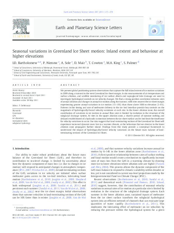
Fig. 1. a. Location of the study region on the western margin of the GrIS. The GPS sites are located along a transect across an altitudinal range of 450–1700 m.a.s.l. Simultaneous
measurements of air temperature and seasonal measurements of ablation were made at each site. The ELA in this region is at 1500 m (Van de Wal et al., 2005). Contours are produced
from a digital elevation model derived from InSAR (Palmer et al., 2011) at 100 m intervals. Lakes which drain in the interval between sequential MODIS satellite images during the
survey period are denoted by coloured patches which represent their surface area immediately prior to drainage (yellow: July 11th–15th; red: July 19th–23rd; blue: July 26th–29th).
The region in which lake drainage events were monitored is enclosed by the grey box and the catchment of the river which drains through Leverett glacier and which was also
monitored in 2009 is shown in red (Bartholomew et al., 2011). b. Ice surface (Krabill, 2010) and bed elevation (Bamber et al., 2001) profiles along the transect (black line, main
figure). The locations of the GPS sites are shown by black vertical marks.
cover the whole seasonal melt cycle. Measurements of air temperature were made using shielded Campbell Scientific T107 temperature
sensors connected to Campbell Scientific CR800 data loggers (sites 1, 3
and 6) and shielded HOBO U21-004 temperature sensors (sites 2, 4, 5
and 7) at 15 minute intervals throughout the survey period. Seasonal
melt totals were also measured using ablation stakes at each GPS site.
2.3. Proglacial discharge
We made continuous measurements of water stage in the proglacial
stream that emerges from the terminus of Leverett Glacier. Proglacial
discharge was derived from a continuous stage–discharge rating curve
calibrated with repeated dye dilution gauging experiments throughout
the melt-season as described in detail in Bartholomew et al. (2011).
2.4. Supraglacial lake evolution
We used satellite observations from the Moderate-resolution
Imaging Spectrometer (MODIS) to study the development of
supraglacial lakes within the region of our GPS transect (Fig. 1;
delimited by the grey line). 20 MODIS images, spanning the period
31st May to 18th August 2009, were used, representing all the days
when lake identification was not impeded by cloud cover. MODIS
level 1B Calibrated Radiances (MOD02) were processed and projected
as 250 m resolution true colour images in conjunction with the MODIS
Geolocation product (MOD03), according to the methodology laid out
by Gumley et al. (2003); see also Box and Ski (2007), and Sundal et al.
(2009). Lakes were digitised manually in order to allow classification
even on days of partial or thin cloud cover, producing a dataset with
slightly higher temporal resolution than fully automated classification
(Sundal et al., 2009). Drainage events were identified as occasions on
which the area of a lake decreased to zero (or a very small fraction of
its former size) without an intermediate period of refilling. Previous
studies have found that MODIS classification of GrIS supraglacial lakes
is robust when compared with higher resolution satellite data (Sundal
et al., 2009) and has approximate error of 0.22 km2 per lake. However,
since the lakes within this region are relatively small (typically
b1 km2) and there is considerable uncertainty in using a depthretrieval algorithm to determine the depth of individual lakes (Box
and Ski, 2007) we do not estimate individual lake volume. We note,
however, that on the basis of a recent theoretical study of supraglacial
lake drainage in the western GrIS (Krawczynski et al., 2009), any lake
which is large enough to be resolved on MODIS images (theoretically
one 250 m × 250 m pixel (0.0625 km2)) will contain enough water to
drive a water-filled crack through 1 km of ice.
2.5. Ice sheet surface characteristics
We used the MYD10A1 1-day albedo product, part of the MODIS
Aqua snow cover daily L3 global 500 m gridded product (Hall et al.,
2009a,b), to map changes in the albedo of the ice sheet surface in this
region of the GrIS through the survey period. These data are used to
quantify the lowering of surface albedo associated with meltwater
generation and retreat of the seasonal snowline through the survey
period. This product provides albedo values for pixels identified as
cloud free and snow-covered on a 500 m grid derived from a snapshot
taken once per day (Stroeve et al., 2006). We used 70 days of data,
from April 22nd to September 20th, representing all the days on
which the image was not obscured by cloud cover. This time period
covers the whole melt season, from before the onset of melt at the ice
sheet margin in spring, to the period of refreezing and snowfall in the
autumn. In order to integrate the albedo characteristics across the
region surrounding the transect, mean albedo was calculated by 50 m
elevation bands in the study region using a surface digital elevation
model (Palmer et al., 2011). Albedo thresholds for snow (b0.45) and
bare ice (N0.66) surfaces were used to classify pixels on the basis of
�274
a. Site 1, 456 m a.s.l
∆v =16.73 %
Σ w.e. ablation = 3.41 m
b. Site 2, 617 m a.s.l
∆v =18.35 %
Σ w.e. ablation = 2.85 m
c. Site 3, 794 m a.s.l
∆v =14.85 %
Σ w.e. ablation = 2.27 m
d. Site 4, 1061 m a.s.l
∆v =7.59 %
Σ w.e. ablation = 1.66 m
e. Site 5, 1229 m a.s.l
∆v =5.05 %
Σ w.e. ablation = 1.3 m
f. Site 6, 1482 m a.s.l
∆v =2.53 %
Σ w.e. ablation = 0.31 m
g. Site 7, 1716 m a.s.l
∆v =0.2 %
Σ w.e. ablation = 0.17 m
h.
400
300
200
100
0
400
300
200
100
0
400
300
200
100
0
400
300
200
100
0
400
300
200
100
0
400
300
200
100
0
400
300
200
100
0
400
300
200
100
0
7 May
1
10
0.5
5
0
2
0
10
1
5
0
1
0
10
0.5
5
0
1
0
10
0.5
5
0
1
0
10
0.5
5
0
1
0
10
0.5
5
0
0.5
0
10
Elevation (m); PDD
I.D. Bartholomew et al. / Earth and Planetary Science Letters 307 (2011) 271–278
0.25 5
0
1 Jun
1 July
1 Aug
1 Sep
1 Oct
0
1 Nov
2009
Fig. 2. a–g. 24-h horizontal velocity (black stairs), surface height (grey line) and positive-degree days (grey bars) at sites 1–7 for the survey period. The surface height is shown
relative to an arbitrary datum, with a linear, surface-parallel, slope removed. Winter background velocity (black dashes) is determined by bulk movement of each GPS site over the
subsequent winter. Text to the left of each panel shows the elevation, percentage annual velocity change due to summer velocity variations compared with values if the ice moved at
winter rates all year and the total surface ablation in water equivalence at each site for the whole survey period. h. Discharge hydrograph (black; m3s− 1) from Leverett Glacier in
2009. The estimated catchment for this outflow channel (Bartholomew et al., 2011) is shown on Fig. 1 and contains GPS sites 1, 2 and 3. The blue shaded sections identify pulses of
meltwater which are associated with dramatic reorganisation and expansion of the subglacial drainage system within the catchment.
field observations along the nearby K-transect (Knap and Oerlemans,
1996). A resulting transitional band between the two zones is
assumed to comprise a mixture of snow, ice with surface water and
slush surfaces and broadly delimits the transient snowline (Knap and
Oerlemans, 1996).
3. Hydrological forcing of velocity variations
Sites 1–6 all experience velocity peaks that are over 100% higher than
their winter background values (Fig. 2a–f). These variations begin
nearest the margin on May 22nd, and propagate inland following the
onset of surface melting up to a distance of 80 km from the GrIS margin
in late July, at 1482 m elevation. Initial uplift of the ice sheet surface at
each of these sites is interpreted to signal the establishment of a local
hydraulic connection to the ice sheet bed (Anderson et al., 2004;
Bartholomew et al., 2010; Das et al., 2008; Iken et al., 1983; Zwally et al.,
2002). A high-velocity ‘spring-event’, accompanied by uplift of the ice
sheet surface, characterises the start of locally-forced velocity variations
at each of these sites in a manner similar to Alpine and High Arctic
glaciers (Bingham et al., 2008; Iken et al., 1983; Iken and Bindschadler,
1986; Mair et al., 2001). This behaviour is consistent with inputs of
meltwater to a subglacial hydrological system which is incapable of
accommodating them without a great increase in pressure (Hooke et al.,
1989; Iken et al., 1983; Iken and Bindschadler, 1986; Mair et al., 2001;
Röthlisberger and Lang, 1987).
Although a small component of the coincident vertical and
horizontal velocity changes is due to thickness changes resulting
from longitudinal strain-rate or stress-gradient coupling, the signals
we observe cannot be attributed to these effects alone. Based on
motion of adjacent sites and ice thickness data (Fig. 1b; (Bamber et al.,
2001; Krabill, 2010)), we calculate that the thickness changes
originating due to longitudinal coupling are approximately an order
of magnitude smaller than the elevation changes we have recorded.
They also typically operate in the opposite direction as acceleration of
downstream sites causes extension and thinning of ice upstream as
opposed to the uplift observed. Throughout the summer, further
speed-up events which are coincident with ice surface uplift confirm
the role of surface generated meltwater in forcing seasonal changes in
ice motion for this section of the GrIS. We also note that the evidence
for hydraulically-forced enhanced basal motion implies that basal
temperatures along this transect are at the pressure melting point.
Immediately prior to the spring events most sites also experience a
short period of increased velocity in the absence of uplift of the ice
surface, which we attribute to mechanical coupling to ice downglacier
that is already moving more quickly (Price et al., 2008). At site 7, which
is located at 1716 m elevation, 115 km from the margin, there is no
surface uplift or significant ice acceleration indicating that surface
generated meltwater did not penetrate to the bed this far inland
(Fig. 2g). Site 7 does display a small, but clear, change in horizontal
velocity (Fig. 3), however, which can likely be attributed to coupling to
ice downstream. Since the magnitude of these changes is insignificant in
terms of annual ice flux, site 7 delimits the inland extent of
hydrologically forced velocity variations in 2009 for this transect.
3.1. Behaviour in the lower ablation zone
At sites 1–3, which are low in the ablation zone and experience the
greatest acceleration, spring-events occur early in the melt-season,
�275
I.D. Bartholomew et al. / Earth and Planetary Science Letters 307 (2011) 271–278
0.1
0
7 May
1 Jun
1 July
1 Aug
1 Sep
1 Oct
2009
Fig. 3. Detrended along-flow position for the GPS at site 7. The residual value indicates
the observed distance in metres of the GPS from the expected position if it flowed at its
mean rate for the whole survey period. Negative slopes therefore occur when the
velocity is slower than the survey period average and vice versa.
near the beginning of June, and ice velocity becomes less sensitive
to air temperature variations as the melt season progresses (Fig. 2).
This behaviour is explained by evolution in the structure of the subglacial drainage system in response to sustained inputs of meltwater
from the ice sheet surface, consistent with previous observations
and predictions of dynamic behaviour in this section of the GrIS
(Bartholomew et al., 2010; Pimentel and Flowers, 2010).
A recent hydrological study (Bartholomew et al., 2011) supports the
conclusion that evolution in the structure of the subglacial drainage
system is responsible for limiting the magnitude of hydrologicallyforced velocity variations at sites 1–3 later in the melt season.
Observations of hydrological parameters from a catchment that drains
through Leverett Glacier show that an efficient subglacial drainage
system expands upglacier at the expense of an inefficient one as the
summer progresses, a process that has been observed previously on
Alpine glaciers (Nienow et al., 1998). Episodic increases in the runoff
hydrograph (Fig. 2h), which are interpreted as evidence for dramatic reorganisation and expansion of the subglacial drainage system in
response to new inputs of meltwater from the ice sheet surface, have
a clear short-lived effect on the velocity records at sites 1, 2 and 3
(Fig. 2a–c,h). These events indicate, firstly, that sites 1–3 are within the
hydrological catchment of the river and, secondly, that changes in the
subglacial drainage system have a direct impact on ice velocity
downglacier from where they initially occur. The large volumes of
water exceed the capacity of the subglacial drainage system, causing
pressurisation, and a concomitant reduction in basal drag (Iken and
Bindschadler, 1986), as the water is transported to the ice sheet margin.
Clear daily-cycles in horizontal velocity occur at sites 2 and 3
following the spring events, and persist until mid-August. The
magnitude of these cycles is typically between 100 and 150% of the
mean daily velocity, and can be over 200% of winter background during
periods of significantly enhanced motion (Fig. 4). Their existence
indicates that over-pressurisation of the subglacial drainage system
also happens regularly on diurnal timescales. The daily cycles in ice
velocity appear to be closely related to variations in air temperature,
with a typical lag between peak temperature and peak velocity of less
than 3 h, suggesting that they occur in direct response to diurnal
variations in meltwater production at the ice sheet surface and that
surface and englacial transit times are short (Shepherd et al., 2009).
In addition to these short-lived events, ice velocities at sites 1, 2
and 3 are higher on the rising limb of the seasonal runoff hydrograph
for Leverett Glacier, subdued following peak discharge on July 21st,
and display a return to winter background rates in late August, when
runoff is diminishing (Fig. 2a–c,h). ‘Slower than winter’ ice velocities
are also observed for a short period at some sites once the summer
melt has stopped, however this signal is not large enough to have a
significant impact on rates of annual ice motion.
These findings from the lower ablation zone can be explained in
physical terms. Although increased efficiency of the subglacial hydrological system reduces the dynamic response to absolute water input
volume (Bartholomew et al., 2010), lake drainage and other singular
high velocity events, as well as diurnal fluctuations in horizontal velocity
testify that the system can still be overfilled by a large enough increase
in meltwater input, causing an increase in subglacial water pressure
(Das et al., 2008; Pimentel and Flowers, 2010; Schoof, 2010; Shepherd
et al., 2009). Production of surface meltwater, and its delivery to the ice–
bed interface, is inherently variable on timescales of hours, days, weeks
and months. Since the capacity of the subglacial hydrological system
reflects the balance between channel opening by melting of the channel
walls, and closure due to deformation of the surrounding ice, and adjusts
relatively slowly to changes in water flux (Röthlisberger, 1972; Schoof,
2010), the system never reaches steady-state. We argue, therefore, that
once a conduit has been established to deliver surface meltwater to the
glacier bed, large changes in the rate of meltwater delivery to the
subglacial hydrological system will continue to force velocity variations.
This analysis explains why high-velocity events at sites 1, 2 and 3
occur on the rising limb of the discharge hydrograph, when the system
is continuously challenged to evacuate larger and larger volumes of
water. Later in the season, when a channelised drainage system has been
established, and volumes of meltwater are diminishing, the drainage
system is better able to evacuate meltwater without overfilling,
explaining the reduction in magnitude of hydrologically-forced variations in ice motion. While ice velocities are subdued on the falling limb
of the runoff hydrograph, velocities at sites 1–3 still exceed winter flow
rates until mid-August. This appears to be the result of continued diurnal
fluctuations in ice velocity (Fig. 4), which occur until there is a dramatic
reduction in runoff volumes at Leverett glacier after August 15th
(Bartholomew et al., 2011).
3.2. Behaviour in the upper ablation zone
At sites 4–6, which are higher in the ablation zone (N1000 m), the
relationship between changes in the rate of horizontal motion and the
rate of uplift of the ice sheet surfaces indicates that the forcing
mechanism is the same as in the lower ablation zone. Mapping of
surface albedo using satellite data shows that the observed springevents at these sites follow the onset of surface melting above their
respective elevations (Fig. 5), although both satellite and in situ
observations showed that the snowpack was not fully removed at
sites 5 and 6 by the end of the summer.
a
300
Velocity (m yr−1)
position (m)
0.2
250
200
150
100
50
0
b
Temperature (oC)
0.3
6
4
2
0
−2
−4
25 July
1 Aug
8 Aug
13 Aug
Fig. 4. a. Daily cycles in horizontal ice velocities at sites 2 (blue) and 3 (magenta) for
∼3 weeks in late-July/early-August. 24-hour mean velocities are shown by black stairs
and coloured lines indicate winter background velocities. b. Temperature record for
sites 2 (blue) and 3 (magenta) for the same period.
�276
I.D. Bartholomew et al. / Earth and Planetary Science Letters 307 (2011) 271–278
Elevation (m)
1400
1200
1000
800
600
400
200
7 May
1 Jun
1 July
1 Aug
1 Sep
1 Oct
1 Nov
2009
Fig. 5. Ice sheet surface conditions inferred using the MODIS MYD10A1 1-day albedo
product. Thresholds for bare ice (b 0.45; black) and snow (N0.66; light grey) are used to
delimit zones across the study region by elevation (y-axis) throughout the survey
period (x-axis). A transitional zone (dark grey) is assumed to comprise a mixture of
snow, slush, surface water and bare ice surfaces and broadly delimits the altitudinal
extent of surface albedo changes caused by melting of the ice sheet surface (Knap and
Oerlemans, 1996). The timing and elevation of the onset of hydrologically forced
velocity variations, which occur at sites 1–6 successively, are denoted by crosses.
A key difference from the lower ablation zone is that the spring
events occur later in the melt season (Fig. 2a–g). There is also a
significant time lag between the onset of surface melting, as inferred
from both positive degree days (PDDs) and MODIS-derived albedo
values, and the establishment of a hydraulic connection between the
ice sheet surface and its bed as inferred from uplift of the ice surface.
This means that significant velocity enhancement occurs for a much
shorter time period than at lower elevations. At site 4, surface melting
begins in early June, while coincident surface uplift and horizontal
acceleration, which are diagnostic of local hydrological-forcing, are
delayed until July 5th (Fig. 2d). Increased velocities prior to this date,
which occur without accompanying surface uplift, are explained by
coupling to downglacier ice and are not as large as those induced by
local forcing at the sites nearer the margin. In situ measurements of air
temperature and satellite observations of surface albedo show that
sites 5 and 6 both experience prolonged surface melting from July 6th
onwards, and experience locally-forced velocity variations from July
12th and July 27th respectively (Fig. 2e,f). Later spring events and the
delay between the onset of surface melting and hydraulic connection
between the ice surface and its bed are due in part to lower rates of
surface melting. In addition greater volumes of water are required to
propagate fractures through thicker ice (Alley et al., 2005; Van der
Veen, 2007). These factors both increase the time required for the
accumulation of sufficient volumes of meltwater to penetrate to the
ice sheet bed.
Sites 4, 5 and 6 all experienced their highest velocities during a
period of cooler temperatures from July 22nd to August 2nd (Fig. 2d–f),
suggesting that drainage of stored surface water was a key factor in
these hydrologically-forced events. Satellite images show surface
meltwater accumulation in supraglacial lakes in this region from midJune at elevations between 1000 and 1200 m, and from 1200 m to
N1600 m from early July. This storage of surface meltwater is made
possible by relatively low surface gradients, which reduce the tendency
for water to runoff to lower elevations (Nienow and Hubbard, 2006),
and allows concentration of the large volumes of water required to
propagate fractures to the ice sheet bed through thick ice (Box and Ski,
2007; Das et al., 2008; McMillan et al., 2007; Sundal et al., 2009).
Using MODIS imagery, we identify a number of events where
changes in horizontal and vertical movement at one or more of our
GPS sites are coincident with the disappearance of supraglacial lakes
from the ice sheet surface. In particular, the spring event at site 5 on
July 12th is coincident with disappearance of three supraglacial lakes
from between 1200 and 1350 m elevation (Fig. 1, yellow). Widespread drainage of supraglacial lakes at elevations up to 1500 m
between July 19th and 23rd (Fig. 1, red) corresponds with increases in
ice velocity at sites 4 and 5 of up to 100 m y− 1 on July 21st and 22nd
respectively. The peak in horizontal velocities at sites 4, 5 and 6 at the
end of July also coincides with drainage of a lake at ∼ 1400 m elevation
and a number of lakes above ∼1500 m between July 26th and July
29th (Fig. 1, blue). It is not possible to be certain, using optical
imagery, that all lakes which disappear from the ice sheet surface
drain directly into englacial conduits. For example, some lakes may
drain superficially either into other lakes or to join with water input
points that are already open further downglacier. However, the
repeated coincidence of lake disappearance from the ice sheet surface
with changes in ice velocities suggests strongly that a large number of
these lakes drain to the ice–bed interface locally. Uplift of the ice
surface indicates that this water is delivered to a subglacial drainage
system which is unable to evacuate it without a large increase in
water pressure, leading to the enhanced basal motion (Das et al.,
2008).
Drainage of supraglacial lakes therefore appears to be responsible
for the initiation of hydrologically forced velocity variations at both
sites 5 and 6. It is not clear that the spring event at site 4, on July 5th, is
caused directly by drainage of supraglacial lakes. This site is located
by a large moulin which becomes active each year (Catania and
Neumann, 2010), and it is likely that the spring event is associated
with the re-opening of this moulin. A common factor in the upper
ablation zone, however, is that by the time a hydraulic connection has
been established between the ice sheet surface and its bed, facilitating
hydrologically-forced velocity variations, air temperatures and proglacial runoff are already decreasing. Lake drainage events are
known to be rapid, delivering large enough volumes of water to
quickly transform the subglacial hydrological system into an efficient
channelised network (Das et al., 2008). Under these circumstances, it
is unlikely that the volumes of water generated at the ice sheet surface
at these elevations following lake drainage events will be sufficient to
sustain large velocity variations (Pimentel and Flowers, 2010).
Accordingly, even though the temperature data show that considerable melting occurs at sites 4 and 5 until mid-August, we do not
observe any changes in ice velocity at sites above 1000 m elevation
beyond August 2nd.
3.3. Changes in annual motion
Annual mean ice velocities at sites 1–7 respectively are 16.7%,
18.4%, 14.8%, 7.6%, 5.1%, 2.5% and 0.2% greater than they would be if
the ice flowed at winter rates all year round. We find a strong
correlation between the magnitude of local ablation and the
percentage changes in annual ice motion due to hydrologically-forced
20
Percentage velocity change
1600
15
r2=0.92
10
5
0
0
0.5
1
1.5
2
2.5
3
3.5
Annual ablation (metres w.e.)
Fig. 6. Percentage change in mean annual ice velocity vs. total surface ablation (m w.e.)
at the GPS sites. The increase in annual ice velocity is calculated as the percentage by
which the observed annual displacement exceeds that which would occur if the ice
moved at winter rates all year round.
�I.D. Bartholomew et al. / Earth and Planetary Science Letters 307 (2011) 271–278
velocity variations at each GPS site (Fig. 6). Sites 1, 2 and 3, which are
nearest the margin and below 800 m elevation, experience the most
surface melting and show significantly greater annual acceleration
than those at higher elevations, with the effect attenuating inland.
Data from 2008 also show increases in mean annual ice velocity of
13.5% and 5.6% at sites 3 and 4 respectively due to summer velocity
variations (Bartholomew et al., 2010), indicating that the velocity
changes that we observe in 2009 are a persistent feature of the
dynamic behaviour of this part of the GrIS.
The relationship between rates of annual ablation and the
amplitude of hydrologically-forced velocity change is not intuitive
on the basis of previous theoretical work (Pimentel and Flowers,
2010) and observations (Van de Wal et al., 2008), which have
suggested that higher volumes of surface meltwater production will
ultimately reduce the impact of hydrological forcing on GrIS motion.
Implicit in these arguments is a concept of ‘optimum melt’: too much
meltwater and the hydrological system will become channelised
earlier in the summer, making ice velocities less sensitive to the
volumes of meltwater reaching the bed more quickly, reducing the
impact of seasonal velocity variations on the annual displacement
of the ice. However, it is important to consider that the hydrological
forcing at each site is a product of both local melting and meltwater
delivered through the subglacial drainage system from further
upglacier. As a result, sites nearest the margin will receive disproportionately more meltwater per unit of local melting than those at
higher elevations. Following this logic, previous theoretical work
(Pimentel and Flowers, 2010) and observations (Van de Wal et al.,
2008) expect sites nearest the margin, where the total flux of
meltwater through the subglacial drainage system will be greatest, to
show smaller overall velocity changes than sites further inland.
However, despite significant differences in the local volume of
meltwater delivered to the ice–bed interface, we see similar increases
in annual ice motion at sites 1–3 (14.8–18.4%).
Our findings from the lower ablation zone are consistent with the
numerical model of subglacial drainage proposed recently by Schoof
(2010) and suggest that hydrologically-forced ice velocity variations
are controlled more strongly by variations in the rate, rather than the
absolute volume, of meltwater production and delivery to the ice–bed
interface. In particular, this reflects a temporary imbalance between
the volume of water within the subglacial drainage system, and its
inability to evacuate this water without an increase in pressure over a
wide enough area to significantly affect basal motion (Kamb et al.,
1994). We argue that in a warmer climate, where greater volumes
of surface meltwater are produced in the lower ablation zone, the
seasonal rising limb and shorter-term variations in water delivery
to the subglacial drainage system will continue to cause significant
increases in annual ice motion despite the potential for an earlier
‘switch’ from a distributed to a channelised subglacial drainage
system (Schoof, 2010). However, the overall magnitude of velocity
variations will continue to be limited by evolution in the structure of
the subglacial drainage system, which responds to inputs of surface
meltwater over a longer period (Anderson et al., 2004; Bartholomew
et al., 2010; Mair et al., 2002; Schoof, 2010).
While development in the efficiency of the subglacial drainage
system also exerts some control on hydro-dynamic behaviour at
higher elevations, the dominant limiting factor on the contribution of
velocity variations to annual ice motion at sites in the upper ablation
zone is the shorter duration and later establishment of the hydraulic
connection between the ice sheet surface and its bed. The expectation
that surface melting will be more intense, and spatially extensive, in
a warmer climate (Hanna et al., 2008), leads us to suggest that, in
future, sites at higher elevations are likely to experience velocity
variations for a longer period of time, allowing a greater annual
change in ice velocity. In particular, higher rates of meltwater production would allow lakes that fill and subsequently drain to reach the
volume required to propagate cracks through thick, cold ice earlier in
277
the summer season (Krawczynski et al., 2009). We therefore expect
that the behaviour observed at sites 1–3 would be extended to higher
elevations, creating a positive relationship between atmospheric
warming and dynamic mass loss in land-terminating sections of the
GrIS, albeit one that is modified by development in the structure of the
subglacial drainage system.
We do not infer direct cause and effect between bulk volumes of
surface ablation and changes in ice motion on the basis of the
relationship shown in Fig. 6. Instead, our data show contrasting
regimes in hydrologically-forced dynamic behaviour of the GrIS at
different elevations within the ablation zone, which provide a
compelling explanation for the relationship between total surface
ablation and changes in annual ice motion. We therefore believe that
our data provide a realistic basis for parameterisation of ice flow
models that are used to predict the future evolution of the GrIS
(Parizek and Alley, 2004).
4. Conclusions
Our data show that seasonal changes in horizontal ice velocity
along an ∼115 km transect in a land-terminating section of the
western GrIS, are forced by the generation of surface meltwater which
is able to reach the ice–bed interface. These velocity variations
propagate inland from the ice sheet margin to progressively higher
elevations in response to the onset of surface melting, and the creation
of a hydraulic connection between the ice sheet surface and its bed.
We find a positive relationship between rates of annual ablation and
percentage changes in annual ice motion along the transect, with sites
nearest the ice sheet margin experiencing greater annual variations in
ice motion (15–18%) than those above 1000 m elevation (3–8%).
Patterns in the timing and rate of meltwater delivery to the ice–
bed interface are key controls on the magnitude of hydrologicallyforced velocity variations at each site. In the lower ablation zone
(b800 m elevation), ‘spring events’ occur early in the melt season and
the overall contribution of variations in ice motion to annual flow
rates is limited by evolution in the structure of the subglacial drainage
system (Bartholomew et al., 2010). At these sites, hydrologicallyforced ice acceleration is greatest on the rising limb of the seasonal
runoff hydrograph, when the hydraulic capacity of the subglacial
drainage systems is consistently exceeded. However, we find that this
behaviour is not replicated at sites in the upper ablation zone
(N1000 m), where the period of summer melting is shorter, and the
establishment of a hydraulic connection between the ice sheet surface
and its bed is delayed, limiting the timeframe for velocity variations to
occur.
In a warmer climate we expect seasonal melting of the GrIS surface
to extend over a wider area, and to be more prolonged (Hanna et al.,
2008). This makes it likely that volumes of meltwater sufficient to
reach the ice–bed interface will accumulate further from the ice sheet
margin and that the timing of meltwater input will occur earlier each
summer (Krawczynski et al., 2009; Sundal et al., 2009). Our data
therefore support the hypothesis that inland propagation of hydrologically-forced velocity variations will induce greater dynamic mass
loss in land-terminating sections of the GrIS in a warmer climate, as
patterns of hydro-dynamic behaviour observed in the lower ablation
zone extend upglacier. These considerations provide a conceptual
framework to understand the positive relationship between annual
rates of surface ablation and percentage variations in annual ice
velocity, and can be used to improve numerical simulations used for
predicting the impact of hydrologically-forced variations in ice
velocity on the future mass balance of the GrIS (Parizek, 2010).
Acknowledgements
We thank for financial support: UK Natural Environment Research
Council (NERC, through a studentship to IB and grants to PN and DM),
�278
I.D. Bartholomew et al. / Earth and Planetary Science Letters 307 (2011) 271–278
Edinburgh University Moss Centenary Scholarship (IB). GPS equipment and training were provided by the NERC Geophysical Equipment
Facility. MAK was funded by a RCUK Academic Fellowship. ERS SAR
data, for the surface DEM, were provided by the European Space
Agency VECTRA project (SP).
References
Alley, R., Dupont, T., Parizek, B., Anandakrishnan, S., 2005. Access of surface meltwater
to beds of sub-freezing glaciers: preliminary insights. J. Glaciol. 40 (1), 8–14.
Anderson, R., Anderson, S., MacGregor, K., Waddington, E., O'Neel, S., Riihimaki, C., Loso,
M., 2004. Strong feedbacks between hydrology and sliding of a small alpine glacier.
J. Geophys. Res. 109.
Bamber, J., Layberry, R., Gogineni, S., 2001. A new ice thickness and bed data set for the
Greenland ice sheet: I. measurement, data reduction, and errors. J. Geophys. Res.Atmos. 106, 33.
Bartholomew, I., Nienow, P., Mair, D., Hubbard, A., King, M., Sole, A., 2010. Seasonal
evolution of subglacial drainage and acceleration in a Greenland outlet glacier. Nat.
Geosci. 3, 408–411.
Bartholomew, I., Nienow, P., Sole, A., Mair, D., Cowton, T., Palmer, S., Wadham, J., 2011.
Supraglacial forcing of subglacial drainage in the ablation zone of the Greenland ice
sheet. Geophys. Res. Lett 38. doi:10.1029/2011GL047063.
Bingham, R., Hubbard, A., Nienow, P., Sharp, M., 2008. An investigation into the mechanisms
controlling seasonal speedup events at a High Arctic glacier. J. Geophys. Res. 113 (F2),
F02006.
Box, J., Ski, K., 2007. Remote sounding of Greenland supraglacial melt lakes:
implications for subglacial hydraulics. J. Glaciol. 53 (181), 257–265.
Catania, G.A., Neumann, T.A., 2010. Persistent englacial features in the Greenland Ice
Sheet. Geophys. Res. Lett. 37 (2), L02501.
Chen, G., 1999. GPS kinematic positioning for the airborne laser altimetry at Long
Valley, California. Ph.D. thesis, Massachusetts Institute of Technology.
Das, S., Joughin, I., Behn, M., Howat, I., King, M., Lizarralde, D., Bhatia, M., 2008. Fracture
propagation to the base of the Greenland Ice Sheet during supraglacial lake
drainage. Science 320 (5877), 778.
Gumley, L., Descloitres, J., Schmaltz, J., 2003. Creating Reprojected True Color Modis
Images: a tutorial. University of Wisconsin, Madison.
Hall, D., Nghiem, S., Schaaf, C., DiGirolamo, N., Neumann, G., 2009a. Evaluation of
surface and near-surface melt characteristics on the Greenland Ice Sheet using
Modis and Quikscat data. J. Geophys. Res. 114, F04006.
Hall, D.K., Riggs, G., Salomonson, V., 2009b. MODIS/Aqua Snow Cover Daily L3 Global
500m Grid, V005. National Snow and Ice Data Center, Boulder, CO, USA. May to
August.
Hanna, E., Huybrechts, P., Steffen, K., Cappelen, J., Huff, R., Shuman, C., Irvine-Fynn, T.,
Wise, S., Griffiths, M., 2008. Increased runoff from melt from the Greenland Ice
Sheet: a response to global warming. J. Climate 21 (2), 331–341.
Hooke, R., Calla, P., Holmlund, P., Nilsson, M., Stroeven, A., 1989. A 3 year record of seasonal
variations in surface velocity, Storglaciaren, Sweden. J. Glaciol. 35 (120), 235–247.
Iken, A., Bindschadler, R., 1986. Combined measurements of subglacial water pressure
and surface velocity of Findelengletscher, Switzerland: conclusions about drainage
system and sliding mechanism. J. Glaciol. 32, 110.
Iken, A., Rothlisberger, H., Flotron, A., Haeberli, W., 1983. The uplift of Unteraargletscher
at the beginning of the melt season, a consequence of water storage at the bed?
J. Glaciol. 29 (101), 28–47.
IPCC, 2007. Climate Change 2007: the Physical Science Basis: Contribution of Working
Group I to the Fourth Assessment Report of the Intergovernmental Panel on
Climate Change. Cambridge Univ Press.
Joughin, I., Das, S.B., King, M.A., Smith, B.E., Howat, I.M., Moon, T., 2008. Seasonal
speedup along the western flank of the Greenland Ice Sheet. Science 320 (5877),
781–783.
Kamb, B., 1987. Glacier surge mechanism based on linked cavity configuration of the
basal water conduit system. J. Geophys. Res. 92 (B9), 9083–9100.
Kamb, B., Engelhardt, H., Fahnestock, M., Humphrey, N., Meier, M., Stone, D., 1994.
Mechanical and hydrologic basis for the rapid motion of a large tidewater glacier 2.
Interpretation. J. Geophys. Res. 99 (B8), 15231.
King, M., 2004. Rigorous GPS data-processing strategies for glaciological applications.
J. Glaciol. 50 (171), 601–607.
King, R., Bock, Y., 2006. Documentation for the GAMIT GPS Analysis Software, Version
10.3. Mass. Inst. of Technol., Cambridge.
Knap, W., Oerlemans, J., 1996. The surface albedo of the Greenland ice sheet: satellitederived and in situ measurements in the Sondre Stromfjord area during the 1991
melt season. J. Glaciol. 42 (141), 364–674.
Krabill, W., 2010. IceBridge ATM L2 Icessn Elevation, Slope, and Roughness, [8.5.2010].
National Snow and Ice Data Center Digital Media, Boulder, Colorado USA.
Krawczynski, M., Behn, M., Das, S., Joughin, I., 2009. Constraints on the lake volume
required for hydro-fracture through ice sheets. Geophys. Res. Lett. 36 (10), L10501.
Mair, D., Nienow, P., Willis, I., Sharp, M., 2001. Spatial patterns of glacier motion during
a high-velocity event: Haut Glacier d'Arolla, Switzerland. J. Glaciol. 47 (156), 9–20.
Mair, D., Sharp, M., Willis, I., 2002. Evidence for basal cavity opening from analysis of
surface uplift during a high-velocity event: Haut Glacier d'Arolla, Switzerland.
J. Glaciol. 48 (161), 208–216.
McMillan, M., Nienow, P., Shepherd, A., Benham, T., Sole, A., 2007. Seasonal evolution of
supra-glacial lakes on the Greenland Ice Sheet. Earth Planet. Sci. Lett. 262.
Nienow, P., Hubbard, B., 2006. Surface and englacial drainage of glaciers and ice sheets.
Encyclopedia of Hydrological Sciences. John Wiley & Sons.
Nienow, P., Sharp, M., Willis, I., 1998. Seasonal changes in the morphology of the
subglacial drainage system, Haut Glacier d'Arolla, Switzerland. Earth Surf. Proc.
Land. 23 (9), 825–843.
Palmer, S., Shepherd, A., Nienow, P., Joughin, I., 2011. Seasonal speedup of the Greenland
Ice Sheet linked to routing of surface water. Earth Planet. Sci. Lett. 302, 423–428.
Parizek, B., 2010. Glaciology: sliding to sea. Nat. Geosci. 3 (6), 385–386.
Parizek, B., Alley, R., 2004. Implications of increased Greenland surface melt under
global-warming scenarios: ice-sheet simulations. Quaternary Sci. Rev. 23 (9–10),
1013–1027.
Phillips, T., Rajaram, H., Steffen, K., 2010. Cryo-hydrologic warming: a potential
mechanism for rapid thermal response of ice sheets. Geophys. Res. Lett. 37 (20),
L20503.
Pimentel, S., Flowers, G., 2010. A numerical study of hydrologically driven glacier
dynamics and subglacial flooding. Proc. R. Soc. A Math. Phys. Eng. Sci. doi:10.1098/
rspa.2010.0211.
Price, S., Payne, A., Catania, G., Neumann, T., 2008. Seasonal acceleration of inland ice via
longitudinal coupling to marginal ice. J. Glaciol. 54 (185), 213–219.
Pritchard, H., Arthern, R., Vaughan, D., Edwards, L., 2009. Extensive dynamic thinning
on the margins of the Greenland and Antarctic ice sheets. Nature 461 (7266),
971–975.
Röthlisberger, H., 1972. Water pressure in intra- and subglacial channels. J. Glaciol.
11 (62), 177–203.
Röthlisberger, H., Lang, H., 1987. Glacial hydrology. Glacio-Fluvial Sediment Transfer:
an Alpine Perspective, pp. 207–274.
Schoof, C., 2010. Ice-sheet acceleration driven by melt supply variability. Nature 468
(7325), 803–806.
Shepherd, A., Hubbard, A., Nienow, P., King, M., McMillan, M., Joughin, I., 2009.
Greenland Ice Sheet motion coupled with daily melting in late summer. Geophys.
Res. Lett. 36 (1), L01501.
Stroeve, J., Box, J., Haran, T., 2006. Evaluation of the MODIS (MOD10A1) daily snow
albedo product over the Greenland Ice Sheet. Remote Sens. Environ. 105 (2),
155–171.
Sundal, A., Shepherd, A., Nienow, P., Hanna, E., Palmer, S., Huybrechts, P., 2009.
Evolution of supra-glacial lakes across the Greenland Ice Sheet. Remote Sens.
Environ. 113, 2164–2171.
Sundal, A., Shepherd, A., Nienow, P., Hanna, E., Palmer, S., Huybrechts, P., 2011. Meltinduced speed-up of Greenland Ice Sheet offset by efficient subglacial drainage.
Nature 469 (7331), 521–524.
Truffer, M., Harrison, W., March, R., 2005. Record negative glacier balances and low
velocities during the 2004 heatwave in Alaska, USA: implications for the
interpretation of observations by Zwally and others in Greenland. J. Glaciol.
51 (175), 663.
Van de Wal, R., Greuell, W., van den Broeke, M., Reijmer, C., Oerlemans, J., 2005. Surface
mass-balance observations and automatic weather station data along a transect
near Kangerlussuaq, West Greenland. Ann. Glaciol. 42, 311–316.
Van de Wal, R., Boot, W., Van den Broeke, M., Smeets, C., Reijmer, C., Donker, J.,
Oerlemans, J., 2008. Large and rapid melt-induced velocity changes in the ablation
zone of the Greenland Ice Sheet. Science 321 (5885), 111.
Van der Veen, C., 2007. Fracture propagation as means of rapidly transferring surface
meltwater to the base of glaciers. Geophys. Res. Lett. 34 (1), L01501.
Zwally, H., Abdalati, W., Herring, T., Larson, K., Saba, J., Steffen, K., 2002. Surface meltinduced acceleration of Greenland ice-sheet flow. Science 297 (5579), 218.
�
 T. Cowton