Academia.edu no longer supports Internet Explorer.
To browse Academia.edu and the wider internet faster and more securely, please take a few seconds to upgrade your browser.
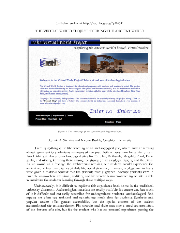
The Virtual World Project: Touring The Ancient World
 Ronald Simkins
 Nicolae Roddy
Related Papers
Near Eastern Archaeology
Immersing in Mesopotamia: Virtual Reality Site Tours in the Remote Classroom2023 •
** Open Access ** Virtual Reality (VR) holds the potential to improve student spatial and visual learning in archaeology through embodied 3D interaction with ancient spaces and objects. For an introductory course on Mesopotamian archaeology that spanned the Uruk to Achaemenid periods, we experimented with VR tours as part of the student learning experience. Although there are many publications covering the use of VR for cultural heritage/public history or for teaching in other fields, examples from the archaeological classroom are limited. To get a sense of what is possible for archaeological learning today, we undertook a rapid pilot experiment to prepare ourselves for future, more structured, educational research. This pilot helped us to explore the logistical concerns of deploying VR in an undergraduate course. We also interviewed the students several months after the course to hear about their experiences with VR learning. We share our experiences here to encourage other experiments with VR teaching in the archaeological classroom.
García-Peñalvo, F.J., García-Holgado, A. (eds) Proceedings TEEM 2022: Tenth International Conference on Technological Ecosystems for Enhancing Multiculturality. TEEM 2022. Lecture Notes in Educational Technology. Springer, Singapore
A Proposal for Innovative Higher Education in Archaeology Through the Use of Virtual Tours.2023 •
The research presents an interactive, stimulating and enriching methodology for the students of the Archaeology Degree, using Information and Communication Technologies (ICT) and the application of virtual environments in the teaching-learning process. Beyond the clear benefits of virtual tours in the interpretation, dissemination and knowledge of historical sites and their surroundings, they can also mean a really useful tool in the teaching practice. In this way, the present proposal is designed to verify how the access to multi-source and spatially geolocated information allows students to acquire basic knowledge and skills to understand multi-causal historical phenomena, which also have to be located in their geographical, historical and cultural/artistic context. This fact makes these virtual tools a unique opportunity for professors to introduce them into the teaching-learning process. This contribution is thus essential to help students to contextualize the theoretical knowledge and bring them closer to the real archaeological practice, allowing them to better understand the challenges they will face in their future professional life.
Although archaeology and history are today independent disciplines, any work in the archaeology of Levant will eventually have to address issues stemming from historical texts. This is true for all archaeology of cultures that produced texts, but especially true for the archaeology of Israel and Jordan because of the role that the Bible has played in the history of that archaeology. The archaeology of Israel and Jordan has often and traditionally been characterized as " biblical archaeology. " That is, its subject has been the archaeology of the people and the region of the Bible, and its purpose has been to correlate the archaeological data with the biblical record. Indeed, much of the earlier archaeological work done this century has had the purpose of bringing clarity or verification to a biblical story. On the positive side, this connection between the Bible and archeology is responsible in part for the popularity (and romance) of archaeology for the general public. Moreover, the results of biblical archaeology have indeed shed much light on the biblical literature. But on the negative side, biblical archaeology has had the tendency to blur the methodological limits and domains of the disciplines of archaeology and history (and biblical studies in particular). Students of the history and the Bible need to beware of a common naïve assumption regarding the relationship between history and archaeology: Archaeology serves to complement history and to support or falsify the historical record. This assumption is an expression of the commonly held priority that is given to literary texts. Literary evidence often sets the agenda for the research of non-literary material culture. The corollary to this assumption is that non-literary material culture is mute, cannot speak, without an appropriate context supplied by literary evidence. Unfortunately, this assumption expresses a naiveté about the role of material culture (symbolic expressions) for constructing meaning about the past. Indeed, it is because of the inherent deficiencies of historical texts for understanding the society, economy, and religion of an ancient people that archaeology provides such a valuable resource. But the material remains of archaeology are not subordinate to the textual record for historical study. Like texts themselves, material remains are symbolic expressions encoding messages about the past. They similarly require a critical interpretation before they can be used in understanding the past. Material remains are thus not mute; rather, the historian must learn to " hear " what they " speak " about the past in dialogue with the questions posed to them. For example, faunal remains " tell " about the economy of a people, about their vocations, about their diet; architectural structures " give witness " to the social and gender stratification of society and to the kinship structures and relations within a
Workshop in VIRTUAL ARCHAEOLOGY (nondestructive methods of prospections, modeling, reconstructions) Proceedings of the First International Conference held at the State Hermitage Museum 4–6 June 2012
Archaeological Computing Newsletter
The Sen-nedjem Project: Archaeology, Virtual Reality and Education1999 •
Virtual reality, interactive computer generated sites and scenarios, theoretically creates great opportunities for archaeology, history, and education. Immersive computer driven environments impart information regarding space and human experience that would not be possible using traditional means of representation. Places and structures too remote, dangerous or deteriorated to visit can be experienced, and virtual models can provide the context in which to understand other complex issues surrounding an environment. In the ...
Parts of this research project were presented at the Joukowsky Institute for Archaeology and the Ancient World at Brown University's Brown Bag Series, and it was also presented with co-author and presenter Jeffery Jacobsen at the XXXVIII Computer Applications and Quantitative Methods in Archaeology Conference in Granada, Spain (2010).
Studies in Digital Heritage
A Role for Immersive Visualization Experiences in Teaching Archaeology2019 •
As archaeologists continue to utilize digital 3D visualization technologies, instruction can also benefit from purpose-driven uses of these data. This paper outlines a pilot project that used previously captured 3D data in a large-scale immersive environment to supplement the instruction of basic archaeological concepts to an undergraduate introductory anthropology class. The flexibility of the platform allowed excavation trenches to be investigated in three-dimensions, enhancing the understanding of excavation methods and providing additional insight in the choices of the excavators. Additionally, virtual investigation of the artifacts provided a way for students to interact with objects on the other side of the world in a more complete way. Instructor-led immersive virtual experiences have significant potential to widen the interest in archaeology and enhance the instruction of archaeological concepts. They allow students to interact with the content, guided by an expert, and in the presence of each other. While the facilities are not available at every university at the current time, the cost effectiveness and ability to deliver these experiences via head-mounted displays represents an exciting potential extension for complementary self-paced, yet guided, exploration.
Proceedings Seventh International Conference on Virtual Systems and Multimedia
Teaching with immersive virtual archaeology2001 •
Journal of Archaeology and Education
Theoretical Foundations for Archaeological Pedagogy with Digital 3D, Virtual, Augmented, and Mixed Reality Technologies2024 •
** Open Access ** Archaeology is inherently a visual and spatial discipline and thus we should strive to center student learning within visual and spatial media. Apart from museum work, site visits, and fieldtrips, the traditional tools of the classroom, however, tend to only convey textual or two-dimensional abstractions of primary archaeological data. The latest digital 3D and eXtended Reality (XR) technologies (virtual, augmented, and mixed) hold the potential for engagement with information in ways that more closely represent the true three-dimensional and visual nature of archaeological objects, spaces, and landscapes. This should allow for an embodied mode of interaction that significantly improves understandings of space and visual content. To maximize these benefits, our deployment of these technologies in the classroom should be guided by formal educational theory and research as well as by prior experiments. Here, we introduce theoretical perspectives on visual and spatial learning, as well as other educational theories, relevant to teaching the humanities and the material past. Our goal is to provide a range of theoretical foundations for pedagogical experiments that involve deploying XR teaching in the archaeological classroom.
2022 •
RELATED PAPERS
HUFFINGTON POST, December 24
Πριν 200 χρόνια: Ο περιπετειώδης κατάπλους του Λόρδου Βύρωνα στο εμπόλεμο Μεσολόγγι ανήμερα Χριστουγέννων 1823.2023 •
in E. Kaiser, M. Meyer, S. Scharl, S. Suhrbier (eds.), Wissensschichten - Festschrift für Wolfram Schier zu seinem 65. Geburtstag. Internationale Archäologie Studia Honoraria Band 41
Spheres of interaction in the Adriatic Bronze Age (19th−12th centuries BC)2022 •
2017 IEEE International Conference on Pervasive Computing and Communications Workshops (PerCom Workshops)
Inertial Navigation algorithms2017 •
Journal of Oleo Science
Development of EMS-induced Mutagenized Groundnut Population and Discovery of Point Mutations in the ahFAD2 and Ara h 1 Genes by TILLING2021 •
International Journal of Applied Research
Scapula dyskinesia in hospital housekeepers: A prevalence study2021 •
The Pharma Innovation Journal
Effect of spacing and thinning on growth and flowering of Alstroemeria hybrida L2021 •
ITE Transactions on Media Technology and Applications
[Invited Paper] HDR Tone mapping: System Implementations and BenchmarkingAmerican Scientific Research Journal for Engineering, Technology, and Sciences
Household Water Conditions in Gombe: A Profile of Water Scarcity in Nassarawo, Palliative and Mitigation Measures2018 •
Solid State Communications
Observation of gap-energy radiation from superconducting tin and indium1981 •