Academia.edu no longer supports Internet Explorer.
To browse Academia.edu and the wider internet faster and more securely, please take a few seconds to upgrade your browser.
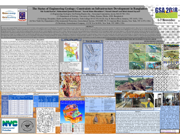
The Status of Engineering Geology: Constraints on Infrastructure Development in Bangladesh
The Status of Engineering Geology: Constraints on Infrastructure Development in Bangladesh
 Mir F Karim
 Muhammad-Qumrul Hassan
2018, GSA Annual Meeting in Indianapolis, Indiana, USA - 2018 Paper No. 30-17
In recent years, megacity Dhaka is known to have one of the fastest urban population growths in Bangladesh. The population in Dhaka and other megacities has increased from 7 to 50 million during the last four decades. The rapid rate of urban population growth, along with the extreme paucity of real-estate for new infrastructure development or upgrading existing facilities, is already exacerbating the situation for the city planners and exerting tremendous pressure to come-up with viable solutions. Although practice of engineering geology, geotechnical exploration, and testing exists in Bangladesh; the system has still yet to adopt controlled quality standards with unified and professionally acceptable methods. There is a dire need for accessing shallow borehole data via a central depository system in order to initiate, reassess and provide sound geoengineering recommendations for any contemplated capital construction projects. A well-coordinated system involving city agencies and private sectors can ease the situation for effecting communication regarding knowledge-sharing and keeping involved geotechnical personnel informed about already acquired data. Several development projects of the country received finance from various sources and were monitored by various agencies with prescribed methodology for execution and implementation. This diversity of funding, ownership and oversight of the projects has put the geotechnical exploration and testing system into challenging state in Bangladesh. Integration of pertinent geomorphic, regional geology, bedrock, water table and soil data will certainly aid understanding the constraints associated with any subsurface construction. Mega cities such as Dhaka and Chittagong will require intense modification in order to accommodate urban facilities, including installation of a multilevel transportation system with underground space utilization. On a positive note, the megacity of Dhaka has suitable natural ground conditions typified by sound geoengineering parameters. Standard geotechnical exploration coupled with assessment of geomorphic and geotechnical attributes will augment existing data to characterize geological materials and prepare detailed engineering/geotechnical reports to be used for design and capital construction projects. Geotechnical information from the recently completed City Water Tunnel # 3 (New York City) is considered.
Related Papers
Foreword A request was made to the Director General, Geological Survey of Bangladesh (GSB) by The Louis Berger Group, INC and Bangladesh Consulting Ltd. to provide a geological evaluation of Dhaka City for understanding of and planning of underground transportation system under Strategic Transportation Planning Project of the Government of Bangladesh. This evaluation report is prepared using geological investigation reports and technical papers available in the GSB. Emphasis is given to provide some concept on the sub-terrain environment and ground condition of Dhaka city. An interpretation on the engineering geological advantages and disadvantages for planning, designing and development of underground transportation system is done. Summary The City of Dhaka occupies a unique geological location in terms of the geological set up and ground condition. Geologically the city landmass is a part of an old terrace that is raised considerably up than the surrounding floodplains. The general elevation in the axial part of the city reaches up to about 6 to 7m above mean sea level (AMSL) whereas the surrounding floodplains are at about 4m AMSL. The ground of the terrace is composed of Madhupur Clay (Pleistocene), consisting of very stiff to hard, reddish brown, highly ferruginous, plastic Clay-Silt with some minor contents of fine quartz-sand and iron concretions. The shear strength properties are considerably high and the average value of un-drained shear strength is ≈ 2 kg/cm2. The settlement characteristics indicate that the red clay to be an over-consolidated stratum. The geological history indicates that due long run erosion about 20m of materials have been removed from the top of the city ground. This indicates that an amount of ≈ 1 kg/cm2 of vertical stress has removed from the top of the existing ground surface. At present the average thickness of Madhupur Clay in the main urban area is about 7 meters. The upper clay-silt stratum overlies a firm sand bed, geologically known as Dupitila Formation (Upper Tertiary). The geological and geotechnical properties of Dupitila Sand (Upper Dupitila Sandstone) tends to behave as soft rock. This soft sedimentary rock acts as dense bedrock to hold most of the pile tips of all deep foundation which is uniformly distributed throughout the axial part of the city. In terms of hydro-geological environment the Madhupur Clay Formation acts a wonderful cap over the Dhaka terrain. The top material is low in permeability and no ground water recharge occurs in the city area at ambient condition. The surface materials and natural topography with unique natural drainage system the flash-flood water has excellent run-off characteristics. The permanent and confined ground water level is located below 70m from the surface. The existing geo-hydrological environment provides better options for underground excavation. The existence of Madhupur Clay and Dupitila Sand below the urban feet turns the ground condition of Dhaka city to the best comparing the ground condition of many other cities of the world. Though Bangladesh is located at edge of most seismically active global zone, in terms of the ground condition the apparent seismic hazard* is relatively low in Dhaka city than most of other parts of the country (expected maximum Peak Ground Acceleration is 0.5g). A correlation on Shear Wave Velocity (Vs) of the geological materials underneath Dhaka city indicates that the value of Vs would be > 350 m/sec. Considering the geological and geotechnical aspects, the city of Dhaka has advantageous ground condition for construction of underground engineering structures including underground rapid transportation system. (*Caution: The low seismic hazard does not mean lower seismic risk, as the risk is directly related to human activity and response to seismic issues.)
Geologically, the Dhaka-Tongi area consists of parts of high inlier, along narrow tract of older sediments hosting the major parts of the city and surrounded by very young riverine sediments occupying the surrounding valleys. The drainage patterns of this tract consist of two types, dendritic and trellis. The older sediment sequence consists of sandstone of Dupi Tila Formation overlain by by the Madhupur Clay. The Clay is overlain by alluvium, but is locally exposed in stream valleys. The region can be divided into three types of landforms – a central high area, a complex of high and lowareas band a complex of low areas. The ground condition with respect to construction can be rated as: favourable, poor and hazardous. The techniques for ground improvement depend on the ground conditions which are intimately related to the geology (sediment type and structure) and geomorphology (landform and elevation). The type of site preparation techniques applicable during pre-construction development are variable from simple removal of the surficial soft soil followed by a sand fill and compaction to more complex techniques of using geotextile, grouting, preloading and surcharge. Taking account of above, a model is suggested which can be used to choose the appropriate ground improvement technique.
Atlas of Urban Geology, FORUM ON URBAN GEOLOGY IN ASIA AND THE PACIFIC, THE GROUND BENEATH OUR FEET: A FACTOR IN URBAN PLANNING, UN ESCAP
GEOLOGICAL ASPECTS OF URBAN PLANNING IN BANGLADESH1999 •
The rapid growth of population, urbanization, communication and infrastructure development in Bangladesh has sharpened the need of understanding the geological processes that some times cause severe natural and man-made disasters. The natural landscape of Bangladesh can distinctly be portrayed as active plains of fluvial, deltaic and coastal environments, having few strips of low hills in the east and northeast. The country is prone to annual flood and other climatic hazards. The general elevation of the deltaic and coastal plain land is only 2 to 4m above mean sea level. There are number of large and small clusters of urban growth throughout the country, among these the capital city of Dhaka, the port cities of Chittagong and Khulna (Mongla Port), Rajshahi, Sylhet, Mymensingh, Bogra and Barisal are important. Most of the urban centers are located on naturally raised land facets. The physical growth of these urban centers is so fast that it has become difficult to maintain a systematic land-use pattern of these clusters. The geological disadvantages or advantages for economic and rational engineering design are overlooked. For this many of the newly grown areas have incurred severe damages due to flood, cyclone and tidal surges, riverbank and coastal erosions, landslides, soil collapse and foundation failures. Due to increased frequency of failures in different projects and structures, the concerned authorities are paying attention to the inherent causes of the failure or taking measures to avoid further disruptions. After the independence of Bangladesh the development activities started so rapidly that a time lag remained between the planners and developers in interchanging the necessary geo-information and data for rational designing or formulation of the projects. In recent years, the city planners and other national organizations like the city improvement authority, the roads and high ways department and the public works department have extended hand for geological information for proper understanding of geological aspects of their projects. Considering these, the Geological Survey of Bangladesh (GSB) has taken up a National Mapping Programme for preparation of geological maps in the scale of 1: 50,000 and engineering geological maps in the scale of 1: 20,000 of different cities and town of the country. So far the GSB has completed about 35% of country's geological mapping and engineering geological mapping of seven cities and towns, among these the urban geological maps of Dhaka and Chittagong cities are most significant achievements. These maps are yet to be published. This paper describes the present status, prospects and types of geological or geo-environment data, maps and other information available to planners and developers. The means for optimum utilization of hard achieved geological and geotechnical data for rational utilization in the urban and infrastructure developments are proposed.
The Madhupur Clay soil of the studied area is composed predominantly of silt size particles with small amount sand and clay. Three stratigraphic units have been identified namely Unit A, Unit B and Unit C. The lowermost unit (unit A) is mainly a sandy non cohesive unit. This unit is light reddish yellow or pale reddish yellow in colour, dense to very dense in nature. Unit B is mainly a silty sand unit which is mottled, light reddish yellow or pale reddish yellow in colour and medium dense to dense. The topmost unit (unit C) is mainly a clay unit which is pale grayish to light reddish yellow in colour, mainly medium to stiff in nature and show medium plasticity. The SPT value of study area ranges from 4 to 60 and increases with increasing depth in all the bore holes. The layer of the cohesive clay soil (Unit C), extending to the depth of 0-28 feet, usually has the consistency that varies from medium to stiff. Further below, the non cohesive silty and sandy layers (Unit B & A respectively), extending to the depth of about 28-65 ft, usually have been found in a medium dense to very dense state. The sand percentages are increasing with increasing depth whereas the silt and clay percentages are decreasing with increasing depth. The obtained values of the Cu and Cg suggest that the studied samples are uniformly graded to well graded soil. The upper soil is suitable for light and moderate load bearing structures (up to 35 feet) whereas the lower soil is very much suitable for heavy structures (below 35 feet depth).
jollygreengiant.fullnetwork.org
URBAN GEOLOGY: A CASE STUDY OF KHULNA CITY CORPORATION, BANGLADESH2006 •
isara solutions
Unravelling the Peril and Impact of Fake News on SocietyIn an era characterised by the rapid dissemination of information through digital platforms, the proliferation of fake news has emerged as a pressing global concern. This research study investigates fake news's peril and far-reaching impact on contemporary society. The study is driven by the recognition that fake news, intentionally false or misleading information presented as factual news, poses a multifaceted threat to individuals, communities, and democratic processes. The study will employ a multidisciplinary approach, combining elements of communication studies, psychology, sociology, and data analysis to examine the mechanisms by which fake news is generated, disseminated, and consumed. Through qualitative and quantitative research methods, the research will explore the cognitive, emotional, and social consequences of exposure to fake news, shedding light on the erosion of trust, the amplification of polarisation, and the potential for real-world harm.
Tạp chí Y học Việt Nam
Thực Trạng Khẩu Phần Ăn Bán Trú Của Trẻ Em Hai Trường Mầm Non Tại Huyện Phú Lương, Tỉnh Thái Nguyên Năm 20212022 •
RELATED PAPERS
2009 •
2013 •
Indian Journal of Forensic Medicine & Toxicology
Purification and Characterization of Arginase from Serum of Healthy and Type II Diabetic Iraqi Patients2021 •
Journal of Biomedical Sciences
Therapeutic Effects of Albendazole on Kidney Functions and Urinary Excretion of Florfenicol in Goats2017 •
Opiniães – Revista dos Alunos de Literatura Brasileira
Estatuária do desejo: a escrita erótica e o jogo da imitação em "Lucíola"