Global and Planetary Change 71 (2010) 73–84
Contents lists available at ScienceDirect
Global and Planetary Change
j o u r n a l h o m e p a g e : w w w. e l s ev i e r. c o m / l o c a t e / g l o p l a c h a
Controlling weathering and erosion intensity on the southern slope of the Central
Himalaya by the Indian summer monsoon during the last glacial
Yoshihiro Kuwahara a,⁎, Yukiko Masudome a, Mukunda Raj Paudel a,1, Rie Fujii a,b, Tatsuya Hayashi a,c,
Mami Mampuku a, Harutaka Sakai a,b
a
Department of Environmental Changes, Faculty of Social and Cultural Studies, Kyushu University, Motooka, Fukuoka 819-0395, Japan
Department of Geology and Mineralogy, Division of Earth and Planetary Sciences, Graduate School of Science, Kyoto University, Kyoto 606-8502, Japan
National Museum of Nature and Science, Department of Geology and Paleontology, Division of Paleoenvironment and Paleoecology, Hyakunin-cho 3-23-1,
Shinjuku-ku, Tokyo 169-0073, Japan
b
c
a r t i c l e
i n f o
Article history:
Received 30 June 2009
Accepted 30 December 2009
Available online 11 January 2010
Keywords:
Indian monsoon
last glacial
paleoclimate
weathering
clay minerals
Nepal Himalaya
a b s t r a c t
This paper reports the results of clay mineral analysis (the amount of clay fraction, clay mineral assemblages,
illite crystallinity) of samples collected from a drilled core (Rabibhawan (RB) core) located in the westcentral part of the Kathmandu Basin on the southern slope of the Central Himalaya. The amount of clay
fraction in the core sediments between 12 m and 45 m depth (corresponding to ca. 17–76 ka), which belong
to the Kalimati Formation, is variable and shows three clay-poor zones (19–31 ka, 44–51 ka, and 66–75 ka).
The variations correspond with those of illite crystallinity index (Lanson index (LI) and modified Lanson
index (MLI)) and kaolinite/illite ratio as well as the fossil pollen and diatom records reported by previous
workers. These data reveal the following transformations occurring during the weathering process in this
area:
micas ðmainly muscoviteÞ→illiteð→illite−smectite mixed layer mineral ðR = 1ÞÞ→kaolinite
The sedimentation rate (~ 50 cm/kyr) of clay-poor zones that correspond to dry climate intervals is only half
that of clay-rich zones (~ 120 cm/kyr) that correspond to wet climate intervals, indicating weakened
chemical weathering and erosion and low suspended discharge during dry climate intervals. The clay-poor
zones commonly show unique laminite beds with very fine, authigenic calcite, which was probably
precipitated under calm and high calcite concentration conditions caused by low precipitation and run-off.
The variations between dry and wet conditions in this area as deduced from clay minerals appear to follow
the Indian Summer Monsoon Index (ISMI) (30°N–30°S, 1 July) and northern hemisphere summer insolation
(NHSI) signals (30°N) at 1 July, especially during the dry climate zones, whereas the wet maxima of the wet
climate zones somewhat deviate from the strongest NHSI. On the other hand, the dry–wet records lead
markedly the SPECMAP stack (by about 5000 years). These results suggest that the Indian summer monsoon
precipitation was strongly controlled by the NHSI or summer insolation difference between the Himalayan–
Tibetan Plateau and the subtropical Indian Ocean, showing a major fluctuation on the 23,000 years
precessional cycle, and that it was not driven by changes in high-latitude ice volume, although the records of
clay mineral indices during the wet intervals leave a question that other factors, in addition to insolation
forcing, may play important roles in weathering, erosion, and sedimentation processes.
© 2010 Elsevier B.V. All rights reserved.
1. Introduction
The Indian monsoon system is one of the major weather systems
on the Earth and affects most densely populated regions. Differential
heating during summer results in a seasonal low pressure cell over the
⁎ Corresponding author. Tel.:+81 92 802 5654; fax:+81 92 802 5662.
E-mail address: ykuwa@scs.kyushu-u.ac.jp (Y. Kuwahara).
1
Present address: Department of Geology, Tribhuvan University, Trichandra
Campus, Ghantaghar, Kathmandu, Nepal.
0921-8181/$ – see front matter © 2010 Elsevier B.V. All rights reserved.
doi:10.1016/j.gloplacha.2009.12.008
Indian continental landmass and a high pressure cell over the cooler
Indian Ocean. As a consequence, warm humid southwest summer
winds from the Indian Ocean flow onshore and contribute most to the
rainfall (Colin et al., 1998; Kudrass et al., 2001; Rashid et al., 2007).
Most of the monsoonal precipitation falls on the catchments of the
Ganges–Brahmaputra–Meghna (GBM) river system, whose rivers
drain most of the Himalayas and the northern Indian subcontinent
(Kudrass et al., 2001; France-Lanord et al., 2003; Rashid et al., 2007).
Water and suspended discharge of the river system, therefore, get
concentrated during only five months (June to October) of the
�74
Y. Kuwahara et al. / Global and Planetary Change 71 (2010) 73–84
summer monsoon (Islam et al., 2002; Goodbred, 2003). Natural
calamities, such as flooding or landslide, are also more frequent
during this season (Rashid et al, 2007).
It is naturally expected that past modifications of the intensity of
chemical and physical weathering and erosion of the Himalayan and
Burman ranges and the GBM catchments are strongly related to past
variations in the strength of the Indian summer monsoon (Colin et al.
1998). It is known that numerous paleoclimatic studies, based on
several proxies such as % Globigerina bulloides, organic carbon content,
lithogenic grain size, and pollen content, have permitted reconstruction of changes in the paleo-monsoon intensity (e.g., Anderson and
Prell, 1993; Sirocko et al., 1993; Overpeck et al., 1996; Schulz et al.,
1998; Ivanochko et al., 2005). These proxies, however, are generally of
monsoon wind strength and monsoon wind-induced upwelling,
rather than precipitation (Tiwari et al., 2006; Rashid et al., 2007;
Shakun et al., 2007). Rashid et al. (2007) state that summer
monsoonal precipitation on the Indian subcontinent is not linearly
correlated to wind strength, because it depends on the moisture
content of the incoming monsoon winds, which is determined by sea
surface temperature (SST) in the southern hemisphere and by the
convergence and rate of ascent of the air parcels after they cross the
Indian coast. On changes in the strength of the Indian summer
monsoon precipitation or in the intensity of weathering and erosion
induced by precipitation, continental records from the Himalayas and
the north Indian subcontinent, where Indian summer monsoon winds
blow directly, are extremely rare (Sinha et al., 2005), while the
records from marine sediments are many (e.g., Bay of Bengal and
Andaman Sea: Colin et al., 1998, 1999; Rashid et al., 2007, Arabian Sea:
Sirocko et al., 1991, 1993, 2000; Tiwari et al., 2006).
Precipitation plays a key role in the formation, weathering, erosion
and transport of clay minerals to the depositional basins (Singer,
1984; Chamley, 1989; Robert, 2004). Therefore, clay minerals can be
useful indicators of paleoclimatic conditions and have been used to
estimate the intensity of precipitation or continental wetness (Robert
and Kennett, 1994; Diester-Haass et al., 1998; Robert, 2004).
However, paleoclimatic interpretation of clay minerals or other
mineralogical indices such as grain size in sediments, especially of
those transported from large source areas such as the Himalayas and
the northern Indian subcontinent to the Indian Ocean, is anything but
straightforward. This is because weathering, erosion, transport and
sedimentation processes are controlled by many factors (e.g., mixing
of exotic minerals, selective erosion and transport, mixing of detrital
and authigenic clay minerals, asynchronous weathering and transport/deposition) (Singer, 1984; Chamley, 1989).
Moreover, Kübler Index (KI) (Kübler, 1964), which is conventional
illite crystallinity index defined by the full width at half maximum
intensity (FWHM) of 10 Å illite X-ray diffraction (XRD) peak and has
extensively been used to reconstruct the paleoclimate (e.g., Chamley
1989; Fukuzawa et al. 1997; Lamy et al. 2000), is not always available
for estimation of illite crystallinity (Srodon, 1979, Srodon and Eberl,
1984; Lanson, 1997; Kuwahara et al., 2001). According to Srodon
(1979), the KI is significantly larger for finer fractions because the
FWHM of the illite 001 peak is mostly a function of the amount and
composition of the illite–smectite mixed layer (I–S) component of the
sample and the I–S component has a finer particle size than illite. To
overcome this problem, Lanson (1997) proposed a new illite
crystallinity index (Lanson index (LI)), which accounts for the relative
proportion of illite crystallites with low coherent scattering domain
size (CSDS), by using decomposition procedure of X-ray diffraction
(XRD) patterns. The asymmetry of the complex 001 XRD peaks of
illitic minerals near 10 Å is in fact due to the presence of different
mineral phases with different illite content and different CSDS
thickness (Lanson, 1997). Therefore, he decomposed the complex
peaks using three elementary peaks corresponding to three different
phases with different illite content and different CSDS thickness, that
is, I–S, poorly crystallized illite (PCI), and well-crystallized illite (WCI).
The LI can be determined by the characteristics of the three
elementary peaks. The modified Lanson index (MLI), which estimates
illite crystallinity only from the difference between PCI and WCI, is
available for the estimation of variations in weathering and hydrolysis
conditions (Kuwahara et al., 2001).
The Kathmandu Basin is one of the ideal targets for studying the
variations in the Indian monsoon climate and their bearing on the
uplifting of the Himalayan–Tibetan orogen, because the basin is located
on the southern slope of the central Himalaya and filled with a thick pile
of Late Pliocene to Quaternary sediments (Sakai et al., 2001a,b; Fujii and
Sakai, 2001). The Kathmandu Basin is also ideal for interpretation of
paleoclimates from clay minerals in sediments, because the basin has a
diameter of only about 30 km and the river's catchment area is confined
to the inside slope of the basin, implying that the basin-fill sediments are
supplied only from the mountains surrounding the basin (Sakai, 2001;
Kuwahara et al., 2001). Yet, previous studies could not completely
decipher the paleoclimatic changes in the Kathmandu Basin, because of
discontinuities in the surface exposures sampled (Yoshida and Igarashi,
1984; Igarashi et al., 1988; Nakagawa et al., 1996; Goddu et al., 2007).
The scientific group of this study conceived the “Paleo-Kathmandu Lake
(PKL) project”, under which they carried out academic drilling in the
Kathmandu Basin, Nepal Himalaya, and investigated the cores and
surface exposures from various viewpoints and by different methods
(Sakai, 2001). Several earlier workers reported on the results of fossil
pollen, fossil diatom and organic geochemical analyses and sediment
characteristics from surface geological surveys of the Kathmandu basin
and studies of the drill cores obtained from the basin (Sakai et al., 2001a,
b; Fujii and Sakai, 2001, 2002; Maki et al., 2004; Fujii et al., 2004, Hayashi
et al., 2007a,b; Mampuku et al., 2008; Hayashi et al., 2009). In this paper,
it is attempted to reconstruct the variations in the intensity of
weathering and erosion conditions, as recorded in the clay minerals of
the sediments from the Kathmandu Basin. The variations were probably
controlled by Indian summer monsoon precipitation during the past
76,000 years.
2. Materials and methods
2.1. Sample preparation and XRD measurements
The materials used were a 218 m long core (RB core), which was
obtained from drilling at Rabibhawan in the west-central part of the
Kathmandu Basin under the PKL Project in 2000 (Sakai et al., 2001b)
(Fig. 1). For clay mineral analysis, core sediment samples, collected at
10 cm interval between 7 m and 45 m depth, were used. The topmost
part of the sampled core, from 7 m to 11 m depth, is composed of
medium-to very coarse-grained micaceous granitic sand beds of the
Patan Formation, which corresponds to the sediments of the Bagmati
river (Sakai et al., 2001b) (Fig. 2). The sediments immediately below this
zone belong to the Kalimati Formation, and those between 12 m and
45 m depth are of organic black or dark gray mud, known as “Kalimati
Clay”. The top 1 m part of the Kalimati Formation, which probably
corresponds to the period covering the draining out of lake water, is
characterized by thin interbeds of silt and sand (for further details of the
RB core, see Sakai et al., 2001b). The chronology of the RB core has been
constructed by Hayashi et al. (2009), Mampuku et al. (2008) and
Hayashi (2007) using 14C accelerator mass spectroscopy (AMS) dating
and fine tuning of a pollen wet and dry index record to the SPECMAP
δ18O stack record (Imbrie et al., 1984). Their age–depth model of the RB
core gives 15 ka at 11 m depth, which marks the boundary between the
Patan and the Kalimati Formations, and 76 ka at 45 m depth (Fig. 3).
Each sample was first dried in an air-bath at 60 °C for one day and
then weighed. The clay fraction under 2 µm was separated from each
sample by gravity sedimentation. Then, about 200 mg of this fraction
was collected by the Millipore® filter transfer method using the
Gelman® GA-9, 0.45 µm pore, 47 mm diameter Metricel© filter to
provide optimal orientation (Moore and Reynolds, 1989). The thickness
�Y. Kuwahara et al. / Global and Planetary Change 71 (2010) 73–84
75
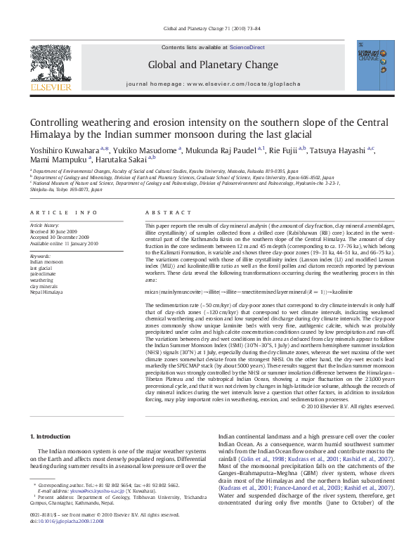
Fig. 1. Outline geological map of the Kathmandu Basin showing the location of the Rabibhawan (RB) core (modified from Sakai, 2001).
of the clay cake formed on the filter was over 15 mg/cm2, which was
adequate for XRD quantitative analysis (Moore and Reynolds, 1989).
The clay cake was then transferred onto a glass slide. For each sample,
both air-dried (AD) and ethylene glycol solvated (EG) preparations
were made. The EG preparation was carried out to expose the sample to
the vapor of the reagent in desiccator for over 8 h at 60 °C. On the other
hand, the non-clay fraction of over 2 µm size was dried and weighed to
estimate the amount of the clay fraction.
All the XRD data were collected on a Rigaku X-ray Diffractometer
RINT 2100 V, using CuKα radiation monochromatized by a curved
graphite crystal in a step of 0.02° with a step-counting time of 4 s.
2.2. XRD decomposition and clay mineral analysis
The decomposition (profile fitting) procedure of Lanson (1997)
was followed to obtain peak position, FWHM, and intensity (peak
area) for each elementary peak, which were used for determination of
the percentages of clay minerals and illite crystallinity. The XRD raw
data were converted into ASCII format, transferred to an Apple Power
Macintosh computer, and treated with a scientific graphical analysis
program XRD MacDiff (Petschick, 2000). Basically, the treatment of a
raw file begins with preliminary smoothing to decrease the effect of
statistical counting errors. Then, a background was subtracted to
eliminate most of its contribution to the peaks. Finally, the elementary
peak fitting was done. All decompositions were performed with
symmetrical elementary peaks with Gaussian shape. Fig. 4 shows a
result of decomposition with five elementary peaks which correspond
to smectite, chlorite, I–S (R = 1), PCI and WCI, for the XRD pattern of
AD sample. To check the reproducibility and detect the errors in the
procedure, the decomposition was repeated four times for an XRD
pattern of each sample and was also performed for four XRD patterns
collected for each given sample. The errors on the measurement of
FWHM and peak area were b1% and b3%, respectively.
The percentage of each clay mineral in the core sediment samples
was determined by the Mineral Intensity Factor (MIF) method (Moore
and Reynolds, 1989):
CMi ð%Þ = 100 × ðIi = MIFi Þ = Σ ðIi = MIFi Þ ði = 1; 2; ⋯nÞ
ð1Þ
�76
Y. Kuwahara et al. / Global and Planetary Change 71 (2010) 73–84
Fig. 3. An age–depth model of the RB core based on the AMS 14C dating (above 30.1 m
depth) and fine tuning of a pollen wet and dry index record to the SPECMAP δ18O stack
record with the LR04 age model (Lisiecki and Raymo, 2005) (below 30.1 m depth)
(Hayashi et al., 2009; Mampuku et al., 2008; Hayashi, 2007).
where MRIi, called Mineral Reference Intensity, is the theoretical
integrated intensity of clay mineral i under specified instrumental
operating conditions. MRI was calculated by the computer program
NEWMOD© (Reynolds and Reynolds, 1996), following the procedure
suggested by Moore and Reynolds (1989). Note that the procedure
forces the analysis to total 100%.
Illite crystallinity was estimated using the LI (Lanson, 1997) and
MLI (Kuwahara et al., 2001). The LI is expressed thus:
LI = 0:1 = ½PCI peak relative intensity × PCI peak FWHM
× ðPCI peak position – WCI peak positionÞ
ð3Þ
where
PCI peak relative intensity
= PCI intensity = ðPCI intensity + WCI intensity + I−S intensityÞ:
ð4Þ
The MLI is defined thus:
MLI = PCI peak relative intensity × PCI peak FWHM
× ðPCI peak position – WCI peak positionÞ
ð5Þ
where
PCI peak relative intensity
ð6Þ
= PCI intensity = ðPCI intensity + WCI intensityÞ:
Fig. 2. A columnar section of the RB core from 5 m to 45 m depth (modified from Sakai,
2001).
It is to be noted that the higher LI and the lower MLI, indicate
higher illite crystallinity.
3. Results
where CMi is the percentage of clay mineral i and Ii is an integrated
peak intensity for clay mineral i. The quantity MIFi is the calibration
constant for the diffraction peak used for clay mineral i that allows for
quantitative estimation of its proportion in a mixture with clay
mineral i', and can be written as:
MIFi = MRIi = MRIi0
ð2Þ
The amount of the clay fraction in the core sediments of the
Kalimati Formation between 12 m and 45 m depth varies between
2 wt.% and 34 wt.%, with an average of 14 wt.%. In the topmost part
between 7 m and 12 m depth, which is composed of the sandy beds of
the Patan Formation and the topmost part of the Kalimati Formation,
the amount of clay fraction is much less (1–8 wt.%, average 5 wt.%)
(Fig. 5a). The Kalimati Formation between 12 m and 45 m depth
�Y. Kuwahara et al. / Global and Planetary Change 71 (2010) 73–84
77
Fig. 4. Decomposition with 5 elementary peaks of the XRD patterns obtained from AD sample of clay minerals in the RB core. The dotted lines represent observed profiles and solid
lines calculated profiles. Gray lines represent the residuum.
consists of three clay-poor zones (17.8–22.0 m, 30.8–33.2 m and
41.1–44.8 m in depth) in which the amount of clay minerals is almost
less than the average, except in some thin clay-enriched parts. The
poorest part of the clay fraction in the clay-poor zones is at 19.6–
22.0 m depth. In the other zones, the clay fraction varies around the
average (14 wt.%) at relatively short intervals (0.4–1 m), with some
clay-rich peaks (N20 wt.%).
The clay minerals in the core sediments include illite, kaolinite,
chlorite, I–S (R = 1), and smectite (Figs. 5c and 6). Among these, illite
is the most dominant one (50–80% in the clay fraction, average 61%),
followed by kaolinite (7–30% in the clay fraction, average 19%). The
morphology and crystal structure (polytype) of illite in the basin
sediments clearly suggest that the illite is detrital (Kuwahara, 2006).
The curve depicting the variations in the percentage of illite is a mirror
image of the corresponding curve for kaolinite. Chlorite (3–9% in the
clay fraction), I–S (R = 1) (4–12% in the clay fraction), and smectite
(traces to 8% in the clay fraction) are of lesser importance in the clay
fraction. In addition, the amounts of the three clay minerals “in the
sediments” are extremely low; it is particularly so of smectite whose
amount does not reach even 1 wt.% (Fig. 5d). Besides the clay
minerals, the sediments are composed of detrital and precipitated
minerals (quartz, feldspars, micas, calcite) (Paudel et al., 2004),
amorphous silica (diatom shell) (Hayashi, 2007; Hayashi et al., 2009),
and organic materials (Mampuku et al., 2008).
The illite crystallinity indices (LI and MLI) also appear to vary in
accordance with the variations in the amount of the clay fraction or of
illite and kaolinite (Fig. 5b). The MLI in the Kalimati Formation varies
between 0.1 and 0.27, with an average of 0.17. In the high illite
crystallinity zones (17.8–21.7 m, 30.6–33.0 m and 39.8–44.5 m
depth), the MLI is almost less than the average, except in certain
zones where some peaks can be seen denoting slightly high MLI.
These three high illite crystallinity zones overlap the three clay-poor
zones mentioned above. The MLI in the other zones appears to
fluctuate around the average at relatively short intervals (0.4–1 m),
with some high peaks (N0.2) that indicate low illite crystallinity.
4. Discussion
4.1. Weathering and erosion processes in the Kathmandu Basin
The detrital minerals in the Kathmandu Basin sediments are
mostly micas (mainly muscovite), feldspars and quartz for which the
source rocks could have been the gneisses and granites of the
Shivapuri injection complex and weakly metamorphosed rocks of the
Phulchauki Group (Sakai, 2001). Besides these, no other source rock,
such as hydrothermal ore body, which could have contributed clay
minerals, is known from or near the basin. The illitic minerals — the
most dominant clay minerals — in the basin sediments, therefore,
could have been formed by the exfoliation of micas during
weathering, and were eroded and transported from the surrounding
mountains by rainfall and run-off. In the Kalimati Formation, the
percentage of illite in the clay fraction decreases with increase in the
�78
Y. Kuwahara et al. / Global and Planetary Change 71 (2010) 73–84
Fig. 5. Variation records depicting (a) the amounts of clay fractions (b2 µm) in the RB core sediments, (b) illite crystallinity indices (Li and MLI), (c) the percentage of each clay mineral in the clay fraction, and (d) the amount of each clay
mineral in sediments. The clay-poor zones (see text) are shaded.
�Y. Kuwahara et al. / Global and Planetary Change 71 (2010) 73–84
79
Fig. 6. Representative XRD patterns of AD and EG samples of clay minerals in the RB core.
total amount of the clay fraction (Figs. 5a and c, 7(e)). In addition, illite
crystallinity becomes low when the percentage of illite in the clay
fraction decreases (Fig. 7(d); note that the higher MLI indicate lower
illite crystallinity). Hence, while the amount of clay minerals fed to the
Kathmandu Basin, increased with intensification of chemical weathering or hydrolysis, the amount and crystallinity of illite, derived from
parent micas, are expected to have been reduced.
Kaolinite, the other dominant clay mineral in the basin sediments,
and I–S (R = 1) have clear negative correlations with illite (Fig. 7(a)
and (b)). That is, the amount of kaolinite, as also of I–S (R = 1),
increases with decrease in the amount of illite, while the amount of
clay minerals increases in and around the Kathmandu Basin (Figs. 5
and 7). Kaolinite is typical of warm and humid areas with good
drainage conditions (Robert, 2004). Precipitation plays a key role in
mineral deposition by exposing fresh rock and mineral surfaces to
chemical and physical weathering and transporting the eroded
minerals to the depositional basins. Steep continental relief reinforces
the role of precipitation and run-off in chemical weathering and
erosion (Chamley, 1989; Robert, 2004). Therefore, warm and wet
conditions and steep relief in and around the Kathmandu Basin could
have contributed to the formation of kaolinite.
Smectite in the clay fraction has no correlation with illite (Fig. 7
(c)). In addition, the amount of smectite in the Kalimati Formation
does not anywhere reach even 1 wt.% (Fig. 5(d)). Smectite, therefore,
cannot be considered the main clay mineral or the main secondary
clay mineral to have been derived from alteration of illite in the
Kathmandu Basin, although it is also indicative of warm and intense
chemical weathering. This does not, however, contradict that smectite
occurs in areas of low, rather than steep, relief characterized by
alternating episodes of precipitation and aridity (Chamley, 1989;
Robert, 2004).
Based on these facts, the following transformations are inferred to
have taken place in this area during the weathering process:
micas ðmainly muscoviteÞ→illite
ð→illite−smectite mixed layer mineral ðR = 1ÞÞ→kaolinite
Also, during this process, the feldspars must have altered mainly to
kaolinite (Chamley, 1989). With intensification of chemical weathering and consequent erosion in and around the Kathmandu Basin,
hydrolysis and leaching of parent minerals were activated, followed
by degradation of illite — derived from alteration of micas — (lowering
of crystallinity and transformation to I–S), and finally the formation of
kaolinite via illitic minerals (illite and I–S). With the waning of
chemical weathering and erosion, the formation of clay minerals and
the transformation of parent minerals to kaolinite would slow down,
and consequently the clay mineral content in the sediments would
decrease, resulting in a low kaolinite to illite ratio.
Also, the sedimentation rates differ between intensified and
weakened chemical weathering and erosion conditions. Based on the
age–depth model of the RB core (Hayashi et al., 2009; Mampuku et al.,
2008; Hayashi, 2007), the average sedimentation rate in the clay-poor
zone, between 18 m and 22 m depth (ca. 19–31 ka), is estimated to be
about 50 cm/kyr, and that in the clay-rich parts (13–18 m (17–19 ka)
and 22–28 m (31–44 ka)), below and above the clay-poor zone, are
about 100 cm/kyr, twice that in the clay-poor zone (Fig. 8). Unfortunately, the details of the sedimentation rates between 28 m and 45 m
depth (44–76 ka) are unclear because the age between them is based
only on one single datum (tie-point between 47.5 m depth and MIS 5.1
(81 ka) (Hayashi et al., 2009)). However, it is certain that the
sedimentation rate in the clay-rich zone was faster than that in the
clay-poor zone. Supposing that the sedimentation rate in the clay-rich
�80
Y. Kuwahara et al. / Global and Planetary Change 71 (2010) 73–84
Fig. 7. Correlation plots between (a) illite and kaolinite, (b) illite and I–S (R= 1), (c) illite and smectite, (d) illite and MLI, (e) overall clay and illite, and (f) overall clay and kaolinite.
Open marks indicate data points in the clay-poor zones and solid marks indicate those in the other. Symbol “r” in figure is a correlation coefficient, and “F” is a result of F test (F = (n − 2) r2/
(1−r2), where “n” is the number of samples). In this test, random sampling (n = 90 selected from total number, N = 319, between 12 m and 45 m depth) was performed to each
correlation plot to improve the power of F test and to avoid reducing of degrees of freedom in the records (Chelton, 1982). There is a correlation between the two elements when the F value
is larger than the F188 (0.05) = 3.95.
zone below 28 m depth was twice as much as that in the clay-poor zone,
in the same way as above 28 m depth, the former is estimated to be
about 60 cm/kyr and the latter is about 30 cm/kyr (Fig. 8).
In the clay-poor zones corresponding to weakened chemical
weathering and erosion conditions (or dry climate), unique laminite
beds with alternating very thin white calcite-rich and black
carbonaceous clayey layers (20–30 pairs/cm), which are not contradictory to the low sedimentation rates in the clay-poor zones, are
recognized (Sakai, 2001; Paudel et al., 2004; Kuwahara, 2006). Paudel
et al. (2004) and Kuwahara (2006) have reported that the calcite
particles in the laminite beds are very fine (~ 50 µm), euhedral, and
authigenic (precipitated in lake water). The calcite could have been
formed under conditions tranquil enough to facilitate formation of
laminite beds, when calcite concentration in lake water was high
because of low precipitation and run-off and consequent shrinkage of
the Paleo-Kathmandu Lake during dry climates. The fossil diatom
study on the same core yielded similar evidence of falling lake-level
during the dry climate intervals (Hayashi, 2007; Hayashi et al., 2009).
Also, calcite formation was reported by the mineralogical study of the
JW-3 core, which was drilled near the RB core site (Fujii et al., 2001).
Such authigenic calcite in the Kathmandu Basin sediments, therefore,
serves not only as an important indicator of dry climate but also as a
key mineral in correlation of (core) sediments.
4.2. Variations in dry–wet conditions in the Kathmandu Basin and
monsoonal response to insolation forcing
From the results of clay mineral analysis of the Kathmandu Basin
sediments, three main dry climate intervals (clay-poor, high illite
crystallinity, low kaolinite/illite (K/I) ratio zones) and four wet
climate intervals (clay-rich, low illite crystallinity, high K/I ratio
zones) were recognized between 17 and 76 ka. The three dry climate
intervals are estimated to be 19–31 ka, 44–51 ka, and 66–75 ka
(Fig. 8). The records prior to 17 ka (in the topmost part between 7 m
and 12 m depth, which is composed of the sandy beds of the Patan
Formation and the topmost part of the Kalimati Formation) are not
suitable for the reconstruction of paleoclimate. The variation record of
dry–wet climate in and around the Kathmandu Basin depicted by the
clay mineral proxies (e.g., the K/I ratio) is very similar to that revealed
by the pollen analysis of the same core (Fujii et al., 2004) (Fig. 8).
In the variation record of dry–wet climate in this area, one can
observe a strong long-term variation in the 23,000 years precessional
�Y. Kuwahara et al. / Global and Planetary Change 71 (2010) 73–84
Fig. 8. Comparison of the records of pollen dry index (Fujii, et al., 2004) and kaolinite/illite ratio (this study) for the Paleo-Kathmandu Lake sediments with the ISMI (30°N–30°S, 1 July), NHSI (30°N, 1 July), SPECMAP δ18O stack (Imbrie et al.,
1984), δ18O of the planktonic foraminifera G. rubber in sediment cores 88/93KL (Schulz et al., 1998) and Greenland GISP2 δ18O ice record (Blunier and Brook, 2001). The records of pollen dry index and kaolinite/illite ratio are depicted based
on the age model reconstructed using the sedimentation rates below 28 m depth of the RB core and a tie point between 47.5 m depth and 82.5 ka (see text) (solid lines), as well as based on the age–depth model of Hayashi et al. (2009),
Mampuku et al. (2008) and Hayashi (2007) (dotted lines). Changes in sedimentary environment and paleoclimate in and around the Kathmandu Basin are also shown. Climates shown in parentheses in the paleoclimate box were indicated by
Fujii et al. (2004). The dry climate zones are lightly shaded. Paleoclimate in the topmost part that is darkly shaded (8–17 ka) is uncertain (see text).
81
�82
Y. Kuwahara et al. / Global and Planetary Change 71 (2010) 73–84
cycle of solar radiation, as dry maxima are centered around 25, 47 and
70 ka, corresponding to the northern hemisphere summer insolation
(NHSI) signal (Fig. 8). Similar results have been obtained by the δ18O
record of the planktonic foraminifera Globigerinoides ruber (Schulz
et al., 1998) and carbonate content (Leuschner and Sirocko, 2003) in
the sediment cores of the Arabian Sea. The maximum signal at 47 ka is
not seen in the SPECMAP stack or GISP2 δ18O records (Blunier and
Brook, 2001). These signals around Marine Isotope Stage (MIS) 3 may
be of regional significance to Indian monsoonal variability (Schulz
et al., 1998). The dry maximum signal around 25 ka is consistent with
the coldest part, which corresponds to the last glacial maximum
(LGM), as revealed by the pollen analysis of the same core (Fujii et al.,
2004).
Leuschner and Sirocko (2003) constructed an Indian Summer
Monsoon Index (ISMI) that is defined as the insolation difference
between 30°N and 30°S on 1 August, based on the fact that the
modern Indian summer monsoon is mainly driven by low pressure
over the Himalayan–Tibetan Plateau and high pressure over the
southern subtropical Indian Ocean. The ISMI or NHSI signal (21 June,
perihelion) showing the 23,000 years precessional tempo, leads the
global ice volume record as indicated by the SPECMAP stack by several
thousand years (Ruddiman, 2001; Leuschner and Sirocko, 2003;
Wang et al., 2005). Further, Clemens and Prell (2003) show that
Arabian Sea summer monsoon stack and factor lag behind the NHSI
signal (21 June, perihelion) by about 8000 years and behind the ice
volume record by about 3000 years, at the precession band (23 kyr).
Similar results on the long lag of the monsoon record were also
obtained from the windblown lake diatoms in the sediment cores
from the tropical Atlantic Ocean, as a proxy of the North African
monsoon (lagging behind the NHSI (21 June, perihelion) by 5000–
6000 years) (Pokras and Mix, 1987). Ruddiman (1997, 2001),
however, suggests that the net lag of the North African monsoon
signal behind the NHSI (21 June, perihelion) is probably only 1000–
2000 years (not 5000–6000 years) because of the delayed diatom
deposition in the Atlantic Ocean.
The variation records of dry–wet condition in this area, deduced
from clay minerals as well as fossil pollen proxies, appear to follow the
summer insolation with no long lag, especially from the coincidence
of the dry climate zones and the low ISMI and NHSI intervals (Fig. 8)
and the results of the cross-correlation analysis of the NHSI with the
record of the K/I ratio (Fig. 9). The ISMI and NHSI in Fig. 8 were
recalculated using the 1 July summer insolation signal, because
nowadays the summer monsoon precipitation in this area reaches its
peak in July (Meteorological Forecasting Division, Government of
Nepal, 2006). We also show in Fig. 8 variation curves of the K/I ratio
and pollen dry index depicted based on the age model reconstructed
using the sedimentation rates below 28 m depth of the RB core
mentioned above and a tie point between 47.5 m depth and 82.5 ka
corresponding to one of the maxima of the NHSI at 1 July (instead of
81 ka (MIS 5.1)), as well as those depicted using the age–depth model
of Hayashi et al. (2009)), Mampuku et al. (2008) and Hayashi (2007).
Using the summer insolation signal at 21 June, perihelion, the dry–
wet record in this area appears to lag slightly behind the NHSI (by
~1000 years) (Fig 9(b)).
However, the centers (or wet maxima) of the wet climate zones
depicted by the K/I ratio do not always coincide with the NHSI
maxima. The wet interval between 32 and 44 ka leads the NHSI while
the wet interval between 51 and 66 ka appears to lag slightly behind
the NHSI (Fig. 8). These results likely show that the K/I record,
especially during the wet intervals, is not as simple as a direct
response to insolation forcing. Other factors, in addition to insolation
forcing, may play important roles in weathering, erosion, and
sedimentation processes or may complicate paleoclimatic interpretation of clay mineral (e.g., lake level change and lake water flow that
affect the distribution of particle size of minerals or dispersion of clay
minerals).
On the other hand, the dry–wet record leads markedly the
SPECMAP stack (the ice volume record) and δ18O record of the
planktonic foraminifer G. ruber in sediment core of the Arabian Sea
(Schulz et al., 1998) (by about 5000 years) (Figs. 8 and 9(b)). Wang
et al. (2005) suggest that if changes in monsoon strength take place
before changes in ice volume, then monsoon variance is definitely not
driven by changes in high-latitude ice volume. The results of the
present study reveal that the Indian summer monsoon precipitation
Fig. 9. (a) Cross-spectral analyses on the record of kaolinite/illite ratio with the NHSI at 1 July and the SPECMAP δ18O stack. (b) Cross-correlation of the NHSI at 1 July, NHSI at 21 June,
and SPECMAP δ18O stack with the record of kaolinite/illite ratio. These analyses were done using the Analyseries software (Paillard et al., 1996).
�Y. Kuwahara et al. / Global and Planetary Change 71 (2010) 73–84
was strongly controlled by the northern hemisphere summer
insolation or summer insolation difference between the Himalayan–
Tibetan Plateau and subtropical Indian Ocean.
The question that arises here is “Why the long lag of monsoon
behind the summer insolation does not show up in the clay mineral
proxies of this study”? One possibility is that the samples are not from
deep-sea sediments, but from intermontane basin sediments on the
southern slope of the central Himalaya. For instance, the δ18O of
planktonic foraminifera in the sediment cores from the Indian Ocean,
which was interpreted as a monsoon proxy, was certainly affected by
changes in global ice volume as well as the local temperature of the
Ocean water (Ruddiman, 2001). Sediment grain size or planktonic
foraminifera shell flux in the deep-sea sediments was probably
influenced by oceanic conditions (e.g., surface and deep-sea currents,
sea-level, water temperature and chemistry) (Singer, 1984; Chamley,
1989; Tiwari et al., 2006). Such problems or intervention is not
inherent in the monsoon proxies (clay minerals, fossil pollen and
diatom, etc.) of the Kathmandu Basin sediments. In addition, the
detritals would have transported and deposited into the PaleoKathmandu Lake “in an instant” as compared with those of the deepsea sediments, because the basin had a diameter of only about 30 km
and the catchment area of the river is confined to the inside slope of
the basin (Sakai, 2001; Kuwahara et al., 2001). The paleo-lake
sediments of the Kathmandu Basin must allow one to obtain direct
and valuable information on the Indian monsoon variability.
5. Conclusions
The clay mineral study of the Paleo-Kathmandu Lake sediments
reveals how the weathering processes operated in this area, how the
variations in the intensity of weathering and erosion were controlled
by the Indian summer monsoon precipitation, and how the Indian
summer monsoon responded to the summer insolation. During the
wet climate intervals, intense chemical weathering and erosion
promoted the formation of clay minerals, lowered illite crystallinity,
and transformed illite to kaolinite. On the other hand, during the dry
climate intervals, the weakening of chemical weathering and erosion
processes retarded the formation of clay minerals and the transformation of illite to kaolinite. The sedimentation rates during the wet
climate intervals were roughly twice as much as those during the dry
climate intervals. The variation records of dry–wet condition in this
area probably follow the summer insolation with no long lag,
especially during the dry climate zones, whereas the wet maxima of
the wet climate zones somewhat deviate from the strongest insolation
forcing. In contrast, the wet–dry records were far ahead of the
SPECMAP stack (the ice volume record), indicating that the Indian
summer monsoon precipitation was not driven by changes in ice
volume but by the northern hemisphere summer insolation or
summer insolation difference between the Himalayan–Tibetan Plateau and the subtropical Indian Ocean. It is stressed here that the
comparative studies between continental and marine records will
have to be pursued further for a more comprehensive understanding
of the Indian summer monsoon.
Acknowledgements
The authors are grateful to the staff of Nissaku Co (Nepal) Pvt. Ltd.
and Prof. Bishal Nath Upreti of Tribhuvan University for their many
kind help. We also thank anonymous reviewers and the Editor
Thomas M. Cronin for their thorough reviews that improved the
quality of the study. This study was supported in part by the Grant-inAid for Scientific Research (Y. Kuwahara, No.17540457 and H. Sakai,
No.11304030 and No.14340152) from the Japan Society for the
Promotion of Science.
83
References
Anderson, D.M., Prell, W.L., 1993. A 300 kyr record of upwelling off Oman during the
late Quaternary: evidence of the Asian southwest monsoon. Paleoceanography 8,
193–208.
Blunier, T., Brook, E.J., 2001. Timing of millennial-scale climate change in Antarctica and
Greenland during the last glacial period. Science 291, 109–112.
Chamley, H., 1989. Clay sedimentology. Springer-Verlag, Berlin Heidelberg.
Chelton, D.B., 1982. Statistical reliability and the seasonal cycle: comments on “Bottom
pressure measurements across the Antarctic Circumpolar Current and their
relation to the wind”. Deep-Sea Research 29, 1381–1388.
Clemens, S.C., Prell, W.L., 2003. A 350, 000 year summer-monsoon multi-proxy stack
from the Owen Ridge, Northern Arabian Sea. Marine Geology 201, 35–51.
Colin, C., Kissel, C., Blamart, D., Turpin, L., 1998. Magnetic properties of sediments in the
Bay of Bengal and the Andaman Sea: impact of rapid North Atlantic Ocean climatic
events on the strength of the Indian monsoon. Earth and Planetary Science Letters
160, 623–635.
Colin, C., Turpin, L., Bertaux, J., Desprairies, A., Kissel, C., 1999. Erosional history of the
Himalayan and Burman ranges during the last two glacial–interglacial cycles. Earth
and Planetary Science Letters 171, 647–660.
Diester-Haass, L.D., Robert, C., Chamley, H., 1998. Paleoproductivity and climate
variations during sapropel deposition in the Eastern Mediterranean Sea (ODP
Leg 160). In: Emeis, K.C., Robertson, A.H.F. (Eds.), Proceedings of the Ocean
Drilling Program, Scientific Results. Ocean Drilling Program, 160. College Station,
TX, pp. 227–248.
France-Lanord, C., Evans, M., Hurtrez, J.E., Riotte, J., 2003. Annual dissolved fluxes from
Central Nepal rivers: budget of chemical erosion in the Himalayas. Comptes Rendus
Geoscience 335, 1131–1140.
Fujii, R., Kuwahara, Y., Sakai, H., 2001. Mineral composition changes recorded in the
sediments from a 284-m-long drill-well in central part of the Kathmandu Basin,
Nepal. Journal of Nepal Geological Society 25, 63–69.
Fujii, R., Sakai, H., 2001. Palynological study of the drilled sediments from the
Kathmandu Basin and its palaeoclimatic and sedimentological significance. Journal
of Nepal Geological Society 25, 53–61.
Fujii, R., Sakai, H., 2002. Paleoclimatic changes during the last 2.5 myr recorded in the
Kathmandu Basin, Central Nepal Himalayas. Journal of Asian Earth Sciences 20,
255–266.
Fujii, R., Sakai, H., Miyoshi, N., 2004. Fluctuation of Indian monsoon during the last
glacial period revealed by pollen analysis of Kathmandu Basin sediments, Nepal
Himalaya. Himalayan Journal of Sciences 2, 133–134.
Fukuzawa, H., Oi, K., Yamada, K., Iwata, S., Torii, M., 1997. Last 2.5 Ma changes of
atmospheric circulation along the Japan Sea-Chinese Loess Plateau — the
Mediterranean Sea Transect caused by uplift of the Himalayan–Tibetan Plateau.
Journal of Geography 106, 204–248 in Japanese, with English abstr.
Goddu, S.R., Appel, E., Gautam, P., Oches, E.A., Wehland, F., 2007. The lacustrine section
at Lukundol, Kathmandu Basin, Nepal: dating and magnetic fabric aspects. Journal
of Asian Earth Sciences 30, 73–81.
Goodbred Jr., S.L., 2003. Response of the Ganges dispersal system to climate change: a
source-to-sink view since the last interstade. Sedimentary Geology 162, 83–104.
Hayashi, T., 2007. Middle to Late Pleistocene monsoonal environmental changes
reconstructed by fossil diatom analyses of the Paleo-Kathmandu Lake sediments,
Nepal Himalaya. Ph. D. Thesis, Kyushu University. Fukuoka, Japan.
Hayashi, T., Tanimura, Y., Sakai, H., 2007a. Puncticulata versiformis sp Nov and Cyclotella
kathmaduensis sp Nov (Bacillariophyta), new fossil species from Pleistocene
lacustrine sediments, Kathmandu, Nepal Himalaya. Journal of Phycology 43, 304–318.
Hayashi, T., Tanimura, Y., Sakai, H., 2007b. A fossil freshwater Thalassiosira, T-inlandica
sp nov (Bacillariophyta), with semicontinuous cribra and elongated marginal
fultoportulae. Phycologia 46, 353–362.
Hayashi, T., Tanimura, Y., Kuwahara, Y., Ohno, M., Mampuku, M., Fujii, R., Sakai, H.,
Yamanaka, T., Maki, T., Uchida, M., Yahagi, W., Sakai, H., 2009. Ecological variations in
diatom assemblages in the Paleo-Kathmandu Lake linked with global and Indian
monsoon climate changes for the last 600,000 yr. Quaternary Research 72, 377–387.
Igarashi, Y., Yoshida, M., Taabata, H., 1988. History of vegetation and climate in
the Kathmandu Valley. Proceeding of Indian National Science Academy, vol. 54, A4,
pp. 550–563.
Imbrie, J., Hays, J.D., Martinson, D.G., McIntyre, A., Mix, A.C., Morley, J.J., Pisias, N.G., Prell,
W.L., Shackleton, N.J., 1984. The orbital theory of Pleistocene climate: support from
a revised chronology of the marine δ18O record. In: Berger, N.J. (Ed.), Milankovitch
and Climate Part I. Reidel, Dordrecht, pp. 269–305.
Islam, M.R., Begum, S.F., Yamaguchi, Y., Ogawa, K., 2002. Distribution of suspended
sediment in the coastal sea off the Ganges–Brahmaputra River mouth: observation
from TM data. Journal of Marine Systems 32, 307–321.
Ivanochko, T.S., Ganeshram, R.S., Brummer, G.-J.A., Ganssen, G., Jung, S.J.A., Moreton, S.G.,
Kroon, D., 2005. Variations in tropical convection as an amplifier of global climate
change at the millennial scale. Earth and Planetary Science Letter 235, 302–314.
Kübler, B., 1964. Les argiles, Indicateurs de metamorphisme. Revue De L'institut
Français Du Pétrole 19, 1093–1112 in French, with English abstr.
Kudrass, H.R., Hofmann, A., Doose, H., Emeis, K., Erlenkeuser, H., 2001. Modulation and
amplification of climatic changes in the Northern Hemisphere by the Indian
summer monsoon during the past 80 k.y. Geology 29, 63–66.
Kuwahara, Y., 2006. Reconstruction of paleoclimate recorded in clay minerals. Nendo
Kagaku (Clay Science) 45, 211–219 (in Japanese).
Kuwahara, Y., Fujii, R., Sakai, H., Masudome, Y., 2001. Measurement of crystallinity and
relative amount of clay minerals in the Kathmandu Basin sediments by
decomposition of XRD patterns (profile fitting). Journal of Nepal Geological Society
25, 71–80.
�84
Y. Kuwahara et al. / Global and Planetary Change 71 (2010) 73–84
Lamy, F., Klump, J., Hebbeln, D., Wefer, G., 2000. Late quaternary rapid climate change in
northern Chile. Terra Nova 12, 8–13.
Lanson, B., 1997. Decomposition of experimental X-ray diffraction patterns (profile
fitting): a convenient way to study clay minerals. Clays and Clay Minerals 45,
132–146.
Leuschner, D.C., Sirocko, F., 2003. Orbital insolation forcing of the Indian Monsoon — a
motor for global climate changes? Palaeogeography, Palaeoclimatology, Palaeoecology 197, 83–95.
Lisiecki, L.E., Raymo, M.E., 2005. A Pliocene–Pleistocene stack of 57 globally distributed
benthic δ18O records. Paleoceanography 20, PA1003. doi: 10.1029/2004PA001071.
Maki, T., Fujii, R., Umeda, H., Sakai, H., Hase, Y., Shichi, K., 2004. Paleovegetation and
paleoclimate in the Kathmandu Valley and Lake Baikal during the Late Quaternary.
Himalayan Journal of Sciences 2, 202.
Mampuku, M., Yamanaka, T., Uchida, M., Fujii, R., Maki, T., Sakai, H., 2008. Changes in C3/C-4 vegetation in the continental interior of the Central Himalayas associated
with monsoonal paleoclimatic changes during the last 600 kyr. Climate of the Past
4, 1–9.
Meteorological Forecasting Division, Government of Nepal, 2006. Normal (average)
maximum, minimum temperature (°C) and Rainfall (mm) through 2000. http://
www.mfd.gov.np/index.php 2006.
Moore, D.M., Reynolds Jr., R.C., 1989. X-ray diffraction and the identification and
analysis of clay minerals. Oxford University Press, New York.
Nakagawa, T., Yasuda, Y., Tabata, H., 1996. Pollen morphology of Himalayan Pinus and
Quercus and its importance in palynological studies in Himalayan area. Review of
Palaeobotany and Palynology 91, 317–329.
Overpeck, J., Anderson, D., Trumbone, S., Prell, W.L., 1996. The southwest Indian
Monsoon over the last 18, 000 years. Climate Dynamics 12, 213–225.
Paudel, M.R., Kuwahara, Y., Sakai, H., 2004. Changes in mineral composition and
depositional environments recorded in the present and past basin-fill sediments of
the Kathmandu Valley, central Nepal. Himalayan Journal of Science 2, 222–223.
Paillard, D., Labeyrie, L., Yiou, P., 1996. Macintosh program performs time-series
analysis. EOS 77, 379.
Petschick, R., 2000. MacDiff Ver. 4.2.3, Manual. Geologisch-Paläontrologisches Institut
Johann Wolfgang-Universität Frankfurt am Main Senckenberganlage. Frankfurt am
Main, Germany, pp. 32–34.
Pokras, E.M., Mix, A.C., 1987. Earth's precession cycle and quaternary climatic change in
tropical Africa. Nautre 326, 486–487.
Rashid, H., Flower, B.P., Poore, R.Z., Quinn, T.M., 2007. A 25 ka Indian Ocean monsoon
variability recorded from the Andaman Sea. Quaternary Science Reviews 26,
2586–2597.
Reynolds Jr., R.C., Reynolds III, R.C., 1996. NEWMOD-FOR-WINDOWS™. In: Reynolds Jr.,
R.C., Reynolds III, R.C. (Eds.), The calculation of One-dimensional X-ray diffraction
patterns of mixed-layered minerals, vol. 03755. 8 Brook Road, Hanover NEW
Hampshire, pp. 1–25.
Robert, C., 2004. Late Quaternary variability of precipitation in Southern California and
climatic implications: clay mineral evidence from the Santa Barbara Basin, ODP Site
893. Quaternary Science Reviews 23, 1029–1040.
Robert, C., Kennett, J.P., 1994. Antarctic subtropical humid episode at the Paleocene–
Eocene boundary: clay mineral evidence. Geology 22, 211–214.
Ruddiman, W.F., 1997. Tropical Atlantic terrigenous fluxes since 25, 000 years B.P.
Marine Geology 136, 189–207.
Ruddiman, W.F., 2001. Earth's Climate, Past and Future. W.H. Freeman and Company,
New York.
Sakai, H., 2001. The Kathmandu Basin: an archive of Himalayan uplift and past monsoon
climate. Journal of Nepal Geological Society 25, 1–8.
Sakai, H., Fujii, R., Kuwahara, Y., 2001a. Changes of depositional system of the PalaeoKathmandu Lake caused by uplifting of the Nepal Lesser Himalayas. Journal of Asian
Earth Sciences 20, 267–276.
Sakai, H., Fujii, R., Kuwahara, Y., Upreti, B.N., Shrestha, S.D., 2001b. Core drilling of the
basin-fill sediments in the Kathmandu Valley for palaeoclimatic study: preliminary
results. Journal of Nepal Geological Society 25, 9–18.
Shakun, J.D., Burns, S.J., Fleitmann, D., Kramers, J., Matter, A., Al-Subary, A., 2007. A highresolution, absolute-dated deglacial speleothem record of Indian Ocean climate
from Socotra Island, Yemen. Earth and Planetary Science Letters 259, 442–456.
Schulz, H., von Rad, U., Erlenkeuser, H., 1998. Correlation between Arabian Sea and
Greenland climate oscillations of the past 110, 000 years. Nature 393, 54–57.
Singer, A., 1984. The paleoclimatic Interpretation of Clay Minerals in sediments — a
review. Earth-Science Reviews 21, 251–293.
Sinha, A., Cannariato, K.G., Stott, L.D., Li, H.-C., You, C.-F., Cheng, H., Edwards, R.L., Singh,
I.B., 2005. Variability of southwest Indian summer monsoon precipitation during
the Bølling-Allerød. Geology 33, 813–816.
Sirocko, F., Sarnthein, M., Lange, H., Erlenkeuser, H., 1991. Glacial to interglacial changes
in Arabian Sea sediment accumulation rates: history of atmospheric summer
circulation and coastal upwelling over the last 30, 000 years. Quaternary Research
36, 72–93.
Sirocko, F., Sarnthein, M., Erlenkeuser, H., Lange, H., Arnald, M., Duplessy, J.C., 1993.
Century-scale events in monsoonal climate over the past 24, 000 years. Nature 364,
322–324.
Sirocko, F., Garbe-Schönberg, D., Devey, C., 2000. Geochemistry of Arabian Sea
sediments during the last 25, 000 years. Global and Planetary Change 26, 217–303.
Srodon, J., 1979. Correlation between coal and clay diagenesis in the Carboniferous
of the Upper Silesian Coal Basin. Proceedings of the International Clay Conference,
pp. 251–260. Oxford.
Srodon, J., Eberl, D.D., 1984. Illite. In: Bailey, S.W. (Ed.), Micas. : Reviews in Mineralogy,
vol. 13. Mineralogical Society of America, pp. 495–544.
Tiwari, M., Ramesh, R., Somayajulu, B.L.K., Jull, A.J.T., Burr, G.S., 2006. Paleomonsoon
precipitation deduced from a sediment core from the equatorial Indian Ocean. GeoMarine Letters 26, 23–30.
Wang, P., Clemens, S., Beaufort, L., Braconnot, P., Ganssen, G., Jian, Z., Kershaw, P.,
Sarnthein, M., 2005. Evolution and variability of the Asian monsoon system: state of
the art and outstanding issues. Quaternary Science Reviews 24, 595–629.
Yoshida, M., Igarashi, Y., 1984. Neogene to Quaternary lacustrine sediments in the
Kathmandu Valley, Nepal. Journal of Nepal Geological Society 4, 73–100.
�
 Mukunda Paudel