GEOPHYSICAL RESEARCH LETTERS, VOL. 32, L08501, doi:10.1029/2005GL022519, 2005
Seasonal variation in velocity before retreat of Jakobshavn Isbræ,
Greenland
Adrian Luckman and Tavi Murray1
Department of Geography, Swansea University, Swansea, UK
Received 22 January 2005; revised 1 March 2005; accepted 9 March 2005; published 16 April 2005.
[1] Using repeat-pass satellite feature tracking, the
dynamic behaviour of Jakobshavn Isbræ, which drains
around 7% of the Greenland ice sheet, is investigated in
improved detail through its recent period of thinning,
acceleration and retreat. The departure in 1995 from the
normal seasonal invariance in velocity near the grounding
line suggests a possible change in dynamics well before the
subsequent thinning phase. The initiation of the acceleration
and retreat is pinpointed to spring 1998 and may have
been prompted by the same mechanism that gave rise to
the spring 1995 flow increase. Citation: Luckman, A., and
T. Murray (2005), Seasonal variation in velocity before retreat
of Jakobshavn Isbræ, Greenland, Geophys. Res. Lett., 32,
L08501, doi:10.1029/2005GL022519.
1. Introduction
[2] Jakobshavn Isbræ, Greenland’s most active outlet
glacier, has received much attention because it drains
a significant part of the ice sheet and has exhibited a
consistently high and seasonally invariant rate of flow
[Echelmeyer and Harrison, 1990]. Its recent thinning,
acceleration and retreat has focussed even more attention
on the response of the ice sheet to climate warming
[Thomas et al., 2003; Joughin et al., 2004]. In this paper
we use feature tracking between repeat-pass satellite SAR
images to investigate in more detail the dynamics of this
outlet glacier through the recent period of thinning and
acceleration.
2. Summary of Recent Observations
[3] The recent nature and behaviour of Jakobshavn Isbræ
has hitherto been investigated through borehole measurements [e.g., Iken et al., 1993; Lüthi et al., 2002], spaceborne
observations of frontal position [e.g., Sohn et al., 1998],
airborne surveys of surface elevation [e.g. Thomas et al.,
2003] and remote sensing analyses of surface velocity [e.g.,
Joughin et al., 2004]. From the 1960’s to the 1990’s the
frontal position showed regular, seasonal fluctuations suggesting that calving flux is controlled either by the restraining influence of winter fjord-ice or by the availability of
surface summer meltwater [Sohn et al., 1998]. Sporadic
thickening in the lower part of the ice stream was detected
between 1991 and 1997, despite locally warm summers.
This was followed by a period of thinning which continued
1
Formerly at School of Geography, University of Leeds, Leeds, UK.
Copyright 2005 by the American Geophysical Union.
0094-8276/05/2005GL022519
for at least the next three years and which must have been
dynamic in nature [Thomas et al., 2003]. More recently, the
surface velocity of the ice stream was shown to have
increased dramatically between 1997 and 2000 and to have
continued to escalate into 2003, accompanied by the breakup of the floating tongue [Joughin et al., 2004]. The
potentially complex interactions between thinning, retreat
and acceleration are interesting in that they may signify a
more general response of such outlets to climate warming
[Thomas, 2004; Zwally et al., 2002].
[4] Prior to 2000, reported variations in flow rate on
Jakobshavn Isbræ include those related to tides [Echelmeyer
and Harrison, 1990], a moderate slow-down between 1985
and 1992 consistent with the observed thickening [Joughin
et al., 2004] and a modest variation just outside of the ice
stream margin between July 1995 and May 1996 [Lüthi
et al., 2002]. Despite evidence that supraglacial lakes in
the ablation zone can drain quickly through crevasses
[Echelmeyer and Harrison, 1990; Prescott et al., 2003],
the distinct lack of seasonal variations, even downstream
of the grounding line and within 15 km of a fluctuating
calving front, has been one of the defining characteristics
of this ice stream [Pelto and Hughes, 1989; Echelmeyer
and Harrison, 1990]. Consequently the flow regime has
been interpreted as being dominated by internal deformation which is enhanced because of a thick layer of
warm pre-Holocene ice [Funk et al., 1994; Lüthi et al.,
2002].
[ 5 ] The crevassing associated with the margins of
Jakobshavn Isbræ is extensive for a long way upstream
[Echelmeyer et al., 1991; Herzfeld and Mayer, 2003]. This
study was aimed at exploring the recent surface velocity
variations of the ice stream by exploiting the archive of
ERS SAR imagery which is both sensitive to such
surface features and more frequently available than optical data.
3. Methods and Data
[6] The use of correlation-based feature-tracking between
repeat-pass airborne or spaceborne images is well established both for optical imagery [e.g., Bindschadler and
Scambos, 1991; Scambos et al., 1992] and Synthetic Aperture Radar (SAR) imagery [e.g., Lucchitta et al., 1995;
Strozzi et al., 2002; Rignot et al., 2004]. Whilst specklebased tracking and coherence-based tracking may be used
to derive high resolution velocity fields from pairs of SAR
images possessing phase coherence [Joughin, 2002; Strozzi
et al., 2002], tracking of detectable features in SAR
backscatter intensity images, such as crevasses, may also
yield useful surface flow measurements [Lucchitta et al.,
L08501
1 of 4
�L08501
LUCKMAN AND MURRAY: JAKOBSHAVN ISBRÆ SEASONAL VARIATION
L08501
1995; Luckman et al., 2003; H. Pritchard et al., Glacier
surge dynamics of Sortebræ, East Greenland, from synthetic aperture radar feature tracking, submitted to Journal
of Geophysical Research, 2005]. This technique is more
limited in spatial resolution and coverage but allows pairs
of images separated by a full satellite orbital cycle to be
used where such surface features exist, thereby increasing
the periods available for velocity measurement.
[7] In this study, a large proportion of the available
archived 35-day repeat-track pairs of ESA ERS-SAR
images of Jakobshavn Isbræ were acquired and used to
derive surface velocity fields during the 1990s. These
include a single image pair from 1992, nine consecutive
images spanning the summer and early winter of 1995 to
1996, and between one and three image pairs for each of
the years 1996 to 2000, all from one of two satellite
tracks.
[8] The feature-tracking technique adopted here follows
the normal procedure of deriving the field of 2D offsets
between each pair of images and removing the flowindependent image-to-image mapping to leave only the
displacements due to ice flow. Offsets are determined by
finding the peak position of the intensity correlation field
between regularly spaced image patches, each covering
around 1 km by 1 km of the scene. The flow-independent
part is determined in a similar way but by considering only
exposed rock features within the images to define a secondorder 2D mapping between them. Since rock outcrops occur
only beside the final 15 km of Jakobshavn Isbræ, the error
in this correction is expected to increase further upstream.
Correlation signal-to-noise ratios are used to reject poor
matches, resulting in a sequence of patchy grids of 2D
velocity information where surface features are moving
coherently. These grids are geocoded and terrain-corrected
to a UTM projection using a DEM derived from digital map
contours.
[9] Where there are local rock references (i.e. on the
floating tongue and as far as a few km upstream of the
grounding line) errors in this technique are expected to be
around 0.1 pixels over 35 days, or better than 0.1 md�1
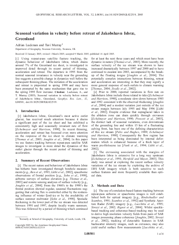
Figure 1. A subset of the 24 Jakobshavn Isbræ velocity
fields derived using feature tracking between pairs of 35day repeat-track ERS-SAR images. This subset was chosen
to show (a) – (c) the abrupt frontal retreat and acceleration in
mid-1998 and (d) the high velocities in 2000. Surface speed
is colour-coded and presented over the backscatter intensity
of the second of the image pair while arrows give the
direction of flow. Grey shades indicate areas lacking
sufficient quality matches either because of a lack of
trackable surface features or because of lack of coherent
motion over the 35-day repeat period. Light blue (0 md�1)
corresponds to exposed rock used as a zero reference for
velocity measurements. Locations of the velocity measurement points used in Figure 2, and of the ‘ice rumple’
[Joughin et al., 2004] are also shown with coloured stars
(A: just downstream of the grounding line estimated in
Prescott et al. [2003], (69°1003000, 49°4702400); B: 30 km
upstream of the grounding line, (69°0802400, 49°0500300); and
R: ‘ice rumple’). The lower right inset shows location of
Jakobshavn Isbræ on the West coast of Greenland (red
rectangle).
2 of 4
�L08501
LUCKMAN AND MURRAY: JAKOBSHAVN ISBRÆ SEASONAL VARIATION
Figure 2. The evolution through the 1990s (a) and (b) of
surface speeds at the two points on Jakobshavn Isbræ shown
in Figure 1 and (c) of the frontal position relative to the
approximate September 2002 position from Joughin et al.
[2004]. Error bars are 0.1 md�1 in (a) (and therefore
negligible), 0.5 md�1 in (b), and 200m in (c).
[Strozzi et al., 2002]. Further upstream, errors cannot be
estimated accurately because there is no way to determine
how the flow-independent image-to-image mapping deteriorates away from rock references. However, correspondences
in velocity minima between the sequences of velocity maps
suggest it is no worse than 0.5 md�1.
4. Observations of Velocity and Frontal Position
[10] In all, 24 maps of velocity spanning the 1990s were
derived, a selected sample of which are presented in
Figure 1. Velocity evolution throughout the sequence
was extracted at two locations, one just downstream
(labelled A) and one about 30 km upstream (labelled B)
of the grounding line, chosen because the signal-to-noise
ratio was sufficient here to determine the velocity throughout the sequence (Figures 2a and 2b). In addition, the
sequence of mid-stream positions of the calving front was
measured from the backscatter intensity images alone
(Figure 2c). We note that throughout the sequence of
images at least the first 20 km of the fjord appeared to
be packed with ice. There was no evidence that this was
not free to move but there was also no evidence of open
water patches within it.
[11] In 1995, where images were available from every
satellite cycle, a seasonal pattern of velocity variation is
apparent. The velocity just downstream of the grounding
line increases from 16 to 18 md�1 from May through to
July, just as meltwater is expected to be available, and then
slowly decreases as winter commences (Figure 2a). The
magnitude of this increase cannot be explained by any tidal
influence on the vertical position of the ice. This seasonal
L08501
pattern is echoed at the second measurement point 30 km
upstream (which is not as far upstream as the borehole sites
of previous studies [Iken et al., 1993; Lüthi et al., 2002]) but
lower velocities and larger errors make the observations
here less conclusive (Figure 2b).
[12] Between March and April 1997, there is a modest
reduction in the velocity just downstream of the grounding
line. This is followed, between April and May 1998, by a
small increase in velocity, accompanied by a significant
early retreat of the front to the normal minimum position of
late-summer, and the calving of large (0.5 –1.0 km2) tabular
icebergs (Figure 1b). Between May 1998 and the next
observation in August, there is a further large retreat to an
unprecedented position, but not beyond the ‘ice rumple’
(Figure 1c), thought to be a possible pinning point [cf.
Joughin et al., 2004]. Note that this retreat and acceleration
coincides with the first observation of thinning of Jakobshavn Isbræ between May 1997 and June 1998 [Thomas et
al., 2003]. Between August and September 1998, the
velocity of the floating tongue increased dramatically to
nearly 20 md�1 while at the upstream measurement point
there is some evidence of a delayed acceleration. These new
data demonstrate more precisely than previously published
the first period of significant acceleration in Jakobshavn
Isbræ [Joughin et al., 2004]. Subsequent velocity measurements are limited to one in 1999 and a sequence of three in
2000 (e.g., Figure 1d). The pattern is one of gradually
increasing velocities, which agree with the observations of
Joughin et al. [2004], and frontal fluctuations between the
new minimum of 1998 and the previously established
summer minimum.
5. Discussion and Conclusion
[13] In contrast to previous observations, the data presented here show a seasonal variation in surface velocity
for Jakobshavn Isbræ during 1995. This might be
explained by a reduction in back pressure in the fjord
resulting from warmer temperatures and reduced sea-ice,
but there is little support in the observed fluctuation in
frontal position which, during 1995, seems to follow the
established 1962 – 1996 pattern [Sohn et al., 1998]. Alternatively, surface meltwater, during this anomalously high
melt year [Abdalati and Steffen, 2001], may have contributed towards higher velocities, possibly through enhanced
basal motion. If so, this may indicate a change of
dynamics for Jakobshavn Isbræ three years before any
significant acceleration or frontal retreat.
[14] Aside from this 1995 anomaly, the first major
increase in velocity from the long-established norm was
observed between March and April 1998, also a high melt
year [Abdalati and Steffen, 2001; Steffen and Box, 2001].
The first departure from the normal pattern of frontal
position was detected only a month later [cf. Sohn et al.,
1998]. It seems likely, therefore, that the modest thinning
measured by Thomas et al. [2003] between May 1997 and
June 1998 occurred mostly between April and June 1998.
This is not unreasonable considering the normal discharge
rates and the surface area of fast flowing ice [Echelmeyer
et al., 1991]. If this is the case then the perturbation of the
ice stream coincided with the onset of spring 1998, is
consistent with the idea of a large calving event [Thomas,
3 of 4
�L08501
LUCKMAN AND MURRAY: JAKOBSHAVN ISBRÆ SEASONAL VARIATION
2004] and may in part have been triggered by the same
changes that gave rise to the seasonal velocity fluctuation
in 1995.
[15] Acknowledgments. We are very grateful to ESA for provision of
SAR data and to A. Shepherd and D. Wingham (Scott Polar Research
Institute) for helping to make this available through the VECTRA project.
We thank the Geological Survey of Denmark and Greenland for provision
of the digital map data. We especially thank the comments of the two
reviewers who played a significant part in improving this paper.
References
Abdalati, W., and K. Steffen (2001), Greenland ice sheet melt extent:
1979 – 1999, J. Geophys. Res., 106(D24), 33,983 – 33,988.
Bindschadler, R. A., and T. A. Scambos (1991), Satellite-image-derived
velocity field of an Antarctic ice stream, Science, 252, 242 – 246.
Echelmeyer, K., and W. D. Harrison (1990), Jakobshavn Isbræ, West
Greenland: Seasonal variations in velocity - or lack thereof, J. Glaciol.,
36(122), 82 – 88.
Echelmeyer, K., T. S. Clarke, and W. D. Harrison (1991), Surficial glaciology of Jakobshavns Isbræ, West Greenland: Part 1. Surface morphology,
J. Glaciol., 37(127), 368 – 382.
Funk, M., K. Echelmeyer, and A. Iken (1994), Mechanisms of fast-flow
in Jakobshavns Isbræ, West Greenland, part II, Modelling of englacial
temperatures, J. Glaciol., 40(136), 569 – 585.
Herzfeld, U. C., and H. Mayer (2003), Seasonal comparison of ice-surface
structures in the ablation area of Jakobshavn Isbræ drainage system, West
Greenland, Ann. Glaciol., 37, 199 – 206.
Iken, A., K. Echelmeyer, W. Harrison, and M. Funk (1993), Mechanisms
of fast-flow in Jakobshavns Isbræ, West Greenland, part I, Measurements of temperature and water-level in deep boreholes, J. Glaciol.,
39(131), 15 – 25.
Joughin, I. (2002), Ice-sheet velocity mapping: A combined interferometric
and speckle-tracking approach, Ann. Glaciol., 34, 195 – 201.
Joughin, I., W. Abdalati, and M. Fahnestock (2004), Large fluctuations in
speed on Jakobshavn Isbræ, Greenland, Nature, 432, 608 – 610.
Lucchitta, B. K., C. E. Rosanova, and K. F. Mullins (1995), Velocities of
Pine Island glacier, West Antarctica, from ERS-1 SAR images, Ann.
Glaciol., 21, 277 – 283.
Luckman, A., T. Murray, H. Jiskoot, H. D. Pritchard, and T. Strozzi (2003),
Automatic ERS SAR feature-tracking measurement of outlet glacier
L08501
velocities on a regional scale in East Greenland, Ann. Glaciol., 36,
129 – 134.
Lüthi, M., M. Funk, A. Iken, S. Gogineni, and M. Truffer (2002),
Mechanisms of fast flow in Jakobshavn Isbræ, West Greenland: Part
III. Measurements of ice deformation, temperature and cross-borehole
conductivity in boreholes to the bedrock, J. Glaciol., 48(162), 369 –
385.
Pelto, M. S., and T. J. Hughes (1989), Equilibrium state of Jakobshavn
Isbræ, West Greenland, Ann. Glaciol., 12, 127 – 131.
Prescott, P. R., J. P. Kenneally, and T. J. Hughes (2003), Relating crevassing
to non-linear strain in the floating part of Jakobshavn Isbræ, West Greenland, Ann. Glaciol., 36, 149 – 156.
Rignot, E., D. Braaten, S. P. Gogineni, W. B. Krabill, and J. R. McConnell
(2004), Rapid ice discharge from southeast Greenland glaciers, Geophys.
Res. Lett., 31, L10401, doi:10.1029/2004GL019474.
Scambos, T. A., M. J. Dutkiewicz, J. C. Wilson, and R. A. Bindschadler
(1992), Application of image cross-correlation to the measurement of
glacier velocity using satellite image data, Remote Sens. Environ., 42,
177 – 186.
Sohn, H.-G., K. C. Jezek, and C. J. van der Veen (1998), Jakobshavns
Glacier, West Greenland: 30 years of spaceborne observations, Geophys.
Res. Lett., 25(14), 2699 – 2702.
Steffen, K., and J. Box (2001), Surface climatology of the Greenland ice
sheet: Greenland climate network 1995 – 1999, J. Geophys. Res.,
106(D24), 33,951 – 33,964.
Strozzi, T., A. Luckman, and T. Murray (2002), Glacier motion estimation
using satellite-radar offset-tracking procedures, IEEE Trans. Geosci.
Remote Sens., 40(11), 2384 – 2391.
Thomas, R. H. (2004), Force-perturbation analysis of recent thinning
and acceleration of Jakobshavn Isbræ, Greenland, J. Glaciol., 50(168),
57 – 66.
Thomas, R. H., W. Abdalati, E. Frederick, W. B. Krabill, S. Manizade,
and K. Steffen (2003), Investigation of surface melting and dynamic
thinning on Jakobshavn Isbræ, Greenland, J. Glaciol., 49(165), 231 –
239.
Zwally, H. J., W. Abdalati, T. Herring, K. Larson, J. Saba, and K. Steffen
(2002), Surface melt-induced acceleration of Greenland ice-sheet flow,
Science, 297, 218 – 222.
����������������������
A. Luckman and T. Murray, Department of Geography, Swansea
University, Swansea SA2 8PP, UK. (a.luckman@swansea.ac.uk)
4 of 4
�
 Tavi Murray