Nucl. Tracks, VoL 3, pp. 213-218
Pergamon Press Ltd. 1979. Printed in Great Britain
R A D I O A C T I V E S U R V E Y O F K I R A N A HILLS U S I N G
S O L I D STATE N U C L E A R TRACK D E T E C T O R S
N. A. KHAN,N. A. MAHMOODand M. A. KHALIQ
Physics Department, Talim-ul-Islam College, Rabwah, Pakistan
(Received 14 March 1979; in revised form 21 June 1979)
Abstract--Radioactive survey of an area of Kirana hills (Pakistan) has been carried out by using Solid
State Nuclear Track Detectors (SSNTDs). The track density has been observed to indicate contour
variations. The results have been compared with the count rate obtained by using a G-M counter, and
an excellent agreement has been obtained.
1. I N T R O D U C T I O N
SOLID State Nuclear Track Detectors (SSNTDs)
have been employed for the initial exploration of
uranium and other radioactive elements. The method essentially consists in the detection of the three
radon isotopes which are the products of decay of
the naturally-occurring radioactive series. Only one
of these isotopes of radon, namely 222Rn, which is
one of the daughters of uranium decay, is really helpful
since the other two isotopes are short-lived and
cannot diffuse out of the rock surface from the
entrapped mineral. Tanner (1975) has estimated
that 222Rn, diffusing from a plain source through
dry sand, can travel about 7 m before suffering a
hundredfold decrease in concentration by radioactive decay.
Miller (1973) has pointed out that, since radon
prospecting is concerned with a dynamic system
depending upon a number of variables, interpretation of results is difficult. Before 1960, exploration
of uranium was mainly carried out by the application of surface gamma radioactivity measurement.
The discovery of new deposits in further uranium
exploration is going to be more difficult, since they
may be buried deep down and there may not be
any appreciable surface gamma activity. New methods of investigation must be developed, including
those involving radon measurements, which can be
applied even to ore bodies having very little sur-
face gamma activity. Since radon does not combine
with other elements, its free migration through pore
spaces in rock and soil is possible. A radon atom
diffuses through the enclosing mineral if the parent
radium is close to the grain surface. Having escaped
from a mineral, radon will diffuse through the
ground air in pore spaces, and the long-lived 222Rn
may travel up to several metres. Besides diffusion,
there are other means by which radon is transported, such as low pressure and strong winds which
may draw ground air out of the pore spaces, thus
causing an upward movement of the gas from
depth.
Previously, alpha detection was done by chambers coated with alpha-sensitive phosphors. Probes
and pump monitors for measuring radon in soil air
have been described by Miller (1973). Detection of
alpha activity by solid state nuclear track detectors
has the advantages of simplicity, low cost and
greater sensitivity. Also these detectors are insensitive to beta particles, gamma rays and light.
2. APPLICATION O F PLASTIC DETECTORS
Gamma-sensitive techniques are effective only
where the uranium mineralization is at, or very
near, the surface. In many areas of the world where
uranium is being explored, surface scintillation techniques are not effective, because all targets of interest are deeply buried. The only effective method
213
�214
N. A. KHAN, N. A. M A H M O O D and M. A. KHALIQ
of exploring in these areas are drilling techniques,
which require thorough interpretation of the subsurface geology. Radon-detecting techniques offer
an inexpensive prospection method of uranium mineralization buried several hundred metres deep
(Gingrich and Fisher, 1973).
The track-etch method based on the utilization of
small or-radiation-sensitive solid-state plastic detectors gives an accumulated picture of changing radon soil-gas concentration and produces a reading
indicative of the long-term average. To obtain the
maximum amount of information from track-etch
reading, the data are presented in the form of radon
contour maps or graphs. Gingrich and Fisher
(1973) have estimated that radon is an extremely
small component of soil gas (0.66x 10 -18 1 Rn/l).
Transport velocities of the order of (4-6 × 10⁻³cm
s-~ or approximately 3-5 m per day have been
suggested. Using the lower figure of 3 m per day
and a soil containing 1 ppm U overlying 2000 ppm
ore body, an anomaly 3 times the value of the
background should be produced over the ore body
if it were buried 120 m deep.
Gingrich and Fisher (1973) have surveyed the use
of the track-etch system for uranium exploration in
about 300 programmes in a wide variety of geological environments. Most of the initial surveys were
made in the sedimentary deposits area of Western
United States, and in the vein type deposits of
Australia. Several successful programmes are also
reported to have been carried out in Canada and
Africa.
The track-etch technique for uranium has been
found to be particularly attractive for preliminary
survey, and for conducting exploration in remote
areas where only a limited amount of field support
is available. This system can result in significant
savings in exploration drilling costs, and has been
found to operate in any terrain from tropical areas
of Australia to permafrost-covered arctic regions of
Canada.
3. FIELD C O N D I T I O N S IN KIRANA HILLS
We have chosen an area for investigation which
is situated in Rachna and Chhaj Doabs on either
side of river Chenab (32 ° North latitude). This level
plain is largely made of fertile alluvium deposited
by the river. Most of the area is 600-650 ft
*Manufactured by Kodak-Path~ of France.
(~200m) above sea-level. The average gradient is 1
ft to 1 mile (i.e. ~ 20 cm to 1 kin).
The only breaks in the alluvial monotony of the
plain are the little groups of arid, broken hills of
sedimentary rocks near Sangla, Chiniot, Rabwah
and Sargodha. These are known as Kirana Hills
and are only ~ 100 km from the Salt Range. Their
rigidity is shown by the occurrence of horst structure. These are very small in extent, but rise in
jagged pinnacles 300m above the plains and are
geomorphologically of great interest, as they provide an evidence of the extension of the old
Gondwana Block (Wadia, 1966).
The Kirana Hills belong to the Aravalli range
which starts from Delhi and covers a part of
Rajasthan province in India. Uranium--copper mineralization has been found on the western bank of
Aravalli meta-sediments in Udaipur District of
Rajasthan. Uranium ore occurs as lenses of variable
size on the foot-wall side of the copper zone. The
deposit is, however, economically unimportant.
Low-grade uranium has also been found in the
Alwar District. But this, again, is not fit for exploitation, as the grade goes only from 0.01 to 1.33%
equivalent U30 8. The Jhunjhunu District also contains some uranium mineralization, but the analysed
samples contain only up to 0.07 % equivalent U30 s.
In the Kulu District of the Indian Punjab, which
lies at the foot of the Himalayas, uranium in
quartzite was found recently on the western slopes of
the Shakiran Dhar. A full review of uranium and
thorium deposits in India has been made by Bhola
et al. (1975). They estimate large deposits of monazite in Rajasthan, which contain from 8 to 10'%
ThO2 and up to 0.3'~ U 3 0 8. The use of thorium in
breeder reactors opens up possibilities of utilizing
monazite in connection with nuclear power plants.
Since Kirana Hills are a part of the Aravalli
range, there is a possibility of these hills containing
uranium/thorium mineralization. The initial survey
of a small area of these hills has indicated the
presence of some interesting anomalies. Further
tests are in progress.
4. EXPERIMENTAL RESULTS A N D
DISCUSSION
Nuclear track detectors CA80-15", and rarely LR115", were placed in a grid of approx. 3 0 x 3 0 m
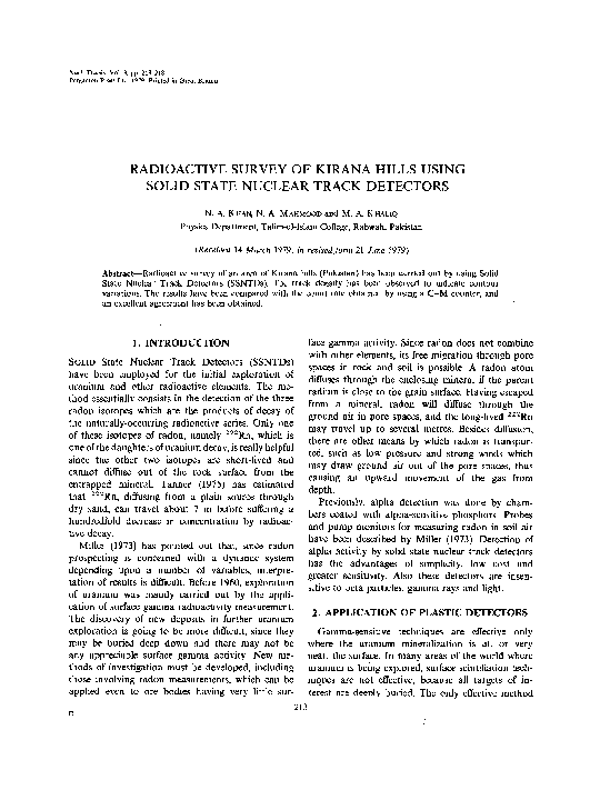
�RADIOACTIVE SURVEY OF KIRANA HILLS USING SSNTDs
anomalies found in the first survey were confirmed
on subsequent measurements. T h e Fig. 1 contour
map shows the result of these measurements. It can
be seen that alpha activity in some of the rocks is
greater by a factor of six than activity at other
points. The anomaly may indicate the presence of
uranium mineralization at some depth below the
surface of these rocks. The part marked × in the
contour map (Fig. 1) shows an additional area
surveyed recently, for the purpose of comparing
radon concentration in plain surface consisting of
sand and clay with the values in rocks.
within a maximum distance of about 1000m
from the Nuclear Research Laboratory of the
Talim-ul-Islam College. An exposure of 60 days was
made, the average depth of holes being about 7080cm. Plastic detectors were attached to the lower
sides of the roof surface of inverted small sampling'
cups of diameters varying from 2.5 to 3cm that
were placed in holes in the ground. At the end of
the exposure time, the cups were recovered and the
detectors were etched in 40% NaOH solution for
120 rain at a temperature of (50+2)°C. After
etching, the detectors were placed under a high
magnification microscope for counting the track
density. A maximum track density of 2.2× l0 s
cm -2 has been found. Places where radon activity
was found higher than that of other points were subjected to this radioactive survey several times, both
in winter and in summer. Track density was found
to be higher in summer than in winter. The difference in the maximum values was as high as 30%.
The object of repeated surveys was to locate positions where the radon activity is maximum. The
Chemical composition
Samples of rock and soil were sent for analysis to
the Atomic Energy Minerals Centre at Lahore. The
rock sample was found to be of quartzite with 95 %
SiO 2 and minor quantities of Fe, Ca, K, Na, etc.
Soil samples appeared to be mostly high-alumina
clay. No appreciable amounts of radioactive elements were detected by gamma-spectrometry. The
AhrnadNagar
~
/
I
-
/
~
~,
215
i
r
C._.q~__
Shah
/
~ 0 C~) NuclearResearchLaboratory
o
,oo
200 300
Metres
FIG. 1. Contour map showing alpha activity (using plastic SSNTDs) over the area under survey.
�216
N.A. KHAN, N. A. MAHMOOD and M. A. KHALIQ
Ahmad Nagar
Kot Amir Shah
yard
[,
~f
I
~
SargodhaRood
~
~
Railway line
S
X
FIG. 2.
0
,,~
0 I00 200 300
Metres
NuclearResearchLaboratory
Contour m a p showing g a m m a activity (using G - M counter) over the area under survey.
220
For alpha activity
-'-
180
For gamma activity
140
g
I00
20
I
I
I
1
I
I
300
400
500
600
700
800
Distance, meters
FIG. 3. Variation of g a m m a and alpha activity with distance. G a m m a activity:
102N rain-~; alpha activity: 103N c m - 2 ; where N is the number of counts shown,
�RADIOACTIVE SURVEY OF KIRANA HILLS USING SSNTDs
composition of these sedimentary rocks may be
compared with Arenaceous type (Davies, 1949;
Pettijohn, 1949).
Gamma activity
The anomalies found in the investigation mentioned above were interesting, and we wanted to
know if there were corresponding variations in
gamma activity. The area surveyed was therefore
subjected to the measurement of its gamma activity
by a Geiger-M011er counter assembly. The results
of this measurement are shown in the Fig. 2
contour map. We have plotted in Fig. 3 the values
of alpha activity measured by the plastic detectors as
well as the gamma activity determined with the G M counter. The correspondence between the two
activities is striking. The same correlation is expressed in another way in Fig. 4. The origin in the
graphs as well as in the contour maps is the
position of the Nuclear Research Laboratory, of the
Department of Physics at the New Campus of our
College.
80095
=70
084 5o2.65
217
5. CONCLUSION
The initial survey of a small part of Kirana Hills
shows interesting anomalies in radon concentration in these rocks and may indicate the presence
of significant amounts of radioactive minerals.
Moreover, the alpha activity has been found generally to be more in rock than in soil. Also, there
is a marked effect of weather shown by a 30%
increase in track density in summer as compared
with that in winter. The continuous dust storm and
strong winds in the hot summer months, which are
characteristic of this area, may be responsible for
the increased migration upward of radon from the
subsurface rock and soil. Since the chemical analysis of the upper-surface rock and soil did not
show marked presence of radioactive substances,
the close correspondence between alpha and gamma
activity in the area under survey is an important
point needing further investigation.
The area surveyed is small. Need for a full-scale
investigation is obvious. We propose to cover the
whole Kirana range as far as possible.
N
u~
4°5"4o9.45
60
4o,5e65
4565
®056
50
. 0 8 0 48
- 800
o For alpha particles
8
75
50.7o
® For gamma particles
E
Q
.m
%8p8- 6oo o
o e70
65 56
•
IO00o
92
40
, o
921
Nuclear Research Laboratory
o9_ 150 __
4b
o ®rb
6 3, o6o.88
o ~ 5 ~ " 4 0 0 " o160
162o ®67
7 8 . o 900 ®465
ioo ~ 1
~%o
,..®~o56
1201
v'*
70 66o
o
®
70
®
~-6o2o~®38
8o
223 °
4O
-- 2 0 0
® 049 4o3 42o
• 48 e45
o,o%2
C ~)
l
200
351
400
I
I
I
1
I
600
800
I000
1200
1400
Distance,
E
meters
4008042a0%8050
s
A°7°t7°6°
FIG. 4. Correlation between gamma and alpha activity. Numerical figures represent number of
counts. Gamma activity: 102Nmin- 1; alpha activity: 103Ncm-2; where N is the number of
counts.
�218
N. A. K H A N , N. A. M A H M O O D
We have submitted a research project to the
P a k i s t a n Science F o u n d a t i o n (PSF) for financial
support. The project is under the active consideration of P S F and we hope to start a systematic
survey of the entire range.
Acknowledgements--We thank Dr Hameed Ahmad
Khan and Mr Riaz Ahmed Akbar of PINSTECH for their
help in the form of detectors and useful information at the
initial stages of our work.
We gratefully acknowledge the donation of two boxes of
detectors and some literature by the Fund for Physics for
Developing Countries established by Professor Abdus
Salam, Director, International Centre for Theoretical
Physics, Trieste, Italy.
Mr Hamid Ali, M.A., lecturer in geography at the T.I.
College is thanked for many useful discussions.
a n d M. A. K H A L I Q
REFERENCES
Bhola K. L., Dar K. K., Rama Y. A., Sastor C. and
Mehta N. R. (1975) A review of uranium and
thorium deposits in India. In Proc. Uranium and
Thorium Research and Resources Conf. (8-10
December 1975). U.S. Geological Survey, pp. 86-93.
Davies G. M. (1949) A Student's Introduction to Geology.
Thomas Murby and Co., London.
Gingrich J. E. and Fisher J. C. (1973) Uranium explorations using the track-etch method. IAEA-SM208/19, pp. 213-227.
Miller J. M. and Ostle D. (1973 Radon measurement in
uranium prospecting. In Proc. Uranium Exploration
Methods Panel (1972) IAEA, Vienna.
Pettijohn F. J. (1949) Sedimentary Rocks. Harpers and
Bros. Publishers, New York.
Tanner A. B. (1975) Radon migration as applied to
prospecting for uranium. In Proc. Uranium and
Thorium Research and Resources Conf. (8 10
December 1975) U.S. Geological Survey.
Wadia D. N. (1966) Geology of India. MacMillan,
London.
�
 M. Khaliq