Solid Earth, 12, 1443–1471, 2021
https://doi.org/10.5194/se-12-1443-2021
© Author(s) 2021. This work is distributed under
the Creative Commons Attribution 4.0 License.
Dawn and dusk of Late Cretaceous basin inversion
in central Europe
Thomas Voigt1 , Jonas Kley2 , and Silke Voigt3
1 Institut
für Geowissenschaften, Friedrich-Schiller-Universität Jena, Burgweg 11, 07749 Jena, Germany
Göttingen, Geowissenschaftliches Zentrum, Goldschmidtstraße 3, 37077 Göttingen
3 Goethe-Universität Frankfurt, Institut für Geowissenschaften, Altenhöferallee 1, 60438 Frankfurt
2 Georg-August-Universität
Correspondence: Thomas Voigt (voigt@geo.uni-jena.de)
Received: 16 November 2020 – Discussion started: 25 November 2020
Revised: 23 March 2021 – Accepted: 7 April 2021 – Published: 29 June 2021
Abstract. Central and western Europe were affected by a
compressional tectonic event in the Late Cretaceous, caused
by the convergence of Iberia and Europe. Basement uplifts, inverted graben structures, and newly formed marginal
troughs are the main expressions of crustal shortening. Although the maximum activity occurred during a short period
of time between 90 and 75 Ma, the exact timing of this event
is still unclear. Dating of the start and end of Late Cretaceous basin inversion gives very different results depending
on the method applied. On the basis of borehole data, facies,
and thickness maps, the timing of basin reorganization was
reconstructed for several basins in central Europe. The obtained data point to a synchronous start of basin inversion
at 95 Ma (Cenomanian), 5 Myr earlier than commonly assumed. The end of the Late Cretaceous compressional event
is difficult to pinpoint in central Europe, because regional uplift and salt migration disturb the signal of shifting marginal
troughs. Late Campanian to Paleogene strata deposited unconformably on inverted structures indicate slowly declining uplift rates during the latest Cretaceous. The differentiation of separate Paleogene inversion phases in central Europe
does not appear possible at present.
1 Introduction
During the Late Cretaceous, Europe was affected by a compressional event, which led to the deformation of the Central
European Basin. This compression induced significant shortening of the basement, accompanied by the uplift of basement anticlines within the basin; inversion of normal faults,
which were appropriately oriented to the newly established
stress field; and folding of sedimentary pre-inversion sequences above the thick Permian Zechstein salt (e.g. Ziegler,
1987; Baldschuhn et al., 2001; Kockel, 2003; de Jager, 2007;
Krzywiec, 2006, 2012; Kley and Voigt, 2008; Kley, 2018;
Mazur et al., 2005). Transpression occurred at normal faults
oblique to compression (Deckers and van der Voet, 2018;
van der Voet et al., 2019). Inverted graben fills and uplifted basement units were eroded and redeposited in newly
formed flexural basins (marginal troughs), filled with Upper
Cretaceous redeposited syn-tectonic clastic sediments and/or
hemipelagic to pelagic limestones. Late Cretaceous compressive deformation occurred in a belt along the margin of the
East European Platform (Fig. 1) as well as at intraplate structures from southern England across the North Sea and central
Europe up to the basement of the Molasse Basin in front of
the Alps, beneath the Alpine nappes on the Helvetian Shelf,
and to southern France. Their orientation is oblique to the
deformation front of the Alpine Orogen.
2 Late Cretaceous Central European Basin
deformation – facts and assumptions
The strongest deformation of the European lithosphere is focused on a 200 km wide belt which trends in a NW–SE direction and contains numerous basement highs uplifted by
several kilometres. It comprises parts of the inverted Lower
Saxony Basin, the Harz Mountains, the Flechtingen High, the
Thuringian Forest with its southern prolongations in Bavaria,
and the Lusatian–Sudetic High (Senglaub et al., 2006; von
Eynatten et al., 2019; Thomson and Zeh, 2000; Hejl et al.,
Published by Copernicus Publications on behalf of the European Geosciences Union.
�1444
T. Voigt et al.: Dawn and dusk of Late Cretaceous basin inversion in central Europe
Figure 1. Overview of Mesozoic–Cenozoic structures and Late Cretaceous basins in central Europe and surrounding areas, modified from
Kley and Voigt (2008). Cretaceous isopachs are modified from Ziegler (1990b). The hatched area in the Regensburg Basin has preserved
thickness < 500 m. Red boxes show the locations of Figs. 3 to 5 and 8 to 10 as indicated. The abbreviations used in the figure are as follows:
LSB – Lower Saxony Basin, MPA – Mid-Polish Anticlinorium, SO – South Oldenburg Basin, M – Münsterland Basin, SH – Subhercynian
Basin, AM – Altmark Basin, NSB – North Sudetic Basin, BS – Bohemian–Saxonian Basin, RB – Regensburg Basin, Ha – Harz, F –
Flechtingen High, TW – Thüringer Wald (Thuringian Forest), FL – Franconian Line, P – Prignitz High, L-S-H – Lusatian–Sudetic High.
1997; Lange et al., 2008; Danišík et al., 2010). Less pronounced inversion (uplift magnitudes of 500–2000 m) is observed along the margin of the East European Platform (MidPolish Anticlinorium; e.g. Dadlez, 2003; Krzywiec, 2002,
2006; Hansen and Nielsen, 2003; van Buchem et al., 2018),
some anticlinal structures of the North German Basin (Prignitz High: Voigt, 2009; Malz et al., 2020), and in northwestern Europe (Zijerveld et al., 1992; Geluk et al., 1994; Michon et al., 2003; de Jager, 2003; Luijendijk et al., 2011). The
amount of vertical displacement may exceed 10 km, such as
in the cases of the Lower Saxony Basin–Münsterland Basin
(Petmecky et al., 1999; Senglaub et al., 2005, 2006), the
Harz–Subhercynian Basin (von Eynatten et al., 2019), and
the Lusatian–Sudetic High–Bohemian–Saxonian Cretaceous
Basin inversion structures (Danišík et al., 2010; Käßner et al.,
2020).
Major discussions concern the kinematics of deformation.
While some authors have argued for a NW–SE-directed dextral strike-slip fault system by attributing the uplifts to restraining bends and related basins to transtension (Ziegler,
1990a; Wrede, 1988; Uličný, 2001), most authors have
Solid Earth, 12, 1443–1471, 2021
agreed that frontal thrusting was the main process that developed the observed structures (Franzke et al., 2004; Kley
and Voigt, 2008; Nielsen and Hansen, 2000; Deckers and
van der Voet, 2018). This was also confirmed by small-scale
structural features (slickensides, fold axes, and fault orientations), which in many cases preserved both the extensional
phase and N–S to NE–SW convergence (Vandycke, 2002;
Franzke et al., 2004; Kley, 2018; Malz et al., 2020; Coubal et
al., 2014; Navabpour et al., 2017). The strike-slip model addresses the problem that the principal faults should be orientated in an E–W direction to explain the subsidence anomalies at the assumed releasing Riedel shears, which were in
fact never observed. Furthermore, the symmetric shape of
the marginal troughs and their spatial relations to the inverted
structures strongly point to frontal convergence as the driving
force for basin formation (Voigt et al., 2009).
On the basis of a detailed structural analysis of faults, Navabpour et al. (2017) were able to detect an early phase of N–
S compression, oblique to the main NW–SE-striking faults,
between the extension phase and the frontal thrusting. Nevertheless, this event has not been precisely dated yet.
https://doi.org/10.5194/se-12-1443-2021
�T. Voigt et al.: Dawn and dusk of Late Cretaceous basin inversion in central Europe
While earlier interpretations emphasized the role of collision in the Alps as the cause of compression (e.g. Ziegler,
1987; Ziegler et al., 1995) or sought the cause for basin
inversion in upper-mantle processes (Kockel et al., 2003),
later authors interpreted the deformation as the result of a
general Africa–Europe convergence during the Late Cretaceous (Nielsen et al., 2007; Deckers, 2015). Kley and Voigt
(2008) emphasized that concurrent deformation occurred in a
broad belt from northern Africa (Morocco) and Iberia across
the North Sea and southern England to the Baltic Sea and
Poland. It was related to a change in the relative motion of the
European and African plates, resulting in a short-term Iberia–
Europe convergence. With respect to direction or timing, this
synchronous compression is not related to any deformation
phase in the Alps. Instead, the opening of the South Atlantic
Ocean caused a northward drift of the African Plate and led
to a transfer of compression via the Iberian Peninsula to the
European Craton and its foreland.
Voigt (1963) first recognized the formation of Late Cretaceous “marginal troughs” or thrust-load basins (compare
Nielsen and Hansen, 2000; Voigt et al., 2008; Hindle and
Kley, 2020) in central Europe and found their development to
be frequently related to the inversion of former basin structures. Nielsen and Hansen (2000) explained the formation
of primary marginal troughs through loading by the thickened lithosphere of the inverted structures. Primary Late Cretaceous to early Paleocene and secondary late Paleocene
marginal troughs, found at the margin of inverted Danish
basins, differ in structure and origin (Nielsen et al., 2005).
While the former developed due to the load of thickened
lithosphere and sediment deposits on the foreland, the latter show a shift of the basin axis away from the inverted
structure, and they are shallower and wider than the narrow
primary basins. They were explained as having evolved due
to relaxation of the lithosphere and are taken as a marker
of a sudden end of inversion tectonics within the early Paleocene (Nielsen et al., 2005, 2007). This is in good agreement with the results of Deckers and van der Voet (2018)
regarding the timing of inversion in the Roer Valley Graben
and the West Netherland Basin respectively. Krzywiec and
Stachowska (2016) challenged this concept by emphasizing
that the Upper Cretaceous thickness maxima do not represent
narrow primary marginal troughs but are due to more complete preservation in synclines. Their example at the southern
flank of the Mid-Polish Swell shows a remarkable hiatus below an unconformity overlain by Eocene post-inversion deposits. The lack of Paleocene deposits and pre-Eocene erosion of both marginal troughs and uplifted structures preclude a comparison of original Late Cretaceous vs. Paleogene basin geometries. Therefore, it is not clear to date
whether Paleocene secondary troughs are restricted to the
Danish Basin or had been a common feature of Late Cretaceous basin inversion.
A major discussion concerns the continuous or discontinuous nature of deformation during the Late Cretaceous
https://doi.org/10.5194/se-12-1443-2021
1445
(Subhercynian) inversion (Stille, 1924; Mortimore et al.,
1998; Voigt et al., 2004; Kley, 2018; Deckers and van der
Voet, 2018). In the type region, the Subhercynian Basin at
the northern margin of the Harz Mountains, tilted Triassic–
Jurassic sedimentary successions are overlain by Upper Cretaceous clastic deposits of different age (see Voigt et al.,
2004, for a summary). These unconformities span the period from middle Coniacian to lower Campanian (e.g. Voigt,
1929; Mortimore et al., 1998) and were initially used to distinguish several phases of tilting, erosion, and deposition on
the newly created erosion surfaces: the Ilsede phase in the
Coniacian, the Wernigerode phase (with several sub-phases)
in the Santonian–early Campanian, and the Peine phase in
the late Campanian. Stille (1924) interpreted these phases
as separate (and worldwide) tectonic pulses. Following the
same line of reasoning, the Laramide phase was imported
from Northern America to explain the major unconformity
of Eocene deposits overlying Mesozoic and Palaeozoic basement and deformed Permian to Late Cretaceous deposits’
units through western and central Europe (Stille, 1924). Even
younger tilting and erosional unconformities were also observed in western subbasins of the Southern Permian Basin
and related to late Eocene (“Pyrenean”) and late Oligocene
(“Savian”) phases of inversion (de Jager, 2007; Deckers et
al., 2016).
Mortimore et al. (1998) and de Jager (2007) correlated
these pulses for the Cretaceous and the Paleogene respectively across western and central Europe. Mostly, the ages
of these unconformities are poorly defined, because they
were determined from sedimentary units covering tilted older
rocks. As deposition on such unconformities needs a base
level rise, a single “phase” is often related to major transgressions. The observed five particular Late Cretaceous “phases”
of the Subhercynian Basin reflect only the interplay of continuous deformation and changes in base level, which led to
phases of erosion and phases of deposition at the margins
of continuously active structures. They represent progressive
unconformities (Voigt et al., 2004). Late Cretaceous marginal
troughs within the Polish Basin and the Danish Basin show
continuous deformation, expressed by growth strata (Nielsen
and Hansen, 2000; Krzywiec, 2002), while unconformities
are limited to the margins and tops of inverted structures.
More recently, Van der Molen et al. (2005), Deckers and
van der Voet (2018), and van der Voet et al. (2019) argued
for discrete pulses of inversion in the Netherlands’ offshore
areas. However, as in the case of the Subhercynian Basin,
the age of unconformities within the chalk in the southern
North Sea seem to correlate to sea-level drops, followed by
pronounced transgression (Hancock, 1989). There is no evidence of a changing basin configuration during the Late Cretaceous inversion, except at the structures oriented oblique
to compression (e.g. the Dutch Central Graben; van der Voet
et al., 2019). The Paleogene inversion is mainly expressed
in the western part of the Southern Permian Basin, in the
Dutch North Sea area and western Europe, spanning the midSolid Earth, 12, 1443–1471, 2021
�1446
T. Voigt et al.: Dawn and dusk of Late Cretaceous basin inversion in central Europe
dle Paleocene (Laramide phase), the late Eocene (Pyrenean
phase; de Jager, 2003; Deckers et al., 2016), and the latest
Oligocene–earliest Miocene (Savian phase; de Jager, 2003).
A crude timing of Cretaceous deformation was already
established by Ewald (1862) who observed unconformities
at the northern margin of one of the most prominent basement structures within the Central European Basin, the Harz
Mountains, and concluded a Late Cretaceous age of uplift. Suggestions aimed at a more precise timing were based
on several methods but came to very different conclusions.
Most authors have agreed that rapid inversion in central Europe started about 88 Myr ago (Coniacian), expressed by
rapidly increasing sedimentation rates and a transition from
hemipelagic limestones to marly sediments (e.g. Arnold,
1964; Mortimore et al., 1998; Voigt et al., 2006). The first
evidence of units redeposited by submarine sliding (Voigt,
1962) and considerably enhanced thickness of Turonian deposits were taken as markers for the first weak phase of inversion (Voigt et al., 2006; Niebuhr et al., 2011; Janetschke
and Wilmsen, 2014). Van der Molen et al. (2005) and van der
Voet et al. (2019) argued for a late, Santonian or end Campanian start of Subhercynian inversion in the Dutch North Sea.
The fastest uplift of inverted structures and most pronounced subsidence of marginal troughs occurred from Coniacian to Campanian, as reflected by both cooling ages and
sedimentation rates. The end of Central European Basin inversion is still under discussion: intervals proposed by different authors reach from late Campanian to Danian (70–64 Ma)
to even Eocene or Oligocene (40 Ma). The studies of Deckers (2015), Deckers et al. (2016), and Deckers and van der
Voet (2018) showed gentle middle Paleocene undulations of
100–200 km wavelength in and around the southern North
Sea, matching a lithospheric folding mechanism but distinct
from the Late Cretaceous inversion process. Kley (2018)
suggested that Paleogene inversion and uplift in western
and central Europe was unrelated to compression altogether,
making it different from Late Cretaceous and younger Cenozoic events concerning both spatial extent and underlying
causes. In this paper, we will concentrate on a more precise
timing of the Late Cretaceous inversion in central Europe.
Our focus is on basins from the Lower Saxony Basin to the
Bohemian–Saxonian Basin (Fig. 1), with some remarks on
regions to the west and east. A second problem that we want
to address is the question of whether basin inversion occurred
contemporaneously across the whole basin or by successive
activation of different fault zones. We present sedimentological data from different marginal troughs of basins in Germany that pinpoint the start and end of basin inversion more
precisely. The database was mainly compiled from published
isopach maps, thermochronological and seismic data, and the
interpretation of sedimentological and geophysical data obtained from cores and boreholes stored at the Geological Surveys of the German federal states of Saxony, Saxony-Anhalt,
and Lower Saxony.
Solid Earth, 12, 1443–1471, 2021
3 Timing of inversion in the basins studied
Investigation of geometrical patterns, in particular seismic
stratigraphy of strata deposited during the Jurassic to Early
Cretaceous extensional phase in adjacent marginal troughs
(e.g. Baldschuhn et al., 1985, 1991; Krzywiec, 2006; Nielsen
and Hansen, 2000; Vejbæk and Andersen, 2002), thermochronological data from uplifted basement blocks (Hejl
et al., 1997; Thomson and Zeh, 2000; Fischer et al., 2012;
Lange et al., 2008; Käßner et al., 2020; von Eynatten et al.,
2019; Danišík et al., 2010, 2012; Botor et al., 2019), and
thermal maturity of the exhumed basin fill (Petmecky et al.,
1999; Senglaub et al., 2005, 2006; Luijendijk et al., 2011;
Beyer et al., 2014) allowed for the basin history to be constrained for the majority of active structures. Additionally,
the sediment composition (clasts, heavy minerals, and zircon
ages) in marginal troughs reflects the rocks that were eroded
and redeposited from the uplifting structures and constrains
timing and rates of inversion. This method was applied to
few basins only, such as the Subhercynian Basin (Voigt et
al., 2006; von Eynatten et al., 2008) and the Bohemian Cretaceous Basin (Voigt et al., 2009; Hofmann et al., 2018; Nádaskay et al., 2019; Niebuhr et al., 2020).
According to these data, most authors agree that inversion
did not commence before the Late Cretaceous and peaked
during Coniacian, Santonian, and Campanian times. However, the precise start and end of basin inversion are still debated, according to the variable sensitivity and precision of
the methods applied.
3.1
Fission track and dating
Low-temperature thermochronology, in particular apatite fission track dating (AFT), has been applied to basement rocks
across central Europe (e.g. Hejl et al., 1997; Ventura and
Lisker, 2003; Lange et al., 2008; Thomson et al., 1997;
Thomson and Zeh, 2000; von Eynatten et al., 2019; Käßner
et al., 2020, Danišík et al., 2010, 2012; Botor et al., 2019).
In many places, the data show a rather homogenous signal
of rapid uplift and associated cooling of basement rocks between 90 and 70 Ma (Turonian to Maastrichtian), in some
cases continuing to 55 Ma (Paleocene; von Eynatten et al.,
2019; Botor et al., 2019; Sobczyk et al., 2019). Cooling ages
from the eastern Sudetes show that the basement of Cretaceous basins underwent a full thermal reset of the AFT system and was subsequently disrupted (63–45 Ma) by intrabasinal uplifts (Danišík et al., 2012; Sobczyk et al., 2019).
Complete annealing of the AFT system occurs at temperatures above 120–110 ◦ C. Partial annealing with shortening of track lengths on geologically relevant timescales occurs down to about 60 ◦ C. Fully reset samples must have
moved rapidly through the ca. 60–50 ◦ C temperature window of the partial annealing zone (PAZ). Estimates of the
heat flow during the Cretaceous and results of thermal modelling suggest that the PAZ was about 1.4–2.2 km thick, and
https://doi.org/10.5194/se-12-1443-2021
�T. Voigt et al.: Dawn and dusk of Late Cretaceous basin inversion in central Europe
exhumation of this magnitude is required to cool a sample
through the PAZ. Exhumation rates were estimated for the
well-constrained case study of the Harz Mountains. Modelled uplift rates based on different cooling ages are of the
order of > 0.5 km/Ma and in good agreement with the depositional record in the adjacent basin (von Eynatten et al.,
2019). Earlier estimates were around 1 km/Ma (von Eynatten et al., 2008). It would take a rock residing at the base of
the PAZ between 1.4 and 4.0 Ma to rise to the top of the PAZ
where its age becomes fixed. Thus, the onset of deformation
may predate the timing of cooling deduced from AFT data
by a few million years. This effect is accounted for when
time–temperature histories are modelled, but they should be
considered for ages from older studies or when only central
ages are used for comparison with other data.
Discrepancies between thermo-chronologic ages and
stratigraphic indicators of inversion are evident for the southern basement highs, which were affected by regional uplift,
also leading to the partial erosion of adjacent basins. Both
in the Bohemian–Saxonian Cretaceous Basin and the North
Sudetic Basin that are related to the uplift of the Lusatian–
Sudetic High and in the Regensburg Basin, which forms the
marginal trough southeast of the Franconian line (Fig. 1),
major parts of the basin fill of the marginal troughs were removed. The remaining successions only reflect early stages
of the inversion process, because the youngest deposits are
of early Coniacian to earliest Santonian age. The main stage
of basin inversion, as known from the northern marginal
troughs, is not preserved, although AFT ages point to rapid
exhumation and later maximum redeposition, particularly in
the Santonian to Campanian. In contrast to the strongly faultcontrolled uplift and subsidence during basin inversion, the
following regional uplift affected both the source areas and
the marginal troughs to regional exhumation and erosion.
3.2
Growth strata and progressive unconformities
The evolution of marginal troughs related to basin inversion
is caused by thickened crust, which loads and depresses the
foreland (e.g. Hansen and Nielsen, 2003). As long as uplifting structures in the inverted basin remain below the erosion
level in the early stages of tectonic activity, the thickness of
a particular unit is increased in the marginal trough and reduced on top of the uplifting structure. However, if swells
and basins remain below the influence of storms and surface
currents, sedimentation derives only from “planktonic rain”
of coccoliths and foraminifers, which forms a carpet of uniform thickness and, thus, obliterates the growing structure to
some extent (Hancock, 1989). By interpreting seismic profiles, Lykke-Andersen and Surlyk (2004), Surlyk and LykkeAndersen (2007), Van der Molen (2005), and van der Voet
et al. (2019) have shown that inversion-controlled changes
in sea-floor bathymetry have generated both erosional features and current-induced redeposition in pelagic chalk successions below the storm wave base, resulting from different
https://doi.org/10.5194/se-12-1443-2021
1447
strengths of bottom current flows. Continuing growth of a
swell to above the erosion level leads to erosion, transport,
and deposition from the swell into the basin and to formation of growth strata at the margin of the uplifting structure.
As the uplift of most structures has proceeded beyond the
erosion level, this early stage is rarely preserved and only
the thickened basin fill reflects, probably with some delay
due to the early position below the erosion level, the tectonic event. Thickening and growth strata can be detected
in seismic sections, provided that the thickness difference
is high enough (Evans and Hopson, 2000; Lykke-Andersen
and Surlyk, 2004; Surlyk and Lykke-Andersen, 2007; van
Buchem et al., 2018). The resolution depends on the variability of lithology and seismic impedance.
Growth structures and unconformities were observed in
Upper Cretaceous seismic sections across Europe (e.g. Mortimore et al., 1998; Vejbæk and Andersen, 2002; Nielsen
and Hansen, 2000; Krzywiec, 2006; van Buchem et al.,
2018) and were used to date inversion. Krzywiec and Stachowska (2016) argued that higher total thickness of Upper
Cretaceous strata results from folding and erosional truncation at the margin of the inverted structure and, to a
much lesser degree, from increased subsidence in a marginal
trough. The distinction between these two cases is not
straightforward and is only possible if thickness trends of
single units are detectable (Krzywiec, 2006; Krzywiec et al.,
2009, Krzywiec and Stachowka, 2016). If the basin margin
is involved in the uplift, unconformities can develop. These
structures are significant markers of basin deformation, but
they only occur in a few places. In the Subhercynian Basin,
mainly at the northern margin of the Harz Anticline, progressive unconformities related to basin inversion are exposed at
the surface. All of them are rotated or affected by thrusts,
indicating that inversion had not ended by the early Campanian. Precise dating of progressive unconformities is critical, because in most cases a time gap between the youngest
deformed and the oldest covering units is observed. At the
northern margin of the Harz Mountains, the first inversionrelated unconformity occurs at the base of the middle Santonian (∼ 85 Ma), overlying Upper Triassic to Turonian deposits. Three succeeding unconformities occur in the upper
Santonian, in the lower Campanian, and at the base of the
upper Campanian in the northern part of the basin. Further,
an older, middle Coniacian unconformity is exposed at the
northern margin of the basin, and composition and thickness
of the basin fill shows clearly that inversion started earlier in
the Turonian. This time gap at the main structure is caused
by progressive tilting of the basin margin and accompanying
erosion of older deposits. Older unconformities, which may
have been present at the frontal thrust of the Harz Mountains, were eroded during the main inversion phase (Voigt
et al., 2004). This situation is sometimes misinterpreted in
the sense that the overlying sequence post-dates the deformation event immediately. van Buchem et al. (2018) described an unconformity on top of the inverted Danish CenSolid Earth, 12, 1443–1471, 2021
�1448
T. Voigt et al.: Dawn and dusk of Late Cretaceous basin inversion in central Europe
tral Graben at the base of the upper Campanian to Maastrichtian chalk and argued that inversion was limited to the
early Campanian. Nevertheless, seismic sections show two
well-expressed marginal troughs (Turonian to lower Campanian) on both sides of the inverted structure, which is characterized by reduced thickness of these units, thereby indicating that compression started earlier and was masked by the
high sea level during the Late Cretaceous. The unconformity
developed from Turonian to early Campanian and cannot be
used as a marker of a short-term tectonic event.
3.3
Facies and provenance
Facies changes may even occur in the very early stages of
basin inversion because facies are mainly controlled by water
depth and source areas. Facies changes are observed in Turonian and Coniacian hemipelagic deposits of northern Germany and southern England (e.g. Mortimore, 2018; Mortimore et al., 1998; Wilmsen, 2003), characterized by changes
in composition, fossil diversity and abundance, colour, and
occurrence of hardgrounds or condensed sections. These features are mainly caused by carbonate productivity and the
relationship of the sediment surface to the base level (Wilmsen, 2003). Tectonic uplift is difficult to distinguish from processes related to climate change, active salt diapirism, or sealevel changes. The best marker of inversion tectonics is represented by material shed from uplifting structures. Marginal
troughs close to the southern margin of the Central European
Basin contain sands, mostly derived from older Triassic to
Lower Cretaceous clastic deposits. Inversion-related sandy
to conglomeratic deposits allow provenance studies on the
basis of clast and grain composition, heavy mineral analysis,
and zircon ages. The unroofing sequence was reconstructed
for the Subhercynian Cretaceous Basin (von Eynatten et al.,
2008) and the Bohemian–Saxonian Cretaceous Basin (Voigt,
2009; Hofmann et al., 2018; Nádaskay et al., 2019), with the
main result that adjacent basement uplifts had been covered
by upper Paleozoic to Mesozoic sedimentary sequences.
Late Cretaceous marginal troughs of the North Sea,
accompanying the inverted Sole Pit Basin, Broad Fourteens Basin, and the Central Netherlands Basin, the Oldenburg and Münsterland basins in northern Germany and the
marginal troughs at the Mid-Polish Swell and the Danish
Basin were filled with autochthonous and redeposited finegrained deposits, marls, hemipelagic limestones, and chalks.
They mostly preserve no particular provenance signal of
the eroded succession, except reworked fossils (e.g. Wulff
and Mutterlose, 2019: Cenomanian calcareous nannofossils
in Turonian limestones). The provenance signal of uplifted
basement structures is also commonly obscured, because
Permian to Mesozoic sediments covered them. The composition often shows only the signal of the basement which acted
as the primary source of the eroded sediments (Niebuhr et
al., 2014; Hofmann et al., 2013, 2014, 2018; Nádaskay et
al., 2019). Both in the Münsterland Basin and in the SubSolid Earth, 12, 1443–1471, 2021
hercynian Basin, the main coarse clastic input during the
early stages of inversion was apparently delivered laterally
from other uplifted structures, not from the main evolving
highs related to the evolution of the marginal trough (Arnold,
1964; Voigt et al., 2006; von Eynatten et al., 2008). Coniacian sands in the Subhercynian Basin were probably redeposited from Lower Cretaceous sandstones covering the uplifting Calvörde High (part of “F” in Fig. 1) and its southeastern prolongation (Voigt et al., 2006; von Eynatten et al.,
2008), whereas the basin margin in front of the uplifted Harz
Mountains shows only a very thick marlstone succession in
this period. This facies probably results from the removal of
thick Upper Triassic to Jurassic claystones, which covered
the Harz Mountains. The same is observed in the Münsterland Basin where Santonian sands were shed from the inverting Central Netherland Basin, while the inverting Lower Saxony Basin with its thick fine-grained Jurassic to Lower Cretaceous succession delivered the thick marly succession to
the axis of the marginal trough (Arnold, 1964). Although the
sedimentary record allows a precise reconstruction of uplift
rates and exhumation of uplifting structures in a few cases,
recognition of early inversion in the sedimentary record is
often ambiguous.
3.4
Slumps, slides, and debris flow deposits
Voigt (1962, 1977) deduced a significantly earlier onset of
deformation than previously inferred from unconformities
and sediment composition by the observation of slumped
and brecciated Turonian marly deposits close to the faulted
margin of the Münsterland Basin (Osning Thrust). The oldest affected deposits are of middle Turonian age, and the
slumps were initiated during the late Turonian or early Coniacian. Similar slumps and sedimentation anomalies occur
frequently in the chalk of western Europe. They were described from the North Sea Basin, the Danish Basin, and
the Anglo-Paris Basin (Hardman, 1982; Bromley and Ekdale, 1987; Lykke-Andersen and Surlyk, 2004; Surlyk and
Lykke-Andersen, 2007; Arfai et al., 2016; van Buchem et al.,
2018). Resedimentation is particularly common in Coniacian
and Campanian deposits (Kennedy, 1987; Mortimore and
Pomerol, 1997; Mortimore et al., 1998; Mortimore, 2011).
The oldest occurrences of slumps and slides were reported
in deposits of late Turonian age (Bromley and Ekdale, 1987;
Arfai et al., 2016). Outcrops in the Weald Anticline (Sussex, Dorset) of the Anglo-Paris Basin additionally show indications of tectonically induced resedimentation in the chalk
(Mortimore and Pomerol, 1991) starting in the middle Cenomanian.
Submarine slumps develop on slopes of about 3–4◦ inclination in marly sediments if shear strength is exceeded by
gravitational forces (e.g. Embley, 1982; Hance, 2003). Especially, unconsolidated, water-saturated mud is prone to such
deformation processes. If additional loading of sediments results in pore water overpressure or if cohesion is low, a few
https://doi.org/10.5194/se-12-1443-2021
�T. Voigt et al.: Dawn and dusk of Late Cretaceous basin inversion in central Europe
degrees of steepening are sufficient to trigger mass flows. As
the origin of mass flows depend on the shear strength of unconsolidated deposits, their initiation requires higher angles
in pure chalk and hemipelagic limestones than in cohesive
clay-rich sediments, although, again, the steepening has to
be above 3◦ (Hance, 2003). Unconsolidated sandy deposits
form sediment avalanches, resulting in turbidites, if the angle
of repose is exceeded. Therefore, mass flows are especially
abundant in marly and clay-rich hemipelagic deposits (e.g.
Hance, 2003). Slumps and debris flows at the active northern margin of the Münsterland Basin involve partly cemented
hemipelagic limestones, evidenced by isolated angular clasts
of varying size in marly breccias, proving that the inclination of the basin floor was probably of the order of several
degrees. Thus, they post-date the onset of inversion.
3.5
Changes in sediment thickness as evidence of basin
formation
Flexure and subsidence of an elastic crust under a tectonic
load immediately create new accommodation space (Nielsen
and Hansen, 2000; Hindle and Kley, 2020). If this space is
completely filled by deposits, enhanced sediment thickness
directly reflects the onset of loading and, thus, basin inversion. If sedimentation rates are low and the basin deepens
without compensation for sediment accumulation, only subdued facies and thickness changes may show the onset of
basin inversion. In the case of mild inversion, syn-tectonic
deposition may persist on the tops of uplifting structures that
may be revealed by a reduced thickness in comparison with
the neighbouring marginal troughs.
Several studies have shown that thickness variations of
clastic deposits in inversion-related basins of central Europe
become evident before the onset of inversion determined
from thermo-chronologic ages and provenance studies. This
is the case for the Subhercynian Basin (Voigt et al., 2006; von
Eynatten et al., 2008), the Münsterland Basin (Arnold, 1964),
and the basin flanking the inverted Mid-Polish Trough (Krzywiec, 2006; Krzywiec and Stachowska, 2016). In comparison to other features taken as markers for the timing of basin
inversion, the differentiation of sediment thickness is probably best suited to pinpoint the onset and end of inversion
in central Europe. Therefore, in the following, we use the
sediment thickness variation of the marginal troughs to determine the onset of deformation during Cretaceous basin inversion in central Europe more precisely. We will use several
case studies as well as data from the Bohemian–Saxonian
Cretaceous Basin, the Subhercynian Cretaceous Basin, the
Altmark Basin, and the basins bordering the inverted Lower
Cretaceous Lower Saxony Basin: the Münsterland Basin and
the hitherto unnamed Upper Cretaceous basin north of the
Rheder Moor–Oythe Thrust Belt in the subsurface of Lower
Saxony, which we designate as the South Oldenburg Basin.
Additionally, we will address the question of whether all
https://doi.org/10.5194/se-12-1443-2021
1449
prominent basement anticlines developed concurrently or in
a particular pattern.
4 Dawn of inversion based on thickness differentiation
4.1
Münsterland Basin
The Münsterland Basin represents the southern marginal
trough of the inverted Lower Saxony Basin (Fig. 2). The
monotonous Albian to Campanian basin fill reaches its highest thickness (> 2000 m) close to the Osning Thrust (Arnold,
1964). Thickness of Coniacian to Campanian strata (the
marly “Emscher Facies”) significantly increases towards the
thrust. Slides and slumps indicate Turonian to Coniacian
uplift and synsedimentary deformation close to the thrust
(Voigt, 1962, 1977). The thickness of the syn-inversion deposits increases towards the thrust, although most sediments
derived from the inverting Roer Valley Graben and Central
Netherland Basin in the west (Gras and Geluk, 1999) as well
as from the southern margin of the Cretaceous Sea (Fig. 1).
As the northern margin of the Münsterland Basin was tilted
and even partly overturned by the displacement along the Osning Thrust, the increasing thickness towards the central segment of the Osning Thrust can even be demonstrated in surface outcrops (Lehmann, 1999; Wilmsen et al., 2005; Voigt
et al., 2008). Thickness differentiation had already occurred
in the Cenomanian and Turonian with the same depocentres
as in the Coniacian to Campanian (Arnold, 1964). Sedimentation rates, however, are much lower than in the Coniacian
and Santonian (Lehmann, 1999; Voigt et al., 2008), approximately 20 m/Myr. As the contour of the Cenomanian basin
is identical to the structure of the inversion-related Coniacian
to Campanian basin, a Cenomanian start of inversion is only
indicated by increasing sediment accumulation, although no
evidence of redeposition from the rising swell of the inverted
Lower Saxony Basin has been observed.
4.2
South Oldenburg Basin
The South Oldenburg Basin is part of the North German
Basin (Fig. 2) and evolved as a depocentre during the Late
Cretaceous north of the inverting Lower Saxony Basin. The
Jurassic to Lower Cretaceous basin fill of the Lower Saxony
Basin was uplifted several kilometres during the Late Cretaceous (Senglaub et al., 2005). The northern margin of the
inverted Jurassic to Lower Cretaceous Lower Saxony Basin
is marked by a system of thrust faults forming the Rheder
Moor–Oythe Thrust System (Fig. 3). These thrusts developed
from the reverse reactivation of a swath of normal faults accompanying the northern margin of the Lower Saxony Basin,
a large Jurassic to Lower Cretaceous graben system (Baldschuhn et al., 1991; Kockel, 2003). The northern foreland
(South Oldenburg Block; Pompeckj Block) is characterized
by a strong influence of salt diapirs on deposition, starting
no later than the Jurassic and probably already during the
Solid Earth, 12, 1443–1471, 2021
�1450
T. Voigt et al.: Dawn and dusk of Late Cretaceous basin inversion in central Europe
Figure 2. The southern and the northern margins of the inverted Lower Saxony Basin show enhanced thickness of Cenomanian deposits,
indicating higher subsidence. In these fault-bounded symmetric marginal troughs, the thickness of the complete Late Cretaceous succession
exceeds 2000 m. Enhanced thickness also occurs in the peripheral sinks of salt diapirs in the North German Basin north of the South
Oldenburg Basin (modified from Voigt et al., 2008; compiled from Baldschuhn et al., 2001; Arnold et al., 1964 and Frieg et al., 1990).
Triassic (Kockel, 2003; Warsitzka et al., 2019). Rising salt
domes and subsiding peripheral sinks around those diapirs
also influenced the general pattern of Late Cretaceous thicknesses. The facies pattern of northern Germany is dominated
by chalk in the north and hemipelagic coccolithic to calcispheric limestones in the south, well investigated with respect to typical log-patterns and biostratigraphy in boreholes
(Baldschuhn and Jaritz, 1977; Koch, 1977; Wilmsen 2003).
Hemipelagic to pelagic deposits characterize the facies
of the paired marginal troughs on both sides of the inverted Lower Saxony Basin. Chalk and hemipelagic limestones with upward-increasing marl content prevail, whereas
coarser-grained deposits are absent. Most of the marls probably derived from redeposited Jurassic and Lower Cretaceous
sediments, because the Lower Saxony Basin fill was primarily composed of limestones, marlstones, and claystones. The
thickness of Coniacian and Santonian deposits in the adjacent marginal trough (South Oldenburg Basin) increases
towards the inverted normal faults of the graben structure
of the Lower Saxony Basin. In the marginal trough, it attains about 3 times the background sedimentation thickness
(Fig. 3). A key observation is that Turonian and Cenomanian
Solid Earth, 12, 1443–1471, 2021
deposits already reflect the same basin centres as the Coniacian to Campanian succession, although thicknesses remain low (Fig. 3). The complete thickness of Cenomanian
deposits varies between 50 and 200 m in the marginal trough,
with a clear tendency toward higher thicknesses in front of
the thrust system, whereas the Cenomanian thickness on the
stable foreland remains between 20 and 50 m. The slightly
varying thickness in the foreland is caused by salt migration. Comparison of thickness maxima shows that the zone
of maximum thickness migrates trough time away from the
inversion structure (Fig. 3). The Coniacian thickness atop the
southernmost thrust sheet in the South Oldenburg Basin is reduced. This observation probably indicates a successive activation of thrusts, propagating into the basin (thin-skinned
tectonics), but this requires further investigation.
4.3
Subhercynian Basin
The Subhercynian Basin contains a more than 2000–2500 m
thick succession of Late Cretaceous sediments, which form
a symmetric trough in front of the overthrust northern margin of the Harz basement anticline (Voigt et al., 2006, 2009).
The thickness of deposits is highest close to the thrust front.
https://doi.org/10.5194/se-12-1443-2021
�T. Voigt et al.: Dawn and dusk of Late Cretaceous basin inversion in central Europe
1451
Figure 3. Detailed thickness maps of the northern margin of the inverted Lower Saxony Basin show that the syn-inversion Coniacian
thickness distribution of the marginal trough had already developed during the Cenomanian (modified from a thickness map of Baldschuhn
et al., 2001). The shift of the basin axis of the marginal trough to the north can be explained by the propagation of thrusting towards the
basin. Additionally, salt migration in the surroundings of salt diapirs (orange colour) created local highs and related local depocentres.
Sedimentation starts above a regional unconformity, which
formed during the global Cenomanian sea-level rise. High
sedimentation rates occur during the Coniacian to Santonian
(Voigt et al., 2006), but the first enhancement of thickness in
the marginal trough in front of the Harz Mountains is already
observed in the middle Turonian (Karpe, 1973; Voigt et al.,
2006).
https://doi.org/10.5194/se-12-1443-2021
Cenomanian to lower Coniancian thickness data of the
Subhercynian Basin (Fig. 4) were obtained from borehole
logs (SP and GR) and corrected to dip. All sections show the
general log pattern of northern Germany (Baldschuhn and
Jaritz, 1977). Therefore, a good correlation of sedimentary
units is possible, and stratigraphic gaps are very apparent,
partly supported by sedimentary features and inoceramids in
the cores (Karpe, 1973). No boreholes reached the base of
Solid Earth, 12, 1443–1471, 2021
�1452
T. Voigt et al.: Dawn and dusk of Late Cretaceous basin inversion in central Europe
the Cenomanian in the central marginal trough; therefore, the
isopach map only displays a decreasing thickness trend to the
southeast, not influenced by the Harz Mountains (Fig. 4).
The Quedlinburg 1 (Q1) borehole, which is situated close
to the thrust front but at the southeastern edge of the marginal
trough, does not show an increased thickness of the Cenomanian (32 m) in comparison to the overall trend (Fig. 4).
The most striking evidence of a Cenomanian onset of compression in the Subhercynian Basin comes from an intrabasinal structure. The Quedlinburg Anticline represents a former half-graben, which formed during the Early Cretaceous.
The master fault of the graben that was about 40 km long became reactivated as a thrust/reverse fault during Late Cretaceous inversion. Along the fault, at the margin of the adjacent
syncline, lower Turonian limestones cover middle Cenomanian marly deposits (Karpe, 1973). While the thickness of
the lower and middle Cenomanian is similar to adjacent sections, the upper Cenomanian is missing or condensed. This
points to a late Cenomanian activity of the thrust fault. During the Turonian and early Coniacian, the structure remained
active, but later erosion removed the evidence of tectonic activity close to the thrust. Nevertheless, at the western tip of
the Quedlinburg Anticline, the complete Turonian succession
is preserved; hardgrounds and reduced thickness prove further activity of the thrust. Simultaneously, the Fallstein and
Huy anticlines at the northern basin margin started to grow
(Fig. 4), expressed in a significant unconformity of middle
Coniacian on middle Turonian sediments and strongly reduced thickness in the Coniacian (Kölbel, 1944; Voigt et al.,
2004).
4.4
Bohemian–Saxonian Cretaceous Basin
The Bohemian–Saxonian Basin is bordered by a significant post-depositional thrust (Lusatian Thrust) underlying
the basement uplift of the Lusatian–Sudetic High. This thrust
cuts through both coastal and hemipelagic deposits and
clearly developed after the Coniacian (Fig. 5). Nevertheless,
apatite fission track data, facies distribution, and thickness
data show that the central segment of the fault had already
influenced sedimentation during Cenomanian and Turonian
times (Seifert, 1955; Voigt, 2009; Lange et al., 2008; Danišík
et al., 2010), probably by creating a fault-propagation fold
(Voigt, 2009). Detritus derived from the exhumed Permian
to Jurassic cover of the Neoproterozoic to early Paleozoic
basement of the Lusatian High indicates the inversion of a
Mesozoic graben structure (Voigt, 2009; Nádaskay, 2019).
The preserved part of the basin fill ends in the Coniacian,
with the exception of some deeply subsided remnants of
Santonian sediments in the Ohře Graben, a segment of the
European Cenozoic Rift System which was active in the
Oligocene to Miocene. Fission track data point to a maximum uplift and exhumation between 85 and 75 Ma (Santonian to Campanian; Lange et al., 2008; Käßner et al., 2020),
indicating that only parts of the basin fill are preserved. A
Solid Earth, 12, 1443–1471, 2021
subsequent regional uplift, which ended about 40 Ma ago,
is shown by a regional unconformity at the base of upper
Eocene (?) and lower Oligocene deposits of the Ohře Graben,
which cuts across both the Lusatian–Sudetic uplift and its
marginal trough (e.g. Standke and Suhr, 2008; Migoń, and
Danišík, 2012). These post-inversion deposits cover the basement, Permian red beds, and Cretaceous deposits – with
early Santonian deposits as youngest strata. In the east of the
Bohemian–Saxonian Basin, main tectonic events occurred
during the Paleogene and led to the uplift of intra-basinal
highs by several kilometres (e.g. Danišík, 2012; Sobczyk et
al., 2019).
Sedimentation within the marginal trough of the Bohemian Cretaceous Basin started in the Cenomanian, concurrently with the global sea-level rise. Deeply incised river
valleys reflect a structured morphology with about 50 m of
relief before the transgression (Voigt, 1998; Tonndorf, 2000;
Uličný et al., 2009). The valley fills were preserved by the
rising sea level from the (early?/late Cenomanian to lower
Turonian, during a time span of about 3 Myr. The pattern and
evolution of these large palaeo-drainage systems were investigated by Uličný et al. (2009) in detail. Additionally, uranium exploration in the German part of the basin provided
detailed data of the palaeo-valley pattern in the northwestern
part. More than 1000 uranium exploration wells determined
the palaeo-valley limits of the Niederschöna palaeo-river, the
Pirna palaeo-river, and the Hermsdorf palaeo-river precisely
(Tonndorf, 2000, Fig. 6). Considering the whole basin, a central water shed divided a northern palaeo-drainage system
which was directed to the Boreal from a system draining towards the Tethys (Uličný et al., 2009; Fig. 6). The most striking feature of the valleys in the northern palaeo-drainage system is their orientation, because they reflect an inclination of
the valley floors to the north. The Lusatian Thrust cuts at least
four large and three minor palaeo-river valleys discharging to
the North. Uličný et al. (2009) assume a hypothetical principal stream running on the later exhumed Lusatian–Sudetic
High parallel to the Lusatian Thrust collecting all the tributaries from the south. Nevertheless, there is no evidence of
a river mouth in lower Cenomanian deposits in the northern part of the basin, where lower and middle Cenomanian
nearshore facies are preserved, so that a direct connection of
the rivers to the North Sudetic Basin can be also assumed
(Fig. 6).
The thickness of upper Cenomanian deposits still partly
reflects the morphology of the pre-transgression landscape,
because the river valleys were gradually filled by clastic deposits eroded from the surrounding highs, while a NW–SE
elongated depositional centre additionally developed outside
the ancient valleys. There, marine upper Cenomanian deposits reach a thickness of up to 110 m (Fig. 7). This thickness increase is observed even on the former drainage divide between the palaeo-valleys of the central and northern palaeo-drainage system (Fig. 7). Cenomanian sedimentation rates are slightly lower (about 30 m/Myr) than those
https://doi.org/10.5194/se-12-1443-2021
�T. Voigt et al.: Dawn and dusk of Late Cretaceous basin inversion in central Europe
1453
Figure 4. The first evidence of tectonic activity in the Subhercynian Cretaceous Basin is provided by the strongly reduced thickness of
Cenomanian deposits along the southern margin of the Quedlinburg Anticline, the Westerhausen Thrust (W.F.), which represents the master
fault of an inverted Early Cretaceous half-graben. The Turonian isopach map reflects the formation of a symmetric marginal trough in front
of the Harz uplift and the continued uplift of the northern basin margin, accompanied by a reduction of Turonian thickness and the erosion
of a major part of the succession prior to the Mid-Coniacian transgression.
of the Turonian (50 m/Myr), but they indicate a slow onset
of basin subsidence. The hemipelagic facies on the northwestern edge of the basin shows also increased thickness
compared with the Cenomanian of the Bohemian platform
outside the marginal trough. Upper Cenomanian deposits in
the Gröbern borehole reach sedimentation rates of the order
of 35–40 m/Myr (Voigt et al., 2006) compared with 5–15 m
away from the basin axis on both the Bohemian platform and
in the western Saxonian part of the basin. The higher thickness probably indicates the extension of the marginal trough
further to the northwest, although facies belts remained stable.
The facies distribution clearly indicates a major source
area in the northeast, reflected by sandstones and conglomerates close to the northeastern basin margin (Fig. 7) and,
thus, reversing the drainage direction during early and middle Cenomanian. The position of the Cenomanian thickness
maxima reflects a basis axis which is nearly identical with the
later Turonian to Coniacian marginal trough, but it consisted
of several subbasins (Uličný, 2001; Niebuhr et al., 2020). A
possible explanation for this is the separate evolution of several small uplifts, which later unified to form a single source
area, and the integration of the separated depocentres into
one marginal trough. Alternatively, the oblique convergence
phase observed by Navabpour et al. (2017) in small-scale
structures, and which predates the frontal thrusting, could
have induced the subsidence of oblique en échelon subbasins.
Together with the significant change in the basin floor
morphology, this change during the late Cenomanian indi-
https://doi.org/10.5194/se-12-1443-2021
cates a complete reorganization not only of the depositional
system but also of the stress field within the basin. Regardless of whether the hypothetical NW-directed trunk stream of
Uličný et al. (2009) existed or not, the appearance of a large
source area in a direction downstream of the former drainage
indicates the uplift of a former topographic low.
5 The dusk of Late Cretaceous basin inversion
The end of basin inversion/basin uplift in central Europe is
even more difficult to define than its onset because the region was affected by large-scale regional uplift that continued, possibly in different uplift phases, until the Paleogene,
or even longer south of the inverted Lower Saxony Basin and
uplifted Harz Mountains (von Eynatten et al., 2021). Due
to this event, some thermochronological data show a continuation of uplift up to 60 or even 50 Ma (von Eynatten et
al., 2019). The end of the tectonic activity of a single structure can be shown if the structural configuration of highs and
lows changes, new depositional centres evolve, or formerly
active structures and folds are covered by younger sedimentary units. If no deposition occurred during reconfiguration
(for example, because the whole region was above base level
or the area was affected by later uplift), the recognition of
a new stress field and differentiation between regional uplift and inversion remains ambiguous. Only in the subsurface
of the deeply subsided Central European Basin, a complete
succession of syn- and post-inversion deposits is preserved,
such as in the inverted Danish Basin, in the North Sea, and
Solid Earth, 12, 1443–1471, 2021
�1454
T. Voigt et al.: Dawn and dusk of Late Cretaceous basin inversion in central Europe
Figure 5. Late Cretaceous basins surrounding the Lusatian–Sudetic High show a strong confinement of clastic deposits to its margins.
Regional Cenozoic uplift and denudation removed 1–4 km from both the Lusatian–Sudetic High and the related Cretaceous basins. Therefore,
only the remains of the primary basin fills were preserved, comprising deposits of Cenomanian to early Santonian age (modified from Voigt,
2009).
in the Dutch basins. At the border of the inverted Danish
Basin, a rapid shift of the basin axis and, therefore, the end
of basin inversion occurred in the Danian, followed by moderate further uplift caused by crustal relaxation (Nielsen et
al., 2007). In the Roer Valley Graben and in other inverted
basins in the Netherlands, Late Cretaceous inversion ended
in the latest Maastrichtian, which is evident from the cover
of uppermost Maastrichtian and Danian chalks on top of the
inverted axis (Deckers and van der Voet, 2018). The Polish
part shows a differentiated evolution: deformation seems to
have continued until the Paleocene on the northern side of the
Mid-Polish Anticlinorium (Krzywiec, 2006), while its south
side experienced regional uplift, expressed by a marked unconformity across the marginal trough and the swell below
an Eocene succession.
A similar situation is observed in central Germany, where
Eocene to Oligocene deposits cover large areas of the structures resulting from Late Cretaceous inversion, including
most of the basement uplifts. Only a few places in north-
Solid Earth, 12, 1443–1471, 2021
ern Germany allow for the recognition of the basin configuration change. In general, the youngest deposits preserved
within the marginal troughs are of early Campanian age
(Subhercynian Basin, South Oldenburg Basin, East Brandenburg Basin). Deposition in the Münsterland Basin continued until the late Campanian. In all of these basins, thermochronological data, erosional unconformities, and composition of the basin fill prove a younger uplift that involved
both the source area and the adjacent marginal trough. This
long-lasting unconformity, covered by Eocene to Oligocene
sediments, is still partly visible in the recent morphology. In
the Ore Mountains (Erzgebirge), in the Lusatia (Lausitz), and
in the Harz Mountains and their forelands, peneplains of Late
Cretaceous to Paleogene age are still preserved (e.g. Standke
and Suhr, 2008; Blumenstengel and Krutzsch, 2008).
The time gap to younger deposits above those unconformities spans mostly more than 30 Myr, due to the absence of
late Campanian to Paleocene deposits. This is partly caused
by a significant sea-level fall, which occurred during this pe-
https://doi.org/10.5194/se-12-1443-2021
�T. Voigt et al.: Dawn and dusk of Late Cretaceous basin inversion in central Europe
1455
Figure 6. Deposition within the Bohemian Cretaceous Basin started in the early to middle Cenomanian with the filling of river valleys.
Marine deposits were preserved at the northernmost edge of the basin. River orientation was directed to the north, towards the area that acted
as source during the late Cenomanian. The late Cenomanian basin configuration reflects the onset of uplift of the Lusatian–Sudetic High:
the evolving marginal trough collects about 100 m of late Cenomanian sandstones compared with less than 30 m on the flooded shelf of the
Bohemian platform. (palaeo-drainage pattern and Cenomanian facies and thickness after Uličný et al., 2009).
riod (Haq, 2014), but is mainly generated by regional uplift of those structures (“Laramide uplift”). Therefore, Maastrichtian and Paleocene deposits are rarely preserved in central Europe, whereas Maastrichtian and Danian deposits occur on top of several inverted basins and their flanks in the
Netherlands (Roer Valley Graben, Broad Fourteens Basin,
Central Netherlands Basin, Dutch Central Graben) according to Van der Molen et al. (2005) and Deckers and van der
Voet (2018). The widespread deposition on top of formerly
inverted structures there reflects the end of Late Cretaceous
inversion. Remains of similar deposits occur only at the margins of active diapirs and in a few narrow basins that do not
reveal the configuration of former, Late Cretaceous marginal
troughs. These remnants witness an extended facies belts of
a shallow shelf from continental to shallow marine environments, which grade into the hemipelagic and pelagic chalk
environments of the central basins (Diener, 1968; Voigt,
2009). Their patchy occurrence indicates a nearly flat surface
across both inverted highs and marginal troughs.
To better constrain the timing of the formation of this significant unconformity, we consider the examples of the Altmark Basin and the inverted Lower Saxony Basin with the
unconformably overlying Campanian deposits of the Damme
Syncline as well as the Prignitz High, which represents
the less inverted prolongation of the Lusatian–Sudetic High
(Fig. 1). The Subhercynian Basin and the Harz Mountains
are taken as an example of an inversion structure with poorly
https://doi.org/10.5194/se-12-1443-2021
constrained end of contraction and are therefore only briefly
discussed.
5.1
Dusk of Cretaceous and dawn of Paleogene
inversion in the Altmark Basin
The Altmark Basin is an elongate, about 60 km long and only
15 km wide marginal trough (Fig. 8), which formed north of
the uplifted Calvörde Block above a salt detachment linked
to the Gardelegen Fault (Schulze, 1964; Kossow, 2001; Malz
et al., 2020). AFT ages from the Permian sandstones of the
Flechtingen High, a part of the exhumed basement of the
Calvörde High, suggest rapid cooling around 70 Ma (Fischer
et al., 2012), confirming the overall pattern of Late Cretaceous syn-tectonic basin formation in central Europe. The
thermochronological age is, however, not in good agreement
with the accompanying marginal trough north of the Gardelegen Thrust, which preserves a syncline filled by a more than
700 m thick succession of syn-inversion deposits very similar
to those of the Subhercynian Basin, indicating main inversion
between 85 and 75 Ma. A late anticline divides the basin into
two parts. Increased subsidence in comparison with neighbouring basins began slowly in the Turonian (Cenomanian
thickness has not yet been studied in detail) and reached
its maximum during the Coniacian to early Campanian. The
youngest preserved deposits are of early Campanian age in
the central marginal trough and reach at least 450 m thickness
(Schulze, 1964). Close to the Gardelegen Fault, Santonian
sediments contain conglomerates and sands derived from the
Solid Earth, 12, 1443–1471, 2021
�1456
T. Voigt et al.: Dawn and dusk of Late Cretaceous basin inversion in central Europe
Figure 7. Detailed facies maps of the Saxonian part of the Bohemian Cretaceous Basin. Early to middle Cenomanian rivers discharge to the
north. The distribution of sandstones in the Cenomanian and early Turonian reflects a marginal trough in front of the rising high and, thus,
the complete reorganization of the basin configuration. Coastal sandstones of middle and late Turonian age mark the northwestern edge of
the Lusatian–Sudetic High. The Late Cretaceous to Paleogene Lusatian Thrust cuts through the basin margin and distal deposits. The data
used in the isopach maps are derived from numerous boreholes and geological maps.
exhumed Mesozoic cover of the Calvörde Block (Schulze,
1964). This indicates that the uplift of the Flechtingen High,
which is the central part of the Calvörde Block and was
thrust onto Mesozoic deposits along the Haldensleben reverse fault, post-dates the exhumation of the greater structure
which demonstrably acted as a source area in the Santonian
(85–82 Ma). To obtain a well-constrained exhumation age,
the uplift of the Flechtingen High relative to the Calvörde
Block must be about an additional 2–4 km, because the PAZ
of the preceding uplift is not preserved.
Zircons and volcanic quartz grains, resulting from the erosion of the Permian volcanic basement of the Flechtingen
High appear late in Maastrichtian sands (Walbeck, Weferlingen), south of the uplifted structure at the Allertal Fault Zone
(Götze and Lewis, 1994). The provenance signal confirms the
modelled AFT ages precisely (Fischer et al., 2012). These
Maastrichtian shallow marine sands rest unconformably on
Triassic deposits, again indicating the covering of an inverted
structure, which was eroded and started to subside again. The
Solid Earth, 12, 1443–1471, 2021
total uplift of the region since 70 Ma (Maastrichtian) is less
than 2 km, indicating that the post-inversion configuration is
more or less preserved. This inference is also supported by
the nearly complete cover of the area by early Oligocene deposits (Blumenstengel and Krutzsch, 2008). Especially the
base of the Rupelian transgression is a good representation of
the base level. Elevation changes of this marker horizon indicate post-Rupelian tectonic movements, salt flow, or both.
The DEKORP “Basin ’96” regional seismic section (e.g.
DEKORP-BASIN ’96 Research Group, 1999; Kossow, 2001)
and boreholes drilled for gas exploration allow one to reconstruct the structural pattern. The succession of the marginal
trough containing Cenomanian to Santonian deposits is
bounded in the south by the Gardelegen Thrust Fault and
in the north by a thin-skinned contractional salt anticline,
which developed after deposition of the basin fill (Malz et
al., 2020). Borehole stratigraphy and reflection patterns in
the seismic section indicate a varying proportion of preserved strata (Schulze, 1964; Musstow, 1976). The shorthttps://doi.org/10.5194/se-12-1443-2021
�T. Voigt et al.: Dawn and dusk of Late Cretaceous basin inversion in central Europe
1457
Figure 8. The Altmark Basin represents a narrow marginal trough north of the uplifted Flechtingen High. Deposition within the basin, which
is dissected by a salt-intruded anticline, ended in the early Campanian. A shallower basin developed north of the Altmark Basin above an
unconformity cutting across the highs and basins at the base of the Maastrichtian. Note that Paleogene deposits reflect the same depocentres
as the Maastrichtian and are therefore considered as secondary marginal troughs. The map was constructed on the base of Malz et al. (2020),
Schulze (1964), and the interpretation of borehole data. Location in Fig. 1.
ened marginal trough was uplifted and eroded without further deformation. The flat erosion surface was tilted and
can be traced beyond the extent of Cretaceous deposits onto
the Calvörde Block (Malz et al., 2020). It is inclined to
the north and forms the flank of a new depocentre, which
developed north of the Cretaceous depocentre and covers
the partly eroded salt anticline. The sedimentary succession
above this erosion surface shows a progressive onlap, start-
https://doi.org/10.5194/se-12-1443-2021
ing with continental to shallow marine Maastrichtian sands
(Oebisfelde member of the Nennhausen Formation; 200–
330 m), followed by a Paleocene (uppermost Danian) succession (Wülpen Formation; maximum 200 m), indicating
slow subsidence of the trough. Numerous boreholes document a saucer-shaped, symmetric structure (Fig. 8) of the
secondary marginal trough. In comparison with the Late
Cretaceous one, it is wider and shallower than the primary
Solid Earth, 12, 1443–1471, 2021
�1458
T. Voigt et al.: Dawn and dusk of Late Cretaceous basin inversion in central Europe
marginal trough. Thanetian sandy deposits cover both the
Calvörde High and the complete foreland with the marginal
troughs (Blumenstengel and Krutzsch, 2008). The difference in structural elevation between the marine Maastrichtian
on top of the Calvörde High and in the syncline is 500
to 1000 m, indicating Paleogene subsidence of the Altmark
Basin. After late Paleocene erosion, upper Eocene marine deposits transgressed locally even onto the Flechtingen High,
demonstrating the transition from uplift to subsidence there
(Fig. 8). Nevertheless, the area was not completely covered
by marine deposits before the Rupelian.
This structural situation matches the evolution of primary
and secondary marginal troughs described by Nielsen and
Hansen (2000) and Nielsen et al. (2007) from the inverted
Danish Basin. However, the trough is deeper and is situated
closer to the inverted structure. The described sudden shift of
the basin axis occurred before the Maastrichtian and is, thus,
like the inversion history of the Vlieland Basin (Deckers and
van der Voet, 2018).
A differing interpretation of the secondary marginal trough
could be that collapse of the salt-cored anticline with extrusion and marine dissolution of salt caused the newly created depocentre. However, the extent, the smoothness, and
the undisturbed succession above the suggested dissolution
surface disagree with this interpretation, because sediment
deposition would cease further dissolution by sealing. Regardless of this interpretation, the base-Maastrichtian unconformity is a prominent feature at many structures in the North
German Basin such as at the western Allertal Fault Zone
(Lohr et al., 2007) and the Prignitz High (Voigt, 2015).
5.2
Dusk of Cretaceous inversion in the Subhercynian
Basin
The preserved sediment column of the Subhercynian Basin
ends in the lower Campanian, although fission track data suggest continuous erosion of the Harz Mountains during the entire Campanian and even into the Paleogene (von Eynatten et
al., 2019). Those younger deposits were eroded before the
Eocene, because deposits of this age are preserved close to
the front of the Harz Mountains and at the borders of some
anticlines at the northern margin of the marginal trough. Because the central Harz Mountains was covered by deposits of
Oligocene age (König et al., 2011), inversion had apparently
ended in the Eocene and only mild regional uplift affected
the region subsequently (König et al., 2011; von Eynatten et
al., 2019; Paul, 2019).
Late uplift involved both the basement uplift and the surrounding basins. The time gap between the last preserved
lower Campanian inversion-related deposits (∼ 82 Ma) and
the Eocene–Oligocene deposits (∼ 34 Ma) within the Subhercynian Basin is approximately 40 Myr. Therefore, a more
precise time estimate of the basin configuration change is not
possible. However, both the Harz Mountains and its foreland
show a significant peneplanation cutting across all lithologies
Solid Earth, 12, 1443–1471, 2021
of the uplifted block and the basin (König et al., 2011), which
formed between early Campanian and Oligocene times. In
the Harz Mountains, remains of Oligocene (Rupelian) deposits are preserved in karst caves within Devonian limestones of the Elbingerode Complex (Blumenstengel and
Krutzsch, 2008; König et al., 2011). They are about 140 m
above the level of the Oligocene transgressive surface in
comparison with the same stratigraphic horizon south and
east of the Harz Mountains and indicate moderate uplift
which was not accompanied by major erosion since then.
While König et al. (2011) interpreted this elevation difference as an effect of renewed motion on the Harznordrand
Thrust, Paul (2019) argued that the observed offset was the
result of foreland subsidence due to salt dissolution at depth.
5.3
The Damme Syncline: the end of inversion in the
Lower Saxony Basin?
The Damme Syncline is an erosional remnant of uppermost lower Campanian to Maastrichtian sediments of about
300 m thickness resting on the inverted Lower Saxony Basin
(Fig. 9). Inversion of the Lower Saxony Basin was asymmetric, leading to the uplift of Triassic deposits and some small
basement uplifts (Ibbenbüren High, Piesberg, Hüggel) to the
surface in the south. In the north, a lower degree of uplift is
observed, resulting in the preservation of parts of the Jurassic to Lower Cretaceous basin fill (Baldschuhn et al., 1991;
Senglaub et al., 2005).
The syncline is gently folded and affected by a thrust
(Damme–Lembruch Thrust) of about 200 m displacement,
indicating post-depositional contraction (Fig. 9). The marine
Campanian sediments unconformably cover deformed Jurassic and Lower Cretaceous strata. Their deposition post-date
the subsidence of the marginal troughs, which are flanked
on both sides of the inverted basin and contain syn-tectonic
basin fills of Cenomanian to early Campanian age. The Pompeckj Block on the north side preserved deposits of that age
but with a chalk facies differing from the clastic succession on top of the inverted basin. The transgressive succession of the Damme Syncline consists of bioclastic nearshore
limestones and reworked ironstones at the base, followed
by sandy marls (e.g. Mortimore et al., 1998). In contrast,
the nearest upper Campanian units of the South Oldenburg
Basin exhibit typical mid-to-outer shelf marine chalk facies,
assumed to have been deposited in water depths between
100 and 150 m (e.g. Boussaha et al., 2017; Machalski and
Malchyk, 2019). AFT cooling ages range between 72 ± 7
and 78 ± 6 Ma in the hanging wall of the adjacent Wiehengebirge flexure zone (Senglaub et al., 2005), generally covering
the same time span as the sediments above the unconformity
(Fig. 9). The southern Lower Saxony Basin acted as a source
for the siliciclastic share of sediments in the Damme Syncline.
Eocene to Oligocene deposits cover both the inverted
Lower Saxony Basin and the South Oldenburg Basin above
https://doi.org/10.5194/se-12-1443-2021
�T. Voigt et al.: Dawn and dusk of Late Cretaceous basin inversion in central Europe
1459
Figure 9. The oldest deposits on top of the inverted Lower Saxony Basin middle to upper Campanian bioclastic limestones resting transgressively on a peneplain cutting Jurassic and Lower Cretaceous deposits. They predate the uplift of the strongly inverted southern part of
the Lower Saxony Basin and suggest that compression of the lithosphere ceased slowly. Deformation of the Damme Syncline and thrusting
within Campanian deposits in the north suggest progressive deformation. IH and PB denote the respective Ibbenbüren High and Piesberg
basement uplifts. Regional uplift prevented the deposition of Paleogene sediments older than Oligocene both on the high and the adjacent
Münsterland and South Oldenburg basins. The map and cross sections are based on Baldschuhn et al. (2001); AFT data are from Senglaub
et al. (2005).
a second unconformity and show that no major uplift has affected this part of the inverted Lower Saxony Basin since the
late Campanian. The weak folding of the first unconformity
and the incipient Damme–Lembruch Thrust demonstrate deposition in the same tectonic regime as during deformation
of the underlying inverted Lower Saxony Basin. The preservation of these deformed late-inversion sediments indicates
the absence of major erosion since the Late Cretaceous.
https://doi.org/10.5194/se-12-1443-2021
5.4
End of inversion tectonics at the Lusatian–Sudetic
High
The inverted Lusatian–Sudetic Block is bounded by the
marginal troughs of the Bohemian Cretaceous Basin and
the North Sudetic Basin. Investigations of the Late Cretaceous to Paleogene basin evolution by different authors are
mainly based on thermochronology and thermal maturity of
the hanging wall and the footwall block (Käßner et al., 2020;
Lange et al., 2008; Danišík et al., 2010; Sobczyk et al., 2019)
Solid Earth, 12, 1443–1471, 2021
�1460
T. Voigt et al.: Dawn and dusk of Late Cretaceous basin inversion in central Europe
and time constraints derived from geometrical relationships
of strata, magmatic dykes, and faults (Tietz and Büchner,
2015; Coubal et al., 2014). The sedimentary record of basin
inversion ends with the remains of lower Santonian deposits,
preserved in the central Ohře Graben, or with lower Campanian deposits, drilled in a syncline in the central North
Sudetic Basin. A late, Paleogene, activity of a segment of the
Lusatian Thrust was inferred by Käßner et al. (2020). AFT
cooling ages (84–70 Ma) show an accelerated uplift during
the latest Cretaceous. Younger ages (ca. 40 Ma) in the area
of the Krkonosze and the Jizera mountains provide evidence
of Paleogene uplift. Renewed sedimentation started in the
Oligocene with the formation of the Ohře Graben, which
cross-cuts the Lusatian Thrust and covers both the basin and
the inverted Lusatian Massif (Coubal et al., 2015; Špičáková
et al., 2000). A later, weak reactivation of the Lusatian Thrust
was reconstructed based on offset Oligocene tuffs (of 30–
27 Ma age) by Tietz and Büchner (2015), although the orientation of the fault displacing the tuffs is oblique to the thrust.
The end of inversion of the Lusatian Massif is poorly constrained to a period of at least 40 Myr duration (Santonian–
early Campanian to Oligocene), with the limitation that postCretaceous exhumation did not exceed 2 km (Käßner et al.,
2020).
Thermochronology data derived from intra-basinal highs
within the eastern part of the Bohemian–Saxonian Basin
(Intra-Sudetic Basin) indicate partially fully reset AFT ages
during the Late Cretaceous, thereby proving that ranges
of the Sudetes were initially part of the marginal trough
(Danišík et al., 2012; Botor et al., 2019). The main rapid
exhumation of these structures occurred in the Paleogene
along N–S-oriented thrusts, mainly between 63 and 40 Ma
(Sobczyk et al., 2015, 2019; Botor et al., 2019). The deep
burial and formerly enormous thickness of the marginal
trough of the Lusatian–Sudetic High is supported by recent unpublished maturity data of organic matter, derived
from basal Cenomanian coals in Saxony, which point to a
very thick filling of the marginal trough, with burial depths
of > 3–4 km during the Cenomanian–Campanian. The AFT
cooling ages of deeply buried Upper Cretaceous sediments
(46 Ma) are slightly younger than the highs and indicate regional uplift and erosion during Paleogene.
Better time constraints are found in the northwestern prolongation of the Lusatian–Sudetic High, the Prignitz High
(Fig. 10). In this part, the Jurassic to Lower Cretaceous basin
shows only mild inversion of less than 1000 m. During Coniacian to Campanian uplift, the Prignitz High delivered clastic material into shallow marginal troughs north and south
of the rising swell. As the uplift rates were low, marginal
and even central parts were transgressed as is shown by the
preservation of marine sediments in peripheral sinks of major diapirs on the swell (Haller, 1965; Musstow, 1976; Karpe,
2008). To the southeast, the broad uplift of the Prignitz High
is bounded by the deeply subsided Altmark Basin, which was
predominantly filled with sands and marls from the narrow
Solid Earth, 12, 1443–1471, 2021
uplift of the Flechtingen High (Fig. 8). The facies distribution changed significantly from the Campanian to the Maastrichtian.
During the Maastrichtian, the Prignitz High was flooded
and completely covered with sands of the Nennhausen Formation (Fig. 11). The facies belts show a pattern of extended
shallow marine sands that give way to marlstones of midshelf environments. They occur on top of the Prignitz High at
the same elevation as on the former marginal troughs. Glauconitic sands of the Nennhausen Formation reach their highest thickness of 600–1000 m in the peripheral sinks of salt
diapirs. Together with the thinner deposits, they reflect a single extended coastal facies belt (Ahrens et al., 1965; Voigt,
2008). They are overlain conformably by Paleocene marine
deposits. The end of inversion of the western Prignitz High
can be dated to have occurred in the late Campanian to early
Maastrichtian.
6 Discussion
Basin reorganization and formation of new depocentres that
spatially coincide with those of the Coniacian and Santonian had already occurred in the majority of the investigated basins during the late Cenomanian (96 Ma). This is
about 5 Myr earlier than previously deduced from AFT ages
(Fig. 12). In particular, basins clearly related to the compressive reactivation of major normal faults seem to reflect
an early beginning with respect to thickness differentiation,
like the Osning Thrust and the Rheder Moor–Oythe Thrust
bounding the Lower Saxony Basin as well as the central
part of the Lusatian Thrust, where slices of Jurassic deposits prove the reactivation of a previous major normal fault
(Voigt, 2009). The same is true for the reactivated normal
fault of the Quedlinburg Graben within the Subhercynian
Basin (Westerhausen Thrust), where its late Cenomanian reverse activity is indicated by strongly reduced thickness and
erosional unconformities.
The oldest AFT data point to a rapid passing of basement
rocks of the PAZ around 89–90 Ma (Turonian–Coniacian
transition) presently exposed at the surface. The precise timing when these rocks entered the PAZ is probably not resolvable by thermochronology, whereas even small increments
(tens of metres) of surface uplift can modify patterns of deposition and erosion. Nevertheless, recent (U–Th) / He ages
of the Harz basement are between 90 and 96 Ma (von Eynatten et al., 2019) and are consistent with the results from
the basin (Fig. 12). The same is true for the Flechtingen High
(Fischer et al., 2012) and the oldest ages at the eastern boundary of the Bohemian–Saxonian Cretaceous Basin (Danišík et
al., 2010, 2012).
The most precise time constraint from the sediments
comes from the Bohemian Cretaceous Basin, where the early
to middle Cenomanian fluvial depositional system is replaced by a marine environment in coincidence with a comhttps://doi.org/10.5194/se-12-1443-2021
�T. Voigt et al.: Dawn and dusk of Late Cretaceous basin inversion in central Europe
1461
Figure 10. The Prignitz High represents a gentle Late Cretaceous inversion structure in the northwestern prolongation of the Lusatian–
Sudetic High. Note the preservation of marly deposits in a peripheral sink of a diapir at the centre of the swell. During the main inversion
phase, it was surrounded by a belt of marlstones derived from the erosion of Jurassic to Lower Cretaceous claystones. Marine sands were
restricted to the margins of the prominent inversion structures of the Flechtingen High, the Harz Mountains, and the Lusatian–Sudetic High,
which brought Permian to Lower Cretaceous sandstones into the erosion level. Slightly modified from Voigt (2015).
plete reversal of the main sediment input direction. North and
southeast transport directions of the old northward tilted relief still prevail during the Cenomanian, but a source area
in the northeast provided the majority of clastic material.
The sudden appearance of a northern source area, which coincides with the Lusatian–West Sudetic High that controls
the inversion during the entire Late Cretaceous (e.g. Tröger,
1964; Skoček and Valečka, 1983; Uličný et al., 2009; Voigt,
2009), strongly hints at inversion beginning in the middle to
late Cenomanian.
Wilmsen (2003) reconstructed the facies distribution of the
Cenomanian in northern Germany and established a wellfunded sedimentary model of Cenomanian hemipelagic and
pelagic deposits. High thicknesses of Cenomanian deposits
were interpreted as being the result of a high-productivity
facies belt (“calcisphere system”) in contrast to a lowproductivity belt (“coccolith system”) in the north and condensed, accommodation-controlled sections closer to the an-
https://doi.org/10.5194/se-12-1443-2021
cient coast. The belt with greater thickness, interpreted as
being the result of varying sedimentation rates, corresponds
to the marginal troughs on both sides of the inverted Lower
Saxony Basin proposed here. However, the section with the
highest thickness of the model of Wilmsen (2003) is situated in the peripheral sink of the Bokeloh diapir (Wunstorf)
and the most condensed section (Langenstein) is situated at
the western margin of the Quedlinburg Anticline, close to
the Westerhausen Thrust, which was active during Cenomanian (Fig. 4). Lines of equal Cenomanian thickness follow
the contour of the marginal troughs and not the orientation
of the coast (Fig. 2). Highest thickness of the Cenomanian
(200 m) occurs in the front of the Rheder Moor–Oythe Thrust
System. Further, the rapid thickness decrease in the South
Oldenburg Basin from 200 to 50 m (Fig. 9) points more to
enhanced tectonic subsidence than to primary facies differentiation. The influence of salt migration can be excluded
due to the low thickness of Zechstein deposits there (Fig. 9).
Solid Earth, 12, 1443–1471, 2021
�1462
T. Voigt et al.: Dawn and dusk of Late Cretaceous basin inversion in central Europe
Figure 11. The end of inversion of the Prignitz High is shown by its cover of Maastrichtian marine sands (Nennhausen Formation). Maastrichtian deposits extend across the Altmark Basin and to the northern Subhercynian Block (Walbeck Formation). The latter overlies conformably late Campanian marine deposits (Beienrode Formation), which rest unconformably on Triassic and Jurassic deposits. Post-inversion
deposits are mainly restricted to peripheral sinks of salt diapirs and the narrow secondary trough of the Flechtingen High, where they were
protected from later erosion. The widespread marine facies belts point to complete flooding of both former highs and basins. Modified from
Voigt (2015).
Detailed facies investigations of the Cenomanian succession
are necessary to decide whether subsidence of the marginal
troughs or facies differentiation was responsible for thickness
trends.
The positions of the marginal troughs and the principal regions of maximum thickness do not change from Cenomanian to Turonian (Malkovský, 1987). Uličný et al. (2009) observed the migration of the sandy margin facies to the southeast from the Turonian to the Coniacian. They interpreted this
pattern as reflecting a lateral shift of the source area and concluded that the basin evolved in a NW-SE-striking transtensional strike-slip system. However, the northwestern margin
of shoreface sands in the Saxonian part of the Bohemian–
Saxonian Basin migrates about 15 km in the opposite, northwestern direction during the same time (Fig. 7). This pattern
better matches an increase in size of the uplift than unidirectional displacement of the source area. The increased sedi-
Solid Earth, 12, 1443–1471, 2021
ment input beginning in the middle to late Turonian seems to
cause a general extension of the sandy facies belt.
The increasing sedimentation rates from about 50 m/Myr
in the late Cenomanian to 75–110 m/Myr in the early to
middle Turonian and to > 300 m/Myr in the late Turonian
and lower Coniacian point to accelerated subsidence of the
marginal trough accompanied by clastic input which was
mostly accommodated by the subsidence close to the uplifting margin. The absence of lower to middle Cenomanian
fluvial deposits in the region of highest thickness of Upper
Cretaceous sediments and their independent thickness trends
prove basin reorganization and the post-middle Cenomanian
formation of the marginal trough.
The marginal troughs of the inverted Lower Saxony Basin
show only a thickening signal in the Cenomanian close to the
uplifting margins but no facies change as the uplifted area
did not rise above sea level at this time. As in the Bohemian–
https://doi.org/10.5194/se-12-1443-2021
�T. Voigt et al.: Dawn and dusk of Late Cretaceous basin inversion in central Europe
1463
Figure 12. Compilation of time constraints fixing the start of inversion. Varying methods based on thermochronology, sediment redistribution, provenance, progressive unconformities, and thickness differentiation show a significant disparity in timing between Cenomanian and
Coniacian/Santonian. The first evidence of changes in basin configuration had already appeared during middle to late Cenomanian times
across western and central Europe.
Saxonian Basin, inversion started slowly and accelerated particularly during the late Turonian and Coniacian. It is still
unclear whether this trend comprises the entire Cenomanian
or only its latest part, as documented in the well-investigated
Bohemian–Saxonian Basin.
The Subhercynian Basin clearly shows the influence of a
basin-internal structure on sedimentation in the Cenomanian.
Cenomanian thickness on the southern flank of the Quedlinburg Anticline is strongly reduced, and an erosional unconformity even developed above middle Cenomanian and below lower Turonian deposits. The area of this anomaly coincides with the northeast-dipping bounding fault of a halfgraben filled with Hauterivian and Barremian coastal sandstones. We interpret the reduced thickness to indicate the
start of inversion. Alternatively, the uplift could be related to
salt tectonics, but the northern flank of the narrow anticline
shows no evidence of similar reduction of Cenomanian thickness. Surprisingly, no clear evidence of Cenomanian tectonic
activity has yet been observed close to the Harz uplift, even
though the Harz Mountains are the most prominent structure.
The widespread erosion below the middle Santonian unconformity at the northern margin of the Harz Mountains probably erased the entire sedimentary record of earlier fault activity. A possible thickening of Cenomanian deposits in the axis
of the marginal trough is not known, because no borehole has
reached the Cenomanian in the deeply subsided basin part
close to the Harz uplift margin.
https://doi.org/10.5194/se-12-1443-2021
In contrast to these examples of early activities in basin
evolution, the deep marginal troughs of the Altmark Basin
show no significant variations in Cenomanian thickness. Neither the Harznordrand Thrust nor the Gardelegen Thrust are
proven to have formed from inherited normal faults (e.g.
Voigt et al., 2009; Malz et al., 2020). They may have nucleated later in stronger lithosphere in comparison with the
easily reactivated normal faults of the Lower Saxony Basin
and the Quedlinburg Anticline in the Subhercynian Basin. No
drilling or high-resolution seismic data exist for the deeply
subsided centres of the Subhercynian and Altmark basins;
thus, the question of whether or not inversion-related subsidence began early in these basins remains open.
The early start of inversion tectonics in the Cenomanian
is observed in a variety of basins of central Europe, but it
has not been reported from the inverted Polish and Danish
basins to date. Here, a detailed areal evaluation of Cenomanian thicknesses is necessary to date the start of inversion tectonics more precisely or to conclude that only the
southern basin exhibits an early start because deformation
propagated northward. An early start of inversion was excluded for the Regensburg Basin south of the Central European Basin on the basis of a detailed basin study (Niebuhr
et al., 2014). Instead, the Cenomanian transgression show a
stepwise flooding of the basement surface towards the later
high. Depositional thickness started to rise during the middle
Turonian, accompanied by a significant increase in the mean
grain size. This could indicate that the marginal trough of this
Solid Earth, 12, 1443–1471, 2021
�1464
T. Voigt et al.: Dawn and dusk of Late Cretaceous basin inversion in central Europe
basin is not preserved or that the uplift started later due to
higher lithosphere strength. Because the Anglo-Paris Basin
also shows clear evidence of Cenomanian contractional fault
activity (Mortimore and Pomerol, 1991), we assume a synchronous onset of inversion in central and western Europe
with the above-mentioned exceptions.
The incomplete preservation of marginal troughs in central Europe mostly prevents a precise timing of the end of
inversion (Fig. 13). The regional uplift after basin inversion,
which affected both the highs and the adjacent syn-inversion
basins, obscured the signal of the change in basin configuration, which occurs with the end of compression. A major erosion surface bevelled both highs and basins. This unconformity appears flat outside the areas of salt migration,
but marine deposits of varying age, reaching from the Maastrichtian to late Eocene and early Oligocene, cover it and indicate a long-lasting evolution of a low-relief palaeo-surface.
This surface is very gently inclined towards the northwest,
and the deposits covering the unconformity are continuously
younger to the south.
Thus, primary and secondary marginal troughs are only
preserved where an area remained below base level. The
Harz Mountains with the Subhercynian Basin and the
Lusatian–Sudetic High with its paired marginal troughs show
a time gap of 30–40 Myr between the youngest Santonian–
lower Campanian sediments of the marginal trough and the
Eocene post-inversion unconformity (Fig. 13).
The marginal troughs situated more to the north preserved
better evidence of the end of inversion due to the local preservation of Maastrichtian and Paleocene deposits. These indicate a shift of the basin axis between the early Campanian
and Maastrichtian times. On top of the inverted highs, the
ages of the overlying sequences differ between the Prignitz
High (early Maastrichtian) and the inverted Lower Saxony
Basin (latest early Campanian) by 7–9 Myr. In both cases,
marine deposits were preserved. Although Maastrichtian and
Paleocene units are generally only preserved in isolated
marginal troughs of salt diapirs, marine deposits prove that
the surrounding highs had also been close to sea level and
were flooded by the advancing sea. In the case of the Damme
Syncline on top of the inverted Lower Saxony Basin, the influence of a salt diapir can be excluded.
The diachroneity between the basal deposits overlying the
unconformity on the Prignitz High, in the Damme Syncline,
and in the Altmark Basin probably suggest slowly waning
uplift and transition to subsidence, in contrast to the sudden shift of the axis of marginal troughs in the Danish Basin
within the Danian (early Paleogene). This can probably be
explained by continuing salt migration: in addition to tectonics, the preservation of sediments is controlled by the redistribution and sub-solution of thick Permian (Zechstein) salt,
which is or was present in the majority of inversion-related
basins in central Europe, except the Bohemian–Saxonian
Basin and the Regensburg Basin.
Solid Earth, 12, 1443–1471, 2021
In comparison to the well-investigated primary and secondary marginal troughs of the Danish Basin and to the
deeply buried inversion structures in the North Sea and western Europe, the timing of the end of Late Cretaceous inversion in central Europe remains poorly constrained. The proposed secondary marginal trough of the Altmark Basin predates the Danish secondary marginal trough, is closer to the
previously active thrust, and is deeper than the Danish example. The start of subsidence in the Maastrichtian, which
lasted until the late Eocene, could also be the result of salt
migration into the adjacent pillows north of the basin due to
doming of the southern region. Despite this possible alternative interpretation of the secondary marginal trough formation, the unconformity cuts both the Altmark Basin and the
intra-basin anticlines formed between early Campanian and
Maastrichtian times and, thus, marks the end of differentiated
subsidence. This is in contrast to the exact timing of the shift
of marginal troughs in the Danish Basin in the Paleocene,
interpreted as the transition from convergence to relaxation
by Nielsen et al. (2005, 2007). A base-Maastrichtian unconformity was also observed in the Vlieland Basin (Deckers
and van der Voet, 2018). Indications of a change in the stress
field at the Campanian–Maastrichtian transition were found
in palaeo-stress records in the Mons Basin (Vandycke et al.,
1991).
The onset of basin inversion in central Europe coincides
with major changes in relative plate motion between Africa,
Iberia, and Eurasia (Kley and Voigt, 2008; Rosenbaum et
al., 2002; Seton et al., 2012), which in turn coincide with
a mid-Cretaceous global plate reorganization event (Scotese
et al., 1988; Veevers, 2000; Matthews et al., 2012). The exact
age of this event is difficult to pinpoint because it occurred
in the magnetic quiet period or Cretaceous Normal Superchron (CNS) between chrons M0 and 34 (120.4–83.5 Ma).
Matthews et al. (2012) used interpolation between magnetic
anomalies to suggest that the reorganization took place between 105 and 100 Ma, in Albian to Cenomanian times.
The start of deformation in central Europe is contemporaneous with the global late Cenomanian sea-level rise, a consequence of the rapid formation of new oceanic crust. This
supports a causal link between global plate reorganization
and intraplate deformation. The termination of inversion was
either due to a latest Maastrichtian to Paleocene drop in
Africa–Iberia–Europe plate convergence (found by Rosenbaum et al., 2002, but not Vissers and Meijer, 2012) or to
mechanical weakening of the Iberia–Europe plate boundary
caused by the incorporation of continental crust (Dielforder
et al., 2019).
7 Conclusions
The start of inversion in many Late Cretaceous basins of central Europe can be dated to about 96 Ma, 5 Myr earlier than
hitherto assumed based on detailed analysis of new depocenhttps://doi.org/10.5194/se-12-1443-2021
�T. Voigt et al.: Dawn and dusk of Late Cretaceous basin inversion in central Europe
1465
Figure 13. The timing of the end of inversion tectonics in central Europe is difficult to constrain due to a post-inversion uplift of most
structures, involving both highs and related marginal troughs. While sedimentary covering of the Lower Saxony Basin with post-inversion
deposits had already occurred in the Campanian, a significant shift in the evolution of the marginal troughs occurred either in the Maastrichtian
or later. FH denotes the Flechtingen High.
tres forming close to the inverting structures. The first signals of inversion are weak, because the sedimentation rates
are only approximately 20 % of the maximum sedimentation
rates attained during the Coniacian and Santonian. This slow
increase in sedimentation rate probably also indicates a slow
development of the tectonic loads inducing the subsidence.
There is no evidence of a different compression direction
during the Cenomanian in the Central European Basin, except in the Saxonian part of the Bohemian–Saxonian Basin,
where a secondary oblique axis of a single depocentre develops and southeast-trending highs appear, not obviously correlated with the previous palaeo-drainage system, which generally reflects a dissected peneplain gently tilted to the north.
A regional unconformity between the inversion structures
(highs and basins) and a covering sequence developed between the early Campanian and Maastrichtian. A similar surface was formed again during the Maastrichtian and Paleocene, probably due to erosive levelling in the course of recurrent transgressions, and resulted neither in major deposition nor major erosion. Only in the surroundings of active
diapirs and in a few secondary marginal troughs, relict sediments of coastal plains and shallow marine environments
witness the existence of an extended marine cover on this
surface. The covering of inverted structures by deposits varying in age from Campanian to Maastrichtian indicates rather
https://doi.org/10.5194/se-12-1443-2021
a gradual deceleration than a sudden end of compression and
uplift. Large-scale salt migration is probably the main reason for the preservation of a complete marine succession
from Maastrichtian to Paleocene on top of the Prignitz High,
which gives strong evidence that the inversion in this part of
the basin was finished before the late Maastrichtian. The end
of basin inversion should be better constrained in the areas
deep in the subsurface (northern slope of the inverted MidPolish Trough, Grimmen Swell, Danish Trough), because the
conservation of the unconformity is much better there than in
the south, where several transgressions wore down the original surface.
The start of deformation in central Europe was probably
caused by a global plate reorganization event. This event
induced both the changes in plate kinematics and the coeval global late Cenomanian sea-level rise due to a peak
in the production of new ocean floor. The reorganization
event, dated to Albian to Cenomanian time between 105 and
100 Ma, would be the earliest possible age for the onset of
compression and basin inversion.
Data availability. Borehole and thickness data are stored at the geological surveys of Saxony Anhalt, Saxony, Brandenburg, North
Rhine Westphalia, and Lower Saxony.
Solid Earth, 12, 1443–1471, 2021
�1466
T. Voigt et al.: Dawn and dusk of Late Cretaceous basin inversion in central Europe
Author contributions. TV was responsible for the general idea and
conceptualization of the study, borehole data acquisition, the thickness maps and interpretations, the production of Figs. 3–13, writing
the original draft of the paper, and funding acquisition (EU, DFG).
JK contributed to the conceptualization of the study, the production
of Fig. 1, discussions, additional and critical information, validation, critical review of the paper in the pre-publication stage, and
funding acquisition (DFG). SV was responsible for contributions
on the general problem of Late Cretaceous basin inversion in central
Europe, data acquisition of Cenomanian thicknesses in the northern
study area, compilation of thickness data, the production of Fig. 2.,
discussions and validation, revision, and critical review of the paper
in the pre-publication stage.
Competing interests. The authors declare that they have no conflict
of interest.
Special issue statement. This article is part of the special issue “Inversion tectonics – 30 years later”. It is a result of the EGU General
Assembly 2019, Vienna, Austria, 7–12 April 2019.
Acknowledgements. This paper was initiated by discussions with
the late Franz Kockel, who was known as “the Godfather of Central European Basin inversion”, that took place 20 years ago. We
gratefully acknowledge his inspiration. The Geological Surveys of
Brandenburg, Saxony, and Saxony Anhalt supported this work by
providing access to research borehole data and some cores for new
interpretations. We especially wish to thank Frank Horna, Gerhard Beutler, Karl-Heinz Friedel, Bodo Ehling, Werner Stackebrandt, and Michael Goethel for granting us access to old cores and
the data repositories as well as for helpful hints concerning rare data
and maps.
The authors are grateful to Roland Nádaskay, Jiři Adamovic,
and Markus Wilmsen for discussions on facies and thickness in
the Bohemian–Saxonian Basin. They also contributed critical remarks and additional information that improved the quality of the
paper. We especially wish to thank the two reviewers, Jef Deckers
and Pawel Aleksandrowski, for their insightful and constructive remarks that improved the quality of the paper. Markus Wilmsen and
Roland Nádaskay contributed ideas and critical remarks during the
review process. Christoph Heubeck is gratefully acknowledged for
polishing the language in a late stage of the paper.
The compilation of borehole data in the Bohemian–Saxonian
Cretaceous Basin in the framework of the “GRACE” and “ResiBil”
projects sparked the idea that the inversion of the Lusatian–Sudetic
High had already began in the late Cenomanian.
Financial support. This research has been supported by the German Research Foundation (grant nos. KL 495/9 and GA 457/6
as well as the SPP 1135 “Dynamics of sedimentary basins” programme). The European Union financially supported research in
the Bohemian–Saxonian Cretaceous Basin in the framework of the
“GRACE” and “ResiBil” projects.
Solid Earth, 12, 1443–1471, 2021
Review statement. This paper was edited by Piotr Krzywiec and reviewed by Pawel Aleksandrowski and Jef Deckers.
References
Ahrens, H., Lotsch, D., and Musstopf, R.: Zur Geologie der Grenzschichten Kreide/Tertiär im Gebiet der Bohrung Nennhausen
2/63, Abh. Zentrales Geolog. Inst. 1, 127–136, 1965.
Arfai, J., Lutz, R., Franke, D., Gaedicke, C., and Kley, J.: Masstransport deposits and reservoir quality of Upper Cretaceous
Chalk within the German Central Graben, North Sea, Int. J. Earth
Sci., 105, 797–818, 2016.
Arnold, H.: Die Erforschung der Westfälischen Kreidemulde und
zur Definition der Oberkreidestufen und -zonen, Fortschritte in
der Geologie von Rheinland und Westfalen, 7, 1–14, 1964.
Baldschuhn, R. and Jaritz, W.: Stratigraphie der Oberkreide in
Nordwestdeutschland (Pompeckjsche Scholle), Teil 1: Korrelation der Bohrlochdiagramme und des Kernmaterials, Geol. Jahrb.
A, 38, 3–9, 1977.
Baldschuhn, R., Frisch, U., and Kockel, F.: Inversionsstrukturen in
NW-Deutschland und ihre Genese, Z. dt. Geol. Ges., 136, 129–
139, 1985.
Baldschuhn, R., Best, G., and Kockel, F.: Inversion tectonics in the
northwest German Basin, in: Generation, accumulation, and production of Europe’s hydrocarbons, edited by: Spencer, A. M., Sp.
Pub. EAPG, 1, 149–159, 1991.
Baldschuhn, R., Binot, F., Fleig, S., and Kockel, F.: Geotektonischer
Atlas von Nordwest-Deutschland und dem deutschen NordseeSektor [Tectonic Atlas of Northwest Germany and the German
North Sea Sector], Geol. Jahrb. A, 153, 1–88, 2001.
Beyer, D., Kunkel, C., Aehnelt, M., Pudlo, D., Voigt, T., Nover, G.,
and Gaupp, R.: Influence of depositional environment and diagenesis on petrophysical properties of clastic sediments (Buntsandstein of the Thuringian Syncline, Central Germany), Z. Dtsch.
Ges. Geowiss., 165, 345–365, https://doi.org/10.1127/18601804/2014/0072, 2014.
Blumenstengel, H. and Krutzsch, W.: Tertiär, in: Geologie von
Sachsen-Anhalt, edited by: Bachmann, G. H., Ehling, B. C.,
Eichner, R., and Schwab, M., 267–292, 2008.
Botor, D., Anczkiewicz, A. A., Mazur, S., and Siwecki, T.: PostVariscan thermal history of the Intra-Sudetic Basin (Sudetes, Bohemian Massif) based on apatite fission track analysis, Int. J.
Earth Sci., 108, 2561–2576, https://doi.org/10.1007/s00531-01901777-9, 2019.
Bromley, R. G. and Ekdale, A. A.: Mass transport in European Cretaceous chalk; fabric criteria for its recognition, Sedimentology,
34, 1079–1092, 1987.
Boussaha, M., Thibault, N., Anderskouv, K., Moreau, J., and Stemmerik, L.: Controls on upper Campanian-Maastrichtian chalk deposition in the eastern Danish Basin, Sedimentology, 64, 1998–
2030, 2017.
Coubal, M., Adamovič, J., Málek, J., and Prouza, V.: Architecture of thrust faults with alongstrike variations in fault-plane
dip: anatomy of the Lusatian Thrust Fault, Bohemian Massif, J.
Geosci., 59, 183–208, 2014.
Coubal, M., Málek, J., Adamovič, J., and Štěpančíková,
P.: Late Cretaceous and Cenozoic dynamics of the Bohemian Massif inferred from the Paleostress history of
https://doi.org/10.5194/se-12-1443-2021
�T. Voigt et al.: Dawn and dusk of Late Cretaceous basin inversion in central Europe
the Lusatian Thrust Fault Belt, J. Geodyn., 87, 26–49,
https://doi.org/10.1016/j.jog.2015.02.006, 2015.
Dadlez, R.: Mesozoic thickness pattern in the Mid-Polish Trough,
Geological Quarterly, 47, 223–240, 2003.
Danišík, M., Migoń, P., Kuhlemann, J., Evans, N. J., Dunkl, I., and
Frisch, W.: Thermo-chronological constraints on the long-term
erosional history of the Karkonosze Mts., Central Europe, Geomorphology, 117, 78–89, 2010.
Danišík, M., Štěpančiková, P., and Evans, N. J.: Constraining
longterm denudation and faulting history in intraplate regions
by multi-system thermochronology – an example of the Sudetic
Marginal Fault (Bohemian Massif, Central Europe), Tectonics,
31, TS2003, https://doi.org/10.1029/2011TC003012, 2012.
Deckers, J.: The Paleocene stratigraphic records in the Central
Netherlands and close surrounding basins: Highlighting the different responses to a late Danian change in stress regime within
the Central European Basin Systems, Tectonophysics, 659, 102–
108, 2015.
Deckers, J. and van der Voet, E.: A review on the structural styles
of deformation during Late Cretaceous and Paleocene tectonic
phases in the southern North Sea area, J. Geodynam., 115, 1–9,
2018.
Deckers, J., Vendenberghe, N., Lanckacker, T., and de Koninck, R.:
The Pyrenean inversion phase in northern Belgium: an example of a relaxation inversion?, Int. J. Earth Sci., 105, 583–593,
https://doi.org/10.1007/s00531-015-1189-8, 2016.
de Jager, J.: Inverted basins in the Netherlands, similarities and differences, Neth. J. Geosci., 82, 355–366, 2003.
de Jager, J.: Geological development, in: Geology of the Netherlands, edited by: Wong, T. E., Batjes, D. A. J., and de Jager, J.,
Amsterdam, Roy. Netherlands Acad. Arts Sci., 5–26, 2007.
DEKORP-BASIN ’96 Research Group: Deep crustal structure of
the Northeast German basin: New DEKORP-BASIN’96 deepprofiling results, Geology, 27, 55–58, 1999.
Dielforder, A., Frasca, G., Brune, S., and Ford, M.: Formation of the
Iberian-European convergent plate boundary fault and its effect
on intraplate deformation in Central Europe, Geochem. Geophy.
Geosy., 20, 2395–2417, 2019.
Diener, I.: Kreide, Grundriß der Geologie der Deutschen
Demokratischen Republik, 1, 320–342, 1968.
Embley, R. W.: Anatomy of some Atlantic margin sediment slides
and some comments on ages and mechanisms, in: Marine slides
and other mass movements, Springer, Boston, MA, 189–213,
1982.
Evans, D. J. and Hopson, P. M.: The seismic expression of synsedimentary channel features within the Chalk of southern England,
Proceedings of the Geologists’ Association, 111, 219–230, 2000.
Ewald, J.: Die Lagerung der oberen Kreidebildungen am
Nordrand des Harzes, Monatsberichte der KöniglichPreußischen Akademie der Wissenschaften zu Berlin, available at: https://digilib.bbaw.de/digitallibrary/digilib.html?fn=
/silo10/Bibliothek.tiff/09-mon/1862/tif&pn=690 (last access:
24 June 2021), 674–680, 1862.
Fischer, C., Dunkl, I., von Eynatten, H., Wijbrans, J. R., and
Gaupp, R.: Products and timing of diagenetic processes in Upper Rotliegend sandstones from Bebertal (North German Basin,
Parchim Formation, Flechtingen High, Germany), Geol. Mag.,
149, 827–840, 2012.
https://doi.org/10.5194/se-12-1443-2021
1467
Franzke, H. J., Voigt, T., von Eynatten, H., Brix, M. R., and
Burmester, G.: Geometrie und Kinematik der Harznordrandstörung, erläutert an Profilen aus dem Gebiet von Blankenburg,
Geowiss. Mitt. Thüringen, 11, 39–62, 2004.
Frieg, C., Hiss, M., and Kaever, M.: Alb und Cenoman im zentralen
und südlichen Münsterland, Neues Jahrb. Geol. P., 181, 325–363,
1990.
Geluk, M. C., Duin, E. J. T., Dusar, M., Rijkers, R. H. B., van den
Berg, M. W., and van Rooijen, P.: Stratigraphy and tectonics of
the Roer Valley Graben, Netherlands J. Geosci./Geol. Mijnb., 73,
129–141, 1994.
Götze, J. and Lewis, R.: Distribution of REE and trace elements in size and mineral fractions of high-purity quartz
sands, Sedimentology, 114, 43–57, https://doi.org/10.1016/00092541(94)90040-X, 1994.
Gras, R. and Geluk, M.: Late Cretaceous–Early Tertiary sedimentation and tectonic inversion in the southern Netherlands, Geol.
Mijnbouw, 78, 1–19, 1999.
Haller, W.: Ammoniten aus dem Maastricht der Bohrung
Nennhausen 2/63, Abh. zentr. geol. Inst., 1, 137–148, 1965.
Hance, J. J.: Development of a database and assessment of seafloor
slope stability based on published literature, Doctoral dissertation, University of Texas at Austin, Austin, Texas, 2003.
Hancock, J. M.: Sea-level changes in the British region during the Late Cretaceous, P. Geologist. Assoc., 100, 565–594,
https://doi.org/10.1016/S0016-7878(89)80027-6, 1989.
Hansen, D. L. and Nielsen, S. B.: Why rifts invert in compression,
Tectonophysics, 373, 5–24, 2003.
Haq, B.: Cretaceous eustasy revisited, Global Planet. Change, 113,
44–58, 2014.
Hardman, R. F. P.: Chalk reservoirs of the North Sea, B. Geol. Soc.
Denmark, 30, 119–137, 1982.
Hejl, E., Coyle, D., Lal, N., VandenHaute, P., and Wagner, G. A.:
Fission track dating of the western border of the Bohemian massif: Thermochronology and tectonic implications, Geol. Rundsch., 86, 210–219, 1997.
Hindle, D. and Kley, J.: The Subhercynian Basin: An example of an
intraplate foreland basin due to a broken plate, Solid Earth Discuss. [preprint], https://doi.org/10.5194/se-2020-185, in review,
2020.
Hofmann, M., Linnemann, U., and Voigt, T.: The Upper Cretaceous
section at Schmilka in Saxony (Elbsandsteingebirge, Germany)
– syntectonic sedimentation and inverted zircon age populations
revealed by LA-ICP-MS U/Pb data, Geologica Saxonica, 59,
101–130, 2013.
Hofmann, M., Niebuhr, B., Linnemann, U., and Wilmsen, M.: Detrital zircon ages and provenance data from the Early–Middle
Turonian boundary interval of Amberg (upper Winzerberg Formation, Danubian Cretaceous Group, Bavaria), Z. Dtsch. Ges.
Geowiss., 165, 655–668, 2014.
Hofmann, M., Voigt, T., Bittner, L., Gärtner, A., Zieger, J., and Linnemann, U.: Reworked Middle Jurassic sandstone as a marker
for Upper Cretaceous basin inversion in Central Europe – a case
study for the U-Pb detrital zircon record of the Upper Cretaceous
Schmilka section and their implication for the sedimentary cover
of the Lausitz Block (Saxony, Germany), Int. J. Earth Sci., 107,
913–932, https://doi.org/10.1007/s00531-017-1552-z, 2018.
Solid Earth, 12, 1443–1471, 2021
�1468
T. Voigt et al.: Dawn and dusk of Late Cretaceous basin inversion in central Europe
Janetschke, N. and Wilmsen, M.: Sequence stratigraphy of the lower
Upper Cretaceous Elbtal group (Cenomanian–Turonian of Saxony, Germany), Z. Dsch. Ges. Geowiss., 165, 179–207, 2014.
Karpe, W.: Zur Feinstratigraphie der oberkretazischen Karbonatgesteine in der östlichen subherzynen Kreidemulde, Z. Geol.
Wissenschaft., 1, 269–292, 1973.
Karpe, W.: Kreide, in: Bachmann, G. H., Ehling, B. C., Eichner, R.,
and Schwab, M.: Geologie von Sachsen-Anhalt, 244–266, 2008.
Käßner, A., Stanek, K. P., and Lapp, M.: Post-Variscan tectonic and landscape evolution of the Elbe Fault Zone and
the Lusatian Block based on apatite fission-track data and
geomorphologic constraints, Geomorphology, 355, 106860,
https://doi.org/10.1016/j.geomorph.2019.106860, 2020.
Kennedy, W. J.: Late Cretaceous and early Palaeocene Chalk Group
sedimentation in the Greater Ekofisk area, North Sea central
graben, B. Cent. Rech. Expl., 11, 91–126, 1987.
Kley, J.: Timing and spatial patterns of Cretaceous and Cenozoic
inversion in the Southern Permian Basin, in: Mesozoic resource
potential in the Southern Permian Basin, edited by: Kilhams, B.,
Kukla, P. A., Mazur, S., McKie, T., Mijnlieff, H. F., and Van Ojik,
K., Geol. Soc. Lond., Spec. Pub., 469, 19–31, 2018.
Kley, J. and Voigt, T.: Late Cretaceous intraplate thrusting
in Central Europe: Effect of Africa-Iberia-Europe convergence, not Alpine collision, Geology, 36, 839–842,
https://doi.org/10.1130/G24930A.1, 2008.
Koch, W.: Biostratigraphie in der Oberkreide und Taxonomie von
Foraminiferen. Geologisches Jahrbuch, A38, Stratigraphie der
Oberkreide in Nordwestdeutschland (Pompeckjsche Scholle),
11–123, 1977.
Kölbel, H.: Die tektonische und paläogeographische Entwicklung
des Salzgitterer Gebietes, Abhandlungen des Reichamtes für Bodenforschung, 207, 1–100, 1944.
Kockel, F.: Inversion structures in Central Europe – Expressions
and reasons, an open discussion, Neth. J. Geosci., 82, 351–366,
https://doi.org/10.1017/S0016774600020187, 2003.
Kossow, D.: Die kinematische Entwicklung des invertierten, intrakontinentalen Nordostdeutschen Beckens, PhD thesis, University of Potsdam, Potsdam, Germany, 1–105, 2001.
König, W., Köthe, A., and Ritz, I.: Die marine Beeinflussung der
Subherzynen Senke und der Mittelharzhochfläche im Oligozän –
Biostratigraphische und sedimentpetrographische Analysen tertiärer Sandvorkommen, Z. Geol. Wissenschaft., 39, 387–431,
2011.
Krzywiec, P.: Mid-Polish Trough inversion – Seismic examples,
main mechanisms and its relationship to the Alpine – Carpathian
collision. Continental collision and the tectonosedimentary evolution of forelands: European Geophysical Society Special Publication, 1, 151–165, 2002.
Krzywiec, P.: Structural inversion of the Pomeranian and Kuiavian
segments of the Mid-Polish Trough–lateral variations in timing
and structural style, Geol. Q., 50, 151–168, 2006.
Krzywiec, P.: Mesozoic and Cenozoic evolution of salt structures within the Polish basin: An overview, Geological Society, London, Special Publications, 363, 381–394,
https://doi.org/10.1144/SP363.17, 2012.
Krzywiec, P., Gutowski, J., Walaszczyk, I., Wróbel, G., and
Wybraniec, S.: Tectonostratigraphic model of the Late Cretaceous inversion along the Nowe Miasto-Zawichost Fault Zone,
SE Mid-Polish Trough, Geol. Q., 53, 27–48, 2009.
Solid Earth, 12, 1443–1471, 2021
Krzywiec, P. and Stachowska, A.: Late Cretaceous inversion of the
NW segment of the Mid-Polish Trough – how marginal troughs
were formed, and does it matter at all?, Z. Dtsch. Ges. Geowiss.,
167, 107–119, https://doi.org/10.1127/zdgg/2016/0068, 2016.
Lange, J.-M., Tonk, C., and Wagner, G. A.: Apatitspaltspurendaten zur postvariskischen thermotektonischen Entwicklung des sächsischen Grundgebirges – erste Ergebnisse,
Zeitschrift der deutschen geologischen Gesellschaft, 159, 123–
132, https://doi.org/10.1127/1860-1804/2008/0159-0123, 2008.
Lehmann, J.: Integrated stratigraphy and palaeoenvironment of the
Cenomanian-Lower Turonian (Upper Cretaceous) of northern
Westphalia, north Germany, Facies, 40, 25–69, 1999.
Lohr, T., Krawczyk, C. M., Tanner, D. C., Samiee, R., Endres, H.,
Oncken, O., and Kukla, P. A.: Strain partitioning due to salt: insights from interpretation of a 3D seismic data set in the NW
German Basin, Basin Res., 19, 579–597, 2007.
Luijendijk, E., Van Balen, R. T., Ter Voorde, M., and Andriessen,
P. A. M.: Reconstructing the Late Cretaceous inversion of
the Roer Valley Graben (southern Netherlands) using a new
model that integrates burial and provenance history with fission
track thermochronology, J. Geophys. Res.-Sol. Ea., 11, B06402,
https://doi.org/10.1029/2010JB008071, 2011.
Lykke-Andersen, H. and Surlyk, F.: The Cretaceous–Palaeogene
boundary at Stevns Klint, Denmark: inversion tectonics or seafloor topography?, J. Geol. Soc., 161, 343–352, 2004.
Machalski, M. and Malchyk, O.: Relative bathymetric position of
opoka and chalk in the Late Cretaceous European Basin, Cretaceous Res., 102, 30–36, 2019.
Malkovský, M.: The Mesozoic and Tertiary basins of the Bohemian
Massif and their evolution, Tectonophysics, 137, 31–42, 1987.
Malz, A., Nachtweide, C., Emmerlich, S., and Schimpf, L.:
Mesozoic intraplate deformation in the southern part
of the Central European Basin – Results from largescale 3D modelling, Tectonophysics, 776, 228–315,
https://doi.org/10.1016/j.tecto.2019.228315, 2020.
Matthews, K. J., Seton, M., and Müller, R. D.: A global-scale plate
reorganization event at 105–100 Ma, Earth Planet. Sc. Lett., 355,
283–298, 2012.
Mazur, S., Scheck-Wenderoth, M., and Krzywiec, P.: Different
modes of Late Cretaceous-Early Tertiary inversion in the North
German and Polish basins, Int. J. Earth Sci., 94, 782–798, 2005.
Michon, L., Van Balen, R. T., Merle, O., and Pagnier, H.: The Cenozoic evolution of the Roer Valley Rift System integrated at a European scale, Tectonophysics, 367, 101–126, 2003.
Migoń, P. and Danišík, M.: Erosional history of the Karkonosze
Granite Massif–constraints from adjacent sedimentary basins
and thermochronology, Geol. Q., 56, 441–456, 2012.
Mortimore, R.: A chalk revolution: what have we done to the Chalk
of England?, P. Geologist. Assoc., 122, 232–297, 2011.
Mortimore,
R.:
Late
Cretaceous
tectono-sedimentary
events in NW Europe, P. Geol. Assoc., 129, 392–420,
https://doi.org/10.1016/j.pgeola.2017.12.004, 2018.
Mortimore, R. N., Wood, C. J., Pomerol, B., and Ernst, G.: Dating
the phases of the Subhercynian tectonic epoch: Late Cretaceous
tectonics and eustatics in the Cretaceous basins of northern Germany compared with the Anglo-Paris Basin, Zbl. Geo. Pal., 11,
1349–1401, 1998.
https://doi.org/10.5194/se-12-1443-2021
�T. Voigt et al.: Dawn and dusk of Late Cretaceous basin inversion in central Europe
Mortimore, R. N. and Pomerol, B.: Upper Cretaceous tectonic disruptions in a placid Chalk sequence in the Anglo-Paris Basin, J.
Geol. Soc., 148, 391–404, 1991.
Mortimore, R. and Pomerol, B.: Upper Cretaceous tectonic phases
and end Cretaceous inversion in the Chalk of the Anglo-Paris
Basin, Proceedings of the geologists’ association, 108, 231–255,
1997.
Musstow, R.: Lithologisch-paläogeographische Karte der DDR 1 :
500 000, Oberkreide: Cenoman, Turon, Coniac-Santon, Campan, Maastricht, Geological map, Zentrales Geologisches Institut, Berlin, 1976.
Nádaskay, R., Žák, J., Sláma, J., Sidorinová, T., and Valečka, J.:
Deciphering the Late Paleozoic to Mesozoic tectono sedimentary evolution of the northern Bohemian Massif from detrital zircon geochronology and heavy mineral provenance, Int. J.
Earth Sci., 108, 2653–2681, https://doi.org/10.1007/s00531-01901781-z, 2019.
Navabpour, P., Malz, A., Kley, J., Siegburg, M., Kasch,
N., and Ustaszewski, K.: Intraplate brittle deformation and
states of paleostress constrained by fault kinematics in
the central German platform, Tectonophysics, 694, 146–163,
https://doi.org/10.1016/j.tecto.2016.11.033, 2017.
Niebuhr, B., Wilmsen, M., Chellouche, P., Richardt, N., and Pürner,
T.: Stratigraphy and facies of the Turonian (Upper Cretaceous)
Roding Formation at the southwestern margin of the Bohemian
Massif (Southern Germany, Bavaria), Z. dt. Ges. Geowiss., 162,
295–316, 2011.
Niebuhr, B., Wilmsen, M., and Janetschke, N.: Cenomanian–
Turonian sequence stratigraphy and facies development of the
Danubian Cretaceous Group (Bavaria, Southern Germany), Z.
Dtsch. Ges. Geowiss., 165, 621–640, 2014.
Niebuhr, B., Wilmsen, M., and Voigt, T.: Die Oberkreide
(Cenomanium–Mittelconiacium) im Zittauer Sandsteingebirge
(Deutschland, Tschechien), Z. Dtsch. Ges. Geowiss., 171, 163–
197, 2020.
Nielsen, S. B. and Hansen, D. L.: Physical explanation of the formation and evolution of inversion zones and marginal troughs,
Geology, 28, 875–878, 2000.
Nielsen, S., Thomsen, E., Hansen, D. L., and Clausen, O. R.: Platewide stress relaxation explains European Palaeocene basin inversions, Nature, 435, 195–198, 2005.
Nielsen, S. B., Stephenson, R., and Thomsen, E.: Dynamics of midPaleocene north Atlantic rifting linked with European intra-plate
deformations, Nature, 450, 1071–1073, 2007.
Paul, J.: Hat sich der Harz im jüngeren Tertiär und Quartär
gehoben?, Z. Dtsch. Ges. Geowiss., 170, 95–107, 2019.
Petmecky, S., Meier, L., Reiser, H., and Littke, R.: High thermal
maturity in the Lower Saxony Basin: intrusion or deep burial?,
Tectonophysics, 304, 317–344, 1999.
Rosenbaum, G., Lister, G. S., and Duboz, C.: Relative motions
of Africa, Iberia and Europe during Alpine orogeny, Tectonophysics, 359, 117–129, 2002.
Schulze, G.: Erste Ergebnisse geologischer Untersuchungsarbeiten
im Gebiet der Scholle von Calvörde, Z. Angew. Geol., 10, 338–
348, 1964.
Scotese, C. R., Gahagan, L. M., and Larson, R. L.: Plate tectonic
reconstructions of the Cretaceous and Cenozoic ocean basins,
Tectonophysics, 155, 27–48, 1988.
https://doi.org/10.5194/se-12-1443-2021
1469
Seifert, A.: Stratigraphie und Paläogeographie des Cenomans und
Turons im sächsischen Elbtalgebiet – Freiberger Forsch.-H., C
14, Freiberg, 1–218, 1955.
Senglaub, Y., Brix, M. R., Adriasola, A. C., and Littke, R.: New
information on the thermal history of the southwestern Lower
Saxony Basin, northern Germany, based on fission track analysis,
Int. J. Earth Sci., 94, 876-896, 2005.
Senglaub, Y., Littke, R., and Brix, M.: Numerical modelling of
burial and temperature history as an approach for an alternative
interpretation of the Bramsche anomaly, Lower Saxony Basin,
Int. J. Earth Sci., 95, 204–224, 2006.
Seton, M., Müller, R. D., Zahirovic, S., Gaina, C., Torsvik, T., Shephard, G., Talsma, A., Gurnis, M., Turner, M., Maus, S., and
Chandler, M.: Global continental and ocean basin reconstructions since 200 Ma, Earth-Sci. Rev., 113, 212–270, 2012.
Scotese, C. R., Gahagan, L. M., and Larson, R. L.: Plate tectonic
reconstructions of the Cretaceous and Cenozoic ocean basins,
Tectonophysics, 155, 27–48, 1988.
Skoček, V. and Valečka, J.: Paleogeography of the late cretaceous
Quadersandstein of central Europe, Palaeogeogr. Palaeocl., 44,
71–92, 1983.
Sobczyk, A., Danišik, M., Aleksandrowski, P., and Anczkiewicz,
A.: Post-Variscan cooling history in the central Western Sudetes
(NE Bohemian Massif) and its implications for topographic
evolution: Insights from apatite fission-track and zircon (U–
Th) / He thermochronology, Tectonophysics, 649, 47–57, https
://doi.org/10.1016/j.tecto.2015.02.021, 2015.
Sobczyk, A., Sobel, E. R., and Georgieva, V.: Meso–Cenozoic
cooling and exhumation history of the Orlica-Śnieżnik Dome
(Sudetes, NE Bohemian Massif, Central Europe): Insights from
apatite fission-track thermochronometry, Terra Nova, 32, 122–
133, https://doi.org/10.1111/ter.12449, 2019.
Špičáková, L., Uličný, D., and Koudelková, G.: Tectonosedimentary Evolution of the Cheb Basin (NW Bohemia, Czech Republic) between Late Oligocene and Pliocene: A Preliminary Note,
Stud. Geophys. Geod., 44, 556–580, 2000.
Standke, G. and Suhr, P.: Tertiär, in: Geologie von Sachsen, edited
by: Pälchen, W. and Walter, H., Geologischer Bau und Entwicklungsgeschichte, 358–419, 2008.
Stille, H.: Grundfragen der vergleichenden Tektonik, Borntraeger,
Berlin, 443 pp., 1924.
Surlyk, F. and Lykke-Andersen, H.: Contourite drifts, moats and
channels in the Upper Cretaceous chalk of the Danish Basin, Sedimentology, 54, 405–422, 2007.
Thomson, S. N. and Zeh, A.: Fission-track thermochronology of the
Ruhla Crystalline Complex: new constraints on the post-Variscan
thermal evolution of the NW Saxo-Bohemian Massif, Tectonophysics, 324, 17–35, 2000.
Thomson, S. N., Brix, M. R., and Carter, A.: Late Cretaceous denudation of the Harz Massif assessed by apatite fission track
analysis, Schriftenreihe deut. Geol. Ges., 2, p. 115, 1997.
Tonndorf, H.: Die Uranlagerstätte Königstein – Bergbaumonographie Bd. 7, Landesamt für Umwelt und Geologie – Oberbergamt,
208 pp., 2000.
Tietz, O. and Büchner, J.: The landscape evolution of the
Lausitz Block since the Palaeozoic – with special emphasis to the neovolcanic edifices in the Lausitz Volcanic Field
(Eastern Germany), Z. Dtsch. Ges. Geowiss., 166, 125–147,
https://doi.org/10.1127/zdgg/2015/0031, 2015.
Solid Earth, 12, 1443–1471, 2021
�1470
T. Voigt et al.: Dawn and dusk of Late Cretaceous basin inversion in central Europe
Tröger, K.-A.: Zur Ausbildung der Kreide (Cenoman bis Coniac) in
der Umrandung des Lausitzer Massivs, Geologie, 13, 717–730,
1964.
Uličný, D.: Depositional systems and sequence stratigraphy of
coarse-grained deltas in a shallow-marine, strike-slip setting: The
Bohemian Cretaceous Basin, Czech Republic, Sedimentology,
48, 599–628, 2001.
Uličný, D., Laurin, J., and Čech, S.: Controls on clastic sequence geometries in a shallow-marine, transtensional basin: the Bohemian
Cretaceous Basin, Czech Republic, Sedimentology, 56, 1077–
1114, https://doi.org/10.1111/j.1365-3091.2008.01021.x, 2009.
van Buchem, F. S. P., Smit, F. W. H., Buijs, G. J. A., Trudgill, B., and
Larsen, P. H.: Tectonostratigraphic framework and depositional
history of the Cretaceous–Danian succession of the Danish Central Graben (North Sea) – new light on a mature area, Geological
Society, London, Petroleum Geology Conference series, 8, 9–46,
Geological Society of London, https://doi.org/10.1144/PGC8.24,
2018.
Van der Molen, A. S., Dudok van Heel, H. W., and Wong, T. E.:
The influence of tectonic regime on chalk deposition: examples
of the sedimentary development and 3D-seismic stratigraphy of
the Chalk Group in the Netherlands offshore area, Basin Res.,
17, 63–81, 2005.
Van der Voet, Hejnen, L., and Reijmer, J. J. G.: Geological evolution of the Chalk Group in the northern Dutch North Sea: inversion, sedimentation and redeposition, Geol. Mag., 156, 1265–
1284, 2019.
Vandycke, S.: Palaeostress records in Cretaceous formations in NW
Europe: extensional and strike–slip events in relationships with
Cretaceous–Tertiary inversion tectonics, Tectonophysics, 357,
119–136, 2002.
Vandycke, S., Bergerat, F., and Dupuis, C.: Meso-Cenozoic faulting and inferred palaeostresses in the Mons Basin, Belgium,
Tectonophysics, 192, 261–271, 1991.
Vejbæk, O. and Andersen, C.: Post mid-Cretaceous inversion tectonics in the Danish Central Graben – regionally synchronous
tectonic events?, Bull. Geol. Soc. Denmark, 49, 129–144, 2002.
Veevers, J. J.: Change of tectono-stratigraphic regime in the Australian plate during the 99 Ma (mid-Cretaceous) and 43 Ma (midEocene) swerves of the Pacific, Geology, 28, 47–50, 2000.
Vissers, R. L. M. and Meijer, P. T.: Iberian plate kinematics and
Alpine collision in the Pyrenees, Earth-Sci. Rev., 114, 61–83,
2012.
Ventura, B. and Lisker, F.: Long-term landscape evolution of the
northeastern margin of the Bohemian Massif: apatite fissiontrack data from the Erzgebirge (Germany), Int. J. Earth Sci., 92,
691–700, 2003.
Voigt, E.: Frühdiagenetische Deformation der turonen Plänerkalke
bei Halle/Westf. als Folge einer Grossgleitung unter besonderer
Berücksichtigung des Phacoid-Problems, Mitteilungen des Geologischen Staatsinstitutes zu Hamburg, 31, 146–275, 1962.
Voigt, E.: Die Lithogenese der Flach- und Tiefwassersedimente des
jüngeren Oberkreidemeeres, eine Parallelisierung orogenetisch
bedingter Ablagerungsverhältnisse am Harzrand in Südschweden und im preussisch-holländischen Grenzgebiet, Jahrbuch des
Halleschen Verbandes zur Erforschung der Mitteldeutschen Bodenschätze, 8, 3–162, 1929.
Solid Earth, 12, 1443–1471, 2021
Voigt, E.: Über Randtröge vor Schollenrändern und ihre Bedeutung
im Gebiet der Mitteleuropäischen Senke und angrenzender Gebiete, Z. Deutsch. Geol. Ges., 114, 378–418, 1963.
Voigt, E.: Neue Daten über submarine Großgleitung turoner
Gesteine im Teutoburger Wald bei Halle/Westf. – Zeitschrift der
Deutschen Geologischen Gesellschaft, 128, 57–79, 1977.
Voigt, S., Erbacher, J., Mutterlose, J., Weiss, W., Westerhold, T.,
Wiese, F., Wilmsen, M., and Wonik, T.: The Cenomanian – Turonian of the Wunstorf section – (North Germany): global stratigraphic reference section and new orbital time scale for Oceanic
Anoxic Event 2, Newsletter on Stratigraphy, 43, 65–89, 2008.
Voigt, T.: Entwicklung und Architektur einer fluviatilen Talfüllung
– die Niederschöna Formation im Sächsischen Kreidebecken,
Abhandl. Staatl. Museum Min. Geol. Dresden, Band 43/44, 121–
139, 1998.
Voigt, T.: Die Lausitz-Riesengebirgs-Antiklinalzone als kreidezeitliche Inversionsstruktur: Geologische Hinweise aus den
umgebenden Kreidebecken, Z. Geol. Wissenschaft., 37, 15–39,
2009.
Voigt, T.: Kreide, in: Geologie von Brandenburg, edited by: Stackebrandt, W. and Franke, D., Schweizerbart, Stuttgart, 240–256,
2015.
Voigt, T., von Eynatten, H., and Franzke, H.-J.: Late Cretaceous unconformities in the Subhercynian Cretaceous Basin (Germany),
Acta Geol. Pol., 54, 673–694, 2004.
Voigt, T., Wiese, F., von Eynatten, H., Franzke, H.-J., and Gaupp,
R.: Facies evolution of syntectonic Upper Cretaceous Deposits
in the Subhercynian Cretaceous Basin and adjoining areas (Germany), Z. Dt. Geol. Ges., 157, 203–244, 2006.
Voigt, T., Reicherter, K., von Eynatten, H., Littke, R. Voigt, S., and
Kley, J.: Sedimentation during basin inversion, in: Dynamics of
complex sedimentary basins. The example of the Central European Basin System, edited by: Littke, R., Bayer, U., Gajewski,
D., and Nelskamp, S., Springer, Berlin, 211–232, 2008.
Voigt, T., von Eynatten, H., and Kley, J.: Kommentar zu
„Nördliche Harzrandstörung: Diskussionsbeiträge zu Tiefenstruktur, Zeitlichkeit und Kinematik von Volker Wrede (ZDGG
159/2: 293-316), Z. Dt. Ges. Geowiss., 160, 93–99, 2009.
von Eynatten, H., Voigt, T., Meier, A., Franzke, H.-J., and Gaupp,
R.: Provenance of the clastic Cretaceous Subhercynian Basin fill:
constraints to exhumation of the Harz Mountains and the timing
of inversion tectonics in the Central European Basin, Int. J. Earth
Sci., 97, 1315–1330, 2008.
von Eynatten, H., Dunkl, I., Brix, M., Hoffmann, V.-E., Raab, M.,
Thomson, S. N., and Kohn, B.: Late Cretaceous exhumation and
uplift of the Harz Mountains, Germany: a multi-method thermochronological approach, Int. J. Earth Sci., 108, 2097–2111,
https://doi.org/10.1007/s00531-019-01751-5, 2019.
von Eynatten, H., Kley, J., Dunkl, I., Hoffmann, V.-E., and Simon,
A.: Late Cretaceous to Paleogene exhumation in central Europe
– localized inversion vs. large-scale domal uplift, Solid Earth, 12,
935–958, https://doi.org/10.5194/se-12-935-2021, 2021.
Warsitzka, M., Jähne-Klingberg, F., Kley, J., and Kukowski, N.: The
timing of salt structure growth in the Southern Permian Basin
(Central Europe) and implications for basin dynamics, Basin
Res., 31, 337–360, 2019.
Wrede, V.: Der nördliche Harzrand – flache Abscherbahn oder
wrench-fault-system?, Geol. Rundsch., 77, 101–114, 1988.
https://doi.org/10.5194/se-12-1443-2021
�T. Voigt et al.: Dawn and dusk of Late Cretaceous basin inversion in central Europe
Wilmsen, M.: Sequence stratigraphy and palaeoceanography of the
Cenomanian Stage in northern Germany, Cretaceous Res., 24,
525–568, 2003.
Wilmsen, M., Niebuhr, B., and Hiss, M.: The Cenomanian of northern Germany: facies analysis of a transgressive biosedimentary
system, Facies, 51, 242–263, https://doi.org/10.1007/s10347005-0058-5, 2005.
Wulff, L. and Mutterlose, J.: Late Cretaceous tectonic inversion processes deciphered by micropalaeontology – a case study from
northern Germany, Newsl. Stratigr., 52, 487–500, 2019.
Zijerveld, L., Stephenson, R. A., Cloetingh, S. A. P. L., Duin, E.,
and van den Berg, M.: Subsidence analysis and modelling of
the Roer Valley Graben (SE Netherlands), Tectonophysics, 208,
159–171, 1992.
https://doi.org/10.5194/se-12-1443-2021
1471
Ziegler, P. A.: Late Cretaceous and Cenozoic intra-plate compressional deformations in the Alpine foreland – a geodynamic
model, Tectonophysics, 137, 389–420, 1987.
Ziegler, P. A.: Collision related intra-plate compression deformations in Western and Central Europe, J. Geodynam., 11, 357–388,
1990a.
Ziegler, P. A.: Geological Atlas of Western and Central Europe, 2nd
edition. Shell Internationale Petroleum Mij, BV and Geological
Society of London, London, 239 pp., 1990b.
Ziegler, P. A., Cloetingh, S., and van Wees, J. D.: Dynamics of intraplate compressional deformation: the Alpine foreland and other
examples, Tectonophysics, 252, 7–59, 1995.
Solid Earth, 12, 1443–1471, 2021
�
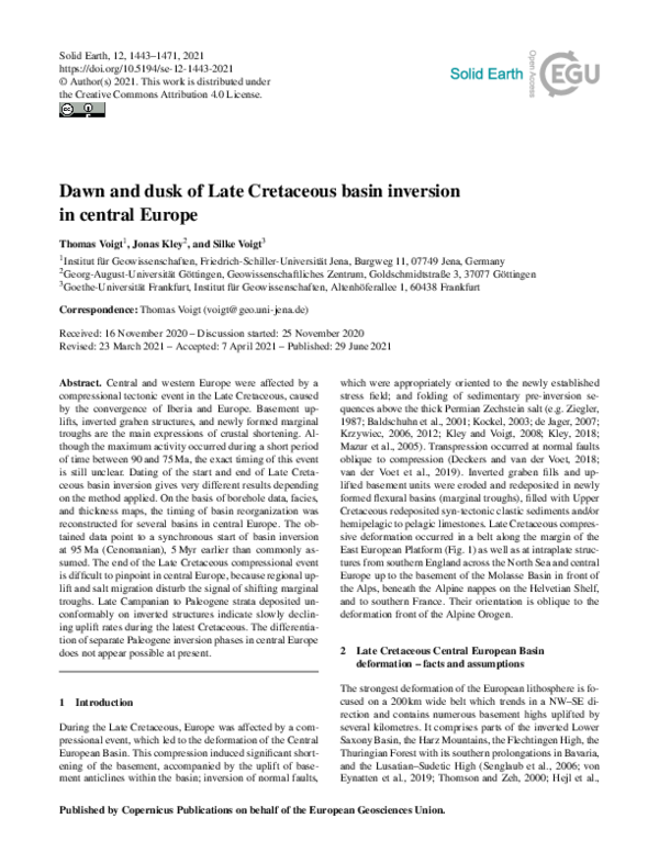
 Thomas Voigt