


MODULE-3 EG.pdf
- 2. Structural geology is the study of the three-dimensional distribution of rock units with respect to their deformational histories. The primary goal of structural geology is to use measurements of present-day rock geometries to uncover information about the history of deformation (strain) in the rocks, and ultimately, to understand the stress field that resulted in the observed strain and geometries. Prepared by- Prof. Basweshwar S. J.
- 3. The study of geologic structures has been of prime importance in economic geology, petroleum geology mining geology. • Folded and faulted rock strata commonly form traps that accumulate and concentrate fluids such as petroleum and natural gas. • Similarly, faulted and structurally complex areas are notable as permeable zones for hydrothermal fluids, resulting in concentrated areas of base and precious metal ore deposits. • Veins of minerals containing various metals commonly occupy faults and fractures in structurally complex areas. • These structurally fractured and faulted zones often occur in association with intrusive igneous rocks. • Deposits of gold, silver, copper, lead, zinc, and other metals, are commonly located in structurally complex areas USE AND IMPORTANCE- Prepared by- Prof. Basweshwar S. J.
- 4. Outcrop • An outcrop or rocky outcrop is a visible exposure of bedrock or ancient artificial deposits on the surface of the Earth. Features- Outcrops do not cover the majority of the Earth's land surface because in most places the bedrocks are covered by a mantle of soil and vegetation and cannot be seen or examined closely. However, in places where the overlying cover is removed through erosion or tectonic uplift, the rock may be exposed, or crop out. Such exposure will happen most frequently in areas where erosion is rapid and exceeds the weathering rate such as on steep hillsides, mountain ridges and tops, river banks, and tectonically active areas. Prepared by- Prof. Basweshwar S. J.
- 5. • Most of the time, data collection occurs in the field. • Geologists record information from a series of different outcrops. • An outcrop is simply a rock column exposed at the surface, • Naturally (because of erosion or mountain building) or • Artificially (because for instance of a road cut, a tunnel, or an excavation). Prepared by- Prof. Basweshwar S. J.
- 6. Prepared by- Prof. Basweshwar S. J.
- 7. Strike and Dip • Strike and dip refer to the orientation or attitude of a geologic feature. • Planes can be defined in space by their inclination or dip and their strike, the bearing of the line of intersection of the plane and a horizontal surface. • The bearing of the projection of the dip on a horizontal surface is in a direction at right angles to the strike. This is called the dip direction. • Strike and dip, also known as the attitude of a surface, are mainly used during the geological mapping of an area. Prepared by- Prof. Basweshwar S. J.
- 8. • When a Rock layer is tilted, it could be tilted in any direction. • That intersection is the strike. • This line (the strike) would make a unique angle with respect to the (geographic) North. • This angle can be measured in the field with a compass, making it possible to plot the strike and its orientation relative to the North on a map. • The strike is represented by the long arm of the T in the T-symbol, and its angle to the North is simply visible on a map because we are drawing it on the map at that angle (remember that all maps have North at the top). Prepared by- Prof. Basweshwar S. J.
- 9. • The dip is simply the angle of maximum inclination of the strike layer. • In the figure, we can see the strike, represented by the black line (line of strike) marking the intersection of the tilted layer and the horizontal surface, here represented by a body of water for simplicity. • We can also see the dip, which is the angle (i.e. 30 degrees) of tilt with respect to the horizontal surface, and which points to the left (direction of dip). Prepared by- Prof. Basweshwar S. J.
- 10. Prepared by- Prof. Basweshwar S. J.
- 11. Unconformities • Unconformities are gaps in the geologic record that may indicate incidents of crustal deformation, erosion, and sea level variations. • They are a feature of stratified rocks, and are therefore usually found in sediments. • They are surfaces between two rock bodies that constitute a substantial break in the geologic record. • Unconformities represent times when deposition stopped, an interval of erosion removed some of the previously deposited rock, and finally deposition was resumed. Prepared by- Prof. Basweshwar S. J.
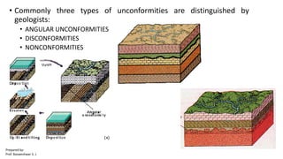
- 12. • Commonly three types of unconformities are distinguished by geologists: • ANGULAR UNCONFORMITIES • DISCONFORMITIES • NONCONFORMITIES Prepared by- Prof. Basweshwar S. J.
- 13. • Angular Unconformities are those where an older package of sediments has been tilted, reduced by erosion, and than a younger package of sediments was deposited on this erosion surface. • Stages- • First- Settling and sediment deposition occurs; • Second- Rocks are Uplifted and tilted (deformation) • Third- Erosion removes the uplifted mountain range. • Fourth- Subsiding occurs, the sea covers the land surface, and new sediments deposition. Prepared by- Prof. Basweshwar S. J.
- 14. • Disconformities are also an erosion surface between two packages of sediment, but the lower package of sediments was not tilted prior to deposition of the upper sediment package. • Stages- • First- Setting and Sediment Deposition. • Second: uplift and erosion; • Third: Renewed subsidence and d eposition. Prepared by- Prof. Basweshwar S. J.
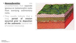
- 15. • Nonconformities are unconformities that separate igneous or metamorphic rocks from overlying sedimentary rocks. • They usually indicate that a long period of erosion occurred prior to deposition of the sediments (several km of erosion necessary). Prepared by- Prof. Basweshwar S. J.
- 16. Inliers • An inlier is an area of older rocks surrounded by younger rocks. • Inliers are typically formed by the erosion of overlying younger rocks to make known limited exposure of the older underlying rocks. • Faulting or folding may also contribute to the observed outcrop pattern. Prepared by- Prof. Basweshwar S. J.
- 17. Outliers • An outlier is an area of younger rock completely surrounded by older rocks. • An outlier is typically formed when sufficient erosion of surrounding rocks has taken place to sever the younger rock's original continuity with a larger mass of the same younger rocks nearby. Prepared by- Prof. Basweshwar S. J.
- 18. Overlap • Overlap is the geologic phenomenon of successively wedge-shaped younger rock strata extending progressively further across an erosion surface cut in older rocks. • It is generally associated with a marine misbehavior. • It is a more general term than Onlap, in which the younger beds overlap onto successively older beds. The opposite is offlap. Prepared by- Prof. Basweshwar S. J.
- 19. Faults and Folds • A geological fold occurs when one or a stack of originally flat and planar surfaces, such as sedimentary strata, are bent or curved as a result of permanent deformation. • Sedimentary folds are those due to collapsing of sedimentary material before it is solidifies. • Folds in rocks vary in size from microscopic waves to mountain-sized folds. Prepared by- Prof. Basweshwar S. J.
- 20. Faults • A fault is a crack in the Earth's crust. • Typically, faults are associated with the boundaries between Earth's tectonic plates. • In an active fault, the pieces of the Earth's crust along a fault move over time. • The moving rocks can cause earthquakes. Prepared by- Prof. Basweshwar S. J.
- 21. CE SIGNIFICANCE • Faults may pose problems of settlement, sliding, seepage and seismicity and also landslides. • Treatment depends on the type, nature and location of fault and type of the civil engineering structures. • Treatment include concrete plug, reinforced concrete plug, mat, grouting etc. Prepared by- Prof. Basweshwar S. J.
- 22. • Joints can not be grouted closed or cemented over, especially if building a embankment or a dam. • Mainly because it is so difficult to map the full extent of the joints. • Folds can cause variation in the depth and hardness of solid rock. • Unconformity's, a beak in the uniformity of the soil or rock thus affecting the safe placement of support structures and thus the future stability of the building. • A civil engineer would want to know the depth to basement rock, the location of active faults within the project's footprint, and differences in composition, or attitude of rock basement, inherent weaknesses associated with joints, etc. • The nature of the foundation beneath a civil structure could have an important bearing on the way it should be designed, or even its placement. Prepared by- Prof. Basweshwar S. J.