Casos de uso do FME no IBGE
•
0 likes•246 views

The document summarizes two cases of using FME at the Brazilian Institute of Geography and Statistics (IBGE). Case 1 describes how FME was used to develop a process for automatically generating topographic maps from vector data. Case 2 discusses how FME was used to: 1) create a geoid undulation model from IBGE data, 2) calculate geoid heights and convert ellipsoid heights to orthometric heights for over 16 million points, and 3) develop processes to analyze and compare digital elevation models using different vertical datums. The document indicates FME helped address challenges like processing large datasets more efficiently.
Report
Share


Casos de uso do FME no IBGE
- 1. Encontro de Usuários 2018
- 2. Casos de uso do FME no IBGE Renan de Alcantara Soares Ludolf da Mota Silva renan.soares@ibge.gov.br ludolf.silva@ibge.gov.br
- 3. The Brazilian Institute of Geography and Statistics (IBGE) is the main provider of data and information in Brazil, which responds to the needs of the most diverse segments of civil society, as well as federal, state and municipal government bodies. IBGE offers a complete and current view of the Country through the performance of its main functions: Production and analysis of statistical information Coordination and consolidation of statistical information Production and analysis of geographical information Coordination and consolidation of geographical information Documentation and dissemination of information Coordination of statistical and cartographic systems
- 4. Coordenação de Cartografia Coordination of Cartography The Coordination of Cartography is responsible for planning, organizing, coordinating, supervising and executing the cartographic works, aiming at the production of maps, as well as other documents of a cartographic nature, necessary for the representation of the Brazilian territorial space "(Portaria nº 215, 12/08/2004 - Art. 60.) " Interoperability of data from many sources
- 5. Resumo da apresentação de 2017 Summary of the 2017 presentation CCAR Vetorial cartographic base production of all national territory 1:1.000.000 1:250.000 1:100.000 (in progress) 1:25.000 (RJ) (Coordination of Cartography main use) EDGV (Structure of Vector Geospatial Data) Standarize Topological Rules Identify Fix
- 6. Equipe Team Renan de Alcantara Soares Cartographic and Surveyor Engineer - Federal University of Viçosa (UFV) Rafael Damiati Ferreira Geographer – São Paulo State University (UNESP) Master in Remote Sensing – Brazilian National Institute for Space Research (INPE) Ludolf da Mota Silva Cartographic Engineer - Rio de Janeiro State University (UERJ) All with advanced knowledge in GIS, but had never used FME before, learning it by job needs and investigative curiosity.
- 7. Casos Cases #1 The IBGE provides topographic maps that constitute the reference bases on which the spatialisation of different thematic information and the knowledge of the territory for the planning of actions of the public and private sector are operationalized. Topographic maps are available for printing with standard cartographic symbols and conventions, coordinate grid and marginal information. However, some of these maps may be considered outdated due to their year of production, which was still used in analytical cartography.
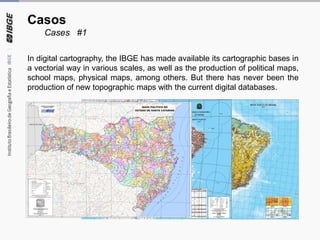
- 8. Casos Cases #1 In digital cartography, the IBGE has made available its cartographic bases in a vectorial way in various scales, as well as the production of political maps, school maps, physical maps, among others. But there has never been the production of new topographic maps with the current digital databases.
- 9. Casos Cases #1 But during some research at the FME, testing some of the transformers, we found the transformer 'MapnikRasterizer' and started some tests, which grew and became a prototype. +
- 10. Casos Cases #1 And nowadays we have the well- developed main stream, which calls within it another 14 tabs (green boxes), each one arranging different areas of a topographic map so that everyone enters the ‘MapnikRasterizer’ and leaves a PDF/Tiff from the selected region (By MI or free selection)
- 11. Casos Cases #1 Some of these green boxes contain easy streams, some not so many, some are complicated, and even larger than the main stream.
- 12. Casos Cases #1 – RESULTS ~ Map made in 40s
- 13. Casos Case #2 Geoid height calculations and altitude comparison
- 14. Casos Case #2 – Geoid height calculations and altitude comparison Geoid height is the distance of the geoid relative to the reference ellipsoid. The geoidal height in the Brazilian territory is provided by the IBGE through a geoid undulation model, made from gravimetric surveys. This model is used to perform conversions between geometric altitude (ellipsoid) and orthometric altitude (geoid), according to the figure below. INTRODUCTION
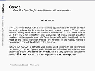
- 15. Casos Case #2 – Geoid height calculations and altitude comparison MOTIVATION INCRA* provided IBGE with a file containing approximately 16 million points in the entire national territory coming the rural property registry. These points contain, among other attributes, values of coordinates X, Y, Z, which can be used by IBGE for validation and evaluation of many digital elevation models, but these points have only Z coordinates referred to the ellipsoid, while most of the digital elevation models are referred to the Geoid, making it necessary to convert the altitude of the this points. IBGE's MAPGEO2015 software was initially used to perform this conversion, but the large number of points made the process unfeasible, since the software processes around 200 points per minute, so in a very optimistic perspective, about 1400 hours would be spent to process the 16 million points. *Instituto Nacional de Colonização e Reforma Agrária
- 16. Casos Case #2 – Geoid height calculations and altitude comparison SOLUTION – Part I Use the FME to create a geoid undulation model in .tif format from the geoid height grid in .txt format developed by IBGE and used in MAPGEO2015 software. LONG LAT N
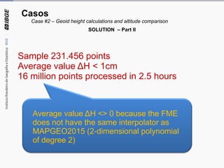
- 17. Casos Case #2 – Geoid height calculations and altitude comparison Develop a flow in the FME to extract the values of the geoid height according to their coordinates and using the appropriate interpolations, then compare with the results obtained by MAPGEO2015 in a sample of 231 thousand points approximately. N=15 N=13N=18 N=19 N=17 N=16 N=14 N=20 N=16 h=63,8H=h-N SOLUTION – Part II
- 18. Sample 231.456 points Average value ΔH < 1cm 16 million points processed in 2.5 hours Average value ΔH <> 0 because the FME does not have the same interpolator as MAPGEO2015 (2-dimensional polynomial of degree 2) Casos Case #2 – Geoid height calculations and altitude comparison SOLUTION – Part II
- 19. Develop a flow in the FME to measure the quality of Digital Elevation Models in a standardized way already using the corrected altitudes. Nº Max Aver Std D. Min Pec 23 3.67 1.77 6.81 1.47 6.63 Casos Case #2 – Geoid height calculations and altitude comparison SOLUTION – Part III
- 20. It was also possible to develop a flow in the FME that converts geometric and orthometric altitudes of MDEs in the Raster format, not only for points, allowing MDEs with different altitudes types to be compared to each other. GoogleGoogle and level curvesDifference between MDE1(h) and MDE2(H transformed to h) Casos Case #2 – Geoid height calculations and altitude comparison SOLUTION – Part IV