Location via proxy:   [ UP ]  
[Report a bug]   [Manage cookies]                
SlideShare a Scribd company logo
Ziaul Haque
 an elongate region of potential sediment accommodation that
forms on continental crust between a contractional orogenic
belt and the adjacent craton.
 related to subduction and the resulting peripheral or retroarc
fold-thrust belt.
 the longitudinal dimension of the foreland basin system is
roughly equal to the length of the fold-thrust belt
Fig: (A) Schematic map
view of a ‘typical’ foreland basin,
bounded longitudinally by a pair
of marginal ocean basins.
(B) The generally accepted notion
of foreland-basin geometry in
transverse crosssection.
scale is not specified
The first recognition of the variety of foreland basin types was by
Dickinson (1974) who distinguished retroarc from peripheral foreland
basin.
Mountain belts associated with the convergent plate boundary are
flanked on either side by two peripheral foreland basins, one over the
under thrust plate which is called pro-foreland/peripheral basin and
one over the over-riding plate which is called retro foreland basin
(Naylar & Sinclair, 2008).
Fig : The pro-foreland basin lies in the flexural depression over the subducting
slab which advances towards orogen at the regional convergence rate and
retro-foreland basin lies in the flexural depression above the overriding slab
which predominantly stationary to the orogeny.
Fig: (A) Schematic diagram showing
the principal loads in peripheral
foreland basin systems on the
subducting plate.
(B) Retroarc foreland basin systems
on the overriding plate.
 Forms on the overriding plate
 Form by flexure of lithosphere
• Ex- Andes and Rocky mountain foreland basin
 Form at collision zones on the continental crust of the subducting plate.
It can be:
1. Arc-arc collision
• Form small peripheral basins
• Ex-Honshu arc in Japan
2. Arc-continent collison
• Form more significant peripheral basins
• Ex- Luzon arc and mainland China
3. Continent-continent collision
• Largest peripheral basin
• Ex- Himalayan foreland basin
 Compressional tectonics behind the arc-trench system is the driving
force for subsidence of foreland basin (Ingersoll, 1988).
 Jordan (1981) worked an asymmetric Cretaceous foreland basin
associated with the Idaho-Wyoming thrust belt and demonstrated
how thrust loading and sedimentary loading resulted in broad flexure
in lithosphere and generate accommodation space for orogenic
sediments.
Fig : Subsidence of foredeep with increase of the loads due to the
orogenic thrust movement as well as sediment accumulation
Fig : Far field subsidence due to viscous coupling of subducting slab and
mantle wedge.
Three structural components
● Orogenic Wedge
• Upthrown portion of thrust belt creating overlying wedge
● Flexural subsidence
• result of sediment filling and dynamic loading from thrust activity
● Flexural Bulge
• uplift due to loading and compressional stresses:
Fig : Three structural components of a Foreland Basin.
Four depozones:
1. Wedge top
2. Foredeep
3. Fore bulge
4. Back bulge
 Wedge Top
• deposited on top of the frontal part of the orogenic wedges,
including ‘piggyback’ and ‘thrust top’ basins.
• synorogenic sediments and coarsest deposits in the basin fill.
• sediments is characterized by extreme coarseness, angular,
numerous tectonic unconformities
 Foredeep
• deposited between the structural front of the thurst belt and the
proximal flank of the forebulge.
• thickest depozones and typically 100-300 km wide and 2-8 km
thick
• consists of fluvial, deltaic and marine sediments
 Fore bulge
• potential flexural uplift between the foredeep and back-bulge
depozones.
• most broad region.
• thinnest sedimentary accumulation.
 Back bulge
• broad and shallow region of potential flexural subsidence
cratonward of the forebulge.
• depositional environment of this region is generally shallow marine
to terrestrial.
• sediments of this area is very fine and often carbonate platform is
developed.
Tectonics and Sedimentation of Foreland Basin
Fig: Isopach map of the retroarc Sevier
fold-thrust belt in the western interior
foreland basin of the United States.
Solid circles represent surface sections
from Currie (1994) and Craig
(1955);open circles represent well data
from Currie (1994), Craig (1955) and
Sprinkel (1994).
Fig: an active peripheral
foreland basin system in
northern Italy.
(after Pieri, in Bally,
1983).
Fig: Isopach map of the Taranaki
retroarc basin in New Zealand.
Holt and Stern (1994).
Fig: Perioheral foreland
Basin system along the
South-west side of the Zargos
Collisional orogenic belt.
Kassler (1973).
Examples of foreland basin

More Related Content

Tectonics and Sedimentation of Foreland Basin

  • 2.  an elongate region of potential sediment accommodation that forms on continental crust between a contractional orogenic belt and the adjacent craton.  related to subduction and the resulting peripheral or retroarc fold-thrust belt.  the longitudinal dimension of the foreland basin system is roughly equal to the length of the fold-thrust belt
  • 3. Fig: (A) Schematic map view of a ‘typical’ foreland basin, bounded longitudinally by a pair of marginal ocean basins. (B) The generally accepted notion of foreland-basin geometry in transverse crosssection. scale is not specified
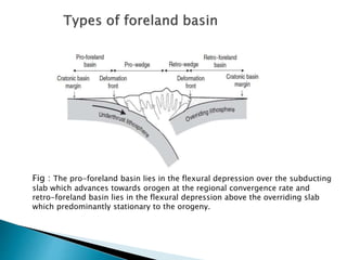
  • 4. The first recognition of the variety of foreland basin types was by Dickinson (1974) who distinguished retroarc from peripheral foreland basin. Mountain belts associated with the convergent plate boundary are flanked on either side by two peripheral foreland basins, one over the under thrust plate which is called pro-foreland/peripheral basin and one over the over-riding plate which is called retro foreland basin (Naylar & Sinclair, 2008).
  • 5. Fig : The pro-foreland basin lies in the flexural depression over the subducting slab which advances towards orogen at the regional convergence rate and retro-foreland basin lies in the flexural depression above the overriding slab which predominantly stationary to the orogeny.
  • 6. Fig: (A) Schematic diagram showing the principal loads in peripheral foreland basin systems on the subducting plate. (B) Retroarc foreland basin systems on the overriding plate.
  • 7.  Forms on the overriding plate  Form by flexure of lithosphere • Ex- Andes and Rocky mountain foreland basin  Form at collision zones on the continental crust of the subducting plate. It can be: 1. Arc-arc collision • Form small peripheral basins • Ex-Honshu arc in Japan
  • 8. 2. Arc-continent collison • Form more significant peripheral basins • Ex- Luzon arc and mainland China 3. Continent-continent collision • Largest peripheral basin • Ex- Himalayan foreland basin
  • 9.  Compressional tectonics behind the arc-trench system is the driving force for subsidence of foreland basin (Ingersoll, 1988).  Jordan (1981) worked an asymmetric Cretaceous foreland basin associated with the Idaho-Wyoming thrust belt and demonstrated how thrust loading and sedimentary loading resulted in broad flexure in lithosphere and generate accommodation space for orogenic sediments.
  • 10. Fig : Subsidence of foredeep with increase of the loads due to the orogenic thrust movement as well as sediment accumulation
  • 11. Fig : Far field subsidence due to viscous coupling of subducting slab and mantle wedge.
  • 12. Three structural components ● Orogenic Wedge • Upthrown portion of thrust belt creating overlying wedge ● Flexural subsidence • result of sediment filling and dynamic loading from thrust activity ● Flexural Bulge • uplift due to loading and compressional stresses: Fig : Three structural components of a Foreland Basin.
  • 13. Four depozones: 1. Wedge top 2. Foredeep 3. Fore bulge 4. Back bulge
  • 14.  Wedge Top • deposited on top of the frontal part of the orogenic wedges, including ‘piggyback’ and ‘thrust top’ basins. • synorogenic sediments and coarsest deposits in the basin fill. • sediments is characterized by extreme coarseness, angular, numerous tectonic unconformities  Foredeep • deposited between the structural front of the thurst belt and the proximal flank of the forebulge. • thickest depozones and typically 100-300 km wide and 2-8 km thick • consists of fluvial, deltaic and marine sediments
  • 15.  Fore bulge • potential flexural uplift between the foredeep and back-bulge depozones. • most broad region. • thinnest sedimentary accumulation.  Back bulge • broad and shallow region of potential flexural subsidence cratonward of the forebulge. • depositional environment of this region is generally shallow marine to terrestrial. • sediments of this area is very fine and often carbonate platform is developed.
  • 17. Fig: Isopach map of the retroarc Sevier fold-thrust belt in the western interior foreland basin of the United States. Solid circles represent surface sections from Currie (1994) and Craig (1955);open circles represent well data from Currie (1994), Craig (1955) and Sprinkel (1994).
  • 18. Fig: an active peripheral foreland basin system in northern Italy. (after Pieri, in Bally, 1983).
  • 19. Fig: Isopach map of the Taranaki retroarc basin in New Zealand. Holt and Stern (1994).
  • 20. Fig: Perioheral foreland Basin system along the South-west side of the Zargos Collisional orogenic belt. Kassler (1973). Examples of foreland basin