Location via proxy:   [ UP ]  
[Report a bug]   [Manage cookies]                
SlideShare a Scribd company logo
3. The Iberian Peninsula in
the Ancient Period
2nd
ESO
Maira Gil Camarón
3. The Iberian Peninsula in the Ancient Period
Indo-European invasions
The Indo-European crossed over the Pyrinees to the Iberian
Peninsula from the great plains of Europe between the 10th
and
5th
centuries BC in different surges. They were very different
from each other but had similar linguistic roots
In the blank map draw an arrow to indicate the area of
origin of the Indo-European peoples. Then, shade the area
in which they settled
Colonisers
Different colonisers also arrived at the Iberian Peninsula
from Phoenicia, Greece and Carthage, and founded colonies
on the coast to control the metal trade
In the blank map locate and label the area of origin of the
Phoenicians, Greeks and Carthaginians
Phoenicians
They came from Phoenicia (today, Lebanon) and arrived in about the 10th
century BC.
They never went inland: they had no interest in conquering, only in trading
They traded with the natives by bartering. They exchanged manufactured
products for metals.
They taught the indigenous peoples how to grow vines, salt fish to conserve it,
use the potter’s wheel, create purple fabric dyes from sea snails and use
alphabetic writing.
Their main trading posts were Gadir, Malaka, Sexi and Abdera
3. The Iberian Peninsula in the Ancient Period
Greeks
They came from different Greek poleis. They reached the peninsula between
the 8th
- 6th
centuries BC and settled along the Mediterranean coast.
They were mainly interested in trading
They used these colonies to trade with the peninsula’s indigenous peoples
and contributed some elements from their culture: money, writing, the
cultivation of olive trees, arts...
Emporion, Rhode, Mainake were some of their colonies.
Carthaginians
They came from Carthage, a Phoenician colony founded in
North Africa. In the 7th
century BC they settled in the Balearic
Islands. When the Persians conquered Phoenicia in the 6th
century BC, Carthage took control over the Phoenicians
colonies in the Iberian Peninsula
Frequent confrontations with the Greeks, so the
Mediterranean was divided into two commercial areas:
South  Carthaginians
North  Greeks
Main colonnies: Ebussus and Qart Hadasht
In the blank map, locate and label the main Phoenician, Greek and
Carthanigian colonies in the Iberian Peninsula
Tartessos
The kingdom of Tartessos is
the first organized state in
the history of the Iberian
Peninsula
Splendour: 8th
- 6th
centuries
BC, due to trade with
Phoenicians and Greeks
End: around 500 BC,
possibly as a result of
Carthaginian domination
Location: uncertain area
between Huelva and the
lower and middle valley of
the Guadalquivir River
Political organization: monarchy  Argantonio
Economy: based on agriculture, livestock farming and
the exploitation of the plentiful metals to be found in
the region
They had a knowledge of writing and developed a very
refined form of art
Pre-Roman Peoples
The influence of the colonisers in the Mediterranean coast and the
Indo-European in the North West, divided the inhabitants of the
Iberian Peninsula into two different groups: Iberians and Celts, the
population of the Peninsula when the Roman conquest started
3. The Iberian Peninsula in the Ancient Period
Iberians
They were located in the Mediterranean coast between the 6th and
1st centuries BC and lived in fortified towns
Iberian economy was based on five sectors:
Agriculture. They grew wheat, vine and olive
Livestock farming. They mostly bred sheep and cows
Mining. It was a major sector based on gold and silver
Crafts. They made iron works (swords), pottery and textiles
Trade. They traded either with Phoenician or with Greek colonies
Iberians minted their own currency and had a writing system due to
Greek influences
They had a polytheistic religion with female goddesses. They
incinerated their dead
Their art was influenced by the Greeks and major examples are the
damas such as the Dama de Elche or Dama de Baza
3. The Iberian Peninsula in the Ancient Period
Celts
They were Indo-Europeans and cohabitated with native peoples
like Cantabri and Vascones. They lived in castros, which were
walled and high hamlets whose houses were circular and thatch-
roofed
Celtic economy was based on several sectors depending on the
area:
Sheepherding (northwest)
Agriculture of cereals (centre and west)
Hunting
Iron and Bronze work
Celts lived in tribes and very few families owned the lands
They did not have either currency or writing system
They had a polytheistic religion that worshipped stars and natural
elements or animals. They incinerated their dead
3. The Iberian Peninsula in the Ancient Period
Complete the chart
IBERIANS CELTS
LOCATION AND
INFLUENCE
VILLAGES AND HOUSES
POLITICAL
ORGANISATION
ECONOMY
RELIGION
CULTURE AND ART
Roman Hispania
The Roman conquest of Hispania
First phase 218-201 BC. Wars against the Carthaginians and
their native allies (Iberians) to gain control of the Mediterranean
coast
1st
Punic War
Carthage vs Rome. They wanted to control the western
Mediterranean (Sicily, Corsica and Sardinia). Rome won
2nd
Punic War
Afraid of the expansion of the Carthaginians in the Iberian
Peninsula, Rome became an ally of Sagunto, a city to the south
of the Ebro river, a place where the Carthaginians couldn’t go.
Hannibal attacked it and the Romans declared the war to
Carthage. Scipio arrived at Emporion to fight Hannibal and
therefore the conquest of the Iberian Peninsula began, despite it
wasn’t their initial intention
3. The Iberian Peninsula in the Ancient Period
Second phase 201-154 BC. The conquest of the Iberian
Mountains, where the Romans met with little opposition
from the Iberians, and the eastern plateau
Third phase 154-133 BC. Wars against peoples of the western
zone, who offered more resistance. The fiercest fighting was
against the Arevaci (Numantia), the Vaccei and the
Lusitanians (Viriato)
Fouth phase 29-19 BC. The conquest was complete when the
Romans subjugated the warlike tribes of the Gallaecians,
Cantabrians and Asturians
3. The Iberian Peninsula in the Ancient Period
The city of Numantia resisted Roman attacks for twenty years, but in
133 BC, after a 15-month siege by 60000 troops, the city surrendered.
Almost all the city’s 25000 defenders died in the fighting or from
huger. Many committed suicide rather than become roman slaves.
The capture of Numantia allowed the Romans to control the rest of
the plateau.
Explain the 1st and 2nd
Punic Wars
Explain in detail and with your own words the Roman
conquest of the Iberian Peninsula (in a .doc document in
Classroom)
How the territory was organised
Romans divided the territory
into provinces:
In the republican period, there
were two: Hispania Citerior,
whose capital was Tarraco, and
Hispania Ulterior, whose
capital was Corduba
In the 1st
century AD, Augustus
established three provinces:
Tarraconensis, Baetica and
Lusitania
In the 4th
century AD, Hispania
was divided into five mainland
provinces plus Balearica
Each province had a governor,
who controlled the territory and
collected taxes
Draw the map of the provinces in Hispania during the
Empire. Include on it the capital city of each province
Romanization of Hispania
Roman culture: religion, language (latin)
Roman cities  Romans planned complete cities
including the layout, walls and all public works. Roman
cities had buildings that were religious (temples),
political (basilica, curia, forum), commemorative
(arches) and for leisure (baths, theatre, amphitheatre,
circus). They also had running water (aqueducts) and
sewers
3. The Iberian Peninsula in the Ancient Period

More Related Content

3. The Iberian Peninsula in the Ancient Period

  • 1. 3. The Iberian Peninsula in the Ancient Period 2nd ESO Maira Gil Camarón
  • 3. Indo-European invasions The Indo-European crossed over the Pyrinees to the Iberian Peninsula from the great plains of Europe between the 10th and 5th centuries BC in different surges. They were very different from each other but had similar linguistic roots
  • 4. In the blank map draw an arrow to indicate the area of origin of the Indo-European peoples. Then, shade the area in which they settled
  • 5. Colonisers Different colonisers also arrived at the Iberian Peninsula from Phoenicia, Greece and Carthage, and founded colonies on the coast to control the metal trade
  • 6. In the blank map locate and label the area of origin of the Phoenicians, Greeks and Carthaginians
  • 7. Phoenicians They came from Phoenicia (today, Lebanon) and arrived in about the 10th century BC. They never went inland: they had no interest in conquering, only in trading They traded with the natives by bartering. They exchanged manufactured products for metals. They taught the indigenous peoples how to grow vines, salt fish to conserve it, use the potter’s wheel, create purple fabric dyes from sea snails and use alphabetic writing. Their main trading posts were Gadir, Malaka, Sexi and Abdera
  • 9. Greeks They came from different Greek poleis. They reached the peninsula between the 8th - 6th centuries BC and settled along the Mediterranean coast. They were mainly interested in trading They used these colonies to trade with the peninsula’s indigenous peoples and contributed some elements from their culture: money, writing, the cultivation of olive trees, arts... Emporion, Rhode, Mainake were some of their colonies.
  • 10. Carthaginians They came from Carthage, a Phoenician colony founded in North Africa. In the 7th century BC they settled in the Balearic Islands. When the Persians conquered Phoenicia in the 6th century BC, Carthage took control over the Phoenicians colonies in the Iberian Peninsula Frequent confrontations with the Greeks, so the Mediterranean was divided into two commercial areas: South  Carthaginians North  Greeks Main colonnies: Ebussus and Qart Hadasht
  • 11. In the blank map, locate and label the main Phoenician, Greek and Carthanigian colonies in the Iberian Peninsula
  • 12. Tartessos The kingdom of Tartessos is the first organized state in the history of the Iberian Peninsula Splendour: 8th - 6th centuries BC, due to trade with Phoenicians and Greeks End: around 500 BC, possibly as a result of Carthaginian domination Location: uncertain area between Huelva and the lower and middle valley of the Guadalquivir River
  • 13. Political organization: monarchy  Argantonio Economy: based on agriculture, livestock farming and the exploitation of the plentiful metals to be found in the region They had a knowledge of writing and developed a very refined form of art
  • 14. Pre-Roman Peoples The influence of the colonisers in the Mediterranean coast and the Indo-European in the North West, divided the inhabitants of the Iberian Peninsula into two different groups: Iberians and Celts, the population of the Peninsula when the Roman conquest started
  • 16. Iberians They were located in the Mediterranean coast between the 6th and 1st centuries BC and lived in fortified towns Iberian economy was based on five sectors: Agriculture. They grew wheat, vine and olive Livestock farming. They mostly bred sheep and cows Mining. It was a major sector based on gold and silver Crafts. They made iron works (swords), pottery and textiles Trade. They traded either with Phoenician or with Greek colonies Iberians minted their own currency and had a writing system due to Greek influences They had a polytheistic religion with female goddesses. They incinerated their dead Their art was influenced by the Greeks and major examples are the damas such as the Dama de Elche or Dama de Baza
  • 19. Celts They were Indo-Europeans and cohabitated with native peoples like Cantabri and Vascones. They lived in castros, which were walled and high hamlets whose houses were circular and thatch- roofed Celtic economy was based on several sectors depending on the area: Sheepherding (northwest) Agriculture of cereals (centre and west) Hunting Iron and Bronze work Celts lived in tribes and very few families owned the lands They did not have either currency or writing system They had a polytheistic religion that worshipped stars and natural elements or animals. They incinerated their dead
  • 21. Complete the chart IBERIANS CELTS LOCATION AND INFLUENCE VILLAGES AND HOUSES POLITICAL ORGANISATION ECONOMY RELIGION CULTURE AND ART
  • 22. Roman Hispania The Roman conquest of Hispania First phase 218-201 BC. Wars against the Carthaginians and their native allies (Iberians) to gain control of the Mediterranean coast 1st Punic War Carthage vs Rome. They wanted to control the western Mediterranean (Sicily, Corsica and Sardinia). Rome won 2nd Punic War Afraid of the expansion of the Carthaginians in the Iberian Peninsula, Rome became an ally of Sagunto, a city to the south of the Ebro river, a place where the Carthaginians couldn’t go. Hannibal attacked it and the Romans declared the war to Carthage. Scipio arrived at Emporion to fight Hannibal and therefore the conquest of the Iberian Peninsula began, despite it wasn’t their initial intention
  • 24. Second phase 201-154 BC. The conquest of the Iberian Mountains, where the Romans met with little opposition from the Iberians, and the eastern plateau Third phase 154-133 BC. Wars against peoples of the western zone, who offered more resistance. The fiercest fighting was against the Arevaci (Numantia), the Vaccei and the Lusitanians (Viriato) Fouth phase 29-19 BC. The conquest was complete when the Romans subjugated the warlike tribes of the Gallaecians, Cantabrians and Asturians
  • 26. The city of Numantia resisted Roman attacks for twenty years, but in 133 BC, after a 15-month siege by 60000 troops, the city surrendered. Almost all the city’s 25000 defenders died in the fighting or from huger. Many committed suicide rather than become roman slaves. The capture of Numantia allowed the Romans to control the rest of the plateau.
  • 27. Explain the 1st and 2nd Punic Wars Explain in detail and with your own words the Roman conquest of the Iberian Peninsula (in a .doc document in Classroom)
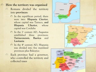
  • 28. How the territory was organised Romans divided the territory into provinces: In the republican period, there were two: Hispania Citerior, whose capital was Tarraco, and Hispania Ulterior, whose capital was Corduba In the 1st century AD, Augustus established three provinces: Tarraconensis, Baetica and Lusitania In the 4th century AD, Hispania was divided into five mainland provinces plus Balearica Each province had a governor, who controlled the territory and collected taxes
  • 29. Draw the map of the provinces in Hispania during the Empire. Include on it the capital city of each province
  • 30. Romanization of Hispania Roman culture: religion, language (latin) Roman cities  Romans planned complete cities including the layout, walls and all public works. Roman cities had buildings that were religious (temples), political (basilica, curia, forum), commemorative (arches) and for leisure (baths, theatre, amphitheatre, circus). They also had running water (aqueducts) and sewers