5 rock properties
•Download as PPTX, PDF•
11 likes•6,344 views

The document discusses the physical properties of rocks and soils that are important for civil engineering projects. It describes measuring properties like unit weight, density, porosity, strength, and permeability. It then discusses specific gravity determination and how porosity is measured. Various stress types on rocks, including compressive and tensile strength, are defined. Methods for determining rock properties like point load index and Schmidt hammer rebound number are presented. The document also covers rock mass classification systems and significance of faults and folds for engineering projects, as well as weathering and alteration of rocks.
Report
Share


5 rock properties
- 1. ENGINEERING PROPERTIES OF ROCKS AND SOILS
- 2. PHYSICAL PROPERTIES OF ROCKS AND SOILS (INDEX PROPERTIES) For civil engineering design, it is necessary to assign physical properties to each unit of soil or rock within a ground model. These include readily measurable or estimated attributes such as unit weight, density and porosity. Other parameters that are often needed are strength, deformability and permeability. In the case of aggregates (rock used in construction for making concrete) and for armourstone, important attributes are durability and chemical stability. R. R. GADGIL, DEPT. OF EARTH SCIENCE, GOA UNIVERSITY 2
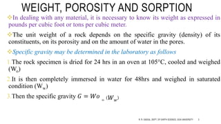
- 3. WEIGHT, POROSITY AND SORPTION In dealing with any material, it is necessary to know its weight as expressed in pounds per cubic foot or tons per cubic meter. The unit weight of a rock depends on the specific gravity (density) of its constituents, on its porosity and on the amount of water in the pores. Specific gravity may be determined in the laboratory as follows 1.The rock specimen is dried for 24 hrs in an oven at 105°C, cooled and weighed (Wo) 2.It is then completely immersed in water for 48hrs and weighed in saturated condition (Ww) 3.Then the specific gravity 𝐺 = 𝑊𝑜 ÷ 𝑊 𝑤 R. R. GADGIL, DEPT. OF EARTH SCIENCE, GOA UNIVERSITY 3
- 4. R. R. GADGIL, DEPT. OF EARTH SCIENCE, GOA UNIVERSITY 4
- 5. WEIGHT, POROSITY AND SORPTION Porosity is a measure of the volume of voids in a material or mass. In materials porosity depends upon the space between grains; in masses it would also include any space provided by open fissures and joints. Intergranular porosity is often determined in the laboratory by comparison between dry and saturated weights of the sample. To become fully saturated, voids must be in contact, and both interconnections and voids must be large enough to allow the flow of water under reasonable pressures. R. R. GADGIL, DEPT. OF EARTH SCIENCE, GOA UNIVERSITY 5
- 6. WEIGHT, POROSITY AND SORPTION One or both of these conditions is often not satisfied, particularly for fine grained materials, and the results of such tests are properly described as apparent porosity. There are some porous rocks, such as vesicular basalts, that are porous but whose porosity cannot be measured by conventional means because the voids are not in contact i.e. the material is impermeable. R. R. GADGIL, DEPT. OF EARTH SCIENCE, GOA UNIVERSITY 6
- 7. MATERIAL V/S MASS Most tests and measurements are made on small-scale samples in the field or the laboratory and need to be scaled up according to theoretical or empirical rules, to include for geological variability, fabric and structure. For example, a soil mass might be made up of a mixture of strong boulders in a matrix of weak, soil-like material, and this mix has to be accounted for in assigning parameters for engineering design. Mass strength, deformability and permeability of rock masses are controlled largely by the fracture network, rather than intact rock properties; the permeability of intact rock might be 10−11 m/sec, which could be thousands of times lower than for the fractured rock mass. R. R. GADGIL, DEPT. OF EARTH SCIENCE, GOA UNIVERSITY 8
- 8. ORIGINS OF PROPERTIES The strength of soil and rock (geomaterials) is derived from friction between individual grains, from cohesion derived from cementation filling pore spaces and from inter-granular bonds such as those formed by pressure solution (Tada & Siever, 1989). The strength and deformability of soil is also a function of the closeness of packing of the mineral grains. Densely packed soil will be forced to dilate (open up) during shear at relatively low confining stresses as the grains override one another and deform, and the work done against dilation provides additional strength. The same principles apply to rough rock joints or fractured rock masses. R. R. GADGIL, DEPT. OF EARTH SCIENCE, GOA UNIVERSITY 9
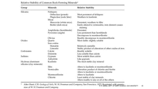
- 9. ORIGINS OF PROPERTIES Different minerals may also have fundamentally different properties – some are more chemically reactive and may form strong chemical bonds in the short term, some are readily crushed or scratched, whilst others are highly resistant to damage or chemical attack. Some, such as talc and chlorite, are decidedly slippery and if present on rock joints can result in instability. R. R. GADGIL, DEPT. OF EARTH SCIENCE, GOA UNIVERSITY 10
- 10. EXAMPLE This picture shows a graded series of sediments. The sand horizons become finer upwards, as is typical of sediments deposited from a river into a lake. At the top of the sample, there is a second sand horizon that has been deposited onto the underlying sediment. This has deformed the underlying sediments, producing a loading structure, which shows that the soil was in a very soft state at the time of formation. R. R. GADGIL, DEPT. OF EARTH SCIENCE, GOA UNIVERSITY 11
- 11. EXAMPLE Contrast this with the rear of the same sample showing conchoidal fractures in what is actually extremely strong rock. The conversion from soft mud to rock has occurred over a long time but has occurred naturally and, in practical geotechnical engineering, we encounter and need to deal with the full range of materials, transitional between these end members. R. R. GADGIL, DEPT. OF EARTH SCIENCE, GOA UNIVERSITY 12
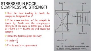
- 12. STRESSES IN ROCK: COMPRESSIVE STRENGTH Generally 3 kinds of stresses are considered in studying the resistivity of the rock: compressive stresses which try to decrease the volume of the material; shear stresses which tend to move one part of the specimen with respect to other or make it flow; and tensile stresses which tend to produce cracks and fissures in the material. Stresses are measures in pounds per square foot or pounds per square inch. Compressive strength of a material such as rock, is the stress required to break a loaded sample that is unconfined at the sides. R. R. GADGIL, DEPT. OF EARTH SCIENCE, GOA UNIVERSITY 13
- 13. Here the load tending to break the sample is designated as P. If the cross section of the sample is 2inch by 2inch and the compressive strength of the rock is 10000 psi, a load of 10000 x 4 = 40,000 lbs will break the sample. Hence the formula goes this way P (psi) = 𝑃 𝐴 P = lbs and A = square inch STRESSES IN ROCK: COMPRESSIVE STRENGTH R. R. GADGIL, DEPT. OF EARTH SCIENCE, GOA UNIVERSITY 14
- 14. STRESSES IN ROCK: COMPRESSIVE STRENGTH R. R. GADGIL, DEPT. OF EARTH SCIENCE, GOA UNIVERSITY 15
- 15. STRESSES IN ROCK: TENSILE STRENGTHThe tensile strength of granite is about 1000 psi, only a fraction of its compressive strength. Other rocks like marble has lower tensile strengths of 700 to 900 psi, limestone about 500 psi and sandstone 100-200 psi. If a stone slab is placed on practically immovable supports and subjected to the action as a load P the slab deflects and there is tension at the bottom of the slab and compression at the top. If the load P is gradually increased, the slab fails by tension. R. R. GADGIL, DEPT. OF EARTH SCIENCE, GOA UNIVERSITY 16
- 16. POINT LOAD INDEX For a point load test, a compressive load is applied through two conical platens, which causes the rock to break in tension between these two points. If the breaking load is P, the point load index, Is, can then be determined by 𝐼 𝑠 = 𝑃 𝐷2 where D is the diameter of the specimen if the load is applied in the diametric direction of a core. In other cases, 𝐷 = 2 𝐴/π, where A is the minimum cross-sectional area of the specimen for a plane through the platen contact points. R. R. GADGIL, DEPT. OF EARTH SCIENCE, GOA UNIVERSITY 17
- 17. POINT LOAD INDEX R. R. GADGIL, DEPT. OF EARTH SCIENCE, GOA UNIVERSITY 18
- 18. POINT LOAD INDEX R. R. GADGIL, DEPT. OF EARTH SCIENCE, GOA UNIVERSITY 19
- 19. SCHMIDT HAMMER REBOUND NUMBER The hammer measures the rebound of a spring-loaded mass impacting against the surface of the sample. The test hammer will hit the concrete at a defined energy. Its rebound is dependent on the hardness of the concrete and is measured by the test equipment. By reference to the conversion chart, the rebound value can be used to determine the compressive strength The Schmidt rebound hammer has been used for testing the quality of concretes and rocks. Schmidt hammers are designed in different levels of impact energy, but the types of L and N are commonly adopted for rock property determinations. The L-type has an impact energy of 0.735 Nm which is only one third that of the N-type. R. R. GADGIL, DEPT. OF EARTH SCIENCE, GOA UNIVERSITY 20
- 20. SCHMIDT HAMMER REBOUND NUMBER R. R. GADGIL, DEPT. OF EARTH SCIENCE, GOA UNIVERSITY 21
- 21. SCHMIDT HAMMER REBOUND NUMBER R. R. GADGIL, DEPT. OF EARTH SCIENCE, GOA UNIVERSITY 22
- 22. ROCK MASS CLASSIFICATION Historically, rock-mass classification has been based on percent core recovery, which is severely limited in value. Core recovery depends on many factors including equipment used, operational techniques, and rock quality, and provides no direct information on hardness, weathering, and defects. Even good core recovery cannot provide information equivalent to that obtained by field examination of large exposures, although ideal situations combine core recovery with exposure examinations. R. R. GADGIL, DEPT. OF EARTH SCIENCE, GOA UNIVERSITY 25
- 23. ROCK MASS CLASSIFICATION R. R. GADGIL, DEPT. OF EARTH SCIENCE, GOA UNIVERSITY 26
- 24. ROCK MASS CLASSIFICATION R. R. GADGIL, DEPT. OF EARTH SCIENCE, GOA UNIVERSITY 27
- 25. ROCK MASS CLASSIFICATION R. R. GADGIL, DEPT. OF EARTH SCIENCE, GOA UNIVERSITY 28
- 26. ROCK MASS CLASSIFICATION R. R. GADGIL, DEPT. OF EARTH SCIENCE, GOA UNIVERSITY 29
- 27. SIGNIFICANCE OF FAULTS AND FOLDS IN ENGINEERING Fractures in rock masses accompanied by differential displacements on both sides of the fracture often cut a site irrespective of the dip and strike of the rock. Search for faults is not always effective, they might be discovered later. Faults may be deeply buried, and if the excavation floor is intercepted by small faults containing gouge and brecciated rock, in many cases it is advisable from both technical and economic viewpoints to abandon the site. In other cases, if a fault is disclosed when the bottom of the excavation has almost reached the design elevation, the site may be made usable by removing a large portion of faulted rock, increasing the cost of both earth and concrete work. R. R. GADGIL, DEPT. OF EARTH SCIENCE, GOA UNIVERSITY 30
- 28. SIGNIFICANCE OF FAULTS AND FOLDS IN ENGINEERING From the basic products of faulting, gouge is probably the most concern in foundation problems. 1. This is usually an impervious material and may hinder or stop the movement of GW and thus create disastrous hydrostatic heads e.g. if encountered in tunnel. 2. Also it may reduce the coefficient of sliding friction along the fault plane; thus any heavy load (e.g. building) placed upon beds overlying a gouge seam may start translating laterally, ultimately causing failure. 3. The presence of soft breccia may cause sudden “squeezes” in a tunnel that intersects a fault. R. R. GADGIL, DEPT. OF EARTH SCIENCE, GOA UNIVERSITY 31
- 29. SIGNIFICANCE OF FAULTS AND FOLDS IN ENGINEERING “active”, “inactive” and “passive” faults need to be identified. Active faults are those in which movements have occurred during the recorded history of man and along which further movements can be expected at any time. Inactive or passive faults are ruptures that have no recorded history of movement and thus are assumed to be and probably will remain in static condition. Unfortunately it is impossible to state definitely if an apparently inactive fault will remain in that condition. The fault may reopen either because of a new strain accumulation in the locality or from the effect of earthquake vibrations. R. R. GADGIL, DEPT. OF EARTH SCIENCE, GOA UNIVERSITY 32
- 30. SIGNIFICANCE OF FAULTS AND FOLDS IN ENGINEERING Of the various types of folds, the synclines are perhaps the most significant in engineering because of their capacity to convey and accumulate fluids. Serious water problems may arise in the construction and maintenance of tunnels intersecting synclines containing water- bearing strata. If such a syncline is discovered before the design period, the elevation of the planned tunnel may be changed inorder to place it in the drier strata. In foundations proper, folds are no so critical as faults. Occassionally, the folds may influence the selection of a damsite. R. R. GADGIL, DEPT. OF EARTH SCIENCE, GOA UNIVERSITY 33
- 31. ALTERATION OF ROCK Various rock types decompose to characteristic soil types. The type of residual soil (active to inactive) and the approximate depth to fresh rock at a given location are generally predictable if the climate, topography, and basic rock type are known and the processes of rock alteration are understood. Alteration refers to any physical or chemical change in a rock or mineral subsequent to its formation (Rice, 1954). Weathered rock has undergone physical and chemical changes due to atmospheric agents. R. R. GADGIL, DEPT. OF EARTH SCIENCE, GOA UNIVERSITY 34
- 32. ALTERATION OF ROCK Disintegration refers to the breaking of rock into smaller fragments, which still retain the identity of the parent rock, through the action of physical agents (wind, water, ice, etc.). Decomposition refers to the process of destroying the identity of mineral particles and changing them into new compounds through the activity of chemical agents. Hydrothermal alteration refers to changes in rock minerals occurring deep beneath the surface, caused by percolating waters and high temperatures. R. R. GADGIL, DEPT. OF EARTH SCIENCE, GOA UNIVERSITY 35
- 33. WEATHERING AGENTS AND PROCESSES Mechanical Fragmentation Mechanical fragmentation is a product of rock joints forced open and fractured under the influence of freezing water, growing tree roots, and expanding minerals; slabs freed by exfoliation and stress relief; and blowing sand causing erosion and abrasion. Talus is the accumulation along a slope of large fragments that have broken free and migrated downward. Chemical Decomposition Chemical decomposition occurs through the processes of oxidation, leaching, hydrolysis, and reduction. From the engineering viewpoint, it is the most important aspect of rock alteration since the result is residual soils. Hydrothermal Alteration Occurring deep beneath the surface at temperatures of 100 to 500°C, hydrothermal alteration changes rock minerals and fabrics, producing weak conditions in otherwise sound rock. It is particularly significant in deep mining and tunneling operations. Argillization is the most significant of many forms of hydrothermal alteration from the point of view of construction, since it represents the conversion of sound rock to clay. R. R. GADGIL, DEPT. OF EARTH SCIENCE, GOA UNIVERSITY 36
- 34. WEATHERING AGENTS AND PROCESSES R. R. GADGIL, DEPT. OF EARTH SCIENCE, GOA UNIVERSITY 38
- 35. Formation of weathering mantle in tectonically stable areas. (From Morin, W. J. and Tudor, P. C., AID/Csd 3682, U.S. Agency for International Development, Washington, DC, 1976. With permission.) R. R. GADGIL, DEPT. OF EARTH SCIENCE, GOA UNIVERSITY 39
- 36. R. R. GADGIL, DEPT. OF EARTH SCIENCE, GOA UNIVERSITY 40
- 37. WEATHERING AGENTS AND PROCESSES R. R. GADGIL, DEPT. OF EARTH SCIENCE, GOA UNIVERSITY 41
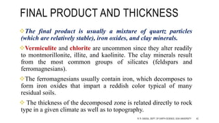
- 38. FINAL PRODUCT AND THICKNESS The final product is usually a mixture of quartz particles (which are relatively stable), iron oxides, and clay minerals. Vermiculite and chlorite are uncommon since they alter readily to montmorillonite, illite, and kaolinite. The clay minerals result from the most common groups of silicates (feldspars and ferromagnesians). The ferromagnesians usually contain iron, which decomposes to form iron oxides that impart a reddish color typical of many residual soils. The thickness of the decomposed zone is related directly to rock type in a given climate as well as to topography. R. R. GADGIL, DEPT. OF EARTH SCIENCE, GOA UNIVERSITY 42
- 39. The greatest depths of decomposition occur in tectonically stable areas. In unstable tectonic areas, the weathered zone is thinner because topographic changes increase the erosion activity. Glaciation removes decomposed materials, often leaving a fresh rock surface. In glaciated areas, the geologic time span for decomposition has been relatively short, and the depth of weathering is shallow. R. R. GADGIL, DEPT. OF EARTH SCIENCE, GOA UNIVERSITY 43
- 40. FINAL PRODUCT AND THICKNESS It is the partially saturated zones where vertical water movement can occur that provide the optimum conditions for oxidation, reduction, and leaching, and where decomposition is most active. Decomposition depth, often to depths in excess of 100 ft, is greatest beneath the crests of the hills composed of foliated crystalline rocks. Along the sideslopes, where erosion occurs, the depth is about 30 ft. In the narrow valleys, where rock is permanently saturated, the decomposed depth is usually only of the order of 10 ft at the most, and streams often flow on fresh rock surfaces. There is little decomposition activity below the permanent water table. Limestone cavities do not increase substantially in size unless water is caused to flow.R. R. GADGIL, DEPT. OF EARTH SCIENCE, GOA UNIVERSITY 44
- 41. FINAL PRODUCT AND THICKNESS R. R. GADGIL, DEPT. OF EARTH SCIENCE, GOA UNIVERSITY 45
- 42. R. R. GADGIL, DEPT. OF EARTH SCIENCE, GOA UNIVERSITY 46
- 43. R. R. GADGIL, DEPT. OF EARTH SCIENCE, GOA UNIVERSITY 47
- 44. R. R. GADGIL, DEPT. OF EARTH SCIENCE, GOA UNIVERSITY 48
- 45. WEATHERING PROFILE IN IGNEOUS ROCKS Quartz-rich sialic rocks undergo 4 stages of weathering development Stage 1 : Weathering proceeds first along the joints of the fresh rock surface, and decomposition is most rapid where the joints are closely spaced. The granite begins to alter in appearance; the biotite tends to bleach and lighten in color, and iron compounds migrate, staining the rock yellowish-red to reddish-brown. R. R. GADGIL, DEPT. OF EARTH SCIENCE, GOA UNIVERSITY 49
- 46. Stage 2 : During intermediate decomposition, the granite loses its coherence and becomes crumbly. In humid climates, a sandy matrix forms around spherical boulders (corestones), especially in partially saturated but continuously moist zones. The corestone size reflects the fracture spacing. In well-drained zones, Stage 2 soil cover is often relatively thin, and on steep slopes in granite the soil is removed quickly, and slabbing by exfoliation occurs. R. R. GADGIL, DEPT. OF EARTH SCIENCE, GOA UNIVERSITY 50
- 47. Stage 3 : During final decomposition, a sandy soil is formed, composed chiefly of angu lar particles of quartz and feldspar. Further decomposition yields clayey soils (Grim, 1962). The presence of “corestones” can be very significant in foundation investigations because of misinterpretation that bedrock is at a higher elevation than actual. R. R. GADGIL, DEPT. OF EARTH SCIENCE, GOA UNIVERSITY 51
- 48. In general, the quartz-poor mafic rocks develop a weathering profile, also typical of many metamorphic rocks, which is characterized by four zones: 1. An upper zone of residual soils that are predominantly clays with small amounts of organic matter (equivalent to the A and B horizons of pedological soils) 2. An intermediate zone of residual soil, predominantly clayey, but with decomposition less advanced than in the upper zone. 3. A saprolite zone in which relict rock structure is evident and the materials are only partially decomposed, which grades to a weathered rock zone 4. The weathered rock zone where rock has only begun alteration R. R. GADGIL, DEPT. OF EARTH SCIENCE, GOA UNIVERSITY 52
- 49. Clay soils are the product of decomposition. The clay type is related strongly to the rainfall and drainage environment (Grim, 1962) as follows: Low rainfall or poor drainage; montmorillonite forms as magnesium remains. High rainfall and good drainage; kaolinite forms as magnesium is removed. Hot climates, primarily wet but with dry periods; humic acids are lacking, silica is dissolved and carried away, and iron and aluminum are concentrated near the surface (laterization). Cold, wet climates; potent humic acids remove aluminum and iron and concentrate silica near the surface (silcrete). R. R. GADGIL, DEPT. OF EARTH SCIENCE, GOA UNIVERSITY 53
- 50. R. R. GADGIL, DEPT. OF EARTH SCIENCE, GOA UNIVERSITY 54
- 51. R. R. GADGIL, DEPT. OF EARTH SCIENCE, GOA UNIVERSITY 55
- 52. R. R. GADGIL, DEPT. OF EARTH SCIENCE, GOA UNIVERSITY 56
- 53. ATTERBERG LIMITS The Atterberg limits are a basic measure of the critical water contents of a fine-grained soil: its shrinkage limit, plastic limit, and liquid limit. As a dry, clayey soil takes on increasing amounts of water, it undergoes distinct changes in behavior and consistency. A fine-grained soil can exist in any of several states; which state depends on the amount of water in the soil system. When water is added to a dry soil, each particle is covered with a film of adsorbed water. If the addition of water is continued, the thickness of the water film on a particle increases. Increasing the thickness of the water films permits the particles to slide past one another more easily. The behavior of the soil, therefore, is related to the amount of water in the system. Approximately sixty years ago, A. Atterberg defined the boundaries of four states in terms of "limits" as follows R. R. GADGIL, DEPT. OF EARTH SCIENCE, GOA UNIVERSITY 57
- 54. ATTERBERG LIMITS Liquid limit: The boundary between the liquid and plastic states; Plastic limit: The boundary between the plastic and semi-solid states; Shrinkage limit: The boundary between the semi-solid and solid states. R. R. GADGIL, DEPT. OF EARTH SCIENCE, GOA UNIVERSITY 58
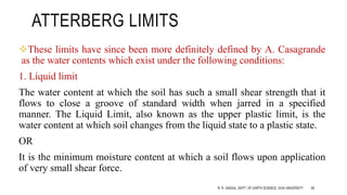
- 55. ATTERBERG LIMITS These limits have since been more definitely defined by A. Casagrande as the water contents which exist under the following conditions: 1. Liquid limit The water content at which the soil has such a small shear strength that it flows to close a groove of standard width when jarred in a specified manner. The Liquid Limit, also known as the upper plastic limit, is the water content at which soil changes from the liquid state to a plastic state. OR It is the minimum moisture content at which a soil flows upon application of very small shear force. R. R. GADGIL, DEPT. OF EARTH SCIENCE, GOA UNIVERSITY 59
- 56. ATTERBERG LIMITS 2. Plastic limit The water content at which the soil begins to crumble when rolled into threads of specified size. It is defined as “The moisture content at which the soil behaves like a plastic material is called plastic limit” “The moisture content at which the soil begins to crumble when rolled up into a thread of 3 mm in diameter” R. R. GADGIL, DEPT. OF EARTH SCIENCE, GOA UNIVERSITY 60
- 57. ATTERBERG LIMITS 3. Shrinkage limit: Shrinkage limit is defined as “the moisture content at which the soil change from a semi solid state to a solid state” R. R. GADGIL, DEPT. OF EARTH SCIENCE, GOA UNIVERSITY 61
- 58. SOIL FORMATIONS: GEOLOGIC CLASSES AND CHARACTERISTICS Soils are classified geologically by their origin as residual, colluvial, alluvial, eolian, glacial, or secondary soils. The various geologic classes exhibit characteristic modes of occurrence. Classifying soils by geologic origin, describing the formation in terms of their mode of occurrence, and considering both as related to climate, provide information on the characteristics of gradation, structure, and stress history for a given deposit. Knowledge of these characteristics provides the basis for formulating preliminary judgments on the engineering properties of permeability, strength, and deformability; for intelligent planning of exploration programs, especially in locations where the investigator has little or no prior experience; and for extending the data obtained during exploration from a relatively few points over the entire study area. R. R. GADGIL, DEPT. OF EARTH SCIENCE, GOA UNIVERSITY 62
- 59. SOIL FORMATIONS: GEOLOGIC CLASSES AND CHARACTERISTICS R. R. GADGIL, DEPT. OF EARTH SCIENCE, GOA UNIVERSITY 63
- 60. CLASSES AND MODE OF OCCURRENCE Residual Soils Developed in situ from the decomposition of rock, residual soils have geomorphic characteristics closely related to the parent rock. Colluvial Soils Colluvium refers to soils transported by gravitational forces. Their modes of occurrence relate to forms of landsliding and other slope movements such as falls, avalanches, and flows. Alluvial Soils Alluvium is transported by water. The mode of occurrence can take many forms generally divided into four groups and further subdivided. Eg. marine deposits. R. R. GADGIL, DEPT. OF EARTH SCIENCE, GOA UNIVERSITY 64
- 61. CLASSES AND MODE OF OCCURRENCE Fluvial or river deposits include stream bed, alluvial fan, and floodplain deposits (point bar, clay plugs, natural levees, back swamp), deposits laid down under rejuvenated stream conditions (buried valleys, terraces), and those deposited in the estuarine zone (deltas, estuary soils). Lacustrine deposits include those laid down in lakes and playas. Coastal deposits include spits, barrier beaches, tidal marshes, and beach ridges. Marine deposits include offshore soils and coastal-plain deposits. R. R. GADGIL, DEPT. OF EARTH SCIENCE, GOA UNIVERSITY 65
- 62. CLASSES AND MODE OF OCCURRENCE Eolian Soils: Eolian deposits are transported by wind and occur as dunes, sand sheets, loess, and volcanic dust. Glacial Soils: Soils deposited by glaciers or glacial waters can take many forms, subdivided into two groups: 1. Moraines are deposited directly from the glacier as ground moraine (basal till, ablation till, drumlins) or as end, terminal, and interlobate moraines. 2. Stratified drift is deposited by the meltwaters as fluvial formations (kames, kame terraces, eskers, outwash, kettles) or lacustrine (freshwater or saltwater deposition). Secondary Deposits: Original deposits modified in situ by climatic factors to produce duricrusts, permafrost, and pedological soils are referred to as secondary deposits. The duricrusts include laterite, ironstone (ferrocrete), caliche, and silcrete. R. R. GADGIL, DEPT. OF EARTH SCIENCE, GOA UNIVERSITY 66
- 63. FOUNDATION CONDITIONS Generally favorable foundation conditions are associated with (1) medium dense or denser soils characteristic of some stream channel deposits, coastal deposits, and glacial moraines and stratified drift; (2) overconsolidated inactive clays of some coastal plains; and (3) clay–granular mixtures characteristic of residual soils formed from sialic rocks. Marginal foundation conditions may be associated with glacial lacustrine clays and soils with a potential for collapse such as playa deposits, loess, and porous clays. Poor foundation conditions may be associated with colluvium, which is often unstable on slopes; granular soils deposited in a loose condition in floodplains, deltas, estuaries, lakes, swamps, and marshes; active clays resulting from the decomposition of mafic rocks and marine shales, or deposited as marine clays and uplifted to a coastal plain, or deposited by ancient volcanic activity; and all organic deposits. R. R. GADGIL, DEPT. OF EARTH SCIENCE, GOA UNIVERSITY 67
- 64. DESCRIPTIONS, PROPERTIES AND BEHAVIOR OF SOILS AND ROCKS R. R. GADGIL, DEPT. OF EARTH SCIENCE, GOA UNIVERSITY 68
- 65. DESCRIPTIONS, PROPERTIES AND BEHAVIOR OF SOILS AND ROCKS R. R. GADGIL, DEPT. OF EARTH SCIENCE, GOA UNIVERSITY 69
- 66. R. R. GADGIL, DEPT. OF EARTH SCIENCE, GOA UNIVERSITY 70
- 67. RESIDUAL SOILS Residual soils develop in situ from the disintegration and decomposition of rock. The distinction between rock and soil is difficult to make when the transition is gradual, as is the case with most rocks. Chemical decomposition produces the most significant residual soil deposits. Mechanical weathering produces primarily granular particles of limited thickness, except in marine shales. The depth and type of soil cover that develop are often erratic, since they are a function of the mineral constituents of the parent rock, climate, the time span of weathering exposure, orientation of weakness planes (permitting the entry of water), and topography.R. R. GADGIL, DEPT. OF EARTH SCIENCE, GOA UNIVERSITY 71
- 68. RESIDUAL SOILS-ROCK TYPE RELATIONS AND CLIMATE Igneous and metamorphic rocks composed of silicates and oxides produce thick, predominantly clay soils. Sandstones and shales are composed chiefly of stable minerals (quartz and clay), which undergo very little additional alteration. It is the impurities (unweathered particles and cementing agents) that decompose to form the relatively thin soil cover. Carbonates and sulfates generally go into solution before they decompose. The relatively thin soil cover that develops results from impurities. Marine and clay shales generally undergo mechanical weathering from swelling with some additional chemical decomposition. Soil profile development is related primarily to rainfall, but temperature is an important factor. Very little soil cover develops in either a cool-dry or hot-dry climate. Cool-wet zones produce relatively thick soil cover, but tropical climates with combinations of high temperatures and high rainfall produce the greatest thicknesses. R. R. GADGIL, DEPT. OF EARTH SCIENCE, GOA UNIVERSITY 72
- 69. COLLUVIAL DEPOSITS Colluvial soils are materials displaced from their original location of formation, normally by gravitational forces during slope failures. They typically represent an unstable mass, often of relatively weak material, and are frequently found burying very weak alluvial soils. Their recognition, therefore, is important. Mode of Occurrence Colluvium is found on slopes, or at or far beyond the toe of a slope. Displacements from the origin can vary from a few inches to feet for creep movements, to tens of feet for rotational slides, and many feet or even miles for avalanches and flows. R. R. GADGIL, DEPT. OF EARTH SCIENCE, GOA UNIVERSITY 73
- 70. COLLUVIAL DEPOSITS R. R. GADGIL, DEPT. OF EARTH SCIENCE, GOA UNIVERSITY 74
- 71. ENGINEERING SIGNIFICANCE – UNSTABLE MASSES When colluvium rests on a slope, it normally represents an unstable condition, and further slope movements are likely. In slides, the mass is bounded by a failure surface along which residual (or slightly higher) strengths prevail, representing a weakness surface in the mass that is often evidenced by slickensided surfaces. The unconformable mass on the slope blocks the normal slope seepage and evaporation because of its relative impermeability, resulting in pore-pressure buildup during the rainy season, and a further decrease in stability. R. R. GADGIL, DEPT. OF EARTH SCIENCE, GOA UNIVERSITY 75
- 72. ENGINEERING SIGNIFICANCE – UNSTABLE MASSES Slope movements of colluvium are common, and before total failure range from the barely perceptible movements of creep to the more discernible movements of several inches per week. Movements are normally periodic, accelerating and decelerating, and stopping completely for some period of time (the slip-stick phenomenon). The natural phenomena causing movements are rainfall, snow and ice melt, earthquake-induced vibrations, and changing levels of adjacent water bodies resulting from floods and tides. Cuts made in colluvial soil slopes can be expected to become much less stable with time and usually lead to failure, unless retained. R. R. GADGIL, DEPT. OF EARTH SCIENCE, GOA UNIVERSITY 76
- 73. ALLUVIAL DEPOSITS Fluvial refers to river or stream activity. Alluvia are the materials carried and deposited by streams. The stream channel is the normal extent of the flow confined within banks, and the floodplain is the area adjacent to the channel which is covered by overflow during periods of high runoff. It is often defined by a second level of stream banks. Intermittent streams flow periodically, and a wash, wadi, or arroyo is a normally dry stream channel in an arid climate. R. R. GADGIL, DEPT. OF EARTH SCIENCE, GOA UNIVERSITY 77
- 74. ALLUVIAL DEPOSITS Fluvial refers to river or stream activity. Alluvia are the materials carried and deposited by streams. The stream channel is the normal extent of the flow confined within banks, and the floodplain is the area adjacent to the channel which is covered by overflow during periods of high runoff. It is often defined by a second level of stream banks. Intermittent streams flow periodically, and a wash, wadi, or arroyo is a normally dry stream channel in an arid climate. R. R. GADGIL, DEPT. OF EARTH SCIENCE, GOA UNIVERSITY 78
- 75. ALLUVIAL DEPOSITS Meandering of the Colorado River in rejuvenated plateau of sedimentary rocks. R. R. GADGIL, DEPT. OF EARTH SCIENCE, GOA UNIVERSITY 79
- 76. ALLUVIAL DEPOSITS Geologist needs to have knowledge of • Boulder zone (also headwater tract, young or early stage) • Floodway zone (also valley tract, mature or middle stage) • Pastoral zone (also plain tract, old age or late stage) • Estuarine zone (at the river’s mouth) Rejuvination, Buried channels. Straight channels, croocked channels, braided channels, meandering streams, oxbow lakes. Their sedimentary characteristics. Discussing each in detail, is out of scope of this lecture. R. R. GADGIL, DEPT. OF EARTH SCIENCE, GOA UNIVERSITY 80
- 77. ENGINEERING CHARACTERISTICS OF FLUVIAL SOILS R. R. GADGIL, DEPT. OF EARTH SCIENCE, GOA UNIVERSITY 81
- 78. ENGINEERING CHARACTERISTICS OF FLUVIAL SOILS Fluvial deposits are typically stratified and extremely variable, with frequent interbedding. Permeability in the horizontal direction is significantly greater than in the vertical direction. Unless subjected to the removal of overburden by erosion or desiccation, the deposits are normally consolidated. Clays are soft and sands are in the loose- to medium dense state. Boulders, Cobbles, and Gravel The coarser sizes occur in the beds of youthful streams, in buried channels, and in the upper portions of alluvial fans in arid climates. Permeability in these zones is very high. Sands and Silts Sands and silts are the most common fluvial deposits, occurring in all mature- and late-stage stream valleys as valley fills, terraces, channel deposits, lag deposits, point bars, and natural levees. They are normally consolidated and compressible unless prestressed by overburden subsequently removed by erosion, or by water table lowering during uplift. R. R. GADGIL, DEPT. OF EARTH SCIENCE, GOA UNIVERSITY 82
- 79. ENGINEERING CHARACTERISTICS OF FLUVIAL SOILS Silty sands deposited as valley fill in an arid environment are often lightly cemented with salts and other agents, and prone to collapse upon saturation following the initial drying. Clays Clay soils are not encountered in the boulder zone and are relatively uncommon in the floodway zone, except for deposits along the river banks and on the valley floor during flood stages. In these deposits the soils are usually clayey silts. In the backswamp areas, clays are generally interbedded with silts and sands and are often organic, containing root fibers. R. R. GADGIL, DEPT. OF EARTH SCIENCE, GOA UNIVERSITY 83
- 80. ENGINEERING CHARACTERISTICS OF FLUVIAL SOILS R. R. GADGIL, DEPT. OF EARTH SCIENCE, GOA UNIVERSITY 84
- 81. ENGINEERING CHARACTERISTICS OF FLUVIAL SOILS R. R. GADGIL, DEPT. OF EARTH SCIENCE, GOA UNIVERSITY 85
Editor's Notes
- Practical Engineering Geology by Hencher pg185
- Engineering Geology by Krynine and Judd pg46-47
- Engineering properties of rocks pg40
- Engineering Geology Principles and practice pg33
- Engineering Geology Principles and practice pg33
- Engineering Geology by Krynine and Judd pg48
- Practical Engineering Geology by Hencher pg185
- Practical Engineering Geology by Hencher pg185
- Practical Engineering Geology by Hencher pg185
- Practical Engineering Geology by Hencher pg186
- Practical Engineering Geology by Hencher pg186
- Engineering Geology by Krynine and Judd pg49
- Engineering Geology by Krynine and Judd pg49
- Engineering Geology by Krynine and Judd pg51
- Engineering Geology by Krynine and Judd pg52
- Engineering properties of rocks pg43
- http://civilblog.org/2014/04/28/point-load-strength-index-test-of-rock-is-8764/
- Engineering properties of rocks pg36
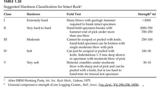
- Engineering properties of rocks pg43 International Society for Rock Mechanics ISRM Ayday and Grktan (1992) developed the following empirical correlation between L and N-type Schmidt hammer rebound numbers for the ISRM (1978b) test procedure Rn(N) = 7.124 + 1.249Rn(L) (r2 = 0.882) where Rn(L) and Rn(N) are, respectively, the L and N-type Schmidt hammer rebound numbers; and r2 is the determination coefficient.
- Engineering properties of rocks pg43 International Society for Rock Mechanics ISRM
- Engineering properties of rocks pg44
- Engineering properties of rocks pg43 Slaking = Combine (quicklime) with water to produce calcium hydroxide
- Engineering properties of rocks pg43
- Characteristics of Geological Materials and foundations – A field guide pg39
- Characteristics of Geological Materials and foundations – A field guide pg40
- Characteristics of Geological Materials and foundations – A field guide pg41
- Characteristics of Geological Materials and foundations – A field guide pg40
- Characteristics of Geological Materials and foundations – A field guide pg40
- Engineering Geology by Krynine and Judd pg78
- Engineering Geology by Krynine and Judd pg78
- Engineering Geology by Krynine and Judd pg78
- Engineering Geology by Krynine and Judd pg78
- Characteristics of Geological Materials and foundations – A field guide pg131
- Characteristics of Geological Materials and foundations – A field guide pg131
- Characteristics of Geological Materials and foundations – A field guide pg132
- Characteristics of Geological Materials and foundations – A field guide pg132
- Characteristics of Geological Materials and foundations – A field guide pg132
- Characteristics of Geological Materials and foundations – A field guide pg135
- Characteristics of Geological Materials and foundations – A field guide pg135
- Characteristics of Geological Materials and foundations – A field guide pg138
- Characteristics of Geological Materials and foundations – A field guide pg139
- Characteristics of Geological Materials and foundations – A field guide pg140
- Characteristics of Geological Materials and foundations – A field guide pg140
- Engineering Properties of rocks pg116
- Engineering Properties of rocks pg117
- Engineering Properties of rocks pg118
- Engineering Properties of rocks pg118
- Characteristics of Geological Materials and foundations – A field guide pg142
- Characteristics of Geological Materials and foundations – A field guide pg143
- Characteristics of Geological Materials and foundations – A field guide pg140
- Characteristics of Geological Materials and foundations – A field guide pg145
- Characteristics of Geological Materials and foundations – A field guide pg146
- Characteristics of Geological Materials and foundations – A field guide pg146
- Characteristics of Geological Materials and foundations – A field guide pg146
- Characteristics of Geological Materials and foundations – A field guide pg146
- http://www.aboutcivil.org/atterberg-limits.html
- http://www.aboutcivil.org/atterberg-limits.html
- http://www.aboutcivil.org/atterberg-limits.html
- http://www.aboutcivil.org/atterberg-limits.html
- http://www.aboutcivil.org/atterberg-limits.html
- Characteristics of Geological Materials and foundations – A field guide pg159
- Characteristics of Geological Materials and foundations – A field guide pg270
- Characteristics of Geological Materials and foundations – A field guide pg159
- Characteristics of Geological Materials and foundations – A field guide pg160
- Characteristics of Geological Materials and foundations – A field guide pg160
- Characteristics of Geological Materials and foundations – A field guide pg161
- Characteristics of Geological Materials and foundations – A field guide pg162
- Characteristics of Geological Materials and foundations – A field guide pg162
- Characteristics of Geological Materials and foundations – A field guide pg162
- Characteristics of Geological Materials and foundations – A field guide pg161
- Characteristics of Geological Materials and foundations – A field guide pg161
- Characteristics of Geological Materials and foundations – A field guide pg178
- Characteristics of Geological Materials and foundations – A field guide pg178
- Characteristics of Geological Materials and foundations – A field guide pg179
- Characteristics of Geological Materials and foundations – A field guide pg179
- Characteristics of Geological Materials and foundations – A field guide pg182
- Characteristics of Geological Materials and foundations – A field guide pg182
- Characteristics of Geological Materials and foundations – A field guide pg182
- Characteristics of Geological Materials and foundations – A field guide pg182
- Characteristics of Geological Materials and foundations – A field guide pg183
- Characteristics of Geological Materials and foundations – A field guide pg183
- Characteristics of Geological Materials and foundations – A field guide pg183
- Characteristics of Geological Materials and foundations – A field guide pg200
- Characteristics of Geological Materials and foundations – A field guide pg200