


An Introduction to Housing: Core Concepts and Historical Evolution from Prehistory to the Industrial Revolution
- 1. EVOLUTION OF HOUSING URBAN HABITAT STUDIO ADITI SHANDILYA (MA 01/22) ANCHAL THAPA (MA 04/22) GUNJOT KAUR (MA 10/22)
- 2. ? Definition of a Housing Neighbourhood A neighbourhood is the vicinity in which people live. Lewis Mumford presented ‘neighbourhood’ as a ‘fact of nature’, which comes into existence whenever a group of people share a place. Arnold Whittick (1974) describes neighbourhood unit as an integrated, and planned urban area related to the larger community of which it is a part, and consisting of residential districts, a school or schools, shopping facilities, religious buildings, open spaces, and perhaps a degree of service industry. The British New Towns Committee in 1946 stated that the neighborhood is a natural and useful conception, but it should not be thought of as a self-contained community of which the inhabitants are more conscious than they are of the town as whole (Gallion, 1984). Introduction Efficiency FUNDAMENTAL CORE Flexibility Adaptability Basic human needs & quality of life AIM & TARGET Suggest Sense of place Urban memory & identity Adjustment over time Humanistic approach Sources : • What is a Neighbourhood? The Structure and Function of an Idea, by rachel kullas, hubert law • Residential density and 20-minute neighbourhoods: A multi-neighbourhood destination location optimisation approach 2
- 3. Evolution of a Housing Neighbourhood To explore the evolution of neighbourhoods, a timeline spanning from prehistory 2.5 million years ago to the early 19th- century industrial revolution was established. Various global regions, as illustrated in the figure below, were selected to analyse and identify parameters characterizing neighbourhoods during each era.
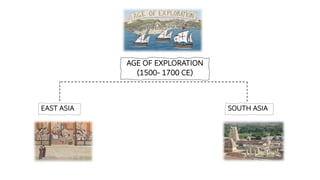
- 4. 2.5 mya - 3500 BCE PREHISTORY • Palaeolithic Period • Mesolithic period • Neolithic Period 3500 BCE- 500 CE ANCIENT HISTORY ▪ East Asia Chinese ▪ South Asia Indus ▪ Africa Egyptian ▪ West Asia Mesopotamia ▪ Europe Greek Roman 500 - 1500 CE MEDIEVAL PERIOD • East Asia • South Asia • Africa • West Asia • Europe 1500– 1700 CE AGE OF EXPLORATION • East Asia • South Asia • Africa • West Asia • Europe 1800 - Early 1900 CE INDUSTRIAL REVOLUTION • Europe TIMELINE Source: • Norwich, J. J. (1984). The World atlas of architecture. Portland House. • Ching, F. D., Jarzombek, M. M., & Prakash, V. (2017). A global history of architecture. John Wiley & Sons.
- 5. Paleolithic Era or old stone age (2.5 mya) Mesolithic Era or Middle Stone Age (15000 years ago) TRANSITION Drivers of Evolution: ▪Human societal behaviour & way of life. ▪Climate change and to adjust to the plants and animals behaviour patterns. ▪Change from hunter gatherer to agriculture. ▪Origination of semi-permanent settlements (like base camp). ▪Relocation pattern. 2.5 mya - 3500 BCE | PREHISTORY Characteristics: - Dependency on nature - Nomadic society of settlement - Afghanistan Cave Dwellings Growth of Settlements Neolithic Era or New stone age (11000 years ago) Characteristics: ▪ Permanent settlement and dwellings became more sustainable (mud and stone house). ▪ Agriculture & domestication flourished. ▪ Burial grounds for rituals of dead. Housing Mud & stone houses with compounds for cattle. Burial Storehouse Agriculture Domestication Farms IDENTIFIED PARAMETERS OF NEIGHBOURHOOD Adaptation to climate Origin of occupation (Agriculture & Domestication) Birth of Faith/religion Recognition of social links by introduction of Burials. Symbolism and Identity by art.
- 6. 3500 BCE - 500 CE | ANCIENT HISTORY EAST ASIA Chinese Civilization WORLD CIVILIZATIONS SOUTH ASIA Indus Valley Civilization WEST ASIA Mesopotamia Civilization AFRICA Egyptian Civilization EUROPE Ancient Greek & Roman Civilization
- 7. 3500 - 500 CE | ANCIENT HISTORY West Asia 3500 BCE Mesopotamia | Catal hüyük, Turkey Characteristics: ▪Village-world farming & domestication beginning. ▪Village Communities developed. (Clan lineages & chieftains) ▪Occupation shift to trade (supply of blades made from rare black volcanic rock). Rectangular flat roofed packed settlement forming a single architecture mass. High Density Occupational needs Community & Social Interaction Site Plan (Population-8000) IDENTIFIED PARAMETERS OF NEIGHBOURHOOD • No street or passageways. • Movement within the settlement happened across rooftops. • No central communal scared space (Individual religious practice). • Transformation of urban fabric from houses to ancestors shrines. Identity
- 8. 3500 - 500 CE | ANCIENT HISTORY South Asia 2500 BCE Indus valley civilization | Mohenjo-Daro Characteristics: ▪Grid pattern planned settlement following standardization. ▪Shared services: Special public structures like Warehouse, The Great Bath (for ritual baths). ▪Privacy provisions: Walled lower town with divisions between private and public spaces. Site Plan of Mohenjo-Daro (620 acres) Plan highlighting lower town- • A complex of private and public houses, wells, shops and commercial buildings. • Right angled street network pattern. • Idea of drainage system • Major cluster blocks is 19.20 m; minor individual blocks is 9.60 m. • The settlement blocks and dwelling clusters of Mohenjo-Daro, follow the orthogonal pattern. • Implementation of rules of Vaastu Shastra. Drivers of evolution: • Economic, religious, and socio-political functions. • Housing blocks (10,000 people) DK Area VS Area Grid Modules of Mohenjo-Daro Layout of settlement blocks & street planning
- 9. Well defined boundary lines, which either coincide with the street or lane, or are separated with the adjoining cluster block Main Street closely coincide and align with the grid network while secondary lanes are staggered & end in culde-sacs Widest area with high density of built clusters. Typical Cluster block - Streets and Lanes in HR Area, Mohenjo-Daro Safety & Security Connectivity Basic Utilities Comfort Community & Social Interaction Shared services IDENTIFIED PARAMETERS OF NEIGHBOURHOOD 9.6 m x 9.6 m as one of the standard plot sizes. Thick walls for privacy , also serving as walkable shaded streets.
- 10. 3500 - 500 CE | ANCIENT HISTORY Africa 1550–1069 BCE Egyptian | Amarna (ancient Akhetaten) Identity Socio-economic hierarchy Occupational needs Religion/ Cult IDENTIFIED PARAMETERS OF NEIGHBOURHOOD Site Plan (Population-50,000) Characteristics: ▪Organic city planning ▪Birth of burial landscape: Cemeteries / burial grounds as natural landscape. ▪Social-economic impact on burial grounds. ▪Introduction of suburbs with large houses & personal farms. Peripheral Farming & labourers communities (non-elite) Core city : Cluster of temples, palaces and civic buildings. Hub of urban industry: • Clustered houses of workers, craftsmen & artisans. • Lack of direction of the city. Residences of High-rank officials Manufacturing practices for production of good.
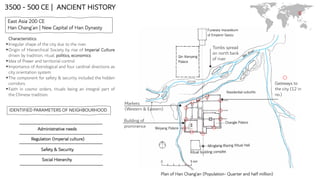
- 11. 3500 - 500 CE | ANCIENT HISTORY East Asia 200 CE Han Chang’an | New Capital of Han Dynasty Characteristics: ▪Irregular shape of the city due to the river. ▪Origin of Hierarchical Society by rise of Imperial Culture driven by tradition, ritual, politics, economics ▪Idea of Power and territorial control. ▪Importance of Astrological and four cardinal directions as city orientation system. ▪The component for safety & security included the hidden corridors. ▪Faith in cosmic orders, rituals being an integral part of the Chinese tradition. Markets (Western & Eastern) Plan of Han Chang’an (Population- Quarter and half million) Building of prominence Tombs spread on north bank of river Safety & Security Social Hierarchy Regulation (Imperial culture) IDENTIFIED PARAMETERS OF NEIGHBOURHOOD Gateways to the city (12 in no.) Administrative needs
- 12. 3500 - 500 CE | ANCIENT HISTORY Europe Mycenae, Greece | 1500 BCE Plan of Mycenaean city Administration centre & Regional Industrial production Fortified walls for protection Linear clustered residential zone Characteristics: ▪Diverse occupations in industrial sector ▪Construction advancement : ramps, bridges, dams in city planning. The original square of the town was divided into small A Perfect Grid: The Roman Town of Timgad • Compact small-scale cities networked with landscape. insulae, mostly residential and commercial (21 by 21 m) and each one including one or more houses. Central public spaces formed the origin . Around which the city grew. Shared services Connectivity IDENTIFIED PARAMETERS OF NEIGHBOURHOOD Occupational needs Privacy & Security
- 13. MEDIEVAL PERIOD (500- 1500 CE) EAST ASIA SOUTH ASIA AFRICA WEST ASIA EUROPE
- 14. Offices, administration, ritual and ceremonial halls. (5% of entire city area) WEST Fortification around the settlements for security. Grid pattern of roads lined with drainage channels and shaded by rows of trees. 9.72 km 8.65 km NORTH SOUTH EAST East and west markets Stream flowing through the settlements providing Water supply throughout the area and the gardens/ city parks. 108 neighborhood blocks called fangs. 618-907 CE | REGION OF CHINA : DAXING CHANG’AN, THE TANG CAPITAL World Map Showing East Asia Region Of China With Tang Dynasty
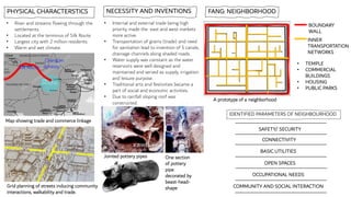
- 15. • River and streams flowing through the settlements. • Located at the terminus of Silk Route. • Largest city with 2 million residents. • Warm and wet climate. PHYSICAL CHARACTERSTICS Silk Route Chang’an dynasty Map showing trade and commerce linkage Grid planning of streets inducing community interactions, walkability and trade. FANG: NEIGHBORHOOD • Internal and external trade being high priority made the east and west markets more active. • Transportation of grains (trade) and need for sanitation lead to invention of 5 canals, drainage channels along shaded roads. • Water supply was constant as the water reservoirs were well designed and maintained and served as supply, irrigation and leisure purpose. • Traditional arts and festivities became a part of social and economic activities. • Due to rainfall sloping roof was constructed. NECESSITY AND INVENTIONS A prototype of a neighborhood BOUNDARY WALL INNER TRANSPORTATION NETWORKS • TEMPLE • COMMERCIAL BUILDINGS • HOUSING • PUBLIC PARKS Jointed pottery pipes SAFETY/ SECURITY BASIC UTILITIES OCCUPATIONAL NEEDS COMMUNITY AND SOCIAL INTERACTION OPEN SPACES CONNECTIVITY One section of pottery pipe decorated by beast-head- shape IDENTIFIED PARAMETERS OF NEIGHBOURHOOD
- 16. 841–878 CE | REGION OF INDIA : THANJAVUR, TANJORE (CHOLA DYNASTY) World Map Showing South Asia Region Of India, Thanjavur Fortification and moat surrounding the 2 forts PHYSICAL CHARACTERSTICS • Vadavaru channel near banks of river Krishna flowing around the settlement provides with water supply, trade and fortification with creation of moat. • Temple town as a religious, political and economic base. • Topography of site utilized by placing the temple on the raised grounds. Big fort • Palace • Residential area Small fort • Temple • Siva ganga garden • Water tank N 4 main streets Water channel Map of Tanjore city Gate connecting to the other village for sharing goods and services
- 17. NECESSITY AND INVENTIONS • Water tank to store water for various uses. • Downwards irrigation network built constitutes to its agrarian economy. • Temple as a multifunctional corporation serving as religious and judicial functions. • Social stratification on the basis of caste for facilities like education and religious rituals. • Economic base for trade through sea and . land revenue and trade tax main sources of revenue . • The elites and power groups occupied the spatial ring around the ‘ceremonial center’ of temple, while the artisan and service groups lived in the outer ring. • Well-planned army consisting of elephants, cavalry, infantry and navy. • Moat around the settlement for safety and security. • Maintained hospitals for their people. • Major feature of this town was the market. It was filled with traders selling food grains like wheat and millet. Spices, jewellery and clothes were the major items in the market. VILLAGE NEIGHBORHOOD •Divided into mandalams and each mandalam into valanadus and nadus it were a number of autonomous villages. • 2 types of villages one with people from different caste and the assembly called ‘ur' and second type of village was ‘agrahara’ types of village which were settled by brahmins in which most of the land was rent-free. •The community of priests, artisans, labourers, businessmen and others resided near the temple as they were dependent on the temple for their livelihood. Transport advancement with logs of wood Grand Anicut dam was built to support agriculture RELIGION AMENITIES CONNECTIVITY SAFETY/ SECURITY REGULATION SOCIO-ECONOMIC HIERARCHY OCCUPATIONAL NEEDS IDENTIFIED PARAMETERS OF NEIGHBOURHOOD
- 18. 1000 CE | REGION OF AFRICA : GREAT ZIMBABWE World Map Showing Region of Africa, Great Zimbabwe Hill complex, placed on highest hill top.. (spiritual and Religious center) Great Enclosure, walled, circular area, accommodate a surplus population and site for religious rituals Valley Ruins, houses made of mud-brick (daga) for about 2,000 goldsmiths, potters, weavers, blacksmiths and stonemasons ,hub for commercial exchange and long distance trade. Roads Granite outcrop Wooded areas and trees Map of, Great Zimbabwe Residential area, Royal court, Market, Warehouses, Religious shrines
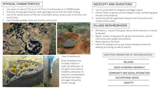
- 19. PHYSICAL CHARACTERSTICS • city covers an area of 7.22 sq. km (2.79 sq. m) and housed up to 20,000 people. • Economy through gold reserves, trade, good agricultural land and cattle herding. • Use of the natural terrain of the site to distribute various zones as per its function and social strata. • Use of locally available stone and mud for construction. • Mumbahuru- house of the great woman (built extension of natural landscape). • Kgotla- outdoor living space for garden and livestock, used for communion with people and ancestors. • Palace placed at the heart. • Interior furnishings such as pot-stands, elevated surfaces for sleeping and sitting, as well as hearths. NECESSITY AND INVENTIONS • Use of curved walls for longevity and bigger spaces. • Conical Tower as granary and for religious rituals, symbolizing good harvests and prosperity. • social and political organization became more hierarchical and strong military power. View of settlements VILLAGE NEIGHBORHOOD RELIGION COMMUNITY AND SOCIAL INTERACTION IDENTITY OCCUPATIONAL NEEDS Great Zimbabwe have included a decline in trade, the exhaustion of the gold mines, political instability, exhaustion of resources, overpopulation and famine and water shortages induced by climatic change. SOCIO-ECONOMIC HIERARCHY IDENTIFIED PARAMETERS OF NEIGHBOURHOOD
- 20. 762–766 CE | REGION OF WEST ASIA : BAGHDAD World Map Showing Region of West Asia, Baghdad Map of Baghdad deep moat ringed the outer wall perimeter. Royal precinct and mosque homes for the royal staff and servants, kitchens, barracks for the horse guard and other state offices Royal gardens residential and commercial buildings Tigris river Main streets connecting the central core
- 21. PHYSICAL CHARACTERSTICS • Created by adopting a stereographic projection of the equator and the tropics of cancer and Capricorn. • Located at the crossroads of silk road trade routes. • Located between Euphrates and Tigris, where the channels connected both rivers. • Round city with 3 concentric walls 2.5 to 3km diameter with 2 million population.. • 4 entry gates • Signifies temporal and spiritual authority.. • Irrigation canals that supported a multitude of gardens and farms. • city of museums, hospitals, libraries, mosques and an observatory. • wall used to separate the public and private spaces. NECESSITY AND INVENTIONS Silk route Baghdad Map of silk route through Baghdad VILLAGE NEIGHBORHOOD • Symmetric streets surrounded by geometrical residential blocks. • The third inner wall divided the city into private houses and open courtyards. • Public places for inhabitants. • Merchants built bazaars and houses around the southern gate due to expansion and more trade opportunities. • Privacy and hierarchy of open spaces was the main element. • mutual correlation through the social dimensions and economic factors and correlation with its commercial center through streets. View of axial street and residential around it. RELIGION CONNECTIVITY OPEN SPACE ADMINISTRATIVE NEEDS AMENITIES Reasons of decline were partly natural (vast flooding, crop failure and fires), and partly human-made (rivalry and internal security problems). OCCUPATIONAL NEEDS IDENTIFIED PARAMETERS OF NEIGHBOURHOOD
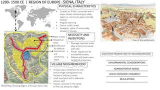
- 22. 1200- 1500 CE | REGION OF EUROPE : SIENA, ITALY World Map Showing Region of Europe, Siena, Italy PHYSICAL CHARACTERSTICS • Located on 3 hills- connected with 3 major streets intersecting at valley region i.e. community place centrally located. • Irregular planning • Cavina- public street • treseppio- space of narrow alley between 2 houses. Fortification for defense. Major streets Residential areas Commercial and community space NECESSITY AND INVENTIONS • Drainage channels under alley buried and covered with tiles. • Proper regulations for encroached streets. • Palaces and towers were symbol of aristocracy. View of the settlements VILLAGE NEIGHBORHOOD • A tower was a testament to rank and privilege raising above tiny houses of ordinary citizen. • small courtyard, with a defensive exterior wall. • Houses clustered in the center of the city, along the ridges. ADMINISTRATIVE NEEDS SOCIO-ECONOMIC HIERARCHY ENVIORNMENTAL CONSIDERATIONS REGULATIONS IDENTIFIED PARAMETERS OF NEIGHBOURHOOD
- 23. AGE OF EXPLORATION (1500- 1700 CE) EAST ASIA SOUTH ASIA
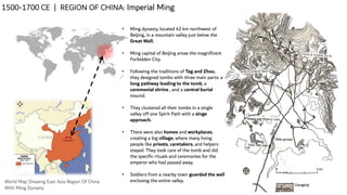
- 24. 1500-1700 CE | REGION OF CHINA: Imperial Ming World Map Showing East Asia Region Of China With Ming Dynasty • Ming dynasty, located 42 km northwest of Beijing, in a mountain valley just below the Great Wall. • Ming capital of Beijing arose the magnificent Forbidden City. • Following the traditions of Tag and Zhou, they designed tombs with three main parts: a long pathway leading to the tomb, a ceremonial shrine , and a central burial mound. • They clustered all their tombs in a single valley off one Spirit Path with a singe approach. • There were also homes and workplaces, creating a big village, where many living people like priests, caretakers, and helpers stayed. They took care of the tomb and did the specific rituals and ceremonies for the emperor who had passed away. • Soldiers from a nearby town guarded the wall enclosing the entire valley.
- 25. Walls were important to the Chinese psyche even in the secure capital, they felt the need to retreat behind them The main hall was the most northerly and usually reserved for the eldest of the family, such as the grandparents. The open courtyard lets in both the sunlight and the wind and cold. The more halls and courtyards a house has, the more impressive it looks Entrance is at the south eastern comer as prescribed by feng shu Screen Wall for privacy • Layout and Design: Houses in the Ming Dynasty were typically designed with a courtyard-style layout. The main living spaces were built around a central courtyard, providing natural light and ventilation. • Materials and Construction: The elite and wealthy families used higher-quality materials like wood and bricks, while commoners used materials such as rammed earth and bamboo. • Social Hierarchy: Housing varied greatly based on social status. The emperor, nobles, and high-ranking officials had grand palaces and estates with extensive gardens and multiple structures. Commoners lived in smaller houses, oftenly with shared courtyard spaces. • Urbanization and City Planning: During the Ming Dynasty, cities became more organized and planned. Walls, gates, and moats were constructed around many cities for defense. Typical Ming Housing SAFETY & SECURITY OCCUPATIONAL NEEDS COMMUNITY AND SOCIAL INTERACTION ADMINISTRATIVE NEEDS RELIGION IDENTIFIED PARAMETERS OF NEIGHBOURHOOD
- 26. 1500-1700 CE | REGION OF INDIA : VIJAYNAGAR World Map Showing East Asia Region Of INDIA • The brothers Harihara and Bukka Sangama established their capital Vijayanagar in on the Tungabhadra river, about 120km west of Mysore in Karnataka. • Even though they supported Hinduism, they took many ideas from the impressive architecture of their Islamic neighbors. • The city of Vijayanagara is spread across a space of about 26 square kilometers. • It is surrounded by the Tungabhadra river to the north and the Sandur hills to the south. SAFETY AND SECURITY SOCIO-ECONOMIC HIERARCHY CONNECTIVITY RELIGION BASIC UTILITIES IDENTIFIED PARAMETERS OF NEIGHBOURHOOD
- 27. • Massive fortifications with gateways surround the Urban Core. • In one area, a moat is preserved. The Urban Core consists of residential quarters of various social groups from different occupations and religious traditions, including Islam • Gateways, aligned buildings and pavements indicate major roads, while stairways suggest numerous pedestrian routes that linked the different residential areas. • An artificial irrigation canal, the Turtha Kalure. • The zone to the north of the valley is characterised by a rocky and uneven landscape, whereas the southern zone is situated in plains. • The rocky zone to the north of the valley contains numerous temples and shrines, partly surrounded by fortifications • Four temple complexes, the Virupaksa, Balkrishna, Achyut Raya and Vitthala are situated in prominent positions. • Royal centre is divided by high walls tightly interlocking enclosures which can be through elaborate gateways and small doorways. • Bounded on the north by the Tungabhadra river and on the south by the Sandur hills.
- 28. 1800 - Early 1900 CE | INDUSTRIAL REVOLUTION Europe | London Plan of London Poverty 1898-1899 showing The Old Nichol area High density Proximity to work & Services Occupational needs Socio-economic Hierarchy IDENTIFIED PARAMETERS OF NEIGHBOURHOOD Characteristics: ▪Housing became more overcrowded, development of slum neighbourhoods. ▪Isolation from the main city. ▪Urban spatial problem with lack of open spaces, poor transport. The streets are colored to represent the economic class • Red ("Lower middle class - Well-to-do middle class"), • Pink ("Fairly comfortable good ordinary earnings"), • Blue ("Intermittent or casual earnings"), • Black ("lowest class...occasional labourers, street sellers, loafers, criminals and semi-criminals")
- 29. ERA CHARACTERSTICS SHORTCOMINGS IDENTIFIED PARAMETERS LEARNINGS PREHISTORY • Adaption to climate change. • Transformation of semi permanent settlements to permanent settlements. • Recognition of social links by the birth of religion. • Dependency on limited occupation. • Limited infrastructure. • Lack of shared services. • Adaptation to climate • Origin of occupation Birth of Faith/religion • Recognition of social links by introduction of Burials. • Symbolism and Identity by art. • Concept of Environmental responsiveness design. • Use locally available materials. ANCIENT HISTORY • Adaption to growing needs. • Shift to specialised occupations. • Introduction to administrative governance. • Well organised settlements. • Spatial stratification due to social hierarchy. • Shared services. • Established community identity. • Religious and cultural restrictions. • limited social mobility. • Inadequate security. • Occupational/ Administrative needs • Basic utilities • Religion • Connectivity • Shared services • Spirit of community • Importance of shared services to improve social cohesion • Well organised networking for ease of access • technically advanced basic utilities . • Climate considerations. MEDIEVAL PERIOD • Social links through transportation and trade. • Addition of defensive infrastructure. • Technological advancement in basic services. • Awareness to healthcare and educational facilities. • Introduction to regulations. • open spaces as the main element. • Trade barriers due to poor connectivity. • Environmental impacts. • Religious and cultural restrictions. • Safety and security • Religion • Socio economic hierarchy • Administrative needs • Environmental considerations • Integrating available resources to accommodating changing needs. • Importance of policies and regulations. • Socio economic and environmental sustainability. • Incorporating hierarchy of private and semi private open spaces in neighbourhood for quality life. AGE OF EXPLORATION • Global trade flourished. • Establishment of port cities. • Religious diversities and mixed communities. • Economic disparities. • Affluent architectural style. • Colonial exploitation. • Loss of land and resources. • Social disruption. • Destruction of heritage. • Safety and security • Religion • Basic utilities • Experimenting with detailing for identity. • Provision for long term impact. • Importance of heritage preservation. • Introduction of large scale public green spaces. INFERENCES