


basic-geology-unit 1.pptx
- 2. ENGINEERING GEOLOGY • Engineering geology is the application of geology for safe and economic design. • Engineering geological studies may be performed during the planning, environmental impact analysis, civil or structural engineering design, value engineering and construction phases of public and private works projects, and during post-construction and forensic phases of projects. • Soil/Rock deformability pattern, stability are main concern o f Engineering Geology.
- 3. HISTORY OF ENGINEERING GEOLOGY The first book entitled Engineering Geology was published in 1880 b y William Penning. The first American engineering geology text book was written in 1914 by Ries and Watson. The need for geologist on engineering works gained world wide attention in 1928 with the failure of the St. Francis dam in California and the loss of 426 lives. More engineering failures which occurred the following years also prompted the requirement for engineering geologists to work on large engineering projects.
- 4. IMPORTANCE OF ENGINEERING GEOLOGY IN DEVELOPMENT • To recognise potential difficult ground conditions prior to detailed design and construction • It helps to identify areas susceptible to failure due to geological hazards. • To establish design specifications • To have best selection of site for engineering purposes • To have best selection of engineering materials for construction
- 5. Geology in Civil Engineering Design Some of the geological characters that have a direct or indirect bearing upon the design of a proposed project are: (i) the existence of hard bed rocks and their depth from and inclination. (ii) The mechanical properties along and across the site of the proposed project. (iii) Presence, nature and distribution pattern of planes of structural weakness. (iv) The position of ground water table in totality. (v) Seismic character of the area as deciphered from the seismic history and prediction about future seismicity.
- 7. Construction • The engineer responsible for the quality control of construction materials will derive enormous benefit from his geological background of the nature material such as sand, gravel, crushed rocks. • Similarly for construction in geologically sensitive areas as those of coastal belts, seismic zones and permafrost regions, knowledge of geological history of the area is of great importance. • Construction of underground projects like tunnels cannot at all be undertaken without a through knowledge of the geological characters and setting of the rocks and their relevance to the loads imposed.
- 9. AREA COVERED BY ENGINEERING GEOLOGY Geological Hazard (landslide, slope stability, erosion, flooding, dewatering, seismic studies) Geotechnical Material Properties Landslide & Slope stability Erosion Flooding Dewatering Seismic Studies Etc. Most important roles of the engineering geologist is the interpretation o f landforms and earth processes to identify potential geologic and related man-made hazards that may impact civil structures and human development.
- 10. Branches of Geology Main branches Allied branches • Physical geology • Mineralogy • Petrology • Structural geology • Historical geology • Paleethnology • Economic geology • Engineering geology • Mining geology • Geophysics • Geohydrology • Geochemistry
- 11. Physical geology • A study on the physical aspects of geology, including rocks and minerals, plate tectonics, earthquake, volcanoes, glaciation, groundwater, streams, coasts, climate change, planetary geology. • It includes origin, development and various surface features of the earth and also its internal structure • Role played by internal agents (volcanism and earthquakes) and external agents (wind, water and ice). • Deposition of rock bodies, water bodies and huge deposits of ice on the surface and their structures.
- 12. Geomorphology • Study on the surface features of the earth. • It include the development and disposition of mountains, plains, plateau, valleys and basins. • Structure and evolution of landforms through space and time. Mineralogy • Deals with the formation, occurrence, aggregation, properties and uses of minerals. • Crystallography: Internal structure and external manifestation of minerals.
- 13. Petrology 1. Petrology deals with the study of rocks. 2. Minerals occurring in natural aggregate forms are called rocks 3. Formation of varies rocks, mode of occurrence, composition, texture and structure, geological and geographical distributions 4. Igneous: formed from melted rock deep inside the earth, Sedimentary: formed from the accumulation of sand, silt, dead plants and animal skeleton, and metamorphic: formed from other rocks that are changed by heat and pressure underground. Petrology deals with the nature and distribution of rocks
- 14. Historical geology 1. Past history of earth 2. Study of fossils 3. Evidence about the climates, biological and environmental conditions prevailing just before, during and after formation of these rocks in and around the areas of their occurrence.
- 15. Economic geology 1. Economic geology focus on earth materials that can be used for economic development purpose. 2. Study of minerals and rock occurring on and in the earth that can be exploited for the benefit of man. 3. Formation and accumulation, their properties, structural and other aspects that help in their extraction at economic costs.
- 16. Structural geology 1. It deals with how the rocks deforms in response to the stresses that act within earth. 2. The rocks from earth’s crust, undergoes various deformations, dislocations and disturbances under the influence of tectonic plates. 3. The result is the occurrence of different geological structures, mode of formation, causes, types and classifications.
- 17. Allied Sciences • Geochemistry: Chemical constitution of earth, distribution and relative abundance of different elements. • Geophysics: A study of the physics of the earth and its environment in space. Identification of water and oil bearing strata below the surface. • Mining geology: Exploration and exploitation of economic mineral deposits. • Location and development of mines.
- 18. • Geohydrology: Interaction between hydrology and geology. • Geological aspects of groundwater and surface water bodies related to their occurrence and movements through different types of rocks. Engineering geology: • Includes Geotechnical studies of sites. • Availability of materials and requirement for the constructions • Planning, design and construction of safe, stable and economic engineering projects.
- 19. ROAD DAMAGE DUE TO SHINKAGE OF SUBSOIL
- 20. ROAD DAMAGER DUE TO SMALL RAIN
- 21. SMALL BRIDGE WASH OUT DUE TO LACK OF PROTECTION WORK LOOSE SOIL
- 22. ROAD CONSTRUCTED ON SLOPE WASH MATERIAL WITH UNPROPER PROTECTION
- 23. EFFECT OF FLOOD
- 24. LOSS DUETOLACK OF SAFETY AWERNACE SLIDE DUE TO FLOOD DANGER ZONE
- 25. WHY THIS HAPPENED SOLUTION POOR SUBSURFACE CONDITION LACK OF SAFTY MEASURES LACK OF AWARENESS STRUCTURE CONSTRUCTED WITHOUT PROPER STUDY OF DEFORMABILTY. STUDY OF AREA IN VIEW OF SOIL-SUBSOIL NATURE FOR CONSTRUCTION, SAFETY AND REMEADY MEASURES INCLUDING ECONOMICAL VALUE BEFORE FINALIZE THE PROJECT. FOR STUDY THE NATURE OF SOIL-SUBSOIL AND ITS CONSTRUCTION PROPERTIES COMES UNDER ENGINEERING GEOLOGY
- 26. CAREER IN ENGINEERING GEOLOGY Infrastructure Projects as Hydro Power Plant, Tunnels for railway/transport, Canal, Dam, reservoir, highways, bridges, buildings, water treatment plant, land use, environmental studies etc. F o r Mine and Quarry excavations, minereclamation. F o r coastal engineering, sand replenishment, water front development. F o r offshore drilling platform, sub sea pipelinea n d cables etc.
- 31. Weathering: Introduction When rocks become exposed at the earth’s surface, they begin to be weathered away. Weathering agents, such as water, wind, and ice, shape the landforms we see. Weathering refers to the changes in rocks at or near earth’s surface as they are exposed to the atmosphere, water, or organisms. Weathering can occur by physical or chemical processes and depends on the climate and other factors. Soil is formed by weathering processes. 1. Physical weathering 2. Chemical weathering 3. Climate and weathering 4. Soil development
- 32. Composition and structure of rock Nature of ground slope Climatic variations Floral effects
- 33. Wind Glacier Running water Sea waves under ground water
- 34. 1. Physical weathering 2. Chemical weathering 3. Biological weathering
- 35. Physical Weathering • Physical weathering occurs when rocks are broken into smaller pieces with no chemical changes. Physical weathering is also called mechanical weathering or disintegration. Several processes cause physical weathering including: frost action, exfoliation, and organic activity. • Frost Action and Temperature Changes • Frost action occurs when water freezes and expands in open spaces in rocks, pushing fragments apart. • Daily or seasonal heating and cooling causes rocks to expand and contract, breaking them along grain boundaries.
- 36. Also known as mechanical weathering. It is caused by the change temperature. Due to expansion and contraction rocks break up.
- 37. Physical weathering happen due to the process of, Changing of temperature Freezing action of water Roots growing plants which disintegrate rocks
- 38. Exfoliation • Exfoliation is caused by the expansion of rocks when pressure is released as overlying rocks are eroded away. Exfoliation creates curved surfaces.
- 39. In the left photograph, frost has lifted soil grains and sticks off the ground. In the right photograph, ice has formed along the bedding planes at a cliff in Radford. Expansion of water as it freezes helps to break rocks apart.
- 40. Organic Activity • Organic activity, or activity by plants and animals, can also cause physical weathering. Tree roots that grow into crevices and small animals that burrow can cause physical weathering. These tree roots are wedging rocks apart. Tree roots along cliff faces or steep slopes can cause rocks to weather out and fall or slide.
- 42. Decomposition and disintegration of rocks due to chemical reaction. Water causing a change in the chemical composition of rocks.
- 44. 1.Solution It is refers to the dissolution of soluble particles and minerals from the rocks. 2.Oxidation It is a reaction of atmospheric oxygen to form oxides. 3.Carbonation It is a reaction of carbonate or bicarbonate ions with minerals. 4.Hydration The process of hydration is related to the addition of water to the minerals.
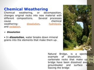
- 45. Chemical Weathering Chemical weathering, or decomposition, changes original rocks into new material with different compositions. Several processes cause chemical weathering: dissolution, hydrolysis, and oxidation. Dissolution • In dissolution, water breaks down mineral grains into the elements that make them up. Natural Bridge, is a spectacular example of dissolution. The carbonate rocks that make up the bridge have been dissolved away by groundwater and surface water, leaving the bridge
- 46. Hydrolysis • In hydrolysis, elements in water (hydrogen and oxygen) replace elements in the original material, creating a new substance. Granite gneiss is converting to clay by hydrolysis This deeply weathered granite gneiss has been weathered by hydrolysis.
- 47. Oxidation • In oxidation, oxygen reacts with the original material to create new material. Iron minerals are especially likely to be oxidized. • Oxidation is characterized by red, orange, and yellow stains that look like rust. These Highland County shales show evidence of oxidation.
- 48. Oxidati on
- 49. The action of plants and animals leads to breaking of rocks. Roots causing disintegration of rocks. The roots of the trees penetrate into the cracks of the rocks.
- 51. Burrowing animals Quarrying By human excreta
- 52. Climate and Weathering Climate has an important effect on weathering. The same rock in a different climate weathers very differently. Humid and Warm • In humid and warm regions, chemical weathering is the dominant type of weathering. Landforms tend to be more rounded and soils tend to be thicker. Virginia has a warm, humid climate. Old Rag Mountain, is typical of landforms in humid areas. Note the gentle, rounded slopes and abundance of vegetation.
- 53. Dry and Cold • In dry and cold regions, physical weathering is the dominant type of weathering. Landforms tend to be sharp and angular and soils tend to be thin. Sharp, angular landforms such as these are typical of landforms in desert regions.
- 54. Soil Development Soils result from weathering of rocks. Soils can be grouped according to their origins: residual soil, colluvial soil, and alluvial soil. Residual Soil • Residual soil is soil formed from the weathering of the bedrock below. The texture and composition of residual soil reflects the parent rock. Residual soil forms on the bedro This deeply weathered residual soil (above photo) formed on mafic igneous rocks. Erosion by running water causes the “badlands” topography.
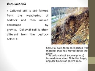
- 55. Colluvial Soil • Colluvial soil is soil formed from the weathering of bedrock and then moved downslope by gravity. Colluvial soil is often different from the bedrock below it. Colluvial soils form on hillsides from material that has moved down the slope This colluvial soil (above photo) formed on a steep Note the large, angular blocks of parent rock.
- 56. Alluvial Soil • Alluvial soil is soil formed on stream deposits. It is nearly always different from the bedrock below it. Alluvial soils are made up of grains that have been transported and deposited by stream processes.
- 57. Landforms of Weathering • Regolith and Soil Most landforms to some extent show the effects of weathering. On the bedrock surface of these landscapes are the accumulations of the products of weathering. Within these accumulations are materials displaying various degrees of physical, chemical, and biological alteration. These materials range in size from large boulders to clay sized particles less than 0.004 millimeters in diameter. Geomorphologists refer to these accumulations as regolith. Regolith can be further altered by climate, organisms, and topography over time to create soil. Soil is the most obvious landform of weathering.
- 58. Limestone Landforms Among the most interesting and most beautiful landforms of weathering are those which develop in regions of limestone bedrock. These landscapes are commonly called karst. In karst landscapes weathering is concentrated along joints and bedding planes of the limestone producing a number of different sculptured features from the effects of solution. Depressions of all sizes and shapes pit the landscape surface and are the most obvious features associated with karst. Beneath the surface, solution results in the formation of caves, springs, underground water channels, and deposits from evaporation. Periglacial Landforms Unique weathering landforms are also found in polar and sub-polar regions. In these regions, physical weathering processes are dominant, with active freeze-thaw and frost-shattering being the most active. Associated with these weathering processes are a number of unique surface features that develop only in periglacial environments. Collectively known as patterned ground, these surface features resemble circles, polygons, nets, steps, and stripes. The outlines of all of these features consist of elevated accumulations of coarse regolith fragments. Scientists believe that these outlines result from the systematic sorting of particles of a wide range of texture sizes by freeze-thaw action. The sorting causes larger fragments to move vertically upward and horizontally outward. Horizontal movement stops when one feature encounters another, linking the perimeter of two or more features. The linking of many adjacent features creates net-like patterns.
- 59. Engineering importance of rock weathering: As engineer is directly or indirectly interested in rock weathering specially when he has to select a suitable quarry for the extraction of stones for structural and decorative purposes. The process of weathering always causes a lose in the strength of the rocks or soil. For the construction engineer it is always necessary to see that: To what extent the area under consideration for a proposed project has been affected by weathering and What may be possible effects of weathering processes typical of the area on the construction materials.
- 64. EARTH’S INTERNALSTRUCTUREANDCOMPOSITION The Earth is divided into three distinct layers. They are Crust, Mantle and Core. The Earth is about 6378 km in radius.
- 65. CRUST The outermost layer of the Earth is called the crust. It composes about 1/2% (0.005) of the Earth's total mass. The Crust is subdivided into Oceanic and Continental crusts. The Oceanic crust is the layer below the deep ocean basins. It is basaltic, made up predominantly of the rock basalt, dense (density > = 3.0 to 3.2 g/cm3), thin (10-15 km) and young (<< 250My). The Continental crust is the layer that forms the continents. It is granitic, made up predominantly of the rock granite, plus overlying sediments), light (density = 2.7 g/cm3), thick (40-60km) and old (250 - 3700 My).
- 67. MOHODISCONTINUITY • The lower boundary of the crust, both oceanic and continental, is a seismic discontinuity (reflector) called the Moho. • LITHOSPHERE • The crust (both oceanic and continental) together with the uppermost mantle behave as rigid, brittle, rocky plates and together form the lithosphere. The lithosphere is generally considered to be the upper 100 km of the Earth. • Note that the lithosphere includes the crust, but also includes part of the upper mantle.
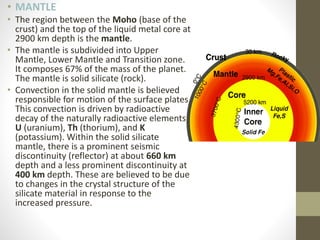
- 68. • MANTLE • The region between the Moho (base of the crust) and the top of the liquid metal core at 2900 km depth is the mantle. • The mantle is subdivided into Upper Mantle, Lower Mantle and Transition zone. It composes 67% of the mass of the planet. The mantle is solid silicate (rock). • Convection in the solid mantle is believed responsible for motion of the surface plates. This convection is driven by radioactive decay of the naturally radioactive elements, U (uranium), Th (thorium), and K (potassium). Within the solid silicate mantle, there is a prominent seismic discontinuity (reflector) at about 660 km depth and a less prominent discontinuity at 400 km depth. These are believed to be due to changes in the crystal structure of the silicate material in response to the increased pressure.
- 69. GUTENBERG DISCONTINUITY Gutenberg discontinuity separates mantle from core, where change from silicates and oxides to a molten iron, nickel, silicon, phosphorous liquid. CORE The core is the region below the mantle (2900-6370 km depth). The core is subdivided into the outer liquid core and the inner solid core. It is made of metal, [Fe (iron), Ni (nickel), plus a small amount of a lighter element, probably Si. The outer core is liquid (molten) down to a depth of 5200 km below the surface, and is solid metal below. Convection in the metal core is believed responsible for the magnetic field.
- 70. INTERNAL STRUCTURE OF EARTH • Layers of the Earth • To understand the details of plate tectonics, one must first understand the layers of the Earth. Unfortunately, humankind has insufficient first-hand information regarding what is below; most of what we know is pieced together from models, seismic waves, and assumptions based on meteorite material. The Earth can be divided into layers based on chemical composition and physical characteristics.
- 72. • Chemical Layers The Earth has three main divisions based on its chemical composition, chemical makeup. Indeed, there are countless variations in composition throughout the Earth, but only two significant changes occur, leading to three distinct chemical layers.
- 73. • Crust • The crust is the outermost chemical layer, and the layer humans currently reside on. The crust has two types: continental crust, which is relatively low density and has a composition similar to granite, and oceanic crust, which is relatively high density (especially when it is cold and old) and has a composition similar to basalt. In the lower part of the crust, rocks start to be more ductile and less brittle because of added heat. Earthquakes, therefore, generally occur in the upper crust. • At the base of the crust is a substantial change in seismic velocity called the Mohorovičić Discontinuity, or Moho for short, discovered by Andrija Mohorovičić (pronounced mo-ho-ro-vee-cheech) in 1909 by studying earthquake wave paths in his native Croatia. It is caused by the dramatic change in composition between the mantle and the crust. Underneath the oceans, the Moho is about 5 km down. Under continents, the average is about 30-40 km, except near a sizeable mountain-building event, known as an orogeny, where that thickness is roughly doubled.
- 74. • Mantle • The mantle is the layer below the crust and above the core. It is the most substantial layer by volume, extending from the base of the crust to a depth of about 2900 km. Most of what we know about the mantle comes from seismic waves, though some direct information can be gathered from parts of the ocean floor brought to the surface, known as ophiolites. Also carried within magma are xenoliths, small chunks of lower rock carried to the surface by eruptions. These xenoliths are made of the rock peridotite, which is ultramafic on the scale of igneous rocks. We assume the majority of the mantle is made of peridotite.
- 75. • Core • The core of the Earth, which has both liquid and solid components, is made mainly of iron, nickel, and oxygen. It was first discovered in 1906 by looking into seismic data. It took the union of modeling, astronomical insight, and seismic data to arrive at the idea that the core is primarily metallic iron. Meteorites contain much more iron than typical surface rocks. If meteoric material is what made the Earth, the core would have formed as dense material (including iron and nickel) sank to the center of the Earth via its weight as the planet formed, heating the Earth intensely.
- 76. • Physical Layers • The Earth can also be broken down into five distinct physical layers based on how each layer responds to stress. While there is some overlap in the chemical and physical designations of layers, precisely the core-mantle boundary, there are significant differences between the two systems. (2 Plate Tectonics – An Introduction to Geology, n.d.)
- 78. • Lithosphere • The lithosphere, with ‘litho’ meaning rock, is the outermost physical layer of the Earth. Including the crust, it has both oceanic and continental components. Oceanic lithosphere, ranging from a thickness of zero (at the forming of new plates on the mid-ocean ridge) to 140 km, is thin and rigid. The continental lithosphere is more plastic (especially with depth) and thicker, from 40 to 280 km thick. Most importantly, the lithosphere is not continuous. Instead, it is broken into several segments that geologists call plates. A plate boundary is where two plates meet and move relative to each other. It is at and near plate boundaries where plate tectonics are seen, including mountain building, earthquakes, and volcanism.
- 79. • Asthenosphere • With ‘astheno’ meaning weak, the asthenosphere is the layer below the lithosphere. The most distinctive property of the asthenosphere is movement. While still solid, over geologic time scales, it will flow and move because it is mechanically weak. In this layer, partly driven by convection of intense interior heat, movement allows the lithospheric plates to move. Since certain types of seismic waves pass through the asthenosphere, we know that it is solid, at least at the short time scales of the passage of seismic waves. The depth and occurrence of the asthenosphere are dependent on heat and can be very shallow at mid-ocean ridges and very deep in plate interiors and beneath mountains.
- 80. • Mesosphere • The mesosphere, or lower mantle as it is sometimes called, is more rigid and immobile than the asthenosphere, though still hot. This can be attributed to increased pressure with depth. Between approximately 410 and 660 km depth, the mantle is in a state of transition, as minerals with the same composition are changed to various forms, dictated by increasing pressure conditions. Changes in seismic velocity show this, and this zone also can be a physical barrier to movement. Below this zone, the mantle is uniform and homogeneous, as no significant changes occur until the core is reached.
- 81. The outer core is the only liquid layer found within Earth. It starts at 2,890 km (1,795 mi) depth and extends to 5,150 km (3,200 mi). Inge Lehmann, a Danish geophysicist, in 1936, was the first to prove that there was an inner core that was solid within the liquid outer core based on analyzing seismic data. The solid inner core is about 1,220 km (758 mi) thick, and the outer core is about 2,300 km (1,429 mi) thick. It seems like a contradiction that the hottest part of the Earth is substantial, as hot temperatures usually lead to melting or boiling. The solid inner core can be explained by understanding that the immense pressure inhibits melting, though as the Earth cools by heat flowing outward, the inner core grows over time. As the liquid iron and nickel in the outer core moves and convects, it becomes the most likely source for Earth’s magnetic field. This is critically important to maintaining the atmosphere and conditions on Earth that make it favorable to life. Loss of outer core convection and the Earth’s magnetic field could strip the atmosphere of most of the gases essential to life and dry out the planet, much like what has happened to Mars.
- 82. Structure of Earth’s Crust The fundamental unifying principle of geology and the rock cycle is the theory of Plate Tectonics. Plate tectonics describes how the layers of the Earth move relative to each other. Specifically, the outer layer is divided into tectonic or lithospheric plates. As the tectonic plates float on a mobile layer beneath called the asthenosphere, they collide, slide past each other, and split apart. As a result, significant landforms are created at these plate boundaries, and rocks making up the tectonic plates move through the rock cycle.
- 83. Continents The oldest continental rocks are billions of years old, so the continents have had much time to happen to them. Constructive forces cause physical features on Earth’s surface known as landforms to grow. Crustal deformation – when crust compresses, pulls apart, or slides past other crust – results in hills, valleys, and other landforms. Mountains rise when continents collide when one slab of ocean crust plunges beneath another or a slab of continental crust to create a chain of volcanoes. Sediments are deposited to form landforms, such as deltas. Volcanic eruptions can also be destructive forces that blow landforms apart. The destructive forces of weathering and erosion modify landforms. Water, wind, ice, and gravity are fundamental forces of erosion.
- 84. Oceanic Basins The ocean basins are all younger than 180 million years. Although the ocean basins begin where the ocean meets the land, the continent extends downward to the seafloor, making the continental margin of continental crust. The ocean floor itself is not flat. The most distinctive feature is the mountain range that runs through much of the ocean basin, known as the mid-ocean ridge. The ocean trenches are the deepest places of the ocean, many of which are found around the edge of the Pacific Ocean. Chains of volcanoes are also found in the center of the oceans, such as around Hawaii. Finally, flat plains are located on the ocean floor with their features covered by mud.
- 88. Evidencesinsupportofcontinentaldrift • The evidences that support the hypothesis of continental drift include the fit of the shorelines of continents, • the appearance of the same rock sequences and mountain ranges of the same age on continents now widely separated, the matching of the glacial deposits and palaeoclimatic zones, • and the similarities of many extinct plant and animal groups whose fossil remains are found today on widely separated continents.
- 89. Plate tectonics
- 90. • In geologic terms, a plate is a large, rigid slab of solid rock. The word tectonics comes from the Greek root "to build." The term plate tectonics refers to how the Earth's surface is built of plates. • The theory of plate tectonics states that the Earth's outermost layer is fragmented into a dozen or more large and small plates that are moving relative to one other as they ride atop hotter, more mobile material. • Plate tectonics :- The theory of plate tectonics states that the Earth's lithosphere consists of large, rigid plates that move horizontally in response to the flow of the asthenosphere beneath them, and that interactions among the plates at their borders cause major geologic activity, including the creation of oceans, continents, mountains, volcanoes, and earthquakes.
- 91. Plate tectonics
- 92. • SEVEN LARGER AND SEVERAL SMALLER PLATES • The largest plates include the Pacific plate, the North American plate, the south American plate, the Eurasian plate, the Antarctic plate, and the African plate, the European plate • The Pacific plate is the largest plate at nearly 14,000 km wide. • Smaller plates include the Cocos plate, the Nazca plate, the Caribbean plate, and the Gorda plate. • The Cocos plate is 2000 km wide.
- 93. Work of wind
- 94. wind Wind as a Geological Agent Effective in performing geologic work under certain circumstances. Most effective when loose, dry and fined grained sediment, is exposed at the ground surface. Particles larger than fine sand, are normally too big to be picked up and transported by the wind’s energy. Wet sedimentary particles - tend to bind together, inhibiting the lifting potential of the wind. Most effective in arid and semiarid regions.
- 95. Ventifacts are any bedrock surface or stone that has been abraded or shaped by wind- blown sediment in a process similar to sand blasting. Wind-abraded rocks are called dreikanters from a South African word meaning "three corners."
- 96. Work of rivers
- 97. STREAM :- any body of flowing water confined within a channel, regardless of size. Flows down hill through local (TOPOGRAPHIC LOWS) DRAINAGE BASIN :- The region from which a stream draws water is its drainage basin. SIZE OF A STREAM AT ANY POINT is related in part to the size (area) of the drainage basin upstream from that point. Its size is influenced by CLIMATE – amount of precipitation and evaporation VEGETATION – lack of it and UNDERLYING GEOLOGY
- 98. Work of rivers STREAM :- any body of flowing water confined within a channel, regardless of size. Flows down hill through local (TOPOGRAPHIC LOWS) DRAINAGE BASIN :- The region from which a stream draws water is its drainage basin. SIZE OF A STREAM AT ANY POINT is related in part to the size (area) of the drainage basin upstream from that point. Its size is influenced by CLIMATE – amount of precipitation and evaporation VEGETATION – lack of it and UNDERLYING GEOLOGY
- 103. • • LOAD :- The total quantity of material that a stream transports. • Bed load • Dissolved load • Suspended load - saltation • BED LOAD • Heavier debris – rolled or pushed along the bottom of the stream bed. • SUSPENDED LOAD (Muddy appearance to stream water) • Material that is light or fine enough to be moved along suspended in the stream, supported by the flowing water. • SALTATION • Intermediate sized material carried in short hops along the stream bed by saltation process. • DISSOLVED LOAD • Substances – completely dissolved in the water. •
- 104. Work of sea
- 106. • Marine abrasion involves the rubbing and grinding action of the sea water on the rocks of the shore • Sand particles and other small fragments that are hurled up again and again . • Continued marine erosion results in considerable or even total modification of the original shore line • The strength of the sea waves, currents and their magnitude. • The lithology • The sea ward slope • The height of the shore line • The depth and chemical composition of the water • The original profile of the shore line
- 111. Petroleum Geology 111 1. EARTHQUAKE It is vibration of the Earth's by shock waves generated by energy released from rocks rupturing under stress Causes of earthquakes: Faults, landslides, rockslides, movement of magma or gases, volcanic activities among others Focus: Exact location of the earthquake below the surface of the Earth Epicenter: The position on the surface of the Earth directly above the focus Seismic waves: waves which travel within the Earth P (primary) wave - moves in a straight line path with alternating compression and expansion S (secondary) wave - moves in a sinusoidal motion along its path of movement
- 112. Petroleum Geology 112 P-Wave Propagation Compressional waves Series of contractions and relaxations Fastest, ~5 km/sec (depends on rock type) Travel through solid, liquid and gas S-Wave Propagation Shear waves: motion is right angles to direction of wave Half speed of P waves Travel only through solid
- 113. Petroleum Geology 113 Seismographs is the machine that detects seismic waves.
- 114. Petroleum Geology 114 Modified MercalliScale Measuresearthquakeintensity. Describesdamagetostructures.ItrangesfromI(feltbyonlya few)toXII(totaldestruction). RichterScale Measuresearthquakemagnitude. Determinedbymeasuringtheamplitudeofthelargestwaveson theseismogram. Itislogarithmicscale,whereeachnumberon theRichterScaleistentimesgreaterinwaveamplitude(each numberontheRichterScaleinvolvesanenergyreleaseabout32 timesasgreat). Measuring Earthquakes Several different scales exist to measure earthquakes
- 116. Petroleum Geology 116 Earthquake of different magnitudes all the time
- 118. • AN EARTHQUAKE • Is a trembling of the ground caused, by sudden release of energy in underground rocks. • Most earthquakes occur • Where rocks are subjected to the stress associated with tectonic plate movement – that is, near plate boundaries, under such stress, rocks may deform elastically and accumulate STRAIN ENERGY, which builds until the rocks either shift suddenly along preexisting faults or rupture to create new faults, causing earthquakes.
- 119. EARTHQUAKE BELTS IN INDIA Zone of maximum intensity (0.1-0.15) Assam, northern Bihar, strips of Uttar Pradesh, Uttaranchal, U.P, Delhi, Haryana, Punjab, Himachal Pradesh, Jammu & Kashmir. Intermediate intensity (0.05) Southern flat lands of Haryana Punjab, U.P, Rajasthan, M.P Bihar Bengal ,Orrissa, Gujarat, and Maharashtra Minimum intensity (0.01) The triangular parts of India surrounded on the sides of Arabian sea, bay of Bengal and the Indian ocean.
- 120. GROUND WATER
- 123. • Groundwater: water found underground, in the pore spaces of earth materials • * It moves: it’s a liquid, so it flows (slowly) from high elevations toward low areas * Rivers like it: many rivers and streams are fed by groundwater from below. In arid regions, river water leaks out and down into the groundwater. • * People like it: ~ 40% of our water resources are groundwater supplies
- 124. A Few Definitions: * Groundwater: underground water found saturating (filling) the pores of earth materials. * Usually refers to fresh water: saline groundwater is called “brine”, and is usually found deeper. * Zone of Aeration: above the water table, pores are only partially filled; water plus air * Zone of Saturation: below water table, pores filled with groundwater * Water table: boundary between unsaturated and saturated zones * Perched water table: a shallow, local water table located above the regional water table. Porosity: Informal: holes in the rock where the water stays * Formal: ratio of pore space to total volume in rock or sediment (expressed as %) the more porous a material is, the more water it can hold * Limestones: 1-20% * Sandstones: 5-25% * Shales: 20-45%