Basics to gis concepts unit i
•
19 likes•5,968 views

This document provides an overview of basic concepts in geographic information systems (GIS). It defines GIS as a system for capturing, storing, integrating, analyzing and displaying spatially-referenced data. Key components of GIS include data input, storage, management, analysis and output. GIS handles spatial data referenced by location and allows analysis of relationships based on spatial proximity. GIS has a wide range of applications in fields like government, agriculture, business, environment and research.
Report
Share


Basics to gis concepts unit i
- 1. Basic Concepts of GIS K B Bindu Assistant Professor, Department of Geography, H. M. College, Manjeri UNIT I
- 2. GIS: a formal definition “A system for capturing, storing, checking, integrating, manipulating, analysing and displaying data which are spatially referenced to the Earth. This is normally considered to involve a spatially referenced computer database and appropriate applications software” Chorley Report, 1987
- 3. What is a GIS ? • A technology • An information handling strategy - to improve overall decision making An organized collection of computer hardware, software, geographic data and personnel
- 4. GIS comprises of: Data input, Storage, Management, Analysis and Output StoreStoreStoreStore AnalyzeAnalyzeAnalyzeAnalyze ModelModelModelModel DisplayDisplayDisplayDisplay CaptureCaptureCaptureCapture GIS is designed to efficiently to GIS Data
- 5. Why is GIS unique? • GIS handles SPATIAL information Information referenced by its location in space • GIS makes connections between activities based on spatial proximity • Multidisciplinary, Integrated and Holistic
- 6. Measuring and Integrating the Parts... Social Factors Biodiversity Engineering Land Use Environmental Considerations … Means Seeing the Whole
- 7. Watersheds Communities Neighborhoods Ecosystems Context and ContentContext and Content Patterns Linkages Trends Seeing the Whole Managing Places
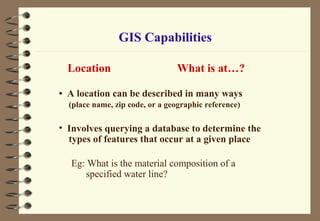
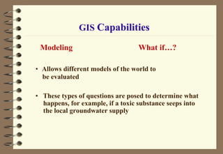
- 8. A good GIS system should be able to answer the following questions • Location What is at ? • Condition Where is it ? • Trend What has changed since ? • Routing Which is the best way ? • Pattern What spatial patterns exist ? • Modeling What if ? GIS Capabilities
- 9. Location What is at…? • A location can be described in many ways (place name, zip code, or a geographic reference) • Involves querying a database to determine the types of features that occur at a given place Eg: What is the material composition of a specified water line? GIS Capabilities
- 10. Condition Where is it…? • Involves finding the location of sites which have certain characteristics • Instead of identifying what exists at a given location, you want to find a location where certain conditions are satisfied Eg: If you are looking for an unforested section of land at least 2,000 square meters in size, within 100 meters of a road, and with soils suitable for supporting building GIS Capabilities
- 11. GIS Capabilities Trend What has changed…? • Involves monitoring how things change over time
- 12. GIS Capabilities Pattern What is the pattern…? • Allows to describe and compare the distribution of phenomena and understand the processes which account for their distribution Eg: You may ask this question to determine whether cancer is a major cause of death among residents next to a nuclear power plant
- 13. GIS Capabilities Modeling What if…? • Allows different models of the world to be evaluated • These types of questions are posed to determine what happens, for example, if a toxic substance seeps into the local groundwater supply
- 14. The benefits of GIS include: Better information management Higher quality analysis Ability to carry out ‘what if?’ scenarios Improve project efficiency
- 15. Principal Functions of GIS Data Acquisition Database Management and Update Analysis Presenting Results
- 16. Data Sources National Mapping AgenciesNational Mapping Agencies SatelliteSatellite Ortho photographyOrtho photography LocalLocal Created by usersCreated by users
- 17. Data Acquisition Maps Field Data Digital Product Tabular Data Reports Discussion K E_ID DST C ONST R 96 R 96LDF_PR96UDF _PR01 R 01LDF _PR 01UD F_PR 96LE R96B JP VR 96C R 0 0 0 0 1 kas er god manjees w ar am udf c pm iuml UD F c pm iuml 0 0 0 2 kas er god k as ergod udf indp iuml UD F c pm iuml 0 0 0 3 kas er god uduma l df c pm c on- i LDF c pm c on- i 0 0 0 0 kas er god hos durg l df c pm c on- i LDF c pi c on- i 0 0 0 0 kas er god t rik aripur l df c pm c on- i LDF c pm c on- i 0 0 0 0 kannur ir ik kur udf k cj c on- i UD F k c j c on- i 0 0 0 0 kannur pay y annur l df c pm c on- i LDF c pm c on- i 0 0 0 0 kannur t halippar amb l df c pm c on- i LDF c pm c on- i 0 0 0 0 kannur per avur l df c on- s c on- i UD F nc p c on- i 0 0 0 0 kannur azhik od l df c pm c mp LDF c pm c mp 0 0 0 0 kannur edak k ad l df c pm c on- i LDF c pm c on- i 0 0 0 0 vay anad vay anad- n udf c pm c on- i UD F c pm c on- i 7965 7435 5428 0 kannur k annur udf indp c on- i LDF inl c on- i 0 0 0 0 kannur k oot hupar amb l df c pm c on- i LDF c pm c on- i 0 0 0 0 kannur t halas sery l df c pm c on- i LDF c pm c on- i 0 0 0 0 vay anad s ul thanbethery l df c pm c on- i UD F indp c on- i 0 0 0 0 kannur per igalam l df jd iuml LDF jd- s iuml 14080 10306 5255 0 koz hi kod nadapur am l df c pi c on- i LDF c pi c on- i 0 0 0 0 mahi 0 0 0 0 vay anad k al pat ta udf jd c n- i UD F jd- s c on- i 0 0 0 0 koz hi kod vadak ara l df jd c on- i LDF jd- s c on- i 0 0 0 0 koz hi kod nadapur am l df c pi c on- i LDF c pi c on- i 14629 4757 1971 0 koz hi kod per ambra l df c pm k cm LDF c pm k c m 0 0 0 0 koz hi kod k oi landi l df c pm c on- i UD F c pm c on- i 0 0 0 0 mal apuram t hir uaambadi udf indp iuml UD F 0 0 0 0 koz hi kod k oduvally udf jd iuml UD F 94 9596 5094 0 koz hi kod bal us s er y l df c on- s c on- i LDF 0 0 0 0 mal apuram nilambur udf indp c on- i UD F 0 0 0 0 mal apuram vandur l df c pm c on- i UD F c pm 0 0 0 0 koz hi kod k unnamangalam l df c pm iuml UD F 0 0 0 0 koz hi kod k al ic ut -1 l df c pm c on- i UD F 0 0 0 0 mal apuram manjery udf jd iuml UD F 0 0 0 0 koz hi kod k al ic ut -2 l df c pm iuml UD F 0 0 0 0 koz hi kod beppur l df c pm iuml LDF 0 0 0 0 mal apuram k ondott y udf jd iuml UD F 0 0 0 0 palak ad mannar kad l df c pi iuml UD F 0 0 0 0 mal apuram t hir urr angadi udf indp iuml UD F 0 0 0 0 mal apuram malappuram udf indp iuml UD F 0 0 0 0 mal apuram t hanur udf indp iuml UD F 0 0 0 0 palak ad s rek ris hnapuram l df c pm c on- i UD F 4017 6098 2087 0 mal apuram t hir oor udf indp iuml UD F 0 0 0 0 palak ad malambuz ha l df c pm c on- i LDF 0 0 0 0 palak ad pat t am bi l df c pi c on- i UD F 0 0 0 0 palak ad ott apalam l df c on- s c on- i LDF 7358 10856 4443 0 palak ad ott apalam l df c pm c on- i UD F 4017 6098 2087 0 palak ad pal ak ad l df c pm c on- i UD F 0 0 0 0 palak ad c hi tt ur udf jd c on- i UD F 0 0 0 0 mal apuram ponnani l df c pm c on- i UD F 0 0 0 0 thris s ur c helak ar a l df c pm c on- i LDF 0 0 0 0 palak ad k uz halmannam l df c pm c on- i LDF 0 0 0 0 palak ad t hr it hala l df c pm c on- m LDF 0 0 0 0 thris s ur gur uvayur & nat l df c pi c on- i UD F 0 0 0 0 palak ad k ol lank od udf c pm c on- i UD F 0 0 0 0 thris s ur vadak k anc her i udf k cj c on- i UD F 0 0 0 0 thris s ur k unnamkulam l df c pm c on- i UD F 0 0 0 Remote Sensing
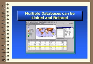
- 18. GIS Data The GIS Data - a collection of Geographic Features Spatial data (information about location) Attribute data (descriptive data about particular feature) Spatial data Attribute data GIS+ Linking of this spatial data & attribute data gives a full picture of a feature in GIS
- 19. Spatial Data: Vector format Point - a pair of x and y coordinates Line - a sequence of points Polygon - a closed set of lines
- 20. Raster Data Point Line Polygon Vector Raster Raster data are described by a cell grid, one value per cell Zone of cells
- 27. GIS Analysis • Overlay • Buffer Zones • Network Operations • Terrain Analysis • Spatial Analysis & Modeling • Geostatistical Operations
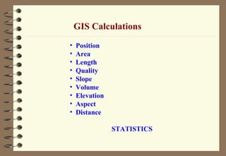
- 28. • Position • Area • Length • Quality • Slope • Volume • Elevation • Aspect • Distance STATISTICS GIS Calculations
- 37. • Disaster Management • Crime Analysis • Participatory Development • Town and Regional Planning • Planning for Efficient Distribution of Water Supply, Sewerage System, Power Supply • Tracking and Controlling Infectious Diseases • Planning and Scheduling of Public Transport System …many more GIS Applications Government Sector
- 38. • Spatial Water Budget Model • Effects of Ground water • Productivity Analysis • Suitability Analysis for Crops • Planning/Participatory • Management for Agriculture • Setting of Industries • Feasibility Analysis for Industries • Transportation Cost Analysis of Products …many more GIS Applications Agriculture & Industry
- 39. GIS Applications Business & Marketing • Market Analysis for Products • Optimal Routing for Distribution of Products • Location Analysis for Markets • Planning for Effective and Efficient • Distribution of Perishable Goods • Locating Potential Customers • Widening Horizons for Communication Systems …many more
- 40. GIS Applications Environment & Management • Environmental Impact Assessment • Sustainable Management and • Utilization of Resources • Conservation of Ecologically Fragile Zones • River Basin Management • Development of Stream Water Systems • Hazardous Waste Management • Sustainable Development • Energy Distribution Management …many more
- 41. GIS Applications Research & Development • Submergence Analysis for Dams • Sub-surface Modeling of Oceans • Identification of Flood Prone • Areas, Landslide Prone Areas • Ground Water Modeling • Air Pollution Dispersion Modeling • Modeling of Forest Fire Spread • Hurricanes, Sediment Transport • Wave Propagation Modeling …many more
- 42. GIS Software Used Worldwide GIS IMAGE PROCESSING ESRI ArcGIS ESRI ArcInfo workstation ESRI Arcview AutoCAD MAP2000 Mapinfo Geomedia Professional Microstation Surfer Erdas Imagine Intergraph MGE
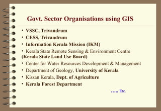
- 43. Govt. Sector Organisations using GIS • VSSC, Trivandrum • CESS, Trivandrum • Information Kerala Mission (IKM) • Kerala State Remote Sensing & Environment Centre (Kerala State Land Use Board) • Center for Water Resources Development & Management • Department of Geology, University of Kerala • Kissan Kerala, Dept. of Agriculture • Kerala Forest Department ….. Etc.
- 44. Private Sector Organisations using GIS More than 240 companies / organizations • ESRI India, New Delhi • Geotrans Technologies Pvt Ltd, Trivandrum • IES Geospatial Systems India Pvt. Ltd, Trivandrum • Geographis (India) Ltd, Ahmedabad • Map’s Geographical Infosystems Pvt. Ltd, Pune • PCS Infomatics, Hyderabad • TATA Consultancy Services, New Delhi • RMSI Pvt Ltd, Hyderabad • Rolta India Limited, New Delhi • Speck Systems Limited, Hyderabad …. Etc.
- 45. GIS Education / Training in India • Allahabad University, Department of Geography • Anna University, Department of Geology • Banaras Hindu University, Faculty of Science • Burdwan University, Geography • Centre for Environmental Planning and Technology (CEPT) , Ahmedabad • Centre for Environment and Development (CED), Trivandrum • GIS Institute, Noida • Himachal Pradesh University, Department Of Geography • IIT, Mumbai, Centre of studies in Resources Engineering & Department of Earth Sciences • Indian Institute of Remote Sensing, Dehradun • Jadavpur University, The Department of Geology • Madurai Kamaraj University, Geography • Maharaja Sayajirao University of Baroda, Geography • NRSA, Hyderabad • Pune University, Department of Environmental Science & Department Of Geography • School of Planning, Centre for Environmental Planning & Technology, Delhi University • University of Madras, Department of Geography • University of Pune, Department of Space Sciences
Editor's Notes
- The history of using computers for mapping and spatial analysis shows that there have been parallel developments in automated data capture, data analysis and presentation in several broadly related fields. These fields are cadastral and topographical mapping, thematic cartography, civil engineering, geography ,mathematical studies of spatial cartography, utility network and remote sensing and image analysis. Military applications have overlapped and even dominated several of these monodisciplinary fields. Consequently there has been much duplication of efforts and multiplication of discipline specific jargon for different applications in different lands. This multiplicity effort from several fields is now resulting in the possibility of linking many kinds of spatial data processing together into general –purpose Geographical Information Systems.
- Essentially all these fields are attempting the same sort of operations – namely to develop a powerful set of tools for collecting, storing, retrieving, transforming and displaying spatial data from the real world for a particular set of purposes. These set of tools together constitute a geographical information system.
- GIS is an organized collection of hardware, software, geographic data and personnel designed to efficiently capture, store, update, manipulate and display all forms of geographically referenced information. In other words GIS is a system for capturing, storing, checking, integrating, manipulating, analysing and displaying data which are spatially referenced to the Earth. This is normally considered to involve a spatially referenced computer database and appropriate applications software.
- GIS is a special – purpose digital database in which a common spatial coordinate system is the primary means of reference. Comprehensive GIS require a means of data input,storage,transformation and data reporting in the form of various output. GIS is desgined in such a way that it can effeciently capture data from source, can store in database, can perform analysis and modeling including spatial statistics and can clearly display the output in the form of maps, reports and plans.
- GIS are related to other database applications, but with an important difference. All information in GIS is linked to a spatial reference. Other database may contain locational information (such as street address, zip codes), but a GIS database uses geo – references as the primary means of storing and accessing information. GIS integrates technology. Whereas other technologies might be used only to analyze aerial photographs and satellite images to create statistical models, or to draft maps, thee capabilities are all offered within comprehensive GIS. The importance of GIS an integrating technology is also evident in its pedigree. The development of GIS has relied on innovations made in many different disciplines : Geography, Cartography, Photogrammetry, Remote sensing, surveying etc have all contributed. Indeed, these efforts indicates its interdisciplinary character and heritage.
- GIS with its array of functions, should be viewed as a process rather than as merely software or hardware. GIS for making decisions. The way data is entered, stored and analyzed within a GIS must mirror the way information will be used for a specific research or decision – making task. To see GIS as merely a software or hardware system is to miss the crucial role it can play in a comprehensive decision making process. Rather than being completely new, GIS have evolved by linking a number of discrete technologies into a whole that is greater than the sum of its parts. GIS has emerged as very powerful technologies because they allow geographers to integrate their data and methods in ways that support traditional forms of geographic analysis. With GIS it is possible to map, model, query and analyze large quantities of data all held together within a singal database.
- Geographical Information Systems can be applied in different context and content of study and analysis. An area can be interpreted as a whole by studying the pattern of distribution of various phenomena , their linkages and trends of changes. Apart from this GIS is also considered for systematic management of places. Places can differ in concern with their size and functionality. It can be a watersheds, communities, neighborhoods or an ecosystems, for all these GIS is an opted management system.
- Until very recently, most geographical information systems were set up for local applications, or for work on a limited project area. There are now strong indications that many users, particularly major government agencies are willing or have started to set up comprehensive countrywide systems. A good GIS system should be designed to answer these questions. Many of these questions are difficult to answer using conventional methods ( for example calculating the portion of different kinds of soil mapped requires either extensive work with planimeter or that map units drawn on the paper should be cut out and individually weighted. • A location can be described in many ways (place name, zip code, or a geographic reference) Instead of identifying what exists at a given location, you can find a location where certain conditions are satisfied Involves monitoring how things change over time Allows to describe and compare the distribution of phenomena and understand the processes which account for their distribution Allows different models of the world to be evaluated