Fishing Ground of Bay of Bengal
- 1. Fishing Ground of BOB By Mahabubur Rahman Lecturer, FIMS, NSTU
- 2. Fishing ground • Fishing ground is those area of a water body where fish concentration remain always significant • Generally fishing ground is divided into two ways- permanent fishing ground and temporary fishing ground
- 3. Bay of Bengal (BOB) • the largest bay in the world • located between latitudes 5°N and 22°N and longitudes 80°E and 100°E • area of about 21,72,000 km² and the average depth is 2,600m with a maximum depth of 5,258m • Fisheries production in the Bay of Bengal is six million tonnes per year, more than seven percent of the world’s catch • The Bay of Bengal is an area of high biodiversity, with a large number of endangered and vulnerable species
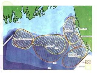
- 5. Fishing ground of BOB 1. South patches 2. South of south patches 3. Middle ground 4. Swatch of no ground
- 8. South patches located at 91.30ºE to 92.10ºE and 20.55ºS to 21.52ºS, total area of 3,662 sq km. Depth ranging from 10m to 100m, but 90% of the total area is less than 40m deep. Bottom sediment is sandy or slightly muddy sand. Nearest distance of the ground from Chittagong and Cox's Bazar is 40 km and 10 km respectively. Salinity in surface water ranges from 26% to 32% and 30% to 35% in bottom water. Water temperature varies between 20 and 28ºC.
- 9. South of south patches located at 91.30ºE to 92.20ºE and 20.15ºS 20.50ºS, area of 2,538 sq km. The nearest boundary of this area is 5 km from Teknaf. Depth ranges from 10m to 100m. Within this ground 75% of the area is more than 40m deep. Bottom is sandy or muddy sand. Surface salinity ranges from 18% to 34% and bottom water salinity from 28% to 38%. Water temperature ranges between 22ºC and 30ºC.
- 10. Middle ground located at 90.20ºE to 91.30ºE and 20.25ºS to 21.20ºS, total area of about 4,600 sq km. The nearest distance from Cox's Bazar is about 65 km. The depth of 70% of the total area is more than 40m. Bottom sediment is soft mud or muddy sand. Surface salinity ranges from 22% to 34% and bottom salinity 28% to 35%. Water temperature is between 26ºC and 28ºC.
- 11. Swatch of no Ground located at 89.35ºE to 90.10ºE and 20.55ºS to 21.55ºS about 30 km away from Dublarchar and 40 km from Sunarchar. Total area is about 3,800 sq km, of which 70% is more than 40m deep. Overall depth of the area ranges from 10m to 100m. Bottom sediment consists of muddy sand. Surface salinity is 28% to 34%, while the bottom salinity is 30% to 35%. Water temperature falls within 24ºC to 30ºC.
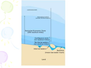
- 12. Exclusive Economic Zone (EEZ) • Generally a state’s EEZ extends to a distance of 200 nautical miles (370 km) out from its coast. • The exception to this rule occurs when EEZs would overlap; that is, state coastal baselines are less than 400 nautical miles (740 km) apart. • When an overlap occurs, it is up to the states to delineate the actual maritime boundary. • Generally, any point within an overlapping area defaults to the nearest state. • EEZ of Bangladesh spans 164,000 km2 and the shelf area covers roughly 66,440 km2
- 15. Fishing problems in the BOB 1. Problem associated with fishing crafts 2. Problem associated with fishing gears 3. Insufficient number of fishermen 4. Problem with detection of fishing ground 5. Lack of sufficient fish landing center 6. Poaching (fishing by foreigners) 7. Lack of government support 8. Problem associated with stock assessment 9. Environmental hazard


