Location via proxy:   [ UP ]  
[Report a bug]   [Manage cookies]                
SlideShare a Scribd company logo
GIS MAP PROJECTIONS
Muhammd Bilal Saleem
Session 2012-2014
M.Phil Geomatics
DESCRIPTION
 Two dimensional representation of the three dimensional Earth
 Systematic transformation of latitudes and longitudes to
parallels and meridians respectively
 An intriguing component of the coordinate system referencing
because it portrays high level of flexibility
 Transformation cause distortion in real world properties that
are:
1. Shape
2. Area
3. Distance
4. Direction
DEVELOPABLE PROJECTION SURFACES
 Determine specific method of physical projection
 Three kinds of developable projection surfaces:
1. Cone
2. Cylinder
3. Plane
 The name of the projections made from these surface are:
1. Conic Projection
2. Cylindrical Projection
3. Planar Projection
1. Conic Projection:
 Conic projection is fan shaped,
characterized by an upside down cone
over the sphere
 Conic projection are at an true scale
along a standard parallel/s between the
equator and a pole
 Conic projections are used for
midlatitude zones that have an east–
west orientation
 If equally space, distance preserve
 If distance between parallels increase
near border, shape preserve
 If distance towards north and south
pole decreases, area preserve
2. Cylindrical Projection:
 Cylindrical projection is a rectangular
grid representation, characterized by a
cylinder over a sphere
 Cylindrical projections are at an true
scale along a central meridian/s and
standard parallel/s near a equator
 Cylindrical projection mostly use for
tropical zones
 All cylindrical projections are
equidistant along central meridian/s
and standard parallel/s
3. Planar Projection:
 Planar projection is a circular
representation with a focus,
characterized by plane over a sphere
 Planar projection is also called
Azimuthal projection or Zenithal
projection
 Planar projections are true only at
their focus
 Planar projections mostly use for
polar zones
 Planar projection more better
describe circular regions than
rectangular regions
 Azimuthal Projection is further
divided into three different
projection on the basis of
projection focus:
1. Gnomonic/ Central projection
2. Stereographic Projection
3. Orthographic Projection
1) Gnomonic Projection:
Azimuthal projection in which
projection focus is at center of
the Earth
2) Stereographic Projection:
Azimuthal projection in which
projection focus is from pole
to pole
3) Orthographic Projection:
Azimuthal projection in which
projection focus is at infinity
LOCATION OF DEVELOPABLE PROJECTION
SURFACE
 There are two cases in which
developable projection
surface meet Earth:
1. Tangent:
DPS touches the Earth
One standard parallel/ One
Central meridian
2. Secant:
DPS cuts the Earth
Two standard parallels/ Two
central meridians
ASPECT OF DEVELOPABLE PROJECTION
SURFACE
 Projection aspect is the relative orientation
of the developable projection surface and
Earth with respect to the observer
 There are four kinds of projection aspects:
1. Normal
2. Transverse
3. Oblique
4. Polar
1) Normal Aspect:
 Oriented with polar axis
 Based on parallels
 Normal aspect is Equatorial aspect if
standard parallel is equator
 Normal aspect is Azimuthal aspect if
standard parallel touches poles
2) Transverse Aspect:
 Oriented perpendicular to polar axis
 Based on meridians
3) Oblique Aspect:
 Oriented at any angle with polar axis
 Based on central meridian and
standard parallel
 Use for geographical areas that are
centered along lines that are neither
parallel nor meridians
 Directed as northwest, northeast,
southwest and southeast
4) Polar Aspect:
 Oriented on focus as north or
south pole
 Based on straight meridians
with a concentric parallels
 Polar aspect only related to
planar projection or
Azimuthal projection or
Zenithal projection
PROJECTION CLASSIFICATIONS
 Classification defines a properties of the projected surfaces
 The names of the properties that preserves by the projected surfaces are
given below:
1. Shape: Conformal or Orthomorphic
2. Area: Equal Area or Equivalent
3. Distance: Equidistant
4. Direction: Azimuthal
1) Conformal Projection:
 Preserve shapes of small regions of the Earth that’s why use for medium
scale to large scale applications
 Shape preserve either angle preserve or scale preserve
 No projection preserve shape of larger regions
 Can preserve Direction by maintaining an angle between graticule lines
 Area of the region distorted for large scale applications
2) Equal Area or Equivalent:
 Preserve area of all regions of the Earth’s surface that’s why use for
small scale to large scale applications
 Area preserve when scale vary equally on both sided of the standard
parallel
 Area and shape cannot preserve simultaneously
 For small scale applications, Direction also distorted
3) Equidistant:
 Preserve distance between entire regions of the Earth that are at true
scale that’s why use for small scale to large scale applications
 Distance only preserve when scale preserve
 No projection is equidistant to and from all points on a map
4) Azimuthal:
 Preserve direction of all regions of the Earth that’s why use for medium
to large scale applications
 Direction preserve when angle preserve
 Azimuthal projection can be equal area, conformal or equidistant
Formation of Map Projections:
 DPS can exhibit more than one classification
 The conic projection, cylindrical projection and planar projection can be
combined with one or more of the projection classifications to control
the appearance and distortion for any particular application
 There are lot of projections that can made by this procedure. Some of
the projections will discussed
MERCATOR PROJECTION
 Cylindrical projection
 Normal aspect
 Equator/ Two latitudes symmetrical
around the equator
 Meridians are parallel to each other
and equally spaced
 Parallels are parallel but become
farther apart toward the poles
 Distance preserve along Equator or
Two latitudes
 Shape preserve accurately
 Direction preserve accurately along
graticule lines
 Area not preserved and increase
towards the top and bottom of the map
 Use in Standard sea navigation charts,
Wind direction, Air travel and Ocean
currents
 Application in Conformal world maps
CYLINDRICAL EQUAL AREA PROJECTION
 Cylindrical projection
 Equatorial aspect
 Tangent to the equator
 All meridians are equally spaced and
0.32 times the length of the equator
 Parallels are equally spaced and
farthest apart near the equator
 Poles are lines of length equal to the
equator
 Distance preserve along equator
 Shape not preserve because of scale
variation
 Direction not preserved but local angle
preserve along standard parallels
 Area preserve accurately
 Use for narrow areas extending along
the equatorial regions
UNIVERSAL TRANSVERSE MERCATOR
PROJECTION
 Cylindrical projection
 Transverse aspect
 Two parallel lines spaced from each
central meridian by 180 km
 Earth is divided into 60 zones that
are spanning 6⁰ of longitude form
84⁰N & 80⁰S with central meridian of
each zone and equator
 Distance preserve along each central
meridian
 Shape not preserve accurately
 Direction preserve for each zone
 Area preserved and minimal
distortion along the boundary of
zone
 Extent should be limited to 15⁰-20 ⁰
on both sides of the central meridian
 Many countries use local UTM
zones based on the official
geographic coordinate systems in use
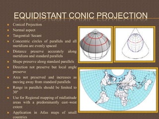
EQUIDISTANT CONIC PROJECTION
 Conical Projection
 Normal aspect
 Tangential/ Secant
 Concentric circles of parallels and all
meridians are evenly spaced
 Distance preserve accurately along
meridians and standard parallels
 Shape preserve along standard parallels
 Direction not preserve but local angle
preserve
 Area not preserved and increases as
moving away from standard parallels
 Range in parallels should be limited to
30°
 Use for Regional mapping of midlatitude
areas with a predominantly east–west
extent
 Application in Atlas maps of small
countries
ALBERS EQUAL AREA PROJECTION
 Conic projection
 Normal aspect
 Secant
 All meridians equally spaced
 Distance between concentric
parallels decreases toward poles
 Distance preserve for mid latitude
 Shape not preserve and distortion
increases between standard parallels
 Direction not preserve but local
angle preserve
 Area preserve accurately
 Used for small countries but not for
continents.
 Used for the conterminous United
States
LAMBERT CONFORMAL CONICAL
PROJECTION
 Conic projection
 Normal aspect
 Secant
 All meridians are equally spaced
 Distance between arc of parallels
increases near a border
 Distance preserve for mid latitude
 Shape preserve accurately
 Direction preserve accurately
 Area not preserved except small
regions near standard parallels
 All latitudinal range should not
exceed 35°
 Use for regions that have east-
west extension
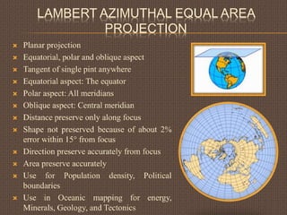
LAMBERT AZIMUTHAL EQUAL AREA
PROJECTION
 Planar projection
 Equatorial, polar and oblique aspect
 Tangent of single pint anywhere
 Equatorial aspect: The equator
 Polar aspect: All meridians
 Oblique aspect: Central meridian
 Distance preserve only along focus
 Shape not preserved because of about 2%
error within 15° from focus
 Direction preserve accurately from focus
 Area preserve accurately
 Use for Population density, Political
boundaries
 Use in Oceanic mapping for energy,
Minerals, Geology, and Tectonics
 Use for displaying entire continents
 Equatorial aspect: Africa, Southeast Asia, Australia,
the Caribbean, and Central America
 Polar aspect: Polar regions
 Oblique aspect: North America, Europe, and Asia
UNIVERSAL POLAR STEREOGRAPHIC
PROJECTION
 Stereographic projection
 Polar aspect
 Tangent at pole
 The focus is either a north pole or south pole
to 84° N and 80° S
 The latitude 81°06'52.3" N or 81°06'52.3" S
at true scale and all meridians
 Distance preserve only at focus and latitude
of 81°06'52.3" N or 81°06'52.3" S
 Shape preserve accurately
 Direction preserve accurately from focus
 Area not preserve and increases moving
away from focus
 Use for Conformal mapping of polar regions
 Use for mapping polar regions of the UTM
coordinate system
OTHERS PROJECTIONS
 The other projections which are not conceptually made and not
easily related to developable projection surface
 There are three kinds of these projections:
1. Modified projection
2. Pseudo projection
3. Compromise projection
1) Modified Projection:
 Modified form of conceptual projections to reduce distortion
 For example, the Space Oblique Mercator projection is a
modified form of Mercator projection, Aitoff is a modified
form of planar projection etc
2) Pseudo Projection:
 Have some Characteristics of another class of projection
 For example, the Sinusoidal is called a pseudo cylindrical
projection, Bonne is called pseudo conic projection and Werner
is called pseudo planar projection etc
3) Compromise Projection:
 Average or interrupted form of different projection
 For example, Goode's Homolosine projection is a combination
of the Mollweide and sinusoidal projections etc

More Related Content

GIS Map Projection

  • 1. GIS MAP PROJECTIONS Muhammd Bilal Saleem Session 2012-2014 M.Phil Geomatics
  • 2. DESCRIPTION  Two dimensional representation of the three dimensional Earth  Systematic transformation of latitudes and longitudes to parallels and meridians respectively  An intriguing component of the coordinate system referencing because it portrays high level of flexibility  Transformation cause distortion in real world properties that are: 1. Shape 2. Area 3. Distance 4. Direction
  • 3. DEVELOPABLE PROJECTION SURFACES  Determine specific method of physical projection  Three kinds of developable projection surfaces: 1. Cone 2. Cylinder 3. Plane  The name of the projections made from these surface are: 1. Conic Projection 2. Cylindrical Projection 3. Planar Projection
  • 4. 1. Conic Projection:  Conic projection is fan shaped, characterized by an upside down cone over the sphere  Conic projection are at an true scale along a standard parallel/s between the equator and a pole  Conic projections are used for midlatitude zones that have an east– west orientation  If equally space, distance preserve  If distance between parallels increase near border, shape preserve  If distance towards north and south pole decreases, area preserve
  • 5. 2. Cylindrical Projection:  Cylindrical projection is a rectangular grid representation, characterized by a cylinder over a sphere  Cylindrical projections are at an true scale along a central meridian/s and standard parallel/s near a equator  Cylindrical projection mostly use for tropical zones  All cylindrical projections are equidistant along central meridian/s and standard parallel/s
  • 6. 3. Planar Projection:  Planar projection is a circular representation with a focus, characterized by plane over a sphere  Planar projection is also called Azimuthal projection or Zenithal projection  Planar projections are true only at their focus  Planar projections mostly use for polar zones  Planar projection more better describe circular regions than rectangular regions
  • 7.  Azimuthal Projection is further divided into three different projection on the basis of projection focus: 1. Gnomonic/ Central projection 2. Stereographic Projection 3. Orthographic Projection 1) Gnomonic Projection: Azimuthal projection in which projection focus is at center of the Earth
  • 8. 2) Stereographic Projection: Azimuthal projection in which projection focus is from pole to pole 3) Orthographic Projection: Azimuthal projection in which projection focus is at infinity
  • 9. LOCATION OF DEVELOPABLE PROJECTION SURFACE  There are two cases in which developable projection surface meet Earth: 1. Tangent: DPS touches the Earth One standard parallel/ One Central meridian 2. Secant: DPS cuts the Earth Two standard parallels/ Two central meridians
  • 10. ASPECT OF DEVELOPABLE PROJECTION SURFACE  Projection aspect is the relative orientation of the developable projection surface and Earth with respect to the observer  There are four kinds of projection aspects: 1. Normal 2. Transverse 3. Oblique 4. Polar 1) Normal Aspect:  Oriented with polar axis  Based on parallels  Normal aspect is Equatorial aspect if standard parallel is equator  Normal aspect is Azimuthal aspect if standard parallel touches poles
  • 11. 2) Transverse Aspect:  Oriented perpendicular to polar axis  Based on meridians 3) Oblique Aspect:  Oriented at any angle with polar axis  Based on central meridian and standard parallel  Use for geographical areas that are centered along lines that are neither parallel nor meridians  Directed as northwest, northeast, southwest and southeast
  • 12. 4) Polar Aspect:  Oriented on focus as north or south pole  Based on straight meridians with a concentric parallels  Polar aspect only related to planar projection or Azimuthal projection or Zenithal projection
  • 13. PROJECTION CLASSIFICATIONS  Classification defines a properties of the projected surfaces  The names of the properties that preserves by the projected surfaces are given below: 1. Shape: Conformal or Orthomorphic 2. Area: Equal Area or Equivalent 3. Distance: Equidistant 4. Direction: Azimuthal 1) Conformal Projection:  Preserve shapes of small regions of the Earth that’s why use for medium scale to large scale applications  Shape preserve either angle preserve or scale preserve  No projection preserve shape of larger regions  Can preserve Direction by maintaining an angle between graticule lines  Area of the region distorted for large scale applications
  • 14. 2) Equal Area or Equivalent:  Preserve area of all regions of the Earth’s surface that’s why use for small scale to large scale applications  Area preserve when scale vary equally on both sided of the standard parallel  Area and shape cannot preserve simultaneously  For small scale applications, Direction also distorted 3) Equidistant:  Preserve distance between entire regions of the Earth that are at true scale that’s why use for small scale to large scale applications  Distance only preserve when scale preserve  No projection is equidistant to and from all points on a map
  • 15. 4) Azimuthal:  Preserve direction of all regions of the Earth that’s why use for medium to large scale applications  Direction preserve when angle preserve  Azimuthal projection can be equal area, conformal or equidistant Formation of Map Projections:  DPS can exhibit more than one classification  The conic projection, cylindrical projection and planar projection can be combined with one or more of the projection classifications to control the appearance and distortion for any particular application  There are lot of projections that can made by this procedure. Some of the projections will discussed
  • 16. MERCATOR PROJECTION  Cylindrical projection  Normal aspect  Equator/ Two latitudes symmetrical around the equator  Meridians are parallel to each other and equally spaced  Parallels are parallel but become farther apart toward the poles  Distance preserve along Equator or Two latitudes  Shape preserve accurately  Direction preserve accurately along graticule lines  Area not preserved and increase towards the top and bottom of the map  Use in Standard sea navigation charts, Wind direction, Air travel and Ocean currents  Application in Conformal world maps
  • 17. CYLINDRICAL EQUAL AREA PROJECTION  Cylindrical projection  Equatorial aspect  Tangent to the equator  All meridians are equally spaced and 0.32 times the length of the equator  Parallels are equally spaced and farthest apart near the equator  Poles are lines of length equal to the equator  Distance preserve along equator  Shape not preserve because of scale variation  Direction not preserved but local angle preserve along standard parallels  Area preserve accurately  Use for narrow areas extending along the equatorial regions
  • 18. UNIVERSAL TRANSVERSE MERCATOR PROJECTION  Cylindrical projection  Transverse aspect  Two parallel lines spaced from each central meridian by 180 km  Earth is divided into 60 zones that are spanning 6⁰ of longitude form 84⁰N & 80⁰S with central meridian of each zone and equator  Distance preserve along each central meridian  Shape not preserve accurately  Direction preserve for each zone  Area preserved and minimal distortion along the boundary of zone  Extent should be limited to 15⁰-20 ⁰ on both sides of the central meridian  Many countries use local UTM zones based on the official geographic coordinate systems in use
  • 19. EQUIDISTANT CONIC PROJECTION  Conical Projection  Normal aspect  Tangential/ Secant  Concentric circles of parallels and all meridians are evenly spaced  Distance preserve accurately along meridians and standard parallels  Shape preserve along standard parallels  Direction not preserve but local angle preserve  Area not preserved and increases as moving away from standard parallels  Range in parallels should be limited to 30°  Use for Regional mapping of midlatitude areas with a predominantly east–west extent  Application in Atlas maps of small countries
  • 20. ALBERS EQUAL AREA PROJECTION  Conic projection  Normal aspect  Secant  All meridians equally spaced  Distance between concentric parallels decreases toward poles  Distance preserve for mid latitude  Shape not preserve and distortion increases between standard parallels  Direction not preserve but local angle preserve  Area preserve accurately  Used for small countries but not for continents.  Used for the conterminous United States
  • 21. LAMBERT CONFORMAL CONICAL PROJECTION  Conic projection  Normal aspect  Secant  All meridians are equally spaced  Distance between arc of parallels increases near a border  Distance preserve for mid latitude  Shape preserve accurately  Direction preserve accurately  Area not preserved except small regions near standard parallels  All latitudinal range should not exceed 35°  Use for regions that have east- west extension
  • 22. LAMBERT AZIMUTHAL EQUAL AREA PROJECTION  Planar projection  Equatorial, polar and oblique aspect  Tangent of single pint anywhere  Equatorial aspect: The equator  Polar aspect: All meridians  Oblique aspect: Central meridian  Distance preserve only along focus  Shape not preserved because of about 2% error within 15° from focus  Direction preserve accurately from focus  Area preserve accurately  Use for Population density, Political boundaries  Use in Oceanic mapping for energy, Minerals, Geology, and Tectonics
  • 23.  Use for displaying entire continents  Equatorial aspect: Africa, Southeast Asia, Australia, the Caribbean, and Central America  Polar aspect: Polar regions  Oblique aspect: North America, Europe, and Asia
  • 24. UNIVERSAL POLAR STEREOGRAPHIC PROJECTION  Stereographic projection  Polar aspect  Tangent at pole  The focus is either a north pole or south pole to 84° N and 80° S  The latitude 81°06'52.3" N or 81°06'52.3" S at true scale and all meridians  Distance preserve only at focus and latitude of 81°06'52.3" N or 81°06'52.3" S  Shape preserve accurately  Direction preserve accurately from focus  Area not preserve and increases moving away from focus  Use for Conformal mapping of polar regions  Use for mapping polar regions of the UTM coordinate system
  • 25. OTHERS PROJECTIONS  The other projections which are not conceptually made and not easily related to developable projection surface  There are three kinds of these projections: 1. Modified projection 2. Pseudo projection 3. Compromise projection 1) Modified Projection:  Modified form of conceptual projections to reduce distortion  For example, the Space Oblique Mercator projection is a modified form of Mercator projection, Aitoff is a modified form of planar projection etc
  • 26. 2) Pseudo Projection:  Have some Characteristics of another class of projection  For example, the Sinusoidal is called a pseudo cylindrical projection, Bonne is called pseudo conic projection and Werner is called pseudo planar projection etc 3) Compromise Projection:  Average or interrupted form of different projection  For example, Goode's Homolosine projection is a combination of the Mollweide and sinusoidal projections etc