DEFINITION :
GIS is a powerful set of tools for collecting, storing , retrieving at will, transforming and displaying spatial data from the real world for a particular set of purposes
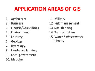
APPLICATION AREAS OF GIS
Agriculture
Business
Electric/Gas utilities
Environment
Forestry
Geology
Hydrology
Land-use planning
Local government
Mapping
11. Military
12. Risk management
13. Site planning
14. Transportation
15. Water / Waste water industry
COMPONENTS OF GIS
DATA INPUT
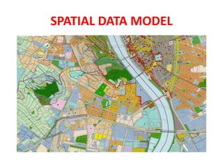
SPATIAL DATA MODEL
Data Model:
It describes in an abstract way how the data is represented in an information system or in DBMS
Spatial Data Model :
The models or abstractions of reality that are intended to have some similarity with selected aspects of the real world
Creation of analogue and digital spatial data sets involves seven levels of model development and abstraction
SPATIAL DATA MODEL
Conceptual model : A view of reality
Analog model : Human conceptualization leads to analogue abstraction
Spatial data models : Formalization of analogue abstractions without any conventions
Database model : How the data are recorded in the computer
Physical computational model : Particular representation of the data structures in computer memory
Data manipulation model : Accepted axioms and rules for handling the data
SPATIAL DATA MODEL
SPATIAL DATA MODEL
Objects on the earth surface are shown as continuous and discrete objects in spatial data models
Types of data models
Raster data model
vector data models
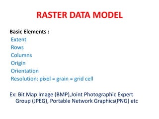
RASTER DATA MODEL
Basic Elements :
Extent
Rows
Columns
Origin
Orientation
Resolution: pixel = grain = grid cell
Ex: Bit Map Image (BMP),Joint Photographic Expert Group (JPEG), Portable Network Graphics(PNG) etc
RASTER DATA MODEL
VECTOR DATA MODEL
Basic Elements:
Location (x,y) or (x,y,z)
Explicit, i.e. pegged to a coordinate system
Different coordinate system (and precision) require different values
o e.g. UTM as integer (but large)
o Lat, long as two floating point numbers +/-
Points are used to build more complex features
Ex: Auto CAD Drawing File(DWG), Data Interchange(exchange) File(DXF), Vector Product Format (VPF) etc
VECTOR DATA MODEL
RASTER vs VECTOR Raster is faster but Vector is corrector
TESSELLATIONS OF CONTINUOUS FIELDS
Triangular Irregular Network: (TIN)
TIN is a vector data structure for representing geographical information that is continuous
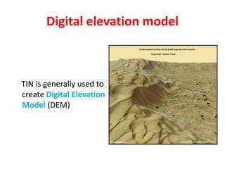
Digital elevation model
TIN is generally used to create Digital Elevation Model (DEM)
DIGITAL ELEVATION MODEL
DATA STRUCTURES
Data structure tells about how the data is stored
Data organization in raster data structures
Each cell is referenced directly
Each overlay Is referenced directly
Each mapping unit is referenced directly
Each overlay is separate file with general header
3. DEFINITION :
GIS is a powerful set of tools for collecting,
storing , retrieving at will, transforming and
displaying spatial data from the real world for
a particular set of purposes
4. APPLICATION AREAS OF GIS
1. Agriculture
2. Business
3. Electric/Gas utilities
4. Environment
5. Forestry
6. Geology
7. Hydrology
8. Land-use planning
9. Local government
10. Mapping
11. Military
12. Risk management
13. Site planning
14. Transportation
15. Water / Waste water
industry
8. SPATIAL DATA MODEL
Data Model:
It describes in an abstract way how the data is represented
in an information system or in DBMS
Spatial Data Model :
The models or abstractions of reality that are intended to
have some similarity with selected aspects of the real world
Creation of analogue and digital spatial data sets involves
seven levels of model development and abstraction
9. SPATIAL DATA MODEL
1. Conceptual model : A view of reality
2. Analog model : Human conceptualization leads to analogue abstraction
3. Spatial data models : Formalization of analogue abstractions without
any conventions
4. Database model : How the data are recorded in the computer
5. Physical computational model : Particular representation of the data
structures in computer memory
6. Data manipulation model : Accepted axioms and rules for handling the
data
11. Objects on the earth surface are shown as
continuous and discrete objects in spatial
data models
Types of data models
Raster data model
vector data models
SPATIAL DATA MODEL
12. RASTER DATA MODEL
Basic Elements :
Extent
Rows
Columns
Origin
Orientation
Resolution: pixel = grain = grid cell
Ex: Bit Map Image (BMP),Joint Photographic Expert
Group (JPEG), Portable Network Graphics(PNG) etc
14. VECTOR DATA MODEL
Basic Elements:
Location (x,y) or (x,y,z)
Explicit, i.e. pegged to a coordinate system
Different coordinate system (and precision) require different
values
– o e.g. UTM as integer (but large)
– o Lat, long as two floating point numbers +/-
Points are used to build more complex features
Ex: Auto CAD Drawing File(DWG), Data Interchange(exchange)
File(DXF), Vector Product Format (VPF) etc
22. DATA STRUCTURES
Data structure tells about how the data is stored
Data organization in raster data structures
1. Each cell is referenced directly
2. Each overlay Is referenced directly
3. Each mapping unit is referenced directly
4. Each overlay is separate file with general header
23. DATA ANLYSIS
• Attribute operations
• Distance or location operations
• Operations using in-built spatial topology
Mathematical operations
a) Logical operations (union,intersection,nagation etc)
b) Arithmetical operations(subtraction, addition etc)
c) Trigonometric operations (sine, cosine ,tan etc)
d) Data type operations( Boolean, ordinal, directional etc)
e) Statistical operations ( mean, mode, median etc)
f) Multivariate operations (factor analysis , probability, fuzzy
logic etc)
25. BUFFERING TECHNIQUES
• Buffering is a creation of
polygons that surround
other points
• Is a zone of polygon created
as a zone of influence
around an entity
• Buffer around a second
buffer is called doughnut
buffer
ADVANTAGES:
• Analyzing the landscapes ,
environmental problems
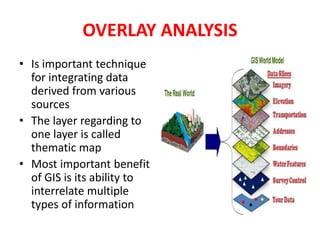
26. OVERLAY ANALYSIS
• Is important technique
for integrating data
derived from various
sources
• The layer regarding to
one layer is called
thematic map
• Most important benefit
of GIS is its ability to
interrelate multiple
types of information
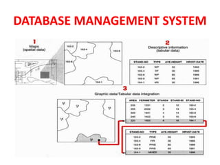
27. DATABASE MANAGEMENT SYSTEM
DATABASE:
Where all the spatial and non-spatial information
is stored in a logical order
DATABASE MANAGEMENT SYSTEM (DBMS) :
The programs which are used to access the data
stored in database
DATABASE SYSTEM: DATABASE+DBMS
30. FUNCTIONS OF DBMS
SECURITY: Not all users should have all modes
of access to a database
INTEGRITY: Backup and recovery
SYNCHRONISATION : Inconsistencies that can
result from multiple simultaneous users
PHYSICAL DATA INDEPENDENCE : Data and
application programs that operate on them
are independent on hardware and technology