


Kevin lynch
- 1. PIONEERS OF TOWN PLANNING KEVIN LYNCH Ar.AyazAhmad Khan Assistant Professor InvertisUniversity
- 2. ABSTRACT “There seems to be a public image of any given city which is the overlap of many individual images. Or perhaps there is a series of public images, each held by some significant number of citizens. Such group images are necessary if an individual is to operate successfully within his environment and to cooperate with his fellows. Each individual picture is unique. with some content that is rarely or never communicated, yet it approximates the public image, which, in different environments, is more or less compelling, more or less embracing.” Kevin A. Lynch
- 3. INTRODUCTION •Kevin Andrew Lynch was born on 7th Jan 1918 & died on 25th April 1984. •He was an American urban planner & author. •He is best known for his work on mental mapping & on perceptual form of urban environments. •His famous book The Image of the City which he published in 1960 is very famous among his works. •He was a disciple of FLW before he studied city planning, & spend his academic career at the Massachusetts Institute ofTechnology, teaching there. •He practice site planning and urban design
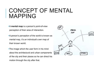
- 4. CONCEPT OF MENTAL MAPPING A mental map is a person's point-of-view perception of their area of interaction. A person’s perception of the world is known as mental map, it’s an individual’s own map of their known world. The image which the user form in his mind about the architectural and urban components of the city and their places so he can direct his motion through the city after that.
- 5. CONCEPT OF MENTAL MAPPING Mental maps of an individual can be investigated by: Asking for directions to a landmark or other location. Asking someone to draw a sketch map of an area or describe that area. Asking a person to name as many places as possible in short period of time.
- 6. CONCEPT OF MENTAL MAPPING Mental image properties : The overall mental image of an urban environment will be: 1. Partial : not covering the whole city 2. Simplified : omitting a great deal of information 3. Unique : each individual has his/her own 4. Distorted : not necessary has real distance or direction.
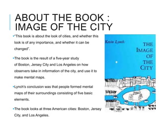
- 7. ABOUT THE BOOK : IMAGE OF THE CITY “This book is about the look of cities, and whether this look is of any importance, and whether it can be changed”. The book is the result of a five-year study of Boston, Jersey City and Los Angeles on how observers take in information of the city, and use it to make mental maps. Lynch's conclusion was that people formed mental maps of their surroundings consisting of five basic elements. The book looks at three American cities: Boston, Jersey City, and Los Angeles.
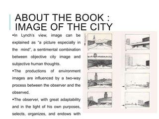
- 8. ABOUT THE BOOK : IMAGE OF THE CITY In the first section, new concepts of legibility and Imageability are presented to lay the theoretical foundation of the entire book. Followed by that, Lynch introduced three American cities as examples to reveal his outcomes of field reconnaissance, and then made comparisons between each other. In the third section, five elements and their interrelationships are summarized from previous researches which act as the core content of the book.
- 9. ABOUT THE BOOK : IMAGE OF THE CITY In Lynch’s view, image can be explained as “a picture especially in the mind”, a sentimental combination between objective city image and subjective human thoughts. The productions of environment images are influenced by a two-way process between the observer and the observed. The observer, with great adaptability and in the light of his own purposes, selects, organizes, and endows with
- 10. THEORY - FIVE POINTS Kevin Lynch found that there are five basic elements which people use to construct their mental image of a city: Pathways Districts Edges Landmarks Nodes
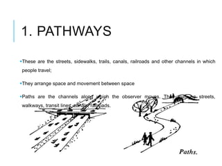
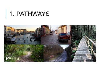
- 11. 1. PATHWAYS These are the streets, sidewalks, trails, canals, railroads and other channels in which people travel; They arrange space and movement between space Paths are the channels along which the observer moves. They may be streets, walkways, transit lines, canals, railroads.
- 12. 1. PATHWAYS
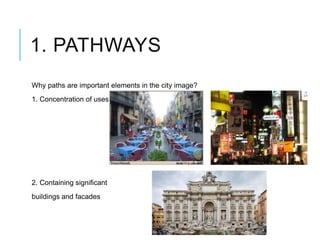
- 13. 1. PATHWAYS Why paths are important elements in the city image? 1. Concentration of uses 2. Containing significant buildings and facades
- 14. 1. PATHWAYS Why paths are important elements in the city image? 3. paths are the most important elements in people’s images : • other elements are arranged and along them. • Unclear paths = unclear city
- 15. 2. EDGES Boundaries; They can be either Real or Perceived; These are walls, buildings, and shorelines, curbstone, streets, overpasses, etc. Edges are linear elements that form boundaries between areas or linear breaks in continuity (e.g. shores, railway cuts, walls).
- 16. 2. EDGES
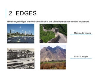
- 17. 2. EDGES The strongest edges are continuous in form, and often impenetrable to cross movement.
- 18. 2. EDGES The strongest edges are continuous in form, and often impenetrable to cross movement. Manmade edges Natural edges
- 19. DIFFERENCE BETWEEN PATH & EDGE Edges : Prevent motion in specific direction Paths : Direct the motion to specific direction
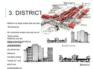
- 20. 3. DISTRICTS Medium to large areas that are two- dimensional; An individual enters into and out of these areas; Have common identifying characteristics. Districts are the medium-to-large sections of the city which the observer mentally enters "inside of," and which are recognizable as
- 21. 3. DISTRICTS
- 22. 3. DISTRICTS Are the medium to large parts of the city which share the same characteristics Style - spatial form, topography- colors, texture, urban fabric
- 23. 3. DISTRICTS Districts may have Clear edges, or soft uncertain ones gradually fading away into surrounding areas.
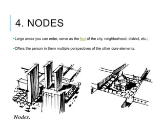
- 24. 4. NODES Large areas you can enter, serve as the foci of the city, neighborhood, district, etc.; Offers the person in them multiple perspectives of the other core elements.
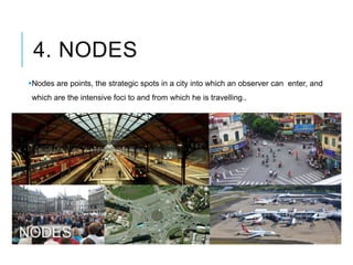
- 25. 4. NODES Nodes are points, the strategic spots in a city into which an observer can enter, and which are the intensive foci to and from which he is travelling.. They may be primarily junctions or concentrations.
- 26. 4. NODES Strategic points in the city that: • the user can enter it • be directed to many destinations • it can be gathering places or intersection of paths, or places for activities
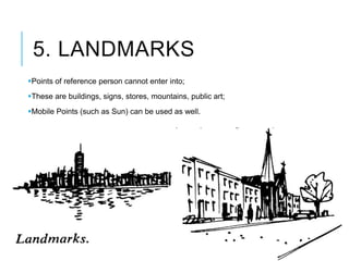
- 27. 5. LANDMARKS Points of reference person cannot enter into; These are buildings, signs, stores, mountains, public art; Mobile Points (such as Sun) can be used as well.
- 28. 5. LANDMARKS Landmarks are another type of point-reference, but in this case the observer does not enter within them, they are external. They are usually a rather simply defined physical object: building, sign, store, or mountain.
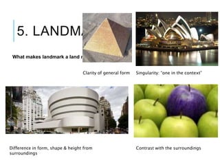
- 29. 5. LANDMARKS A physical element with unique and special visual features that has a "point-specific” location, and can be identified from the distance.
- 30. 5. LANDMARKS What makes landmark a land mark? Singularity: “one in the context” Contrast with the surroundings Clarity of general form Difference in form, shape & height from surroundings
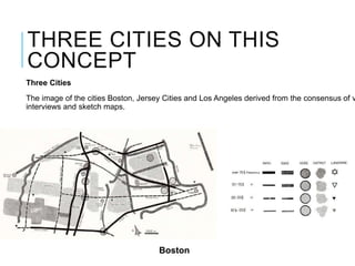
- 32. THREE CITIES ON THIS CONCEPT Three Cities The image of the cities Boston, Jersey Cities and Los Angeles derived from the consensus of v interviews and sketch maps. Boston
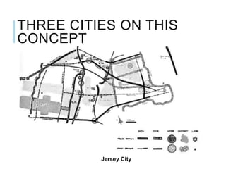
- 33. THREE CITIES ON THIS CONCEPT Jersey City
- 34. THREE CITIES ON THIS CONCEPT Los Angeles
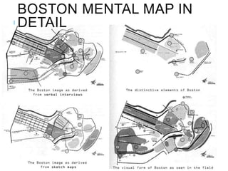
- 35. BOSTON MENTAL MAP IN DETAIL
- 36. THUS IMAGE OF THE CITY None of lynch’s elements exits in isolation : all combine to provide the overall image: • Districts are structures with nodes • Edges define Districts • Paths introduction to Districts • Nodes sprinkled by landmarks …. • Nodes emphasizes the connection between paths All combine to provide the overall image of the city
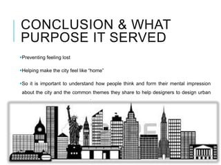
- 37. CONCLUSION & WHAT PURPOSE IT SERVED Preventing feeling lost Helping make the city feel like “home” So it is important to understand how people think and form their mental impression about the city and the common themes they share to help designers to design urban environment in a clear manner for users
- 38. THANKYOU…