Location via proxy:   [ UP ]  
[Report a bug]   [Manage cookies]                
SlideShare a Scribd company logo

1

Plate Tectonics

2

The fit of the continents at a
water depth of 137 meters.

3

Key Ideas Plate
Tectonics
Earth is composed of
layers. These layers have
different chemical and
physical properties.

4

Key Ideas Plate
Tectonics
Large regions of Earth’s
continents are held above sea
level by isostatic equilibrium.

5

Key Ideas Plate
Tectonics
Researchers have learned
about Earth’s layers by
studying waves generated by
earthquakes.

6

Key Ideas Plate
Tectonics
Plate tectonic theory
suggests that Earth’s surface
is divided into segments
called lithospheric plates,
which move, collide, and
slide past one another.

7

Key Ideas Plate
Tectonics
One force that drives plate
motion is heat-driven
convection currents in the
mantle. The heat is generated
by the decay of radioactive
elements within Earth.

8

Key Ideas Plate
Tectonics
Plate tectonics explains the
large-scale features of Earth’s
surface, and the young age of
the seafloors.

9

Key Ideas Plate
Tectonics
Many scientific disciplines
have contributed to the
confirmation of the theory of
plate tectonics.

10

A Layered Earth - Density
Density is a key concept for understanding
the structure of Earth.
Density measures the mass per unit volume
of a substance.
Density = Mass
Volume
Density is expressed as grams per cubic
centimeter.
Water has a density of 1 g/cm3

11

A cross section
of Earth showing
the internal
layers. These
layers can be
described by
their chemical
and physical
characteristics.
Layered Earth

12

What evidence supports the idea that Earth has layers?
The behavior of seismic waves generated by earthquakes
give scientists some of the best evidence about the structure
of Earth.
(above-left) S waves cannot penetrate Earth’s liquid core.
(above-right) P waves are bent as they pass through the liquid
outer core.
Evidence Of Earth’s
Layers

13

Chemical Properties of Earth’s Layers
Layer Chemical Properties
Continental
Crust
Composed primarily of granite
density = 2.7 g/cm3
Oceanic
Crust
Composed primarily of basalt
density = 2.9 - 3.3 g/cm3
Mantle Composed of silicon, oxygen,
iron and magnesium
density = 4.5 g/cm3
Core Composed mainly of iron
Density = 13 g/cm3
Note that Earth is density stratified, that is, each
deeper layer is denser than the layer above.

14

Relative Abundance of Elements

15

Physical Properties of Earth’s Layers
Layer Physical Properties
Lithosphere The cool, rigid outer layer
Asthenosphere Hot, partially melted layer which
flows slowly
Mantle Denser and more slowly flowing
than the asthenosphere
Outer Core Dense, viscous liquid layer,
extremely hot
Inner Core Solid, very dense & extremely hot
A cool, rigid, less dense layer (the lithosphere) floats
on a hot, slowly-flowing, more dense layer (the
asthenosphere).

16

Why don’t tall mountains sink into the
asthenosphere? How are features such as
mountains supported?
The concept of buoyancy is illustrated by a ship on the ocean. The ship sinks until
it displaces a volume of water equal to the weight of the ship and its contents.
Isostatic Equilibrium
(right) Earth’s
lithosphere is supported
on the asthenosphere in
a similar manner, with a
few important
differences. Instead of
buoyancy, the term
isostatic equilibrium
describes the way the
lithosphere is supported
on the asthenosphere.

17

Isostatic
Equilibriu
m

18

Nature of Crustal Material
• Ocean floor
– develops in 200 million year cycle
– no floor older than 200 million years
• oldest known is 175 million years

19

Nature of Crustal
Material
• Ocean floor
– develops in 200 million year cycle
– no floor older than 200 million years
• oldest known is 175 million years
• Continental Material
– less dense than ocean floor and therefore floats
atop it
– very old cores
• core of North America ~2 billion years old
– fragmented by plate tectonics
– grown by aggregation due to plate tectonics

20

•Group of rocks all moving in
the same direction
•Can have both oceanic and
continental crust or just one
kind.
Plates

21

Earth’s Crustal Plates
• About 12 major rigid plates and
many microplates
• plates slide over partially molten,
weak aesthenosphere
• continents are embedded in plates
and are carried along passively

22

The major lithospheric plates and their direction
of relative movement are shown here.
The Major Lithospheric
Plates

23

Types of plate
boundaries
• divergent: mid-ocean ridges
• convergent: collision zones
volcanic arcs
• transform: San Andreas fault,
North Anatolian Fault, Turkey.

24

Divergent Plate Boundary

25

Sea-floor spreading leads to
CONTINENTAL DRIFT

26

Rifting and
Seafloor
Spreading
Along the
Mid-Atlantic
Ridge
Peter W. Sloss, NOAA-NESDIS-NGDC

27

Rifting and Seafloor Spreading

28

Inception of Rifting Within a
Continent

29

Nile Delta
Gulf of
Suez
Gulf of
‘Aqaba
Red Sea
Earth Satellite Corp.

30

The Gulf of
California
Formed by
Rifting of
Baja
California
from
Mainland
Mexico
Worldsat International/Photo Researchers

31

Convergent boundaries
• New crust created at MOR—old crust
destroyed (recycled) at subduction
zones (i.e., the Earth is not
expanding)
• Relative important densities:
continental crust ≈ 2.7 g/cm3
oceanic crust ≈ 2.9 - 3.2 g/cm3
asthenosphere ≈ 4.5 g/cm3

32

Oceanic Convergent Boundary
Sea Floor Trench

33

Convergent boundaries
3 types:
ocean–ocean Philippines
ocean–continent Andes
continent–continent Himalayas

34

Ocean–Ocean
Island arcs:
• Tectonic belts of high seismic
energy
• High heat flow arc of active
volcanoes
• Bordered by a submarine
trench

35

Fig. 20.6b
Ocean–Ocean
Subduction Zone

36

Volcanic Island Arc

37

Ocean–Continent
Continental arcs:
• Active volcanoes
• Often accompanied by
compression of upper crust

38

Fig. 20.6a
Ocean-Continent
Subduction Zone

39

Continent–Continent
• Folding (shortening and
thickening)
• Reverse faulting
• Underthrusting
(intracontinental subduction)

40

Fig. 20.6c
Continent-Continent
Collision

41

Himalayas and Tibetan Plateau
• Product of the collision
between India and Asia.
• Collision began about 45 M
yr. ago, continues today.
• Before collision, southern Asia
looked something like the
Andes do today.

42

Formation of the Himalayas

43

Elizabeth J. Catlos

44

Locations where crustal plates move past one
another, for example, the San Andreas fault.
Transform Boundary
(above) Translation at transform boundaries causes shear.

45

How old is Earth?
The age of Earth has been subject to debate.
Scientists now use an age of 4.6 billion years.
The principle of uniformitarianism was
introduced in 1788. This principle sates that the
forces which shaped Earth are identical to forces
working today.
Catastrophism is the thought that Earth is very
young, and events described in the Bible are
responsible for the appearance of Earth’s features.
-- Usher 9:00am Oct. 23, 4004 BC

46

T. C. Chamberlin and R. D. Salisbury,
1904
Computed the amount of shrinkage (of Earth) for a
given amount of cooling and concluded that “It is
obvious that if the Earth shrinks, its crust must
become too large for the reduced spheroid, and
must be compressed or distorted to fit the new form.

47

What drives plate
tectonics?

48

Where does the heat within Earth’s
layers come from?
Radioactive decay
This heat travels in convection currents in the
mantle.
Internal Heat

49

New Evidence Supports Wegener’s Theory
of Continental Drift
Wegener’s theory of continental drift was out
of favor with the scientific community until new
technology provided evidence to support his
ideas.
• Seismographs revealed a pattern of
volcanoes and earthquakes
•Radiometric dating of rocks revealed a
surprisingly young oceanic crust.
• Echo sounders revealed the shape of the
Mid-Atlantic Ridge

50

Seafloor spreading was an
idea proposed in 1960 to
explain the features of the
ocean floor. It explained the
development of the seafloor
at the Mid-Atlantic Ridge.
Convection currents in the
mantle were proposed as
the force that caused the
ocean to grow and the
continents to move.
(right) The Mid-Atlantic
Ridge conforms to the
shape of the adjacent
continents. The inset shows
the central rift.
Seafloor Spreading - A Key Idea

51

(above-left and above-right) The patterns of paleomagnetism support plate
tectonic theory. The molten rocks at the spreading center take on the polarity
of the planet while they are cooling. When Earth’s polarity reverses, the
polarity of newly formed rock changes.
Paleomagnetism: strips of alternating magnetic polarity at spreading regions.
Confirmation of the Theory of
Plate Tectonics

52

Apparent Polar wandering:
plate movement causes the
apparent position of the
magnetic poles to have
shifted.
Confirmation of the Theory of
Plate Tectonics

53

Kuliah GL-3  (Plate Tec).ppt

54

Hot Spots: Surface expression of plumes of magma.
Confirmation of the
Theory of Plate Tectonics
A volcanic island chain can form when a plate passes
over a hot spot and a stationary mantle plume.

55

Atolls and Guyots: Coral formations and submerged volcanic mountains.
(above) Guyots were once volcanic peaks above sea level. They were
eroded by wave action as they sank beneath the surface of the water.
Confirmation of the
Theory of Plate Tectonics

56

Kuliah GL-3  (Plate Tec).ppt

57

Kuliah GL-3  (Plate Tec).ppt

58

Kuliah GL-3  (Plate Tec).ppt

59

Age and distribution of ocean sediments:
The sediment in the ocean is thinner and
younger than the age of the ocean indicates
it should be.
The Oceanic ridges: Oceanic ridges are
clear indicators of past events.
Terranes: Oceanic plateaus that form by
uplifting and mountain building as they strike
a continent.
Confirmation of the
Theory of Plate
Tectonics

60

Through the great expanse of geologic time, this slow
movement remakes the surface of Earth, expands and splits
continents, and forms and destroys ocean basins.
Summary

More Related Content

Kuliah GL-3 (Plate Tec).ppt

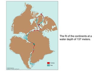
  • 2. The fit of the continents at a water depth of 137 meters.
  • 3. Key Ideas Plate Tectonics Earth is composed of layers. These layers have different chemical and physical properties.
  • 4. Key Ideas Plate Tectonics Large regions of Earth’s continents are held above sea level by isostatic equilibrium.
  • 5. Key Ideas Plate Tectonics Researchers have learned about Earth’s layers by studying waves generated by earthquakes.
  • 6. Key Ideas Plate Tectonics Plate tectonic theory suggests that Earth’s surface is divided into segments called lithospheric plates, which move, collide, and slide past one another.
  • 7. Key Ideas Plate Tectonics One force that drives plate motion is heat-driven convection currents in the mantle. The heat is generated by the decay of radioactive elements within Earth.
  • 8. Key Ideas Plate Tectonics Plate tectonics explains the large-scale features of Earth’s surface, and the young age of the seafloors.
  • 9. Key Ideas Plate Tectonics Many scientific disciplines have contributed to the confirmation of the theory of plate tectonics.
  • 10. A Layered Earth - Density Density is a key concept for understanding the structure of Earth. Density measures the mass per unit volume of a substance. Density = Mass Volume Density is expressed as grams per cubic centimeter. Water has a density of 1 g/cm3
  • 11. A cross section of Earth showing the internal layers. These layers can be described by their chemical and physical characteristics. Layered Earth
  • 12. What evidence supports the idea that Earth has layers? The behavior of seismic waves generated by earthquakes give scientists some of the best evidence about the structure of Earth. (above-left) S waves cannot penetrate Earth’s liquid core. (above-right) P waves are bent as they pass through the liquid outer core. Evidence Of Earth’s Layers
  • 13. Chemical Properties of Earth’s Layers Layer Chemical Properties Continental Crust Composed primarily of granite density = 2.7 g/cm3 Oceanic Crust Composed primarily of basalt density = 2.9 - 3.3 g/cm3 Mantle Composed of silicon, oxygen, iron and magnesium density = 4.5 g/cm3 Core Composed mainly of iron Density = 13 g/cm3 Note that Earth is density stratified, that is, each deeper layer is denser than the layer above.
  • 14. Relative Abundance of Elements Relative Abundance of Elements
  • 15. Physical Properties of Earth’s Layers Layer Physical Properties Lithosphere The cool, rigid outer layer Asthenosphere Hot, partially melted layer which flows slowly Mantle Denser and more slowly flowing than the asthenosphere Outer Core Dense, viscous liquid layer, extremely hot Inner Core Solid, very dense & extremely hot A cool, rigid, less dense layer (the lithosphere) floats on a hot, slowly-flowing, more dense layer (the asthenosphere).
  • 16. Why don’t tall mountains sink into the asthenosphere? How are features such as mountains supported? The concept of buoyancy is illustrated by a ship on the ocean. The ship sinks until it displaces a volume of water equal to the weight of the ship and its contents. Isostatic Equilibrium (right) Earth’s lithosphere is supported on the asthenosphere in a similar manner, with a few important differences. Instead of buoyancy, the term isostatic equilibrium describes the way the lithosphere is supported on the asthenosphere.
  • 18. Nature of Crustal Material • Ocean floor – develops in 200 million year cycle – no floor older than 200 million years • oldest known is 175 million years
  • 19. Nature of Crustal Material • Ocean floor – develops in 200 million year cycle – no floor older than 200 million years • oldest known is 175 million years • Continental Material – less dense than ocean floor and therefore floats atop it – very old cores • core of North America ~2 billion years old – fragmented by plate tectonics – grown by aggregation due to plate tectonics
  • 20. •Group of rocks all moving in the same direction •Can have both oceanic and continental crust or just one kind. Plates
  • 21. Earth’s Crustal Plates • About 12 major rigid plates and many microplates • plates slide over partially molten, weak aesthenosphere • continents are embedded in plates and are carried along passively
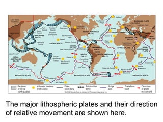
  • 22. The major lithospheric plates and their direction of relative movement are shown here. The Major Lithospheric Plates
  • 23. Types of plate boundaries • divergent: mid-ocean ridges • convergent: collision zones volcanic arcs • transform: San Andreas fault, North Anatolian Fault, Turkey.
  • 25. Sea-floor spreading leads to CONTINENTAL DRIFT
  • 27. Rifting and Seafloor Spreading
  • 28. Inception of Rifting Within a Continent
  • 29. Nile Delta Gulf of Suez Gulf of ‘Aqaba Red Sea Earth Satellite Corp.
  • 30. The Gulf of California Formed by Rifting of Baja California from Mainland Mexico Worldsat International/Photo Researchers
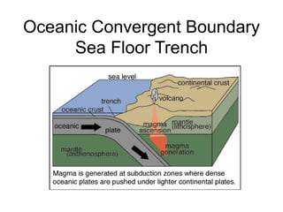
  • 31. Convergent boundaries • New crust created at MOR—old crust destroyed (recycled) at subduction zones (i.e., the Earth is not expanding) • Relative important densities: continental crust ≈ 2.7 g/cm3 oceanic crust ≈ 2.9 - 3.2 g/cm3 asthenosphere ≈ 4.5 g/cm3
  • 33. Convergent boundaries 3 types: ocean–ocean Philippines ocean–continent Andes continent–continent Himalayas
  • 34. Ocean–Ocean Island arcs: • Tectonic belts of high seismic energy • High heat flow arc of active volcanoes • Bordered by a submarine trench
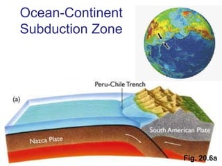
  • 37. Ocean–Continent Continental arcs: • Active volcanoes • Often accompanied by compression of upper crust
  • 39. Continent–Continent • Folding (shortening and thickening) • Reverse faulting • Underthrusting (intracontinental subduction)
  • 41. Himalayas and Tibetan Plateau • Product of the collision between India and Asia. • Collision began about 45 M yr. ago, continues today. • Before collision, southern Asia looked something like the Andes do today.
  • 42. Formation of the Himalayas
  • 44. Locations where crustal plates move past one another, for example, the San Andreas fault. Transform Boundary (above) Translation at transform boundaries causes shear.
  • 45. How old is Earth? The age of Earth has been subject to debate. Scientists now use an age of 4.6 billion years. The principle of uniformitarianism was introduced in 1788. This principle sates that the forces which shaped Earth are identical to forces working today. Catastrophism is the thought that Earth is very young, and events described in the Bible are responsible for the appearance of Earth’s features. -- Usher 9:00am Oct. 23, 4004 BC
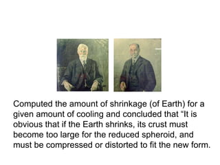
  • 46. T. C. Chamberlin and R. D. Salisbury, 1904 Computed the amount of shrinkage (of Earth) for a given amount of cooling and concluded that “It is obvious that if the Earth shrinks, its crust must become too large for the reduced spheroid, and must be compressed or distorted to fit the new form.
  • 48. Where does the heat within Earth’s layers come from? Radioactive decay This heat travels in convection currents in the mantle. Internal Heat
  • 49. New Evidence Supports Wegener’s Theory of Continental Drift Wegener’s theory of continental drift was out of favor with the scientific community until new technology provided evidence to support his ideas. • Seismographs revealed a pattern of volcanoes and earthquakes •Radiometric dating of rocks revealed a surprisingly young oceanic crust. • Echo sounders revealed the shape of the Mid-Atlantic Ridge
  • 50. Seafloor spreading was an idea proposed in 1960 to explain the features of the ocean floor. It explained the development of the seafloor at the Mid-Atlantic Ridge. Convection currents in the mantle were proposed as the force that caused the ocean to grow and the continents to move. (right) The Mid-Atlantic Ridge conforms to the shape of the adjacent continents. The inset shows the central rift. Seafloor Spreading - A Key Idea
  • 51. (above-left and above-right) The patterns of paleomagnetism support plate tectonic theory. The molten rocks at the spreading center take on the polarity of the planet while they are cooling. When Earth’s polarity reverses, the polarity of newly formed rock changes. Paleomagnetism: strips of alternating magnetic polarity at spreading regions. Confirmation of the Theory of Plate Tectonics
  • 52. Apparent Polar wandering: plate movement causes the apparent position of the magnetic poles to have shifted. Confirmation of the Theory of Plate Tectonics
  • 54. Hot Spots: Surface expression of plumes of magma. Confirmation of the Theory of Plate Tectonics A volcanic island chain can form when a plate passes over a hot spot and a stationary mantle plume.
  • 55. Atolls and Guyots: Coral formations and submerged volcanic mountains. (above) Guyots were once volcanic peaks above sea level. They were eroded by wave action as they sank beneath the surface of the water. Confirmation of the Theory of Plate Tectonics
  • 59. Age and distribution of ocean sediments: The sediment in the ocean is thinner and younger than the age of the ocean indicates it should be. The Oceanic ridges: Oceanic ridges are clear indicators of past events. Terranes: Oceanic plateaus that form by uplifting and mountain building as they strike a continent. Confirmation of the Theory of Plate Tectonics
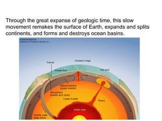
  • 60. Through the great expanse of geologic time, this slow movement remakes the surface of Earth, expands and splits continents, and forms and destroys ocean basins. Summary