Location via proxy:   [ UP ]  
[Report a bug]   [Manage cookies]                
SlideShare a Scribd company logo

1

Where is Earth in the
Universe??
What is the earth
made out off???

2

2. The Dynamics of Earth
Sub-Unit
2. The Dynamics of Earth:
 Continental drift
 Earth’s structure
 Types of Plate Margins
 Seafloor spreading
 Plate motion on the surface of the sphere
 Forces driving plate tectonic motions

3

2. The Dynamics of Earth
Objectives
 Know what is a continental drift
and the factors causing it
 Identify different layers that
made up the spherical earth
 Identify different types of Plate
Margins
 Understand Seafloor spreading
 Know how plates are moving on
the surface of the sphere
 Categories forces driving plate
tectonic motions

4

• Is a dynamic planet, endlessly changing both internally
And externally
Processes of transforming the
surface of earth
1. endogenic processes (i.e., of
internal origin)- by volcanism
and tectonism, metamorphism ,
earthquakes , crustal warping ,
folding and faulting .
The Earth

5

2. Exogenic processes (i.e., of external origin) -
such as weathering, erosion, transportation,
deposition, denudation.
• Also, Earth surface is deformed by geological
processes at rates that are extremely slow in
human terms, cm per year
weathering, erosion, transportation
deposition
Pacific Plate - North American Plate –
5cm/year
Mt William
Wara Simbu
Purari

6

Hypotheses to explain the underlying mechanisms causing
dynamics of earth
Hypothesis of a Contracting Earth (late nineteenth)
- shrinking cause mountains like wrinkles
• Propose Southern landmass combine
into one great continent in Palaeozoic
times called Gondwanaland.
(Africa, Antarctica, Arabia, Australia,
India and South America).
In the late nineteenth century - Austrian
geologist Eduard Suess
• In 1912 - German meteorologist Alfred
Wegener proposed the idea of Super
Continent called Pangea (Greek: All
the Earth)
Formation of Nappe structures in the Alps

7

• Alexander Du Toit, a South African
geologist, (1937) proposed that “northern
continents” are all combine as Laurasia.
(North America (including Greenland),
Europe and most of Asia)
Laurasia and Gondwanaland split apart
in the Early Mesozoic
Super Continent of Pangae Land is
supported by the proposed Laurasia
and Gondwanaland
The hypothesis of Displacement was
Born!

8

1.2.2 Continental drift
Continental Drift was proposed by “Displacement hypothesis”
• crustal blocks having
continental dimensions
are making large-scale
horizontal displacement
continental drift,
• The displacements take
place slowly over long time
intervals.
Wegener’s reconstruction of Pangaea

9

Computer-assisted reconstructions
Pangaea Reconstruction
The traces of opposite continental
margins were matched by an iterative
procedure
They digitized the continental
outlines
• approximately 50 km
intervals for different depth
• (900 m) depth was used for
matching

10

Geographical and Magnetic Poles
Earth magnetic field
(Geomagnetic Field)
• points vertically
downward in the North
Pole
• Points vertically upward
in the South Pole
• Forms earths
magnetosphere
• Can change polarity over
time
• caused by electric
currents in the liquid
outer core
Palaeomagnetism and continental drift

11

Palaeomagnetism and continental drift
Palaeomagnetism - study of the past record of the direction and
intensity of Earth's magnetic (geomagnetic field) field in rocks by
oxides of iron (magnetite, hematite, maghemite) when they form.
• Magnetic Pole Changes with
respect to time

12

(a) In hot lava flows, thermal
energy exceeds atomic magnetic
exchange energy and the magnetic
moments (movements) are
randomized.
(b) When the lava cools,
magnetic moment aligns parallel
to the ambient geomagnetic field.
(c) When magnetic particles are
eroded from a source rock and are
deposited as a sediment, the
particles may align with the
geomagnetic field to give rise to a
depositional remanent
magnetization (DRM).
How rocks acquire a remanent magnetization?

13

Virtual geomagnetic pole (VGP)
position –calculation of the
position of the magnetic pole at the
time in which rocks get magnetised
• By connecting mean VGP
positions of different ages
for sites on the same
continent apparent polar
wander path is obtain
Conclude that poles are not
moving but continents are!!
Apparent polar wander (APW) -The
appearance that the pole has shifted
with time
• retrace the relative motion of
continents,
• formation and break-up of
supercontinents

14

Earth structure
Early in the twentieth
century it became evident
from the study of seismic
waves
• interior of the Earth has a
radially layered structure
• boundaries are marked by
abrupt changes in
seismic velocity or
velocity gradient
• Each layer is
characterized by
composition, pressure
and temperature in the
layer
• Four main layers are the
crust, mantle and the
outer and inner cores

15

• S waves cannot pass through
fluid while P waves can
• shadow zone -angular
distances of 104 to 140 degrees
from a given earthquake that
does not receive any direct P
waves
• Only refracted P waves arrive
at position opposite the
epicentre
How seismic is used to determination of the properties of
the Four Layer
P and S Waves

16

Depths of the most
important seismic
discontinuities
giving boundaries
of layer
Inner Core
Solid;
Radius of Earth
1. Crust
2. Upper Mantle
• Lithosphere
• Asthenosphere
3. Lower Mental
• Mesosphere
4. Outer Core
5. Inner Core

17

Lithospheric plates
• Lithosphere- crust and uppermost
mantle are rigid, forming a hard
outer shell
• Asthenosphere- weaker layer may
be able to flow over long periods of
time like a viscous liquid or plastic
solid,
• The convection current in the
mental causes relative motions of
the overlying lithospheric plates
• when strongly stressed, fracture
happens causing earthquake.
Ridge
Lithosphere
Asthenosphere
Trench
Trench Ridge
This action
• resulted in the plate movements
• Seismic zones of the earth
Earthquakes – is a violent release of elastic
energy due to sudden displacement on a
fault plane

18

Seismic Belts:
(a) the circum-Pacific “ring of fire”;
(b) a sinuous belt running from the Azores through North Africa and the
Alpine–Dinaride–Himalayan mountain chain as far as S.E. Asia; and
(c) the world-circling system of oceanic ridges and rises.
Seismic Zones of the Earth

19

Tectonic plates
Tectonic plates - fragmented slabs of
lithosphere that visible trough
boundaries called tectonic plate
boundaries.
• Sizes range: 1000 - 10,000 sq. km
(e.g., the Pacific plate and Philippines
plate)
• Movement – mm-cm/year
• Twelve major plates - (Antarctica,
Africa, Eurasia, India, Australia,
Arabia, Philippines, North America,
South America, Pacific, Nazca, and
Cocos) and several minor plates (e.g.,
Scotia, Caribbean, Juan de Fuca).
The seismic zones subdivide the lithosphere laterally into tectonic plates

20

Lecture 2-The Dynamic Earth.pdf

21

2. Divergent - two tectonic
plates move away from
each other
Three types of plate boundary (Margins)
3. Transform - Two plates
sliding past each other
1. Convergent - two plates
come together,
Constructive plate margins.
Destructive plate margin
Conservative plate margin,

22

There are 3 types of Convergent Boundaries…
Type 1: Oceanic plate-Continental plate collision
• oceanic is more dense and sub duct beneath continental plate
• Hot more buoyant material rises
• Magmatic arc formation
Subduction: The process by which oceanic crust sinks beneath a
deep-ocean trench and back into the mantle at a convergent plate
boundary.

23

VOLCANOES occur at subduction zones
Mountains form at subduction zones

24

Type 2: Ocean plate - Ocean plate collision
The less dense plate slides under the more dense plate
creating a subduction zone called a TRENCH
Oldest will subduct

25

Type 3: Continental plate - Continental plate collision
 Neither subduct due to buoyancy of crusts
 A place where folded and thrust faulted mountains
form.

26

• May form Mountain Ranges.
These are Folded Mountains, like the Himalayas

27

Owen Stanley Ranges

28

 Two plates move apart
 Run through ocean basins
Divergent Plate Boundaries

29

Mid-oceanic ridges,
transform faults and rift
valleys, and the formation of
the ocean floor are
characteristics associated
with divergent plate
boundaries.
Magma

30

Transform Plate Boundary
Plate 1
Plate 2
Transform Plate Boundary -two plates slide past one another
The fracture zone that forms a transform plate boundary is known as
a transform fault

31

San Andreas Fault

32

Sea-Floor Spreading
The process
by which
molten
material
adds new
oceanic
crust to
the ocean
floor
In 1961 R. Dietz term this process
“sea-floor spreading” for the ridge process

33

Seafloor spreading formed Mid-Ocean Ridge
Mid-Ocean Ridge:
 The undersea mountain
chain where new ocean
floor is produced;
 Cause of divergent plate
boundary
Mid-Ocean Ridge

34

Mid Ocean Ridge

35

What evidence did scientists find for sea-
floor spreading in the 1960s?
 Evidence from molten material
 Evidence from magnetic stripes
 Evidence from drilling samples

36

The Vine–Matthews–Morley hypothesis
“When hot lava solidifies and its temperature cools below the Curie
temperature of its magnetic minerals, the basalt becomes strongly
magnetized in the direction of the Earth’s magnetic field at that
time.”
Evidence of Magnetic strip

37

Along an active spreading ridge:
• basalt form symmetrically on opposite sides of the spreading center,
• each carrying the magnetic imprint of the field in which it formed.
• Sea-floor spreading can persist for many millions of years at an
oceanic ridge.
• changes in polarity of different time
-ve
+ve

38

Evidence From Drilling Samples
 When scientists sampled the rocks, they found that the
further away from the ridge the rocks were older
 The younger rocks were always in the center of the ridges

39

Rates of sea-floor spreading
• the opposite sides are moving away from the ridge at
equal speeds
• increasing slowly at a mean rate of 17mm /yr

40

Computation of
half-rates of sea-
floor spreading at
different spreading
centers by
measuring the
distances to
anomalies with
known
radiometric ages
Total spreading rate is
twice the half-spreading
rate

41

2. Constructive plate margin-
two tectonic plates move away
from each other
Plate Margins
3. Conservative plate margin -
Two plates sliding past each
other
1. Destructive plate margin -
two plates come together
Eg. Divergent boundaries
Eg. Convergent boundaries
Eg. Transform boundaries

42

Hotspots
refer to a long-lasting center of surface volcanism and locally high
heat flow rooted in the mantle below the lithosphere
• more common in
the ocean basins
• hot, rising plume
• forming a volcanic island
• Seamount
The motion of the plate
transports the island away
from the hotspot and the
volcanism becomes extinct

43

Example
• radiometric dating of basalt samples from islands and
seamounts along the Hawaiian Ridge portion of the
Hawaiian–Emperor chain

44

Plate motion on the surface of a sphere
Earth's surface is a sphere
• Made up of Earth's tectonic plates
• Plates move continuously with respect to
each other,
Mathematically speaking, the most
general way to describe the motion
of rigid plate on a sphere is through
rotation about a fixed pole
This is known as Euler geometrical
theorem

45

This is described in the Euler
geometrical theorem, which
shows that every displacement
of a plate from one position to
another on the Earth's surface
can be regarded as a simple
rotation of that plate about a
suitably chosen axis, known as
an Euler pole or pole of
rotation, which passes through
the centre of the Earth.
b
A
Euler
pole or
pole of
rotation

46

Transform Fault

47

Forces driving plate tectonic motions
There are forces acting on lithospheric plates that causing the
movement of plates
• Forces can be driving and resistive
Upper mantle convection forces
• mantle drag force (𝑭𝑫𝑭) – caused by flow of material beneath a plate on
the base of the plate. If convection is fast compare to plate movement. The
plate is dragged. Opposite is true.
• Continental drag force (𝑭𝑪𝑫) – caused by greater weight of the plate

48

• ridge push force (𝑭𝑹𝑷) – gravitational sliding towards trenches
Force at spreading ridges
Forces at transform faults
• transform force (𝑭𝑻𝑭) - frictional resistance in the contact
zone

49

• slab pull force (𝑭𝑺𝑷) – downward pull force of the mantle to
the subducting slab
• slab resistance force (𝑭𝑺𝑹) – resistance
the slab experience as it tries to move
further down into mantle
Forces at subduction zones
Forces at Subduction Zone

50

Forces at Plate collisions
• “trench suction” (𝑭𝑺𝑼) – force caused by pull force on the lower plate
that pulls the upper plate towards the trench.
• collision resistance force (𝑭𝑪𝑹) – opposite motion of
colliding plates cause resistance

51

Forces at hotspots
• hotspot force (𝐹𝐻𝑆) – caused by transfer of mantle
material to the lithosphere

52

Driving Forces are:
• slab pull,
• slab suction,
• ridge push and
• trench pull force on the upper plate
In Conclusion
Resistive Forces are:
• slab resistance,
• collision resistance, and
• transform fault forces.

53

END

More Related Content

Lecture 2-The Dynamic Earth.pdf

  • 1. Where is Earth in the Universe?? What is the earth made out off???
  • 2. 2. The Dynamics of Earth Sub-Unit 2. The Dynamics of Earth:  Continental drift  Earth’s structure  Types of Plate Margins  Seafloor spreading  Plate motion on the surface of the sphere  Forces driving plate tectonic motions
  • 3. 2. The Dynamics of Earth Objectives  Know what is a continental drift and the factors causing it  Identify different layers that made up the spherical earth  Identify different types of Plate Margins  Understand Seafloor spreading  Know how plates are moving on the surface of the sphere  Categories forces driving plate tectonic motions
  • 4. • Is a dynamic planet, endlessly changing both internally And externally Processes of transforming the surface of earth 1. endogenic processes (i.e., of internal origin)- by volcanism and tectonism, metamorphism , earthquakes , crustal warping , folding and faulting . The Earth
  • 5. 2. Exogenic processes (i.e., of external origin) - such as weathering, erosion, transportation, deposition, denudation. • Also, Earth surface is deformed by geological processes at rates that are extremely slow in human terms, cm per year weathering, erosion, transportation deposition Pacific Plate - North American Plate – 5cm/year Mt William Wara Simbu Purari
  • 6. Hypotheses to explain the underlying mechanisms causing dynamics of earth Hypothesis of a Contracting Earth (late nineteenth) - shrinking cause mountains like wrinkles • Propose Southern landmass combine into one great continent in Palaeozoic times called Gondwanaland. (Africa, Antarctica, Arabia, Australia, India and South America). In the late nineteenth century - Austrian geologist Eduard Suess • In 1912 - German meteorologist Alfred Wegener proposed the idea of Super Continent called Pangea (Greek: All the Earth) Formation of Nappe structures in the Alps
  • 7. • Alexander Du Toit, a South African geologist, (1937) proposed that “northern continents” are all combine as Laurasia. (North America (including Greenland), Europe and most of Asia) Laurasia and Gondwanaland split apart in the Early Mesozoic Super Continent of Pangae Land is supported by the proposed Laurasia and Gondwanaland The hypothesis of Displacement was Born!
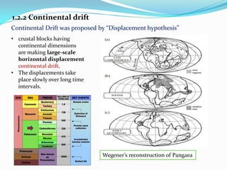
  • 8. 1.2.2 Continental drift Continental Drift was proposed by “Displacement hypothesis” • crustal blocks having continental dimensions are making large-scale horizontal displacement continental drift, • The displacements take place slowly over long time intervals. Wegener’s reconstruction of Pangaea
  • 9. Computer-assisted reconstructions Pangaea Reconstruction The traces of opposite continental margins were matched by an iterative procedure They digitized the continental outlines • approximately 50 km intervals for different depth • (900 m) depth was used for matching
  • 10. Geographical and Magnetic Poles Earth magnetic field (Geomagnetic Field) • points vertically downward in the North Pole • Points vertically upward in the South Pole • Forms earths magnetosphere • Can change polarity over time • caused by electric currents in the liquid outer core Palaeomagnetism and continental drift
  • 11. Palaeomagnetism and continental drift Palaeomagnetism - study of the past record of the direction and intensity of Earth's magnetic (geomagnetic field) field in rocks by oxides of iron (magnetite, hematite, maghemite) when they form. • Magnetic Pole Changes with respect to time
  • 12. (a) In hot lava flows, thermal energy exceeds atomic magnetic exchange energy and the magnetic moments (movements) are randomized. (b) When the lava cools, magnetic moment aligns parallel to the ambient geomagnetic field. (c) When magnetic particles are eroded from a source rock and are deposited as a sediment, the particles may align with the geomagnetic field to give rise to a depositional remanent magnetization (DRM). How rocks acquire a remanent magnetization?
  • 13. Virtual geomagnetic pole (VGP) position –calculation of the position of the magnetic pole at the time in which rocks get magnetised • By connecting mean VGP positions of different ages for sites on the same continent apparent polar wander path is obtain Conclude that poles are not moving but continents are!! Apparent polar wander (APW) -The appearance that the pole has shifted with time • retrace the relative motion of continents, • formation and break-up of supercontinents
  • 14. Earth structure Early in the twentieth century it became evident from the study of seismic waves • interior of the Earth has a radially layered structure • boundaries are marked by abrupt changes in seismic velocity or velocity gradient • Each layer is characterized by composition, pressure and temperature in the layer • Four main layers are the crust, mantle and the outer and inner cores
  • 15. • S waves cannot pass through fluid while P waves can • shadow zone -angular distances of 104 to 140 degrees from a given earthquake that does not receive any direct P waves • Only refracted P waves arrive at position opposite the epicentre How seismic is used to determination of the properties of the Four Layer P and S Waves
  • 16. Depths of the most important seismic discontinuities giving boundaries of layer Inner Core Solid; Radius of Earth 1. Crust 2. Upper Mantle • Lithosphere • Asthenosphere 3. Lower Mental • Mesosphere 4. Outer Core 5. Inner Core
  • 17. Lithospheric plates • Lithosphere- crust and uppermost mantle are rigid, forming a hard outer shell • Asthenosphere- weaker layer may be able to flow over long periods of time like a viscous liquid or plastic solid, • The convection current in the mental causes relative motions of the overlying lithospheric plates • when strongly stressed, fracture happens causing earthquake. Ridge Lithosphere Asthenosphere Trench Trench Ridge This action • resulted in the plate movements • Seismic zones of the earth Earthquakes – is a violent release of elastic energy due to sudden displacement on a fault plane
  • 18. Seismic Belts: (a) the circum-Pacific “ring of fire”; (b) a sinuous belt running from the Azores through North Africa and the Alpine–Dinaride–Himalayan mountain chain as far as S.E. Asia; and (c) the world-circling system of oceanic ridges and rises. Seismic Zones of the Earth
  • 19. Tectonic plates Tectonic plates - fragmented slabs of lithosphere that visible trough boundaries called tectonic plate boundaries. • Sizes range: 1000 - 10,000 sq. km (e.g., the Pacific plate and Philippines plate) • Movement – mm-cm/year • Twelve major plates - (Antarctica, Africa, Eurasia, India, Australia, Arabia, Philippines, North America, South America, Pacific, Nazca, and Cocos) and several minor plates (e.g., Scotia, Caribbean, Juan de Fuca). The seismic zones subdivide the lithosphere laterally into tectonic plates
  • 21. 2. Divergent - two tectonic plates move away from each other Three types of plate boundary (Margins) 3. Transform - Two plates sliding past each other 1. Convergent - two plates come together, Constructive plate margins. Destructive plate margin Conservative plate margin,
  • 22. There are 3 types of Convergent Boundaries… Type 1: Oceanic plate-Continental plate collision • oceanic is more dense and sub duct beneath continental plate • Hot more buoyant material rises • Magmatic arc formation Subduction: The process by which oceanic crust sinks beneath a deep-ocean trench and back into the mantle at a convergent plate boundary.
  • 23. VOLCANOES occur at subduction zones Mountains form at subduction zones
  • 24. Type 2: Ocean plate - Ocean plate collision The less dense plate slides under the more dense plate creating a subduction zone called a TRENCH Oldest will subduct
  • 25. Type 3: Continental plate - Continental plate collision  Neither subduct due to buoyancy of crusts  A place where folded and thrust faulted mountains form.
  • 26. • May form Mountain Ranges. These are Folded Mountains, like the Himalayas
  • 28.  Two plates move apart  Run through ocean basins Divergent Plate Boundaries
  • 29. Mid-oceanic ridges, transform faults and rift valleys, and the formation of the ocean floor are characteristics associated with divergent plate boundaries. Magma
  • 30. Transform Plate Boundary Plate 1 Plate 2 Transform Plate Boundary -two plates slide past one another The fracture zone that forms a transform plate boundary is known as a transform fault
  • 32. Sea-Floor Spreading The process by which molten material adds new oceanic crust to the ocean floor In 1961 R. Dietz term this process “sea-floor spreading” for the ridge process
  • 33. Seafloor spreading formed Mid-Ocean Ridge Mid-Ocean Ridge:  The undersea mountain chain where new ocean floor is produced;  Cause of divergent plate boundary Mid-Ocean Ridge
  • 35. What evidence did scientists find for sea- floor spreading in the 1960s?  Evidence from molten material  Evidence from magnetic stripes  Evidence from drilling samples
  • 36. The Vine–Matthews–Morley hypothesis “When hot lava solidifies and its temperature cools below the Curie temperature of its magnetic minerals, the basalt becomes strongly magnetized in the direction of the Earth’s magnetic field at that time.” Evidence of Magnetic strip
  • 37. Along an active spreading ridge: • basalt form symmetrically on opposite sides of the spreading center, • each carrying the magnetic imprint of the field in which it formed. • Sea-floor spreading can persist for many millions of years at an oceanic ridge. • changes in polarity of different time -ve +ve
  • 38. Evidence From Drilling Samples  When scientists sampled the rocks, they found that the further away from the ridge the rocks were older  The younger rocks were always in the center of the ridges
  • 39. Rates of sea-floor spreading • the opposite sides are moving away from the ridge at equal speeds • increasing slowly at a mean rate of 17mm /yr
  • 40. Computation of half-rates of sea- floor spreading at different spreading centers by measuring the distances to anomalies with known radiometric ages Total spreading rate is twice the half-spreading rate
  • 41. 2. Constructive plate margin- two tectonic plates move away from each other Plate Margins 3. Conservative plate margin - Two plates sliding past each other 1. Destructive plate margin - two plates come together Eg. Divergent boundaries Eg. Convergent boundaries Eg. Transform boundaries
  • 42. Hotspots refer to a long-lasting center of surface volcanism and locally high heat flow rooted in the mantle below the lithosphere • more common in the ocean basins • hot, rising plume • forming a volcanic island • Seamount The motion of the plate transports the island away from the hotspot and the volcanism becomes extinct
  • 43. Example • radiometric dating of basalt samples from islands and seamounts along the Hawaiian Ridge portion of the Hawaiian–Emperor chain
  • 44. Plate motion on the surface of a sphere Earth's surface is a sphere • Made up of Earth's tectonic plates • Plates move continuously with respect to each other, Mathematically speaking, the most general way to describe the motion of rigid plate on a sphere is through rotation about a fixed pole This is known as Euler geometrical theorem
  • 45. This is described in the Euler geometrical theorem, which shows that every displacement of a plate from one position to another on the Earth's surface can be regarded as a simple rotation of that plate about a suitably chosen axis, known as an Euler pole or pole of rotation, which passes through the centre of the Earth. b A Euler pole or pole of rotation
  • 47. Forces driving plate tectonic motions There are forces acting on lithospheric plates that causing the movement of plates • Forces can be driving and resistive Upper mantle convection forces • mantle drag force (𝑭𝑫𝑭) – caused by flow of material beneath a plate on the base of the plate. If convection is fast compare to plate movement. The plate is dragged. Opposite is true. • Continental drag force (𝑭𝑪𝑫) – caused by greater weight of the plate
  • 48. • ridge push force (𝑭𝑹𝑷) – gravitational sliding towards trenches Force at spreading ridges Forces at transform faults • transform force (𝑭𝑻𝑭) - frictional resistance in the contact zone
  • 49. • slab pull force (𝑭𝑺𝑷) – downward pull force of the mantle to the subducting slab • slab resistance force (𝑭𝑺𝑹) – resistance the slab experience as it tries to move further down into mantle Forces at subduction zones Forces at Subduction Zone
  • 50. Forces at Plate collisions • “trench suction” (𝑭𝑺𝑼) – force caused by pull force on the lower plate that pulls the upper plate towards the trench. • collision resistance force (𝑭𝑪𝑹) – opposite motion of colliding plates cause resistance
  • 51. Forces at hotspots • hotspot force (𝐹𝐻𝑆) – caused by transfer of mantle material to the lithosphere
  • 52. Driving Forces are: • slab pull, • slab suction, • ridge push and • trench pull force on the upper plate In Conclusion Resistive Forces are: • slab resistance, • collision resistance, and • transform fault forces.
  • 53. END