


Marine Provinces
- 1. Introduction to Marine Provinces and the Ocean Floor
- 2. 3 major provincesContinental marginsShallow-water areas close to shoreDeep-ocean basinsDeep-water areas farther from landMid-ocean ridgeSubmarine mountain rangeOcean provinces
- 3. Continental MarginsZones separating the part of a continent above sea level from the deep‑sea floor. The true geologic margin of a continent ‑ where continental crust changes to oceanic crust ‑ is somewhere beneath the continental slope.
- 4. Passive Continental MarginPassive Continental Margin ‑ Trailing end of a continental plate. Posses broad continental shelves, a continental slope and rise. Flat abyssal plains are adjacent to the rise. They lack the seismic and volcanic activity.
- 5. Continental marginsActiveAssociated with convergent or transform plate boundariesMuch tectonic activityConvergent active marginOceanic-continental convergenceWhere oceanic lithosphere is subducted. Seismicity, a young Mt. range and andesitic volcanism. The shelf is narrow and descends directly into a trench. Example: western South America
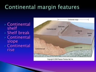
- 6. Continental margin featuresContinental shelfShelf breakContinental slopeContinental rise
- 7. Continental ShelfContinental Shelf ‑ where the sea floor slopes very gently seaward. It ends at a steep drop, the shelf ‑ slope break at @ 135m. In the Pleistocene, sea level was much lower, @ 130m. Much of the sediment on continental shelves accumulated in stream channels and floodplains. Some glaciers extended onto the exposed shelves. Affected by waves and tidal currents.
- 8. Continental slopeChange in gradient from shelf Average gradient 4oSubmarine canyonscut into slope by turbidity currentsMixture of seawater and sedimentsMove under influence of gravityErode canyonsDeposit sediments at base of slope
- 9. Turbidity CurrentsTurbidity Currents ; sediment‑ water mixture denser than normal seawater Flow down‑slope to the deep‑sea floor. Coarsest particles are deposited first ‑ forming a graded bed. Deposits accumulate as a series of overlapping submarine fans, forming a large part of the continental rise.
- 10. Continental RiseContinental rise ‑ gently sloping area from the slope to a trench. Unaffected by surface processes and transport is controlled by gravity. Where most of the sediments are eventually deposited. Much of the sediment is transported by turbidity currents. Deep ocean Basin ‑ seaward of the continental margin.
- 11. Submarine CanyonsDeep, steep sided submarine canyons occur on continental shelves, but are best developed on the continental slopes. Some Canyons can be traced across the shelf to associated streams on land. Some can not. Strong currents move through these canyons and are probably responsible for their erosion.Monterey Submarine Canyon
- 12. Continental riseTransition between continental crust and oceanic crustTurbidite depositsGraded beddingSubmarine fansDistal end of submarine fans becomes flat abyssal plains
- 13. Submarine fansThe product of turbidity currents in km water depthPresent/future targets of the oil industry onceshallower resources are exhausted
- 14. Abyssal PlainsFlat abyssal plains are adjacent to the rise. They lack the seismic and volcanic activity. Abyssal Plains are the flattest, most featureless areas of Earth A result of sediment deposition.Found adjacent to Continental rises.Common in the Atlantic, rare in the Pacific.Along active margins, sediments are trapped in an ocean trench so abyssal fans fail to develop.
- 15. Abyssal plainsVery flat depositional surfaces from base of continental riseSuspension settlingof very fine particlesSediments cover ocean crust irregularitiesWell-developed in Atlantic and Indian oceans
- 16. Abyssal Hills / PlainsAbyssal hills ‑ average @ 250m high. They are common on the sea floor and underlie thick sediments on the abyssal plains.
- 18. Oceanic TrenchesOceanic TrenchesWhere lithospheric plates are consumed by subduction.Long, narrow features restricted to active continental margins.Oceanic trenches are the sites of greatest oceanic depth.Marianas Trench : 11,000 m deep.The crust here is cooler and slightly denser than elsewhere.
- 19. Ocean TrenchesTrenches show a huge negative gravity anomaly; The crust is held down and is not in equilibrium.Seismic activity occurs at or near the trenches. They have Benioff zones in which earthquake foci become progressively deeper in a landward direction. Most intermediate and deepearthquakes occur in such zones.They are associated with volcanoes. (W. So. America)
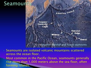
- 20. SeamountsEmperor, Marshall and Hawaii seamountsSeamounts are isolated volcanic mountains scattered across the ocean floor. Most common in the Pacific Ocean, seamounts generally rise more than 1,000 meters above the sea floor, often forming islands.
- 21. SeamountsWhen the action of plate tectonics moves a seamount-formed island away from the mid-ocean ridge, the ocean crust sinks, pulling the island beneath the surface. These submerged, often flat-topped, seamounts are called guyots.
- 22. Volcanic peaksPoke through sediment coverBelow sea level:Seamounts, tablemounts, or guyotsat least 1 km (0.6 m) above sea floorAbyssalhills orseaknollsare less than 1 kmAbove sea level:Volcanic islands
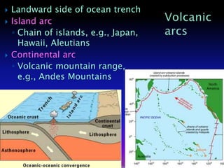
- 23. Landward side of ocean trenchIsland arcChain of islands, e.g., Japan, Hawaii, AleutiansContinental arcVolcanic mountain range, e.g., Andes MountainsVolcanic arcs
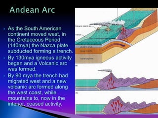
- 24. Andean ArcAs the South American continent moved west, in the Cretaceous Period (140mya) the Nazca plate subducted forming a trench.By 130mya igneous activity began and a Volcanic arc was formed.By 90 mya the trench had migrated west and a new volcanic arc formed along the west coast, while mountains to, now in the interior, ceased activity.
- 25. Mid-ocean ridge Longest mountain chainOn average, 2.5 km (1.5 miles) above surrounding sea floorWholly volcanicBasaltic lavaDivergent plate boundaryCentral rift valley, faults, and fissuresSeamountsPillow basaltsHydrothermal ventsDeposits of metal sulfidesUnusual life formsFracture zones and transform faults
- 26. Mid-ocean ridge featuresOceanic ridgeProminent rift valleySteep, rugged slopesExample: Mid-Atlantic RidgeOceanic riseGentler, less rugged slopesExample: East Pacific Rise
- 27. Pillow lava / Pillow basaltWhen lava flows enter the ocean, or when lava outpourings actually originate within an ocean basin, the flows outer zones quickly congeal. The lava within the flow is able to move forward by breaking through the hardened surface, when this occurs over and over.The lava flow resembles large bed pillows stacked one upon another.
- 28. Hydro‑thermal Vents1970'S @ 2,500m in the Galapagos Rift in E. Pacific Ocean Basin hydro‑thermal vents were first observed. ALVIN: Woods Hole Submersible
- 29. Volcanic features of mid-ocean ridgeHydrothermal ventsHeated subsurface seawater migrates through cracks in ocean crustWarm-water vents <30oC or 86oFWhite smokers >30oC <350oC or 662oFBlack smokers > 350oC