Mohammed kareem
- 1. Height of Collimation method Mohammed Kareem
- 2. Leveling :- is the process used to determine a difference in elevation between two points. A Level is an instrument with a telescope that can be leveled with a spirit bubble. The optical line of sight forms a horizontal plane, which is at the same elevation as the telescope crosshair. By reading a graduated rod held vertically on a point of known elevation (Bench Mark) a difference in elevation can be measured and a height of instrument (H.I.) calculated by adding the rod reading to the elevation of the bench mark. Once the height of instrument is established, rod readings can be taken on subsequent points and their elevations calculated by simply subtracting the readings from the height of instrument.
- 4. Devices are classified leveling in terms of accuracy into three categories: 1 - Precision: the settlement where the bubble is very sensitive as are high magnification power and uses this type of work and Geodetic Survey businesses that require high precision. 2 - Precision medium: It is less accurate than the first category and dominated the use of this type in most engineering projects. 3 - low-precision devices: and make this kind of hardware specifically for the purposes of settlement approximate as in building projects Ltd. and settlement cases within short distance.
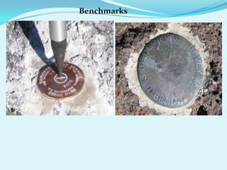
- 5. Datum line ( M.S.L. ) :- Is the level (line), which are attributed to it points levels on the surface of the Earth. Which is the average sea level. Reduced level ( R.L) :- Is the high point from datum line. Benchmark (B .M ) :- Are fixed points information site and attributed placed in different places until you start racing them when conducting settlement . Back sight ( B.S.) :- Is the first reading taken after placing the device in any position so that we see the greatest possible number of points required to find the elevation . Fore sight (F.S) :- Is the last reading taken before the transfer device
- 6. Benchmarks
- 7. Intermediate sight ( I.S.) :- Is reading taken between the back sight and fore sight reading . Elevation of line of sight ( H.I) :- Is the imaginary vertical level determined by the line of sight to the amount of increase or decrease for sea level . Tripod :- is a portable three-legged frame, used as a platform for supporting the weight and maintaining the stability of some other object (( plumb bob))
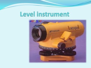
- 8. tripod A level is an instrument giving horizontal line of sight and magnifying the reading at a far away distance. It consists of the following parts: (i) A telescope to provide a line of sight (ii) A level tube to make the line of sight horizontal and (iii) A leveling head to level the instrument
- 10. Staff :-Is a wooden or metal ruler one side runway to meters and centimeters. And is a ruler of solid wood 2 , 3 , 4 , 5 meters in length and usually 4 meters .
- 11. Leveling of the instrument is done to make the vertical axis of the instrument truly vertical. It is achieved by carrying out the following steps: Step 1: The level tube is brought parallel to any two of the foot screws, by rotating the upper part of the instrument. Step 2: The bubble is brought to the centre of the level tube by rotating both the foot screws either inward or outward. (The bubble moves in the same direction as the left thumb.) Step 3: The level tube is then brought over the third foot screw again by rotating the upper part of the instrument. Step 4: The bubble is then again brought to the centre of the level tube by rotating the third foot screw either inward or outward.
- 12. Step 8: By rotating the upper part of the instrument through 180 ° , the level tube is brought parallel to first two foot screws in reverse order. The bubble will remain in the centre if the instrument is in permanent adjustment.
- 14. Method of taking readings on a ruler settlement 1 – direct leveling a back sight is taken on the rod held at the bench mark ( A ) . H..I = E.L.V of B.M. ( A ) + B.S. Turning the telescope to bring into view the rod held on point B afore sight is taken . elev. Point B = H .I – F .S check the work by the following equation :- ∑ B.S. - ∑ F.S. = Last R.L. – First R.L.
- 15. Closing the Level Loop A level loop is closed either to another Benchmark or back to the starting Benchmark. To check for errors in the loop sum the Back sights (BS) and the Foresights (FS). Calculate the difference between the BS and FS (BSFS). Algebraically add this difference to the starting elevation, to yield the closing elevation. This elevation should be within accepted industry standards tolerances of the closing Benchmark’s published elevation.
- 16. Height of Collimation method
- 17. Azimuth:- The azimuth of a line on the ground is its horizontal angle measured from the meridian to the line. In plane surveying, azimuths are generally measured from the north. Azimuths may have values between 0 and 360 degrees.
- 18. Bearings :- The bearing states whether the angle is measured from the north or the south and also whether the angle is measured toward the east or west. For example, if a line has a bearing of S 47° E, the bearing angle 47° is measured from the south meridian eastward.
- 20. N.E. Quadrant: Bearing equals Azimuth S.E. Quadrant: 180° -Azimuth = Bearing and 180° - Bearing = Azimuth S.W. Quadrant: Azimuth - 180° = Bearing and Bearing + 180° = Azimuth N.W. Quadrant: 360° -Azimuth = Bearing and 360° - Bearing = Azimuth


