Location via proxy:   [ UP ]  
[Report a bug]   [Manage cookies]                
SlideShare a Scribd company logo
Revised draft Local Plan
Transport
July 2017
DELIVERY & IMPLEMENTATION
DEVELOPMENT MANAGEMENT POLICIES
PLACES
STRATEGIC POLICIES
SPATIAL VISION
INTRODUCTION
New evidence base and
responses to consultation
DELIVERY & IMPLEMENTATION
THEMATIC POLICIES
PLACES
OVERARCHING SPATIAL POLICIES
SPATIAL VISION & OBJECTIVES
INTRODUCTION
REGULATION 18
REGULATION 19
Old and new structure
SP7: CONNECTING PEOPLE AND
PLACES
CHAPTER 7: TRANSPORT
T1: Roads and Streets
T2: Walking
T3: Cycling
T4: Parking
T5: Rail
T6: Buses
T7: Freight, servicing and deliveries
T8: Construction
T9: Transport Assessments and Travel
Plans
DELIVERY & IMPLEMENTATION
DEVELOPMENT MANAGEMENT POLICIES
PLACES
STRATEGIC POLICIES
SPATIAL VISION
INTRODUCTION
Existing and new evidence base
REGULATION 19
Local Plan focus
• Minimising traffic congestion
• Support and objections to stringent
Car Parking controls
• Cycle parking
• Delivering pedestrian and cycle
friendly streets
• Tackling construction and
freight issues
Key issues
• A40 Study
• Bus Strategy
• Car Parking Study
• Infrastructure Delivery Plan
• North Acton Station Feasibility
Study
• Old Oak Strategic Transport
Study
• Park Royal Transport Strategy
• Public Realm, Walking and
Cycling Strategy
• Willesden Junction Station
Feasibility Study
Supporting Studies
Supporting Studies – key overview
Park Royal Transport Strategy
Strategic assessment of the existing
transport provision in Park Royal,
the impact of the planned future
growth and identification of the
transport interventions required to
mitigate those impacts.
Infrastructure Delivery Plan
Identifies the infrastructure
required to support the
regeneration of the area.
North Acton Station Feasibility
Study
Investigates the options for
enhancing the capacity and
accessibility of North Acton station
and the options for improving the
permeability of the site.
Bus Strategy
Shows how the current bus network
could be adjusted to deliver the best
outcome with regards to optimising
the bus network to unlock Old Oak
and Park Royal.
Old Oak Strategic Transport
Study
Strategic assessment of the
existing transport provision in Old
Oak, the impact of the planned
future growth and identification of
the transport interventions
required to mitigate those
impacts.
Public Realm, Walking and
Cycling Strategy
Provides a framework for delivering
an exemplar sustainable,
accessible urban environment for
Old Oak and Park Royal with high
quality public realm and where
walking and cycling are
comfortable, convenient, safe and
efficient choices for people to move
around the local area.
Car Parking Study
Provides a critical review of the
proposed parking policy in the Local
Plan from a market and viability
perspective.
A40 Study
This study identified the key
challenges associated with the
A40 and investigated potential
long term investment options.
Willesden Junction Station
Feasibility Study
Feasibility study on Willesden
Junction Station and Interchange to
GRIP 2 level.
Connecting People and Places
• Creating or contributing to a high quality, safe and accessible
movement network
Proposed connections
EVIDENCE BASE STUDIES:
- Environmental Standards Study
- Infrastructure Delivery Plan
- Old Oak Strategic Transport Study
- Park Royal Transport Strategy
- Public Realm, Walking and Cycling Strategy
T1: Roads and Streets
• Deliver against ten healthy streets
indicators
• Provide a range of new streets that
help overcome severance and
optimise connectivity
• Enhance existing streets to mitigate
the impacts of development on the
surrounding local and strategic
road network
• Promote effective and integrates
management of streets to future-proof
for changes in the surrounding
context, as well as life-style and
technological changes
Affordable
Housing
Viability
Assessment
T2: Walking
EVIDENCE BASE STUDIES:
- Environmental Standards Study
- Infrastructure Delivery Plan
- Old Oak Strategic Transport Study
- Park Royal Transport Strategy
- Public Realm, Walking and Cycling Strategy
• Deliver new walking routes to enable
the delivery of a high quality, safe,
direct, accessible and inclusive
walking network
• Provide new and enhance existing
walking infrastructure
• Connect to existing and planned
pedestrian links in the wider area
• Contribute to the network of Legible
London signs to improve legibility and
wayfinding in Old Oak and Park Royal
Affordable
Housing
Viability
Assessment
Affordable
Housing
Viability
Assessment
T2: Walking
Affordable Housing
Viability Assessment
T3: Cycling
EVIDENCE BASE STUDIES:
- Environmental Standards Study
- Infrastructure Delivery Plan
- Park Royal Transport Strategy
- Public Realm, Walking and Cycling Strategy
• New and enhanced cycle routes
within and to Old Oak and Park Royal
• Improved cycling connections to
stations
• Contribute towards signage to
improve cycle wayfinding and legibility
• Require high quality, secure, well
located, convenient and accessible
parking facilities that exceed the
standards set out in the London Plan
• Contribute towards the provision of
cycle hire in Old Oak and Park Royal
Affordable Housing
Viability Assessment
T3: Cycling
Affordable Housing
Viability Assessment
EVIDENCE BASE STUDIES:
• Car Parking Study
• Environmental Standards Study
• Infrastructure Delivery Plan
• Old Oak Strategic Transport Study
• Park Royal Transport Strategy
T4: Parking
• Strongly encourage car-free
development within PTALs 4-6b
• 0.2 spaces per residential unit
elsewhere
• Car- free for non-residential
developments, but recognises there
may be cases where limited car
parking can be justified
• Ensure car parking is well-designed
• Electric vehicle charging (20% active,
80% passive)
• Car clubs encouraged
Affordable Housing
Viability Assessment
Current Public Transport Accessibility Levels
Affordable Housing
Viability Assessment
Future Public Transport Accessibility Levels
T5: Rail
EVIDENCE BASE STUDIES:
• Infrastructure Delivery Plan
• Old Oak Strategic Transport Study
• Park Royal Transport Strategy
• Willesden Junction Station Feasibility Study
• North Acton Station Feasibility Study
• Improving existing and delivering
new rail stations
• design new rail stations to deliver
outstanding design quality and enable future proofing of station design
to facilitate future technological advances, rail connections and
service changes
• include the provision of retail, culture, leisure, town centre and
meanwhile uses
• manage the demands of competing transport modes and interchange
requirements for walking, cycling, buses and taxis
• provide step free access from all entrances to platforms
• optimise development opportunities on and/or adjacent to the stations
and tracks
• ensure new rail infrastructure is
sensitively designed to integrate with
surrounding development
T5: Rail
Transport connections
• 2026 Old Oak station opens with: HS2,
Elizabeth Line (Crossrail) and the Great
Western Mainline
• 250,000 passengers per day
• 90% the size of Waterloo station
• 8 min from central London
• 10 min from Heathrow
• 38 min from Birmingham
Old Oak Common Station
The site of the largest sub-surface
station to be built in the UK
Proposed HS2 Hybrid Bill design
Willesden Junction Station
GRIP 2 Study - complete
Identified three potential
options for future and
capacity issues today.
North Acton Station
Pre-feasibility study – complete
Indicated need for station
improvements and capacity
enhancements now.
New Hythe Road and Old
Oak Common Lane
Stations
GRIP 3 Study – in
progress
Identified viaduct and
footbridge solutions.
Required to alleviate
capacity at on Crossrail
and at Euston.
Known capacity issues on
NLL and WLL.
Old Oak Common Station
Influencing DfT and HS2 Ltd to
improve the design of the HS2
Station
Rail work to date
24
Willesden Junction Station
North Acton Station
OVERGROUNDLondon Overground stations
EVIDENCE BASE STUDIES:
• Bus Strategy
T6: Buses
• Enhance existing and provide new bus
infrastructure
• Ensure that all residents in Old Oak and Park
Royal live within 400m of high quality,
convenient, safe, sheltered and personally
secure passenger waiting and information
countdown facilities
• Design streets to be served by buses
• Ensure that impacts to bus operations
resulting from construction activity
are mitigated
• Provide temporary provision for
buses, during the phased
development of the OPDC area
• Support the roll out of low and zero
emission buses
Affordable Housing
Viability Assessment
T6: Buses
EVIDENCE BASE STUDIES:
• Circular Economy Study
• Old Oak Transport Study
• Park Royal Transport Strategy
T7: Freight, Servicing & Deliveries
• Reduce freight and servicing trips
through forecasting, requiring Servicing
and Delivery Plans and through
consolidation centres
• Provide off-street servicing facilities
• Click and collect
• Make use of rail and water for freight
• Ensure that the operators of all freight
vehicles operating in the area have
attained the Silver Fleet Operator
Recognition Scheme (FORS)
accreditation
• Support and enable smart technologies
EVIDENCE BASE STUDIES:
• Circular and Sharing Economy Study
• Old Oak Transport Study
• Park Royal Transport Strategy
T8: Construction
• Reduce construction trips through
 forecasting
 requiring the production and implementation
of Construction Logistics Plan and
Construction Code of Practice
 Utilising consolidation centres
• Coordinate construction with adjacent projects to
minimise trips
• Make use of rail and water for movement of
construction materials
• Ensure that the operators of all freight vehicles
operating in the area have attained the Silver
Fleet Operator Recognition Scheme (FORS)
accreditation
• Deliver measures to ensure safety of
pedestrians and cyclists
Affordable Housing
Viability Assessment
Affordable Housing
Viability Assessment
EVIDENCE BASE STUDIES:
• Public Realm, walking and cycling study
• Old Oak Transport Study
• Park Royal Transport Strategy
T9: Transport Assessment and Travel Plans
• Transport assessments and travel
plans should be provided for
planning applications exceeding
the thresholds in, and produced in
accordance with the relevant TfL
guidance
Consultation details
Key issues
• Public consultation on the revised draft Local Plan concludes:
midnight Monday 11 September 2017
• Autumn 2017: OPDC considers consultation responses and make
necessary amendments to the Local Plan
• Early 2018: Submit to Secretary of State
• Spring 2018: Examination in Public
• Summer 2018: Adopt Local Plan
Next steps
@oldoakparkroyal #OPDClocalplan
www.bit.ly/OPDCReg19
localplan@opdc.london.gov.uk
020 7983 5552

More Related Content

OPDC revised draft Local Plan presentation - Transport

  • 1. Revised draft Local Plan Transport July 2017
  • 2. DELIVERY & IMPLEMENTATION DEVELOPMENT MANAGEMENT POLICIES PLACES STRATEGIC POLICIES SPATIAL VISION INTRODUCTION New evidence base and responses to consultation DELIVERY & IMPLEMENTATION THEMATIC POLICIES PLACES OVERARCHING SPATIAL POLICIES SPATIAL VISION & OBJECTIVES INTRODUCTION REGULATION 18 REGULATION 19 Old and new structure
  • 3. SP7: CONNECTING PEOPLE AND PLACES CHAPTER 7: TRANSPORT T1: Roads and Streets T2: Walking T3: Cycling T4: Parking T5: Rail T6: Buses T7: Freight, servicing and deliveries T8: Construction T9: Transport Assessments and Travel Plans DELIVERY & IMPLEMENTATION DEVELOPMENT MANAGEMENT POLICIES PLACES STRATEGIC POLICIES SPATIAL VISION INTRODUCTION Existing and new evidence base REGULATION 19 Local Plan focus
  • 4. • Minimising traffic congestion • Support and objections to stringent Car Parking controls • Cycle parking • Delivering pedestrian and cycle friendly streets • Tackling construction and freight issues Key issues
  • 5. • A40 Study • Bus Strategy • Car Parking Study • Infrastructure Delivery Plan • North Acton Station Feasibility Study • Old Oak Strategic Transport Study • Park Royal Transport Strategy • Public Realm, Walking and Cycling Strategy • Willesden Junction Station Feasibility Study Supporting Studies
  • 6. Supporting Studies – key overview Park Royal Transport Strategy Strategic assessment of the existing transport provision in Park Royal, the impact of the planned future growth and identification of the transport interventions required to mitigate those impacts. Infrastructure Delivery Plan Identifies the infrastructure required to support the regeneration of the area. North Acton Station Feasibility Study Investigates the options for enhancing the capacity and accessibility of North Acton station and the options for improving the permeability of the site. Bus Strategy Shows how the current bus network could be adjusted to deliver the best outcome with regards to optimising the bus network to unlock Old Oak and Park Royal. Old Oak Strategic Transport Study Strategic assessment of the existing transport provision in Old Oak, the impact of the planned future growth and identification of the transport interventions required to mitigate those impacts. Public Realm, Walking and Cycling Strategy Provides a framework for delivering an exemplar sustainable, accessible urban environment for Old Oak and Park Royal with high quality public realm and where walking and cycling are comfortable, convenient, safe and efficient choices for people to move around the local area. Car Parking Study Provides a critical review of the proposed parking policy in the Local Plan from a market and viability perspective. A40 Study This study identified the key challenges associated with the A40 and investigated potential long term investment options. Willesden Junction Station Feasibility Study Feasibility study on Willesden Junction Station and Interchange to GRIP 2 level.
  • 7. Connecting People and Places • Creating or contributing to a high quality, safe and accessible movement network
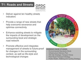
  • 9. EVIDENCE BASE STUDIES: - Environmental Standards Study - Infrastructure Delivery Plan - Old Oak Strategic Transport Study - Park Royal Transport Strategy - Public Realm, Walking and Cycling Strategy T1: Roads and Streets • Deliver against ten healthy streets indicators • Provide a range of new streets that help overcome severance and optimise connectivity • Enhance existing streets to mitigate the impacts of development on the surrounding local and strategic road network • Promote effective and integrates management of streets to future-proof for changes in the surrounding context, as well as life-style and technological changes
  • 10. Affordable Housing Viability Assessment T2: Walking EVIDENCE BASE STUDIES: - Environmental Standards Study - Infrastructure Delivery Plan - Old Oak Strategic Transport Study - Park Royal Transport Strategy - Public Realm, Walking and Cycling Strategy • Deliver new walking routes to enable the delivery of a high quality, safe, direct, accessible and inclusive walking network • Provide new and enhance existing walking infrastructure • Connect to existing and planned pedestrian links in the wider area • Contribute to the network of Legible London signs to improve legibility and wayfinding in Old Oak and Park Royal
  • 12. Affordable Housing Viability Assessment T3: Cycling EVIDENCE BASE STUDIES: - Environmental Standards Study - Infrastructure Delivery Plan - Park Royal Transport Strategy - Public Realm, Walking and Cycling Strategy • New and enhanced cycle routes within and to Old Oak and Park Royal • Improved cycling connections to stations • Contribute towards signage to improve cycle wayfinding and legibility • Require high quality, secure, well located, convenient and accessible parking facilities that exceed the standards set out in the London Plan • Contribute towards the provision of cycle hire in Old Oak and Park Royal
  • 14. Affordable Housing Viability Assessment EVIDENCE BASE STUDIES: • Car Parking Study • Environmental Standards Study • Infrastructure Delivery Plan • Old Oak Strategic Transport Study • Park Royal Transport Strategy T4: Parking • Strongly encourage car-free development within PTALs 4-6b • 0.2 spaces per residential unit elsewhere • Car- free for non-residential developments, but recognises there may be cases where limited car parking can be justified • Ensure car parking is well-designed • Electric vehicle charging (20% active, 80% passive) • Car clubs encouraged
  • 15. Affordable Housing Viability Assessment Current Public Transport Accessibility Levels
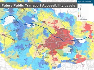
  • 16. Affordable Housing Viability Assessment Future Public Transport Accessibility Levels
  • 17. T5: Rail EVIDENCE BASE STUDIES: • Infrastructure Delivery Plan • Old Oak Strategic Transport Study • Park Royal Transport Strategy • Willesden Junction Station Feasibility Study • North Acton Station Feasibility Study • Improving existing and delivering new rail stations • design new rail stations to deliver outstanding design quality and enable future proofing of station design to facilitate future technological advances, rail connections and service changes • include the provision of retail, culture, leisure, town centre and meanwhile uses • manage the demands of competing transport modes and interchange requirements for walking, cycling, buses and taxis • provide step free access from all entrances to platforms • optimise development opportunities on and/or adjacent to the stations and tracks • ensure new rail infrastructure is sensitively designed to integrate with surrounding development
  • 20. • 2026 Old Oak station opens with: HS2, Elizabeth Line (Crossrail) and the Great Western Mainline • 250,000 passengers per day • 90% the size of Waterloo station • 8 min from central London • 10 min from Heathrow • 38 min from Birmingham Old Oak Common Station
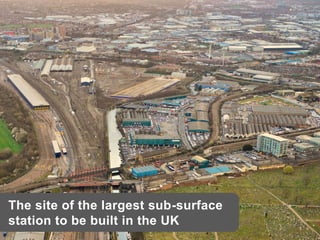
  • 21. The site of the largest sub-surface station to be built in the UK
  • 22. Proposed HS2 Hybrid Bill design
  • 23. Willesden Junction Station GRIP 2 Study - complete Identified three potential options for future and capacity issues today. North Acton Station Pre-feasibility study – complete Indicated need for station improvements and capacity enhancements now. New Hythe Road and Old Oak Common Lane Stations GRIP 3 Study – in progress Identified viaduct and footbridge solutions. Required to alleviate capacity at on Crossrail and at Euston. Known capacity issues on NLL and WLL. Old Oak Common Station Influencing DfT and HS2 Ltd to improve the design of the HS2 Station Rail work to date
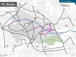
  • 27. EVIDENCE BASE STUDIES: • Bus Strategy T6: Buses • Enhance existing and provide new bus infrastructure • Ensure that all residents in Old Oak and Park Royal live within 400m of high quality, convenient, safe, sheltered and personally secure passenger waiting and information countdown facilities • Design streets to be served by buses • Ensure that impacts to bus operations resulting from construction activity are mitigated • Provide temporary provision for buses, during the phased development of the OPDC area • Support the roll out of low and zero emission buses
  • 29. EVIDENCE BASE STUDIES: • Circular Economy Study • Old Oak Transport Study • Park Royal Transport Strategy T7: Freight, Servicing & Deliveries • Reduce freight and servicing trips through forecasting, requiring Servicing and Delivery Plans and through consolidation centres • Provide off-street servicing facilities • Click and collect • Make use of rail and water for freight • Ensure that the operators of all freight vehicles operating in the area have attained the Silver Fleet Operator Recognition Scheme (FORS) accreditation • Support and enable smart technologies
  • 30. EVIDENCE BASE STUDIES: • Circular and Sharing Economy Study • Old Oak Transport Study • Park Royal Transport Strategy T8: Construction • Reduce construction trips through  forecasting  requiring the production and implementation of Construction Logistics Plan and Construction Code of Practice  Utilising consolidation centres • Coordinate construction with adjacent projects to minimise trips • Make use of rail and water for movement of construction materials • Ensure that the operators of all freight vehicles operating in the area have attained the Silver Fleet Operator Recognition Scheme (FORS) accreditation • Deliver measures to ensure safety of pedestrians and cyclists
  • 31. Affordable Housing Viability Assessment Affordable Housing Viability Assessment EVIDENCE BASE STUDIES: • Public Realm, walking and cycling study • Old Oak Transport Study • Park Royal Transport Strategy T9: Transport Assessment and Travel Plans • Transport assessments and travel plans should be provided for planning applications exceeding the thresholds in, and produced in accordance with the relevant TfL guidance
  • 33. Key issues • Public consultation on the revised draft Local Plan concludes: midnight Monday 11 September 2017 • Autumn 2017: OPDC considers consultation responses and make necessary amendments to the Local Plan • Early 2018: Submit to Secretary of State • Spring 2018: Examination in Public • Summer 2018: Adopt Local Plan Next steps