Location via proxy:   [ UP ]  
[Report a bug]   [Manage cookies]                
SlideShare a Scribd company logo
Based on the findings of the paper
“Digital elevation based flood hazard and
vulnerability study at various return periods in
Sirajganj Sadar Upazila, Bangladesh”
by Sadequr Rahman Bhuiyan et al (2014).
Md Asif Hasan
• Bangladesh is a low-laying deltaic country with big inland
water bodies, including some of the biggest rivers in the
world. It is extremely vulnerable to flooding because of its
geographical setting.
• Flooding is an annual recurring event during monsoon and
80% of the annual rainfall occurs in monsoon. Due to
intense rainfall during monsoon (June to September),
about one-fifth to one-third of the country is annually
flooded by overflowing rivers caused by heavy rainfall.
Sirajganj is extremely flood prone area of
Bangladesh. The objective of the study is-
• To produce Flood hazard Map
• Crops and settlement vulnerability
assessment
• To identify the potential areas for flood
mitigation
Fig: Study Area
Sirajgang flood
Fig: Land Use and land cover map of the study area (2014)
• In the study, inundated areas are defined into four
qualitative hazard classes based on the inundation depth.
 Low Hazard(0 - 2 m)
 Medium Hazard (2.1–5.0m)
 High Hazard (5.1–10.0m)
 Very High (410 m)
Sirajgang flood
• The flood affected area increases
with the increase of return period
and flood depth.
• In this study, for 100 year return
period, 46.10% (144.98 sq km) area
has been founded flooding
• Inundated areas become doubled
for land use classes of agriculture
and rural settlement with the
increase of return periods.
• Rural settlement areas are
inundated much more than that of
urban settlement with the increase
of return period and flood depth.
• Water bodies become inundated
much more than that of any other
classes of land use, most of the
area are located in medium to very
high hazard area.
Fig: 100 year return period corps vulnerability map
Crop vulnerability mapping
Crops and settlement vulnerability map has been
developed using the different flood magnitude. In
the crops vulnerability mapping, crops
vulnerability value is defined into five qualitative
classes-
 Very low vulnerability (0-0.5)
 Low vulnerability (0.5–0.6)
 Moderate vulnerability(0.6–0.7)
 High Vulnerability(0.7–0.9)
 Very high vulnerability(0.9–1.0)
Most of the crops vulnerable areas are founded in
low land area
Fig: Crop Vulnerability Function
Fig: 100 year return period settlement vulnerability map
Settlement vulnerability mapping
In the settlement vulnerability mapping, the
vulnerability value is defined into five qualitative
classes
 Very Low vulnerability(0- 0.1),
 Low vulnerability(0.1–0.3),
 Moderate vulnerability(0.30–0.6),
 High Vulnerability (0.6–0.7)
 Very high vulnerability(0.7–1.0).
Very Low, low, moderate, high and very high
vulnerability indicates maximum 10%, 30%, 60%,
70% and more than 70% damage of the
respective settlement.
Sirajgang flood

More Related Content

Sirajgang flood

  • 1. Based on the findings of the paper “Digital elevation based flood hazard and vulnerability study at various return periods in Sirajganj Sadar Upazila, Bangladesh” by Sadequr Rahman Bhuiyan et al (2014). Md Asif Hasan
  • 2. • Bangladesh is a low-laying deltaic country with big inland water bodies, including some of the biggest rivers in the world. It is extremely vulnerable to flooding because of its geographical setting. • Flooding is an annual recurring event during monsoon and 80% of the annual rainfall occurs in monsoon. Due to intense rainfall during monsoon (June to September), about one-fifth to one-third of the country is annually flooded by overflowing rivers caused by heavy rainfall.
  • 3. Sirajganj is extremely flood prone area of Bangladesh. The objective of the study is- • To produce Flood hazard Map • Crops and settlement vulnerability assessment • To identify the potential areas for flood mitigation Fig: Study Area
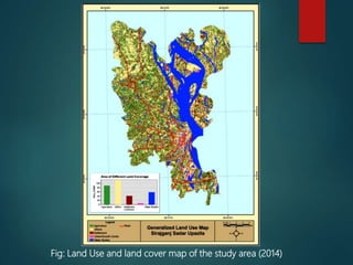
  • 5. Fig: Land Use and land cover map of the study area (2014)
  • 6. • In the study, inundated areas are defined into four qualitative hazard classes based on the inundation depth.  Low Hazard(0 - 2 m)  Medium Hazard (2.1–5.0m)  High Hazard (5.1–10.0m)  Very High (410 m)
  • 8. • The flood affected area increases with the increase of return period and flood depth. • In this study, for 100 year return period, 46.10% (144.98 sq km) area has been founded flooding • Inundated areas become doubled for land use classes of agriculture and rural settlement with the increase of return periods. • Rural settlement areas are inundated much more than that of urban settlement with the increase of return period and flood depth. • Water bodies become inundated much more than that of any other classes of land use, most of the area are located in medium to very high hazard area.
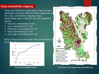
  • 9. Fig: 100 year return period corps vulnerability map Crop vulnerability mapping Crops and settlement vulnerability map has been developed using the different flood magnitude. In the crops vulnerability mapping, crops vulnerability value is defined into five qualitative classes-  Very low vulnerability (0-0.5)  Low vulnerability (0.5–0.6)  Moderate vulnerability(0.6–0.7)  High Vulnerability(0.7–0.9)  Very high vulnerability(0.9–1.0) Most of the crops vulnerable areas are founded in low land area Fig: Crop Vulnerability Function
  • 10. Fig: 100 year return period settlement vulnerability map Settlement vulnerability mapping In the settlement vulnerability mapping, the vulnerability value is defined into five qualitative classes  Very Low vulnerability(0- 0.1),  Low vulnerability(0.1–0.3),  Moderate vulnerability(0.30–0.6),  High Vulnerability (0.6–0.7)  Very high vulnerability(0.7–1.0). Very Low, low, moderate, high and very high vulnerability indicates maximum 10%, 30%, 60%, 70% and more than 70% damage of the respective settlement.