Location via proxy:   [ UP ]  
[Report a bug]   [Manage cookies]                
SlideShare a Scribd company logo
Former NAS Moffett Field


Site 28 Supplemental Investigation
              Neil Hey, PG
            Shaw E & I, Inc.
                    &
             Valerie Harris, PE
        Remedial Project Manager
          Navy BRAC PMO West


              RAB Meeting
            February 7, 2013
Presentation Overview


 Project Objectives
 Technical Approach
 Preliminary Results
 Remaining Work
 Questions


                       2
3
Site 28 Supplemental Investigation
Project Objectives


Supplemental investigation is needed to:
   1) Further delineate PCE & daughter products (TCE,
      DCE, & VC) in A-aquifer within & around the Former
      Building 88 & Traffic Island source areas
   2) Confirm depth & lateral continuity of A/B-aquitard in
      Traffic Island Area
   3) Verify depth to top of B2-aquifer in Traffic Island
      Area
   4) Confirm whether existing well W-88-1 is screened in
      B2-aquifer
   5) Confirm whether B2-aquifer beneath Traffic Island
      Area is impacted by COCs

                              5
Technical Approach


Phase 1 – Semi-quantitative Screening
Survey
  To further assess the distribution of CEs and
  soil lithology in the areas of interest

Phase 2 – Monitoring Well Installations &
Sampling
  To fill in data gaps of the current groundwater
  monitoring well network

                        6
Navy SCAPS Rig


       7
SCAPS Probe


              From:
              U.S. Army Corps of Engineers, 2002,
              Cost and Performance Report for Tri-Service
              SCAPS MIP, January , ERDC/EL TR-02-1


     8
MIP/DSITMS System


Membrane interface probe (MIP)/ Direct sample ion-trap
mass spectrometer (DSITMS) detector System
      Semi-quantitative COC concentration data
       (mg/L of calibration solution)
      MIP data are only considered estimates
       (USACE, 2002)
   <http://el.erdc.usace.army.mil/elpubs/pdf/trel02-1.pdf>

      Results by MIP system are relative & should be
       verified by soil and groundwater samples
       (EPA, 2012)
   <http://www.clu-in.org/characterization/technologies/mip.cfm>


                              9
SCAPS Test Results – Former Bldg 88


General
                                                         Tier 1 SCAPS test location
Groundwater
Flow Direction                                           Tier 2 SCAPS test location

                                                     µg/Lcs denotes micrograms per
                                                     liter of DSITMS calibration solution


   11.1 ft bgs
   210,000 µg/Lcs – MIP
   440 µg/L - GW                                         Maximum MIP/DSITMS
                              11.5 ft bgs
   0.45 mg/kg - Soil
                              830,000 µg/Lcs – MIP      Response & Groundwater
                              660 µg/L - GW
                              8.8 mg/kg - Soil
                                                            and Soil Results

                                                                       PCE
                                    10
                                                                ~6 to 16 ft bgs
                                                        (Fine-grained Sediment Interval)
SCAPS Test Results – Former Bldg 88


General
                                                   Tier 1 SCAPS test location
Groundwater
Flow Direction                                     Tier 2 SCAPS test location

                                               µg/Lcs denotes micrograms per
                                               liter of DSITMS calibration solution


                 18 ft bgs
                 50,000 µg/Lcs – MIP               Maximum MIP/DSITMS
                 78 µg/L - GW
                 1.9 mg/kg - Soil
                                                  Response & Groundwater
                                                      and Soil Results

                                                                 PCE
                                       11
                                                         ~16 to 27 ft bgs
                                                (Coarse-grained Sediment Interval)
SCAPS Test Results – Former Bldg 88


General
                                             Tier 1 SCAPS test location
Groundwater
Flow Direction                               Tier 2 SCAPS test location


                                             Maximum MIP/DSITMS
                                            Response & Groundwater
                                                and Soil Results

                                                          PCE
                                  12
                                                  ~27 to 40 ft bgs
                                            (Fine-grained Sediment Interval)
SCAPS Test Results – Former Bldg 88


General
                                             Tier 1 SCAPS test location
Groundwater
Flow Direction                               Tier 2 SCAPS test location


                                             Maximum MIP/DSITMS
                                            Response & Groundwater
                                                and Soil Results

                                                          PCE
                                  13
                                                  ~40 to 56 ft bgs
                                           (Coarse-grained Sediment Interval)
SCAPS Test Results – Former Bldg 88


General
                                             Tier 1 SCAPS test location
Groundwater
Flow Direction                               Tier 2 SCAPS test location


                                             Maximum MIP/DSITMS
                                            Response & Groundwater
                                                and Soil Results

                                                          PCE
                                                ~56 to 70 ft bgs
                                             (Coarse & Fine-grained
                                  14
                                                   Sediment)
Preliminary Findings


1) SCAPS results generally correlate well with historical data
2) MIP/DSITMS detections of PCE primarily in fine-grained sediments
3) Highest MIP/DSITMS detections of TCE & DCE primarily in fine-
   grained sediments
4) Vinyl chloride was not detected in any of the MIP/DSITMS samples
5) Fine-grained sediments acting as a continuing source of chemicals to
   the groundwater
6) MIP/DSITMS responses are over 10-times higher than collocated
   discrete depth groundwater sample results
7) Discrete depth groundwater results are 10-times lower than
   estimated effective solubility limits
8) Discrete depth soil results are over 10-times lower than estimated
   soil saturation concentrations

                                  15
Potential Well Locations
                  Former Bldg 88 Area

General
Groundwater
Flow Direction


                                                      New Monitoring Well


   11.1 ft bgs
   210,000 µg/Lcs – MIP
   440 µg/L - GW
                                   11.5 ft bgs
   0.45 mg/kg - Soil
                                   830,000 µg/Lcs – MIP
                                   660 µg/L - GW
                                   8.8 mg/kg - Soil


                            16
Planned SCAPS Locations
   Traffic Island Area


                        General
                        Groundwater
                        Flow Direction


            17
                  0 to 23 ft bgs
Planned SCAPS Locations
   Traffic Island Area


                         General
                         Groundwater
                         Flow Direction


            18
                  23 to 46 ft bgs
Planned SCAPS Locations
   Traffic Island Area


                         General
                         Groundwater
                         Flow Direction


            19
                  46 to 65 ft bgs
Planned Well Locations
  Traffic Island Area


           20
Field Work Timeline


Tier 2 SCAPS at Former Bldg 88 Area – Spring 2013


Tiers 1 & 2 SCAPS at Traffic Island Area – Spring 2013


Monitoring Well Installations – Summer 2013


Groundwater Sampling – Summer & Fall 2013


                         21
Questions?


          Point of Contact:

           Scott Anderson
   BRAC Environmental Coordinator
           (619) 532-0938
     scott.d.anderson@navy.mil


     22

More Related Content

Site 28 Supplemental Investigation

  • 1. Former NAS Moffett Field Site 28 Supplemental Investigation Neil Hey, PG Shaw E & I, Inc. & Valerie Harris, PE Remedial Project Manager Navy BRAC PMO West RAB Meeting February 7, 2013
  • 2. Presentation Overview  Project Objectives  Technical Approach  Preliminary Results  Remaining Work  Questions 2
  • 3. 3
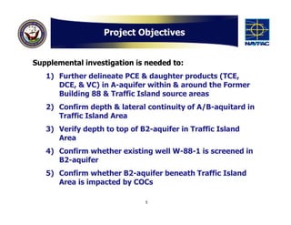
  • 5. Project Objectives Supplemental investigation is needed to: 1) Further delineate PCE & daughter products (TCE, DCE, & VC) in A-aquifer within & around the Former Building 88 & Traffic Island source areas 2) Confirm depth & lateral continuity of A/B-aquitard in Traffic Island Area 3) Verify depth to top of B2-aquifer in Traffic Island Area 4) Confirm whether existing well W-88-1 is screened in B2-aquifer 5) Confirm whether B2-aquifer beneath Traffic Island Area is impacted by COCs 5
  • 6. Technical Approach Phase 1 – Semi-quantitative Screening Survey To further assess the distribution of CEs and soil lithology in the areas of interest Phase 2 – Monitoring Well Installations & Sampling To fill in data gaps of the current groundwater monitoring well network 6
  • 8. SCAPS Probe From: U.S. Army Corps of Engineers, 2002, Cost and Performance Report for Tri-Service SCAPS MIP, January , ERDC/EL TR-02-1 8
  • 9. MIP/DSITMS System Membrane interface probe (MIP)/ Direct sample ion-trap mass spectrometer (DSITMS) detector System  Semi-quantitative COC concentration data (mg/L of calibration solution)  MIP data are only considered estimates (USACE, 2002) <http://el.erdc.usace.army.mil/elpubs/pdf/trel02-1.pdf>  Results by MIP system are relative & should be verified by soil and groundwater samples (EPA, 2012) <http://www.clu-in.org/characterization/technologies/mip.cfm> 9
  • 10. SCAPS Test Results – Former Bldg 88 General Tier 1 SCAPS test location Groundwater Flow Direction Tier 2 SCAPS test location µg/Lcs denotes micrograms per liter of DSITMS calibration solution 11.1 ft bgs 210,000 µg/Lcs – MIP 440 µg/L - GW Maximum MIP/DSITMS 11.5 ft bgs 0.45 mg/kg - Soil 830,000 µg/Lcs – MIP Response & Groundwater 660 µg/L - GW 8.8 mg/kg - Soil and Soil Results PCE 10 ~6 to 16 ft bgs (Fine-grained Sediment Interval)
  • 11. SCAPS Test Results – Former Bldg 88 General Tier 1 SCAPS test location Groundwater Flow Direction Tier 2 SCAPS test location µg/Lcs denotes micrograms per liter of DSITMS calibration solution 18 ft bgs 50,000 µg/Lcs – MIP Maximum MIP/DSITMS 78 µg/L - GW 1.9 mg/kg - Soil Response & Groundwater and Soil Results PCE 11 ~16 to 27 ft bgs (Coarse-grained Sediment Interval)
  • 12. SCAPS Test Results – Former Bldg 88 General Tier 1 SCAPS test location Groundwater Flow Direction Tier 2 SCAPS test location Maximum MIP/DSITMS Response & Groundwater and Soil Results PCE 12 ~27 to 40 ft bgs (Fine-grained Sediment Interval)
  • 13. SCAPS Test Results – Former Bldg 88 General Tier 1 SCAPS test location Groundwater Flow Direction Tier 2 SCAPS test location Maximum MIP/DSITMS Response & Groundwater and Soil Results PCE 13 ~40 to 56 ft bgs (Coarse-grained Sediment Interval)
  • 14. SCAPS Test Results – Former Bldg 88 General Tier 1 SCAPS test location Groundwater Flow Direction Tier 2 SCAPS test location Maximum MIP/DSITMS Response & Groundwater and Soil Results PCE ~56 to 70 ft bgs (Coarse & Fine-grained 14 Sediment)
  • 15. Preliminary Findings 1) SCAPS results generally correlate well with historical data 2) MIP/DSITMS detections of PCE primarily in fine-grained sediments 3) Highest MIP/DSITMS detections of TCE & DCE primarily in fine- grained sediments 4) Vinyl chloride was not detected in any of the MIP/DSITMS samples 5) Fine-grained sediments acting as a continuing source of chemicals to the groundwater 6) MIP/DSITMS responses are over 10-times higher than collocated discrete depth groundwater sample results 7) Discrete depth groundwater results are 10-times lower than estimated effective solubility limits 8) Discrete depth soil results are over 10-times lower than estimated soil saturation concentrations 15
  • 16. Potential Well Locations Former Bldg 88 Area General Groundwater Flow Direction New Monitoring Well 11.1 ft bgs 210,000 µg/Lcs – MIP 440 µg/L - GW 11.5 ft bgs 0.45 mg/kg - Soil 830,000 µg/Lcs – MIP 660 µg/L - GW 8.8 mg/kg - Soil 16
  • 17. Planned SCAPS Locations Traffic Island Area General Groundwater Flow Direction 17 0 to 23 ft bgs
  • 18. Planned SCAPS Locations Traffic Island Area General Groundwater Flow Direction 18 23 to 46 ft bgs
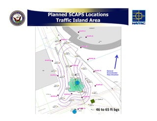
  • 19. Planned SCAPS Locations Traffic Island Area General Groundwater Flow Direction 19 46 to 65 ft bgs
  • 20. Planned Well Locations Traffic Island Area 20
  • 21. Field Work Timeline Tier 2 SCAPS at Former Bldg 88 Area – Spring 2013 Tiers 1 & 2 SCAPS at Traffic Island Area – Spring 2013 Monitoring Well Installations – Summer 2013 Groundwater Sampling – Summer & Fall 2013 21
  • 22. Questions? Point of Contact: Scott Anderson BRAC Environmental Coordinator (619) 532-0938 scott.d.anderson@navy.mil 22