Location via proxy:   [ UP ]  
[Report a bug]   [Manage cookies]                
SlideShare a Scribd company logo
Urban Planning Applications of GIS
• GIS can be applied to many types of
problem. Among these are representatives
of both raster and vector data base
structures, both simple and complex
analytical models. Master planning
applications are one of them.
Urban Planning Applications of GIS
• Especially for area monitoring (both on a
sectoral and integral basis), regional
potential and feasibility analyses and site
selection studies. For studies in which plan
alternatives are generated, much more
flexible design, optimization and evaluation
tools would be needed in order to give GIS
a dominant position in the development
process.
Urban Planning Applications of GIS
• GIS can also be helpful for the documentation of
spatial plans and in the approval process for the
development, building and installation permits.
• GIS applied to a wide range of land management
and land use planning issues including the
interpretation and formulation of land use policy.
Land-use policy can be interpreted within GIS
using a modeling approach.
Urban Planning Applications of GIS
• Output in the form of maps showing areas in
which land-use changes are more likely to occur,
and statistics, graphs and tables summarizing this
information according to a variety of specified
spatial units. Such output allows land-use
implications to be discussed.
• The predicted land-use changes can also form
input for GIS-based impact assessment.
Urban Planning Applications of GIS
GIS have become of increasing significance for environmental
planning and assessment in recent years. One reason for this, a
great number of spatial data with their attributes is involved in
environmental planning. GIS represents a highly efficient
instrument for such planning tasks. GIS can be used to develop
natural and cultural resource inventory to identify
contamination sources, to assess environmental constraints,
selection of sites for land application of sewage waste.
Suitability for several treatment techniques can be considered
using soil, topographic and land use factors, integrated with
information about the biological, chemical and physical
properties of waste.
Urban Planning Applications of GIS
Wetland applications of GIS are another
examples. Wetland issues have become a major
source of interest to the professional and to the
public.Unlike other environmental issues that
are localized or found only in certain areas,
wetlands are found almost everywhere. GIS and
remote sensor technologies supply information
of a more general nature. In a regional inventory
satellite and high altitude image data sets can
provide a valuable resource or focal point for
data analyses.
Urban planing & gis
Urban planing & gis
Urban planing & gis
Urban planing & gis

More Related Content

Urban planing & gis

  • 1. Urban Planning Applications of GIS • GIS can be applied to many types of problem. Among these are representatives of both raster and vector data base structures, both simple and complex analytical models. Master planning applications are one of them.
  • 2. Urban Planning Applications of GIS • Especially for area monitoring (both on a sectoral and integral basis), regional potential and feasibility analyses and site selection studies. For studies in which plan alternatives are generated, much more flexible design, optimization and evaluation tools would be needed in order to give GIS a dominant position in the development process.
  • 3. Urban Planning Applications of GIS • GIS can also be helpful for the documentation of spatial plans and in the approval process for the development, building and installation permits. • GIS applied to a wide range of land management and land use planning issues including the interpretation and formulation of land use policy. Land-use policy can be interpreted within GIS using a modeling approach.
  • 4. Urban Planning Applications of GIS • Output in the form of maps showing areas in which land-use changes are more likely to occur, and statistics, graphs and tables summarizing this information according to a variety of specified spatial units. Such output allows land-use implications to be discussed. • The predicted land-use changes can also form input for GIS-based impact assessment.
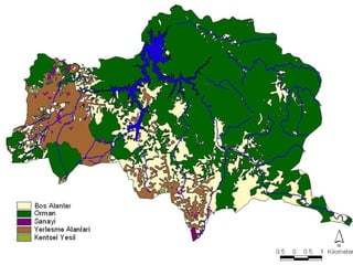
  • 5. Urban Planning Applications of GIS GIS have become of increasing significance for environmental planning and assessment in recent years. One reason for this, a great number of spatial data with their attributes is involved in environmental planning. GIS represents a highly efficient instrument for such planning tasks. GIS can be used to develop natural and cultural resource inventory to identify contamination sources, to assess environmental constraints, selection of sites for land application of sewage waste. Suitability for several treatment techniques can be considered using soil, topographic and land use factors, integrated with information about the biological, chemical and physical properties of waste.
  • 6. Urban Planning Applications of GIS Wetland applications of GIS are another examples. Wetland issues have become a major source of interest to the professional and to the public.Unlike other environmental issues that are localized or found only in certain areas, wetlands are found almost everywhere. GIS and remote sensor technologies supply information of a more general nature. In a regional inventory satellite and high altitude image data sets can provide a valuable resource or focal point for data analyses.