


Water Shed Management
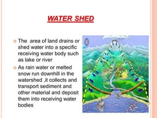
- 2. WATER SHED The area of land drains or shed water into a specific receiving water body such as lake or river As rain water or melted snow run downhill in the watershed ,it collects and transport sediment and other material and deposit them into receiving water bodies
- 4. WATER CYCLE
- 5. Water shed management The process of creating and implementing and use practices and water management practices to protect and improve the quality of water and other natural resources within a watershed by managing the use of those land and water resources in a comprehensive manner
- 6. Objective of water shed management Protecting ,conserving and improving the land resources for efficient and sustained production Protecting and enhancing water resources, moderating floods, increasing irrigation, and conserving rain water for crops Protecting the fertile top soil To manage and utilize the runoff water for useful purpose To rehabilitate the deteriorating lands To increase infiltration of rainwater To enhance the ground water recharge ,whenever applicable Maximizing farm income through agricultural related activities Improve socio-economic status of farmer
- 7. Factor effecting function of watershed management Size: Size of watershed determine the quantity of rainfall can be stored Topography: • Steep slope contribute more runoff due to less infiltration • The length of the slope also effect the runoff Soil characteristics: • Clayey soil absorb less water and contribute more water to shed • Sandy soil infiltrate more water and no watershed structure are built in this place
- 9. Hydrological aspects Hydrological behavior of water shed in influenced by watershed conditions These measure effects flood control ,soil moisture conservation and land use Environmental aspect Development green foliage ,and reduce erosion to improve ecosystem
- 10. ADMINISTRATIVE AND POLITICAL ASPECT Watershed management require close collaboration of various planning and implementing agencies to achieve full benefit of the program me Planning should only include those measures which are acceptable politically Socio-economic aspect In achieving the true objective of water shed management, the viewpoint of individuals and communities, who live in the watershed should be consider It also determine the motivation of farmer to make necessary investment of labor and capital in watershed development
- 11. Financial aspects : The PROJECTS CAN BE FOUNDED BY GOVERNMENT OR NGO’S The unit cost of watershed development normally range from RS 4500 to 6000 per hectare depending on nature and location of water shed
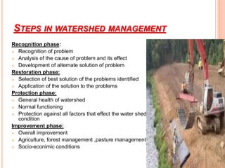
- 14. STEPS IN WATERSHED MANAGEMENT Recognition phase: Recognition of problem Analysis of the cause of problem and its effect Development of alternate solution of problem Restoration phase: Selection of best solution of the problems identified Application of the solution to the problems Protection phase: General health of watershed Normal functioning Protection against all factors that effect the water shed condition Improvement phase: Overall improvement Agriculture, forest management ,pasture management Socio-econimic conditions
- 15. CLASSIFICATION OF WATER SHED Depend upon size Macro watershed (400-1000 Ha) Sub-watershed (200 -400 Ha ) Mini watershed (40-200 Ha) Small watershed(10-40 Ha ) Micro watershed (0-40 Ha)
- 16. COMPONENT OF WATERSHED MANAGEMENT 1. Soil and water conservation measure: Reduce soil erosion All water in watershed is drain into to common point 3. water harvesting and water management : Direct collection of rain water To be use in domestic ,agriculture and in irrigation or store 3. Alternate land use system: same land may be suitable range pasture management and for tree farming ,dry land horticulture and forestry system including crops all these system which are alternate to crop production is called alternate land use
- 17. Soil and water conservation with water harvesting stone bund Alternate land use
- 18. WATERSHED MANAGEMENT PRACTICES Vegetative measure /Agronomical measure Strip cropping Pasture cropping Grass land cropping Woodlands Engineering measure/structural practices Contour budding Terracing Construction of check dames Construction of farm ponds Gull controlling structure
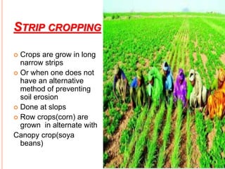
- 19. STRIP CROPPING Crops are grow in long narrow strips Or when one does not have an alternative method of preventing soil erosion Done at slops Row crops(corn) are grown in alternate with Canopy crop(soya beans)
- 20. 1.BROADS BEDS AND FURROWS Function: To control erosion and to conserve soil moisture in the soil during rainy days General information: .The land level taken and it is laid using either animal drawn or tractor drawn ridges Furrow is kept 0.15m and the inter furrow spacing is kept 1.5 m Cost : Approximate cost for laying beds and furrows is RS.1800/ha Salient feature : Conserve soil moisture in dry land Control soil erosion Acts as a drainage channel during heavy rainy days
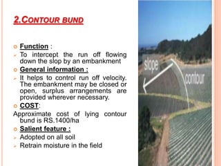
- 21. 2.CONTOUR BUND Function : To intercept the run off flowing down the slop by an embankment General information : It helps to control run off velocity. The embankment may be closed or open, surplus arrangements are provided wherever necessary. COST: Approximate cost of lying contour bund is RS.1400/ha Salient feature : Adopted on all soil Retrain moisture in the field
- 22. GRADED BUNDING These are constructed where excess of water in remove safely to avoid water stagnation Constructed in area of medium and high rain fall
- 23. BENCH TERRACING Function: It help to bring slopping land into different level strips to enable cultivation General informationon: It consist of construction of steps like fields along contours by half cutting and half filling .original slop is converted into level fields .the vertical land horizontal intervals are decided base on level slope. Cost : Approximate cost for laying the terrace is 5000/ha
- 24. Salient feature : Suitable for hilly regions It is adapted to the soil with slopes greater then 6 percent
- 25. 5.CHECK DAM Salient feature : A low weir normally constructed across the gullies Constructed on small streams and long gullies formed by erosive activity of flood water It cuts the velocity and reduce erosive velocity the stored water improves soil moisture of the adjoining area and allow percolation recharge aquifer Height depend on the bank , height varies from a meter to 3 meter and length varies from3 to 10m
- 26. PERCOLATION POND Function “ To augment the ground water recharge Salient feature : Shallow depression created at lower portions in natural or diverted stream course Preferable under gentle sloping stream where narrow valley exist with located in the soil of permeable nature Adaptable where 20-30 ground water wells for irrigation exist
- 27. WATER SHED PROGRAMM IN PAKISTAN Government Programs in Watershed Management Soil and water conservation in Barani areas(1975) Mangla dam watershed management program ( 1967) Tarbela Dam watershed management program(1975) Rawal dam watershed program (1962) Shahpur watershed management program Sustainable Mountain Development Aga Khan Rural Support Program (1982) Kalam Integrated Development Project (1981) PATA Project (1996). Malakand Fruit and Vegetable Development Project (1988) Shinkiari Tea Research and Development Programme (1986)
- 28. Soil and water conservation in Barani areas(1975) the growing damage of soil erosion due to unregulated exploitation of the forests. construction of ponds and mini-dams dug wells, hand pumps Mangla dam watershed management program ( 1967) storage capacity of 6.5 billion m3 costs Rs. 3.172 billion to construct Terbela dam watershed management program ( 1967) Tarbela dam is the world’s largest earth-fill dam storage capacities are 13.7 and 11.5 billion m3 The construction cost was Rs. 14 billion
- 29. Shahpur Dam Watershed Management total storage capacity is around 17.7 million m3 Kalam Integrated Development Project The main objective of the project is to improve the socio-economic conditions of population in the project area through people participation in forestry, agriculture and village development, PATA project: bottom up approach of agricultural development Malakand Fruit and Vegetable Development Project1988 The goal is to improve the income of small farmers by supporting their fruit and vegetable related activities Shinkiari Tea Research and Development Programme 1986 A pioneering tea plantation .
- 30. WATER RECOURSES IN PAKISTAN
- 31. RAWAL WATER SHED OF PAKISTAN
- 32. Thank you