Dartington
Appearance
| Dartington | |
|---|---|
 The Cott Inn, dating from 1320 | |
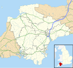
Location within Devon | |
| Population | 876 (2011 census) |
| District | |
| Shire county | |
| Region | |
| Country | England |
| Sovereign state | United Kingdom |
| Post town | TOTNES |
| Postcode district | TQ9 |
| Dialling code | 01803 |
| Police | Devon and Cornwall |
| Fire | Devon and Somerset |
| Ambulance | South Western |
| UK Parliament | |
Dartington is a village in Devon, England. Its population is 876.[1] The electoral ward of Dartington includes the surrounding area and had a population of 1,753 at the 2011 census.[2] It is located to the west of the River Dart, south of Dartington Hall and approximately two miles (3 km) north-west of Totnes. Dartington is home to an obsolete cider press (now the centrepiece of a shopping centre named after it[3]), the Cott Inn, a public house dating from 1320, and Dartington Hall.
Education
[edit]- Dartington International Summer School of music, every summer since 1953
- Dartington College of Arts, which was founded in 1961 and moved to Falmouth in 2008
- Dartington Hall School, a private school located at Dartington Hall between 1926 until it closed in 1987
- Schumacher College
- Dartington Primary School, a state Church of England school.[4]
- Bidwell Brook School

Notable people
[edit]- Robert Froude (1771–1859), Rector of Denbury and of Dartington from 1799 to his death
- Hurrell Froude (1803–1836), Anglican priest and an early leader of the Oxford Movement.
- William Froude (1810–1879), an English engineer, hydrodynamicist and naval architect.
- James Anthony Froude FRSE (1818–1894), an English historian, novelist, biographer and editor of Fraser's Magazine.[5]
- Leonard Knight Elmhirst FRSA (1893–1974), philanthropist and agronomist, co-founded the Dartington Hall project.
- David Gawen Champernowne (1912–2000), economist and mathematician, family seat at Dartington Hall.
References
[edit]- ^ "Parish population 2011". Retrieved 19 February 2015.
- ^ "Ward population 2011". Retrieved 19 February 2015.
- ^ "Dartington Cider Press Centre". Dartington Trading Company. Archived from the original on 26 August 2008.
- ^ "Dartington Primary School". Archived from the original on 14 September 2008.
- ^ Hunt, William (1911). . Encyclopædia Britannica. Vol. 11 (11th ed.). pp. 252–253.
External links
[edit]- The Dartington Hall Trust
- Dartington Parish Council
- Devon County Council's page on Dartington
- The Social Research Unit at Dartington
- Dartington in 1868
- Bidwell Brook School

