Joel Joel, Victoria
Appearance
| Joel Joel Victoria | |
|---|---|
| Coordinates | 37°00′S 143°00′E / 37.000°S 143.000°E |
| Population | 17 (SAL 2021)[1] |
| Postcode(s) | 3381 |
| Location | |
| LGA(s) | Shire of Northern Grampians |
| State electorate(s) | Ripon |
| Federal division(s) | Wannon |
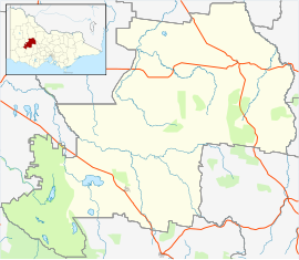
Joel Joel is a locality in the Shire of Northern Grampians, 23 km east of Stawell in the Wimmera region of Victoria, Australia.
History
[edit]Before European settlement
[edit]The traditional owners of the area are the Dja Dja Wurrung or Jaara people who are part of the larger Kulin nation.
Early years
[edit]Joel Joel Post Office opened on 19 August 1892, closed in 1895, reopened in 1902 and closed again in 1965.[2]
Modern period
[edit]In 1914 a railway line was established to connect Joel Joel and other nearby towns to the main line to the south which ran between Ararat and Avoca.
Facilities and Attractions
[edit]A new CFA Fire Station was opened on 18 March 2011 by Parliamentary Secretary Bill Tilley MP.[3]
References
[edit]- ^ Australian Bureau of Statistics (28 June 2022). "Joel Joel (suburb and locality)". Australian Census 2021 QuickStats. Retrieved 28 June 2022.
- ^ Phoenix Auctions History, Post Office List, retrieved 29 March 2021
- ^ CFA Connect News article Archived 15 April 2011 at the Wayback Machine Opening of Joel Joel Fire Station, posted 5 April 2011


