
Portal:Myanmar
ကြိုဆိုပါတယ်။ / Welcome to the Myanmar Portal 

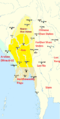
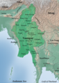
Myanmar, officially the Republic of the Union of Myanmar and also known as Burma (the official name until 1989), is a country in Southeast Asia. It is the largest country by area in Mainland Southeast Asia and has a population of about 55 million. It is bordered by Bangladesh and India to its northwest, China to its northeast, Laos and Thailand to its east and southeast, and the Andaman Sea and the Bay of Bengal to its south and southwest. The country's capital city is Naypyidaw, and its largest city is Yangon (formerly Rangoon).
Myanmar is a member of the East Asia Summit, Non-Aligned Movement, ASEAN, and BIMSTEC, but it is not a member of the Commonwealth of Nations despite once being part of the British Empire. Myanmar is a Dialogue Partner of the Shanghai Cooperation Organization. The country is very rich in natural resources, such as jade, gems, oil, natural gas, teak and other minerals, as well as also endowed with renewable energy, having the highest solar power potential compared to other countries of the Great Mekong Subregion. However, Myanmar has long suffered from instability, factional violence, corruption, poor infrastructure, as well as a long history of colonial exploitation with little regard to human development. In 2013, its GDP (nominal) stood at US$56.7 billion and its GDP (PPP) at US$221.5 billion. The income gap in Myanmar is among the widest in the world, as a large proportion of the economy is controlled by cronies of the military junta. Myanmar is one of the least developed countries; as of 2020, according to the Human Development Index, it ranks 147 out of 189 countries in terms of human development, the lowest in Southeast Asia. Since 2021, more than 600,000 people were displaced across Myanmar due to the surge in violence post-coup, with more than 3 million people in dire need of humanitarian assistance. (Full article...)
Selected articles -
-

Buddhism (Burmese: ဗုဒ္ဓဘာသာ), specifically Theravāda Buddhism (Burmese: ထေရဝါဒဗုဒ္ဓဘာသာ), is the official and state religion of Myanmar since 1961, and practiced by nearly 90% of the population. It is the most religious Buddhist country in terms of the proportion of monks in the population and proportion of income spent on religion. Adherents are most likely found among the dominant Bamar people, Shan, Rakhine, Mon, Karen, and Chinese who are well integrated into Burmese society. Monks, collectively known as the sangha (community), are venerated members of Burmese society. Among many ethnic groups in Myanmar, including the Bamar and Shan, Theravada Buddhism is practiced in conjunction with the worship of nats, which are spirits who can intercede in worldly affairs.
Regarding the practice of Buddhism, two popular practices stand out: merit-making and vipassanā meditation. There is also the less popular weizza path. Merit-making is the most common path undertaken by Burmese Buddhists. This path involves the observance of the Five precepts and accumulation of good merit through charity (dana, often to monks) and good deeds to obtain a favorable rebirth. The meditation path, which has gained ground since the early 1900s, is a form of Buddhist meditation which is seen as leading to awakening and can involve intense meditation retreats. The weizza path is an esoteric system of occult practices (such as recitation of spells, samatha and alchemy) believed to lead to life as a weizza (Burmese: ဝိဇ္ဇာ Pali: vijjā), a semi-immortal and supernatural being who awaits the appearance of the future Buddha, Maitreya (Arimeitaya). (Full article...) -
The Salween is a Southeast Asian river, about 3,289 kilometres (2,044 mi) long, flowing from the Tibetan Plateau south into the Andaman Sea. The Salween flows primarily within southwest China and eastern Myanmar (Burma), with a short section forming the border of Burma and Thailand. Throughout most of its course, it runs swiftly through rugged mountain canyons. Despite the river's great length, only the last 90 km (56 mi) are navigable, where it forms a modest estuary and delta at Mawlamyine. The river is known by various names along its course, including the Thanlwin (named after Elaeocarpus sp., an olive-like plant that grows on its banks) in Burma and the Nu Jiang (or Nu River, named after Nu people) in China. The commonly used spelling "Salween" is an anglicisation of the Burmese name dating from 19th-century British maps.
Due to its great range of elevation and latitude coupled with geographic isolation, the Salween basin is considered one of the most ecologically diverse regions in the world, containing an estimated 25 percent of the world's terrestrial animal species and thousands of plant species. Along its course the Salween provides water for agriculture and supports abundant fisheries, especially in the delta region. The Salween basin is home to numerous ethnic minority groups, whose ancestors largely originated in the Tibetan Plateau and northwest China. Starting about 5,000 years ago, people began migrating south along the river, establishing small kingdoms and city-states. (Full article...) -

Wing of the dragonfly Burmalindenia in a cabochon of Burmese amber, showing typical red colouration of the amber. Scale bar = 5mm
Burmese amber, also known as Burmite or Kachin amber, is amber from the Hukawng Valley in northern Myanmar. The amber is dated to around 100 million years ago, during the latest Albian to earliest Cenomanian ages of the mid-Cretaceous period. The amber is of significant palaeontological interest due to the diversity of flora and fauna contained as inclusions, particularly arthropods including insects and arachnids but also birds, lizards, snakes, frogs and fragmentary dinosaur remains. The amber has been known and commercially exploited since the first century AD, and has been known to science since the mid-nineteenth century. Research on the deposit has attracted controversy due to the role of the amber trade in funding internal conflict in Myanmar and hazardous working conditions in the mines where it is collected. (Full article...) -
The Saffron Revolution (Burmese: ရွှေဝါရောင်တော်လှန်ရေး) was a series of economic and political protests and demonstrations that took place during August, September, and October 2007 in Myanmar. The protests were triggered by the decision of the national military government to remove subsidies on the sales prices of fuel. The national government is the only supplier of fuels and the removal of the price subsidy immediately caused diesel and petrol prices to increase by 66–100% and the price of compressed natural gas for buses to increase 500% in less than a week.
The various protests were led by students, political activists, including women, and Buddhist monks and took the form of a campaign of nonviolent resistance, sometimes also called civil resistance. (Full article...) -
Naypyidaw (officially romanized Nay Pyi Taw and also spelled as Naypyitaw and Nay Pyi Daw) (Burmese: နေပြည်တော်; MLCTS: Nepranytau; pronounced [nèpjìdɔ̀] lit. 'Grand Capital'), is the capital and third-largest city of Myanmar. The city is located at the centre of the Naypyidaw Union Territory. It is unusual among Myanmar's cities in that it is an entirely planned city outside of any state or region. The city, then known only as Pyinmana District, officially replaced Yangon as the administrative capital of Myanmar on 6 November 2005; its official name was revealed to the public on Armed Forces Day, 27 March 2006.
As the seat of the government of Myanmar, Naypyidaw is the site of the Union Parliament, the Supreme Court, the Presidential Palace, the official residences of the Cabinet of Myanmar and the headquarters of government ministries and military. Naypyidaw is notable for its unusual combination of large size and very low population density. The city hosted the 24th and 25th ASEAN Summit, the 3rd BIMSTEC Summit, the Ninth East Asia Summit, the 2013 Southeast Asian Games and the 2014 AFC U-19 Championship. (Full article...) -

Effect of the 2004 Indian Ocean earthquake on Myanmar
Official reports from the government of Myanmar (Burma) cite a death toll of 90 due to the tsunami caused by the 2004 Indian Ocean earthquake on 26 December 2004. However, some estimates put the toll at between 400 and 600. 30,000 citizens of Burma were estimated to be in need of shelter, food and water, and 788 buildings were reported damaged and destroyed.
An NGO estimated that 2,500 citizens of Burma based in Phang Nga Province, Thailand during the event may have been killed, and that 7,000 Burmese were still unaccounted for. Many of these missing were, however, not presumed to be dead. Many refugees fled to Thailand's interior after the destruction, or were deported or chased back into the hills that divide the countries by Thai authorities. (Full article...) -
The Irrawaddy River (Burmese: ဧရာဝတီမြစ်, pronounced [ʔèjàwədì mjɪʔ], official romanisation: Ayeyarwady) is the largest river in Myanmar. Originating from the confluence of the N'mai and Mali rivers, it flows from north to south before emptying through the Irrawaddy Delta in the Ayeyarwady Region into the Andaman Sea. Its drainage basin of about 404,000 square kilometres (156,000 sq mi) covers 61% of the land area of Burma, and contains five of its largest cities.
As early as the sixth century, the river was used for trade and transport, and an extensive network of irrigation canals was developed to support agriculture. The river is still of great importance as the largest commercial waterway of Myanmar. It also provides important ecosystem services to different communities and economic sectors, including agriculture, fisheries, and tourism. (Full article...) -
Tattooing in Burma was a widespread custom practiced by various ethnic groups, including the Bamar, Shan, and Karen, until the 20th century. Tattooing was a distinguishing cultural marker and a symbol of strength, courage and intimidation for Lethwei fighters. (Full article...)
-
Bogyoke Aung San (Burmese: ဗိုလ်ချုပ် အောင်ဆန်း; MLCTS: aung hcan:, pronounced [àʊɰ̃ sʰáɰ̃]; 13 February 1915 – 19 July 1947) was a Burmese politician, independence activist and revolutionary. He was instrumental in Myanmar's struggle for independence from British rule, but he was assassinated just six months before his goal was realized. Aung San is considered the founder of modern-day Myanmar and the Tatmadaw (the country's armed forces), and is commonly referred to by the titles "Father of the Nation", "Father of Independence", and "Father of the Tatmadaw".
Devoted to ending British Colonial rule in Burma, Aung San founded or was closely associated with many Burmese political groups and movements and explored various schools of political thought throughout his life. He was a life-long anti-imperialist and studied socialism as a student. In his first year of university he was elected to the executive committee of the Rangoon University Students' Union and served as the editor of its newspaper. He joined the Thakin Society in 1938 and served as its general secretary. He also helped establish the Communist Party of Burma in 1939 but quit shortly afterwards due to vehement disagreements with the rest of the party leadership. He subsequently co-founded the People's Revolutionary Party (later the Burma Socialist Party) with the primary goal of Burmese independence from the British. (Full article...) -
The Sino-Burmese War (Chinese: 清緬戰爭; Burmese: တရုတ်-မြန်မာ စစ်ပွဲများ), also known as the Qing invasions of Burma or the Myanmar campaign of the Qing dynasty, was a war fought between the Qing dynasty of China and the Konbaung dynasty of Burma (Myanmar). China under the Qianlong Emperor launched four invasions of Burma between 1765 and 1769, which were considered one of his Ten Great Campaigns. Nonetheless, the war, which claimed the lives of over 70,000 Chinese soldiers and four commanders, is sometimes described as "the most disastrous frontier war that the Qing dynasty had ever waged", and one that "assured Burmese independence". Burma's successful defense laid the foundation for the present-day boundary between the two countries.
At first, the Qing emperor envisaged an easy war, and sent in only the Green Standard Army troops stationed in Yunnan. The Qing invasion came as the majority of Burmese forces were deployed in their latest invasion of Siam. Nonetheless, battle-hardened Burmese troops defeated the first two invasions of 1765–1766 and 1766–1767 at the border. The regional conflict now escalated to a major war that involved military maneuvers nationwide in both countries. The third invasion (1767–1768) led by the elite Manchu Bannermen nearly succeeded, penetrating deep into central Burma within a few days' march from the capital, Ava (Inwa). But the bannermen of northern China could not cope with unfamiliar tropical terrains and lethal endemic diseases, and were driven back with heavy losses. After the close call, King Hsinbyushin redeployed his armies from Siam to the Chinese front. The fourth and largest invasion got bogged down at the frontier. With the Qing forces completely encircled, a truce was reached between the field commanders of the two sides in December 1769. (Full article...)


Did you know (auto-generated) -

- ... that as part of the coronation of Mindon Min, the square yuzana around the capital was designated a sanctuary?
- ... that Aung Myo Min, Union Minister of Human Rights for the National Unity Government of Myanmar, is the country's first openly LGBT minister?
- ... that squatters in Myanmar were punished for protesting against the 2021 coup d'état by being evicted?
- ... that one academic described the introduction of femboys to Myanmar as a tactic to achieve an "ideological revolution"?
- ... that the Myanmar Coast Guard was initially proposed as a civilian law enforcement agency before being established as a branch of the military three years later?
- ... that former Burmese actress Honey Nway Oo turned rebel and took up arms against the military junta following the 2021 Myanmar coup d'état?
- ... that clashes between the Myanmar military and local armed groups broke out in Lay Kay Kaw six years after it was established as a "town of peace" between the parties?
- ... that Thinzar Shunlei Yi hid in the Burmese jungle for a month and joined a rebel militia following the 2021 Myanmar coup d'état?
Related portals and projects
General images -
-
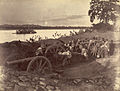 British soldiers dismantling cannons belonging to King Thibaw's forces, Third Anglo-Burmese War, Ava, 27 November 1885. Photographer: Hooper, Willoughby Wallace (1837–1912). (from History of Myanmar)
 -
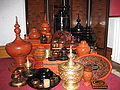 A wide range of Burmese lacquerware from Bagan (from Culture of Myanmar)
 -
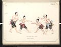 Boxing match, 19th-century watercolour (from Culture of Myanmar)
 -
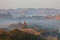
 The shores of Irrawaddy River at Nyaung-U, Bagan (from Geography of Myanmar)
 -
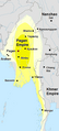 Pagan Kingdom during Narapatisithu's reign. Burmese chronicles also claim Kengtung and Chiang Mai. Core areas shown in darker yellow. Peripheral areas in light yellow. Pagan incorporated key ports of Lower Burma into its core administration by the 13th century. (from History of Myanmar)
 -
 Aung San Suu Kyi addresses crowds at the NLD headquarters shortly after her release. (from History of Myanmar)
 -
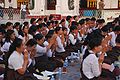 A group of Buddhist worshipers at Shwedagon Pagoda, an important religious site for Burmese Buddhists (from Culture of Myanmar)
 -
 The paddle steamer Ramapoora (right) of the British India Steam Navigation Company on the Rangoon river having just arrived from Moulmein. 1895. Photographers: Watts and Skeen (from History of Myanmar)
 -
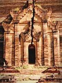 A large fracture on the Mingun Pahtodawgyi caused by the 1839 Ava earthquake. (from Geography of Myanmar)
 -
 Aerial view of a burned Rohingya village in Rakhine state, Myanmar, September 2017 (from History of Myanmar)
 -
-
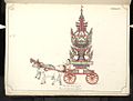 19th-century funeral cart and spire, which would form part of the procession from the home to the place of cremation (from Culture of Myanmar)
 -
 Political Map of Burma (Myanmar) c. 1450 CE. (from History of Myanmar)
 -
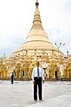 Former US President Barack Obama poses barefoot on the grounds of Shwedagon Pagoda, one of Myanmar's major Buddhist pilgrimage sites. (from Culture of Myanmar)
 -
 Myinhkin thabin - equestrian sport (from Culture of Myanmar)
 -
 A theatrical performance of the Mon dance (from Culture of Myanmar)
 -
 Vegetable stall on the roadside at the Madras Lancer Lines, Mandalay, January 1886. Photographer: Hooper, Willoughby Wallace (1837–1912). (from History of Myanmar)
 -
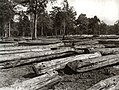
 Jade Mine in Hpakant (from Geography of Myanmar)
 -
 Hlei pyaingbwè - a Burmese regatta (from Culture of Myanmar)
 -
 Two female musicians play the saung at a performance in Mandalay. (from Culture of Myanmar)
 -
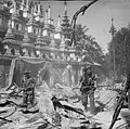 British soldiers on patrol in the ruins of the Burmese town of Bahe during the advance on Mandalay, January 1945. (from History of Myanmar)
 -
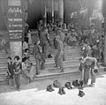 British soldiers remove their shoes at the entrance of Shwedagon Pagoda. To the left, a sign reads "Foot wearing is strictly prohibited" in Burmese, English, Tamil, and Urdu. (from Culture of Myanmar)
 -
-
-
 Sculpture of Myanmar mythical lion (from Culture of Myanmar)
 -
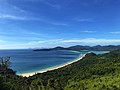 Grandfather Island, Dawei (from Geography of Myanmar)
 -
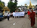 Protesters in Yangon with a banner that reads non-violence: national movement in Burmese, in the background is Shwedagon Pagoda. (from History of Myanmar)
 -
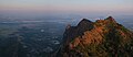
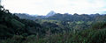 Mountains near Pindaya on the Shan Plateau (from Geography of Myanmar)
 -
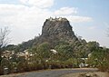 Mount Popa, a dormant volcano in the Central Lowlands (from Geography of Myanmar)
 -
 Recorder's Court on Sule Pagoda Road, with the Sule Pagoda at the far end, Rangoon, 1868. Photographer: J. Jackson. (from History of Myanmar)
 -
 The restored Taungoo or Nyaungyan dynasty c. 1650 CE. (from History of Myanmar)
 -
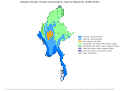 Myanmar (Burma) map of Köppen climate classification (from Geography of Myanmar)
 -
 Portuguese ruler and soldiers mounting an Elephant. Philips, Jan Caspar (draughtsman and engraver) (from History of Myanmar)
 -
 Salween river at Mae Sam Laep on the Thai-Myanmar border (from Geography of Myanmar)
 -
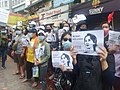 Protesters in Yangon carrying signs reading "Free Daw Aung San Suu Kyi" on 8 February 2021. (from History of Myanmar)
 -
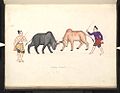 A bull fight, 19th-century watercolour (from Culture of Myanmar)
 -
 Temples at Mrauk U, was the capital of the Mrauk U Kingdom, which ruled over what is now Rakhine State. (from History of Myanmar)
 -
 Saint Mary's Cathedral in Downtown Yangon is the largest Roman Catholic cathedral in Burma. (from Culture of Myanmar)
 -
-
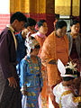
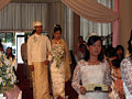 A wedding procession, with the groom and bride dressed in traditional Burmese wedding clothes, reminiscent of royal attire (from Culture of Myanmar)


_headquarter.jpg)


Major topics
Categories

More topics

Associated Wikimedia
The following Wikimedia Foundation sister projects provide more on this subject:
-
 Commons
Free media repository -
 Wikibooks
Free textbooks and manuals -
 Wikidata
Free knowledge base -
 Wikinews
Free-content news -
 Wikiquote
Collection of quotations -
 Wikisource
Free-content library -
 Wikiversity
Free learning tools -
 Wikivoyage
Free travel guide -
 Wiktionary
Dictionary and thesaurus


